Technology , People mind & Environment situation are main factors of human settelment creation in all generation from early ancestors till Today's postpostmodern thinking . In this page We explain an experience in implementing thecnology to manage people minds & environment situation for creating better place in urban landscape .
Human being for evolution and promote his way of life depends on different subjects.Recreation and refreshing mind are parts of these demands that must be focused on urban environment studies . From ancient time until now there have been various respons to recreation request , for example ancient egyptian built holly gardens as there tombs , chambers or private orchards.
Creating "PARADISE" was Iranian art and knowledge as recreation public places. Greek's public parks were
an obvious revolution in designing of urban open space . japenese and chinese people had oreintal philosophy approach to recreational places . building symmetric garden with emphasis on topiary plants and picturescal formal trees were the format of urban recreational places in most territory of world untill 18'th century . Naturalism and being obey of Earth resourse had shaked the way of revitalization of residential places from 18'th century until now. Humphry Repton had mixed the various style of public garden construction and his method remained until end of 19'th century . symbolism , functionalism , deconstruction and so on were countinued the ways of
parks design .
You can see the complex circle of various interactive between Man and his recreational demand , but you can also observe enormous similarity between Man and his recreational creature . Technology , people mind and environment situation are common subjects in birth and growth of urban parks as the main place of recreation and refreshing human's brain .
Fredrick Law Olmstead was another person to make our attention on essense of combenation between urban hard surface ( structures ) and urban soft surface ( natural resources ) as recreational response to residintial leisure requests . This approach was promote by landscapers like Jefery Jeleco to demonstrating the value of urban parks .
The role of technology has been more effictive by progress of designing and planning tools and facilites .
In the middle of 1960's a Scotman introduced a new way of thinking , living and even thogh refreshing . He was Ian Mcharg who explained the way of information classification by seperating the similar criteria or objects on special "COVERAGE" and modelised them by analysing and creating the special simmulation for planing the special purpouse and scenario . The methodology of Mcharg and his way of thinking was another evolution in the age of "INFORMATION TECHNOLOGY" for landscaper and environment designer .
Again technology gave it's hand to people minds for best using of environment situation to create utopia for making balance between structure and nature in urban .
On the end of 1970's J.E.Lovelock taught us accept our earth like our body by respect to "GAIA" . (Homage to GAIA, Oxford 2000) In the ages of GAIA if you dicide to design your part of earth you must study all of it's body exactly like a doctor who treats his patient.
Multicriteria sutdy and designing the best decisions needs accessing to information . In this case there is a little difference between medical science and environment design ! The amount of information that must be studied are completely deffernt in two case . In one subject we study only a part of body but in another case our subject is a part of earth .
Mcharg taught us the way of interacting , using and classifying the tremendously volume of earth data . but what about the role of technology to solve our deciding problem in designing environment and simulating our future forecasting ? If you ask this question from J.Dangermond the manager of ESRI(Environment Systems Research Institute) he suddenly answers you;"GIS" .
Giographical Information Systems are systems with special collection of software and hardware technology , proficienal talents and mind and information of environment situation that have been processed . We can imagin that Mcharg and his idea was introduce of GIS but the fact is ; GIS is a product that belongs to lot of minds who desired one day better technology makes better mind and better mind makes better environment situation . people like Elliot , Jellico , Olmsted , Repton and even though ancient egyption designer are the real inventors and owner of GIS . GIS belongs to all user of geospatial data and the persons who need to assesment ,analysing and simulating the real world in virtual format . The ways of designing parks and urban recreational space are also promoting and the situation of evolution in technology and minds suerly would be remained .
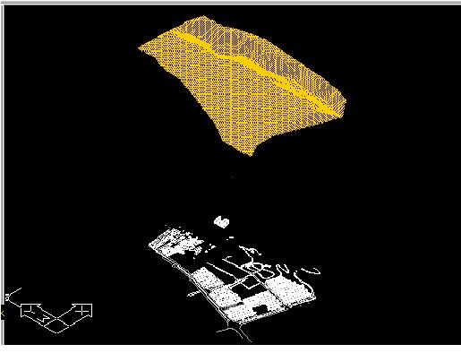
Just at this moment many wounderful projects are implementing by environment designers and landscaper for applying modern technology in manageing the environment situation . By evolution of GIS , it changed to multidimensional GIS and the metods of surface assessment developed to space assessment . After demonstrating the important effect of multidimensional GIS in accurating landscape study, this question was highlighted: "whats happen after multidimentional GIS ?" . The answer of this question cause another evolution in technology and people minds , this evolution known as "VIRTUAL REALITY" . The best example of this attempt was done at "VENUE" (Virtual Environments for Urban Environments) project . This project implemented by "CASA" (Center for Advanced Spatial Analysis ) group and a lot of virtual dreams about digital decesion support systems by space analysing and participation decesion minds, by there effort comes true .
When ancient egyption learn the technology of "PAPYROUS" product,they successed in evolutionised there environment situation by preparing better media for minds , thinking and decesion for creating better urban living , better urban sustainibility and also better urban recreation. GIS & VIRTUAL REALITY completed this role in past decade. We can participating minds , gathering a huge amount of information in different scale , clasification and analysing data , simulating and modelising various purpouses and also fly in virtual space or have a useful conversation with our colleagues by "AVATAR" in multidimensional GIS and environment simulation .
In this article,in addition to a review of concepts related to urban parks and recreational needs of city dwellers, two new concepts emerging in the field of " urban landscape" are also presented : Geographic Information Systems and virtual reality .
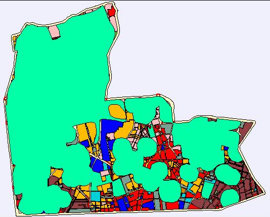
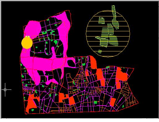
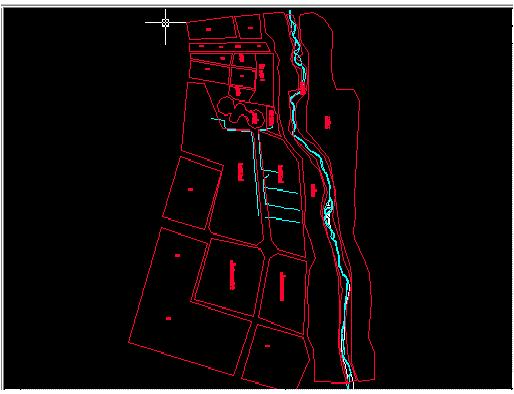
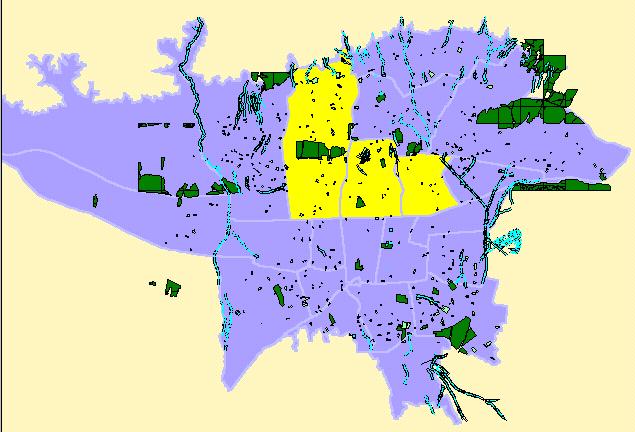
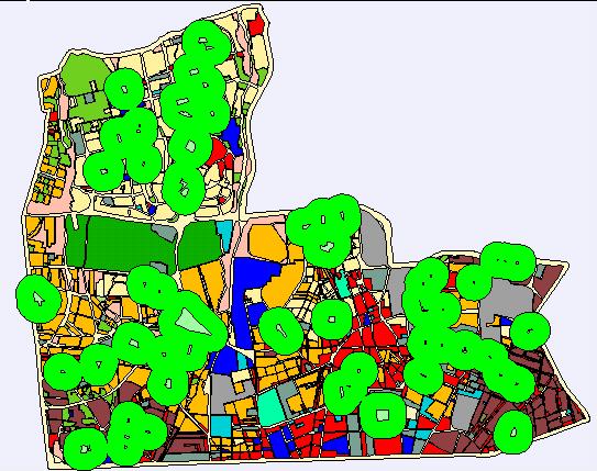
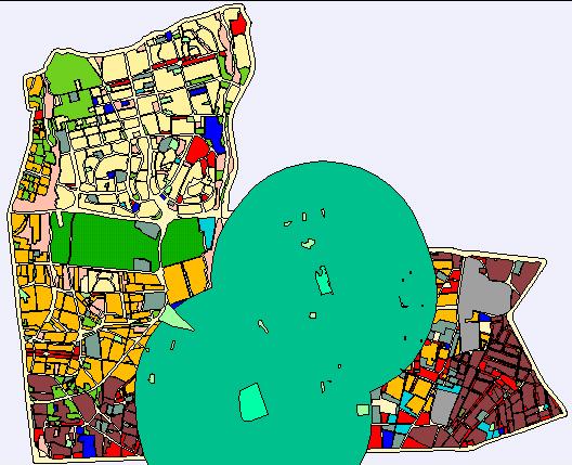
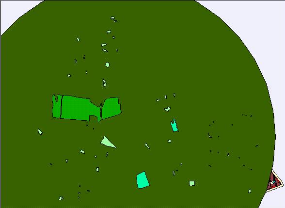
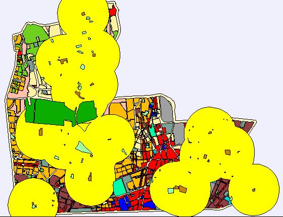
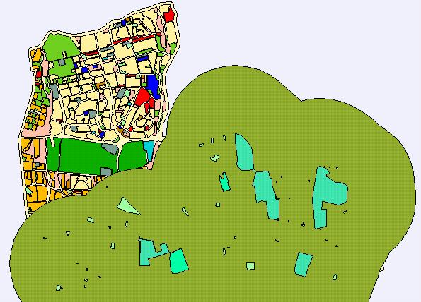
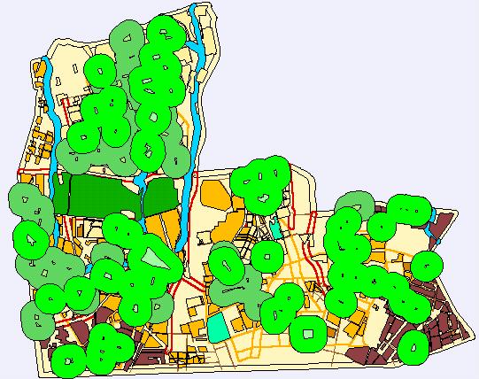
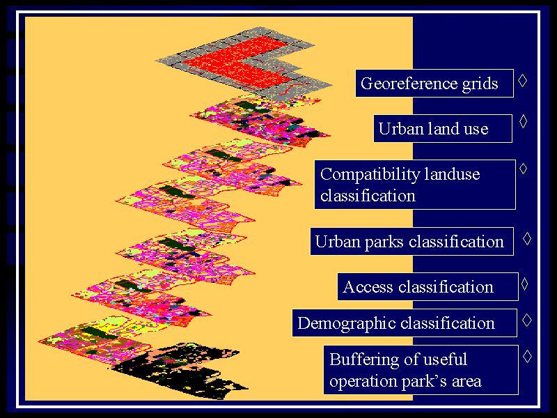
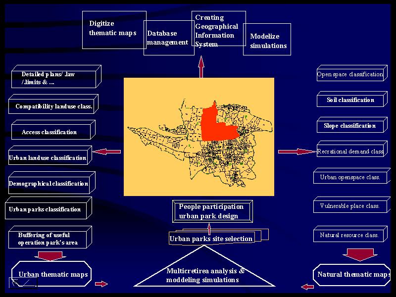
Here , after presenting the significance of the research and its objectives, GIS as a decision tool in finding suitable land for urban park in three districts of Tehran metropolitan area is discussed and implemented . In the next step, one site in the study region is chosen and designed as a recreational park.
The main concept & focal point of this project contains three idea."ENVIRONMENT DESIGNING SYSTEM","VIRTUAL INFORMATION TECHNOLOGY FOR URBAN LANDSCAPE" & "VIRTUAL INFORMATION TECHNOLOGY FOR INTERNATIONAL URBAN LANDSCAPE" then We known them as "EDS","VITULA"& "VITIULA"
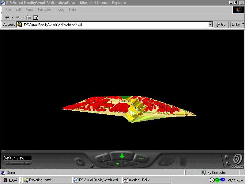
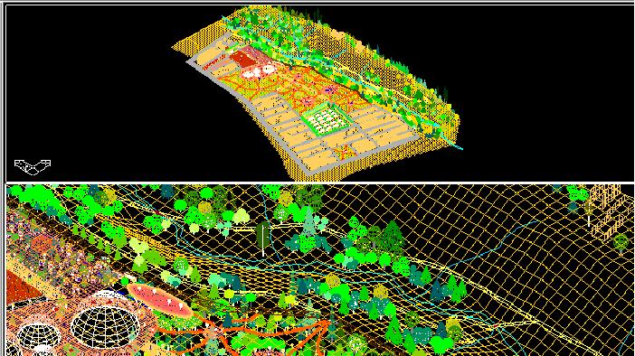
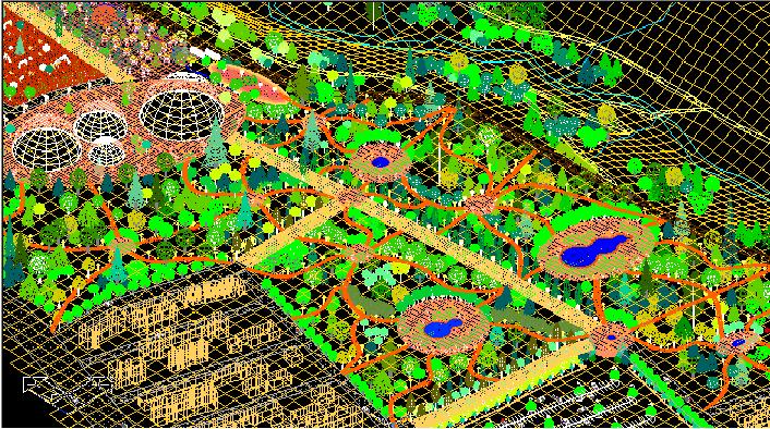
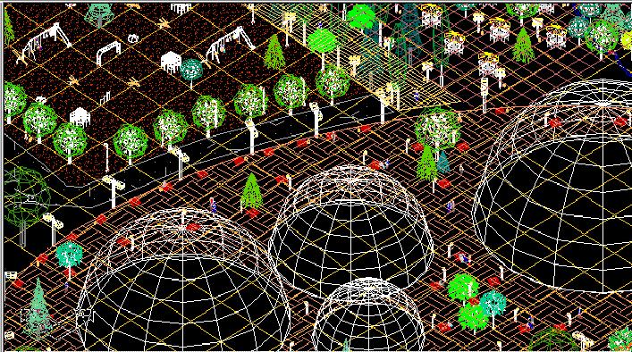
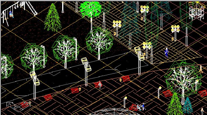
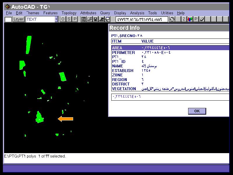
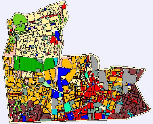
In front of you there are methodology, steps & concepts of the new way of urban landscape designing by VITULA . Each picture display the special concept for classification , site selection,creating virtual space,participating people & experts in designing there recreational area or local park .
Now is the time for global thinking,global designing & global deciding and also the time for local act, local implement & local preserving . If we observe Earth as a one body so the essence of global participation in urban landscape design will be focused . VITULA is one way for gathering public opinion and use these expectations in final dececion . For having a sustainable urban landscape we need to obey the popular demand and how many the best idea will be implemented , the urban landscape space will be more sustainable
Last section of this web site will explain the essencial base or fundementals of future urban landscape. Sustainable urban green area, Urban agriculture , Edible landscape , People participation , New generation of urban park design , Virtual Information Technology for International Urban LAndscape (VITIULA) , GIS,VRIS, Urban park classification , EDS, RS,Virtual simulations, VRML & ....... are part of topics that VITULA try to use . Information technology let us to cooporate internationaly for designing our local landscape . I hope you join me to implement successfuly this idea .
This site is a full customized page for only one desire , "creating sustainable urban landscape by use of virtual information technology" , so two groups of people may be main participator of this project . First landscapers,urban designers,ecologists,environment designers,architectures & all experts who think about there environment situations . Second all people of world who notice , preserve & develope there local landscape as part of one Earth . We request the help of both groups to designing sustainable & better urban landscape for our world .