|
|


 |
Canadian West Coast: Considered to be one of the worlds greatest dive location, the Canadian west coast is home to a multitude of life and shipwrecks. You're guaranteed to see something new every dive - be it an octopus, a wolf eel, or even an orca. Living in these waters are a huge variety of fish (ling cod, halibut, various rockfish, and many others we don't know the name for), pods of orca's (killer whales), white-sided dolphins, seal, sea lions, giant pacific octopi, wolf eels, sea stars, nunibranches, and a sea floor carpeted in anemones. In addition, ship wreaks abound - including several destroyer escorts sunk by the Artificial Reef Society. The Canadian west coast is one of the best ranked dive area's in the world! Several dive magazines and societies have ranked the West coast in their top 5 dive locals. These include Rodale's SCUBA Diving, the most-read SCUBA magazine, who ranked the west coast as their #1 site in 2003. The Cousteau Society ranked the west coast of Canada #2 in the world for biodiversity - second only to the Red Sea! There isn't really a down side to diving the coast, but there are a few things you need to take into consideration. The visibility here is moderate, meaning that it can vary from 3m (10') to ~30m (100') or more. The waters are cool, 8-12C (46-54F). The area is also home to large tides, and the currents which come with them. Ironically, it is these currents which feed the beautiful eco system which divers come here to enjoy. But suck it up cupcake - grab a 7mm wet suit, or even a dry suit, and take a trip to the coast. The quality of diving more then makes up for the minor inconveniences. General advice for this area - dive during slack (the times around high and low tide). Currents will be at their lowest at slack, making diving easier. Make sure you have tide tables, and check with local divers as the time the currents are at their lowest may not exactly correlate with slack. If you're an experienced drift divers there are several dives that can be done as drifts - we don't drift dive (yet), so we can't advise you on this. Included on this page are dive sites we've dived in and around Victoria, on Vancouver Island. A few dives shops are also listed on the maps. These are the shops we've used, there are several other great shops on the island. The descriptions are a combination of what we've read plus our own experience. Keep in mind that this is only a small number of the dives available - contact a local dive shop for more info, or read these pages:
Our dives: Sannich Area: Victoria and Greater Victoria: NOTE: Dives marked with an astrix (*) are protected marine environments. Removing items, spear fish, collection of shellfish, or removal of any life or artifacts from these area's is strictly prohibited . Please respect these and all other dive sites so the diving remains excellent for years to come. Map #1: Southern Victoria Island - for reference, no dives
(click for a larger map).
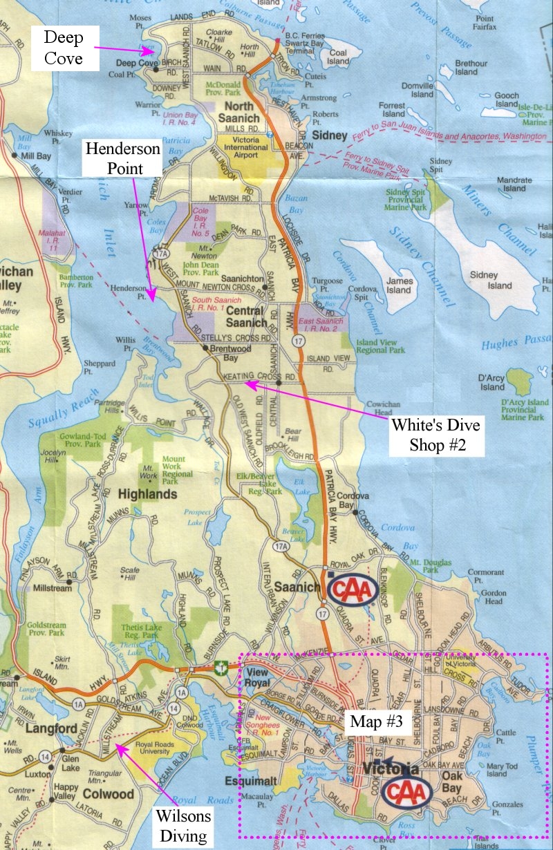
Map #2: Victoria and Sannich area (click for a larger map)
Location: To get to Henderson Point, drive out Blanshard St. and it turns into Hwy #17 (Pat Bay). Drive until you come to Mt. Newton X Rd., where there is a Quality Inn and a MacDonald's. It is the first intersection past the row of billboards. Turn left onto Mt. Newton X Rd., and follow it past several sets of stop signs. Keep going straight and eventually you will reach West Saanich Road. Cross West Saanich onto Senanus Rd. Senanus has a few sharp turns (one left, one right) but follow it to its terminus where there is a small parking lot. Please park courteously and be quiet - this is a residential area. The path is at the end of the lot, between two stones. Underwater: This is one of Victoria's best shore dives, second only to Ten Mile and Ogden Point. Because of it's location deep in the Sannich inlet this site receives little circulation, except at the surface. As a result the upper 7-10m (20 or 30 feet) of water tend to have very low viability, but the water gets clearer as you enter lower layers. In 2002 we had visibility of at least 100m (300') - at depth below 25m (80')!!! Henderson Point has a series of shelves, each in a different layer of water and with a different series of species. Entry is down a path from the cul-de-sac. You have to climb down the small cliff to the beach - the dead tree makes a good handhold, but watch your head. There is a cliff to the right of the beach, with a flagpole. To find the first reef swim directly out (west) from the flag pole about 10m (30'). Descending from this point will put you in about 10m (30') of water, on top of the first reef. The remaining reefs are north west of here, at deeper depths. . The first reef has a lot of leaf kelp, anenomes, small fish and a multitude of small invertebrates. The second reef, at 20m (60') has fewer small animals, but larger species of rockfish, greenlings, juvenile wolfeels and various other fish populate this reef. Between the second and third reef lies a field of shells - probably left by feeding octopi. The third reef sits at 25 to 30m (80 to 90'). Large fish, such as halibut, sole are found here. Giant nudibranchs baby octopus and squid have been reported by other divers. Although we have never seen them, 6-gilled sharks have been known to fed at the deeper reefs during the summer. When on the deeper reefs watch your gauges - the shelves continue down to 100m (300'), and it's easy to accidentally exceed safe depths. Warnings: During the summer these waters are populated by cyanea jellyfish, which can give an unwary diver a nasty sting. These jellyfish have a large bell and tentacles upto 20m (65') long! There are a lot of boats in this area, so dive a flag. Unfortunately many of them do not know what a dive flag is, so keep your head up when surfacing in case one has come over for a look. Location: There are two sites which can be used to access this site. The free site is found by driving towards the ferry terminal on Hwy #17. Exit onto Wain Rd and follow it west until it ends. Turn right at the 'T' intersection (Madrona Drive) and drive three or so blocks to Setchell Rd. Follow Setchel to its end. A pathway brings you down onto a small point - the wreak is a short swim from there. The second entry point is at the marina - simply take Madrona past Setchell Rd. and go around the corner. Just turn in at the sign for the marina. For $3 you can park in the marina and use the dock - for $5 you also get an air fill! Underwater: A long time ago a train barge struck a reef just outside Deep Cove. It almost made it to the marina, but sunk a few feet short in about 20m (65') of water. No one knows who owned it, who was on it, and exactly when it sank. It is 152 feet long, and home to a huge number of fish. At this point the wreak is beneath a faded pink spherical buoy. This may change, so check with a local dive shop or the marina before you head in. From the top of the dock the buoy is located at an angle of about 45 degrees to the left (the buoy is visible under the tall wharf). If facing the tip of the point, the buoy is about 90 degrees to your left. Make sure you get the right buoy - there are a lot to pick from. Because the wreak is starting to disintegrate penetration is not recommended. But there is plenty to see on the outside. Also, an addition was made to this site recently. Half of a speed boat can be found near the marker buoy. This sunk in the spring of 2002. Someone didn't pay their moorage fees, and as the boat was being towed out of the bay it broke up, the from half nearly coming down on the mystery wreak! Warnings: Watch for boat traffic. Always dive this dive at high tide - you need the layer of cold, clear water at the bottom, otherwise you'll only have the murky waters of the by. It's your choice - 20' visibility or 2' visibility.
Map #3: Victoria City (click for a larger map)
Location: The breakwater is on Dallas Road, about 2km west of Beacon Hill Park. The Breakwater is located on Dallas Road just west of beacon Hill Park. Drive up Douglas St. from downtown and hang a right at Mile Zero. Then go till you see the Breakwater. Parking is allowed on the street and there is ample angle parking. There is also parking on the other side of the Breakwater, but costs $0.50 for 2 hours. Underwater: The breakwater is an 800m long structure made of stacked granite blocks and concrete. It is home to an amazing amount of life, and benefits from weak currents. The Breakwater is divided into 5 sections called "flags". These are dive flags painted on the Breakwater with plaques sunken at the bottom under each flag. The plaques are an overview of the site and have marine identification keys on them. Each flag is progressively deeper, with the first flag at about 8m (25'), and the fifth flag at 25m (75'). The diving at each flag varies. The area's upto the third flag feature a lot of smaller fish, small invertebrates, kelp and all the creatures that live in kelp. After the third flag things start to change. As the water gets deeper larger species start to appear - ling cod, wolf eels and octopi are the more exciting example of the life which abounds here. Rockfish, scallops and numerous other species also make their home in the deeper waters. Some of the best diving is found between the 4th and 5th flags. Waters in this region can get as deep as 34m (110'). Among the rocks gigantic plume anenomes and ling cod can be found. All of the species that are found elsewhere on the breakwater are found here, but they're bigger and there's more of them (probably because this area is rarely dived or fished). So strap on your gear, and prepare for a long march! The walk is worth every step. Warnings: Be careful when climbing on the blocks because the sharp barnacles can slice open your suit. It is illegal to dive the west side of the Breakwater because of boat traffic. Rarely strong currents can develop around the last bend - if diving at peak current periods you may not be able to swim into these. Or you can start at the end and let the currents carry you around the bend - it's your choice Location: Ten mile can be hard to find, so ask the local dive store for directions. From downtown find a way onto Cadboro Bay Rd. Take Cadboro north until you are beside UVic from here Cadboro will curve towards the ocean. Watch closely, and turn right onto Seaview Rd. Take the first left onto Tudor Ave. Take Tudor to Baynes Rd, turn right onto Baynes and follow this to White Rock St. At the end of White Rock is a small parking lot above a steep rock embankment - this is the point! Entry: Getting into the water here can be a challenge. On the left of the parking lot is a fence. A faint path passes below the fence, and down to the water. This is the best way down, but this route can be treacherous, so be careful. Enter the water at the end of this path - you want to be on the left end of the point, as the most interesting stuff is immediately below the parking lot, and the currents here almost always will carry you to the right. Be careful as you enter as the rocks are very slippery. Underwater: This is a fantastic wall dive. The constant currents keep the area clear of plankton, as such the visibility here is usually the best in the city. As soon as you get in the water submerge, and follow the bottom to the wall. The wall itself extends from 15m (40') to 25m (80'). The wall is carpeted from top to bottom in white plume anenomes - sometimes they are so dense you cannot see the wall behind them. Among the anenomes live every species of fish you can imagine. In places the wall is so colourful it looks like the canvas of an impressionist artist! If you look carefully you may find a large octopus - on our last dive here we found a 5 footer! Wolf eels may be found in the rocks at the bottom of the wall. Cold water corals and numerous invertebrates also make there home here. Some people have even seen orca's close up at this site! Unfortunately the currents which feed this wonderful site are our greatest enemy. This dive should only be dived at slack, and even during slack there will be currents. The best time to hit this site is during a small tidal change. During large tidal changes your dive window may only be 20 minutes. on our first dive here we were 5 minutes late entering the water. As a result we had to hang onto the kelp for dear life during our safety stop - the current went from ~1/6 of a knot to 1 knot in a few minutes. Exit: There are several exit options. If possible you want to stay below the parking lot as this is where the best stuff is. If you stay here the easiest way out is just to walk up the cliffs beneath the first house. Although this wall is nearly impassable going down, it's like climbing stairs going up. Further down there is a pathway between the third and fourth house. This is the most popular exit. If you miss the path don't fear. Stick close to the shore and allow the surface currents carry you completely around the point. On the far side of the point (about 1 block) is a small bay where you can exit and access the road. Warnings: As mentioned previously this is a current swept dive, and even at slack this is a drift dive. ALWAYS dive this site at slack unless you are very skilled at drift diving. DO NOT dive this site if you are unfamiliar or uncomfortable with currents.
Location: Ask for directions at a dive shop, as this place can be a challenge to find. Drive out Blanshard St. from downtown, and hang a right at Hillside Rd. Drive out Hillside for about 10 minutes till you come to Cadboro Bay Rd., where you turn left. You will reach a 4 way stop at Sinclair Rd. where there is a small mall and a couple of Pubs. Continue straight, and the road does a couple of twists, first right, then left. Just after the left twist, turn right onto the road marked Seaview, and follow it as it curves left. Follow this road past a sharp left curve. The road continues until you see it split around a tree growing in the middle of the road. Just past that tree is Spring Bay Underwater: Spring Bay consists of a series of shelves dropping about 10 feet for each one. There is tons of parking here, with stairs to the beach, which is a small bay. Because of shallower depths, Spring Bay is much better suited to beginning divers than Ten Mile. Much of the same life is extant here, with many sightings of Octopus, Wolfeels, and Grunt Sculpins. The shallow area is home to Pacific Clingfish and Marbled Snailfish. Also found here are the odd Kelp Poacher and Spiny Lumpsucker. Sharpnose Crabs and Decorator Crabs are everywhere, and sea urchins fill all the cracks. Entry is off the beach. Use your buddy to stabilize yourself getting in, and swim as soon as it's deep enough. The cobble here is of larger size, and because it is covered in slippery algae it carries real potential for twisted ankles. Do not drop gear at this site. It has a reputation for "eating" equipment, since the leaf kelp on the bottom and silt in the shallows makes recovery of dropped gear virtually impossible. Make your dives down the shelves, but be sure to take a heading for the beach when you descend. It is easy to get turned around at this spot. If you get lost, follow the shelves up, and eventually you will get to shore, though you may be a long swim from your entry. It is easy to climb onto the rocks anywhere along here. Warnings: Check the current before diving. It can be quite strong and pull you all the way to Ten Mile. Generally, the current is at the surface only, and disappears or even reverses direction at depth. Location: To get there from downtown, cross the Johnson St. Bridge (going out Pandora St.) and find yourself on Esquimalt Rd. Continue straight past Lampson St. and the Esquimalt Rec Centre and Mr. Grocer. Just past this complex, turn left onto Fraser St. Drive to the end of Fraser St where you will see a sign for Saxe Point Park. The site is at the end of this road. There are washrooms here as well. Underwater: Fondly known as "crap point" by our crew, we consider this to be the worst dive in the area. Turns out we dove in the wrong place (a small bay on the west side of the park. Great for your first ocean dive - little current or waves, not a a lot to distract you from your buoyancy (but then again nothing to see). The other two dives seem a little more interesting, but all we ca do is provide you with someone else's description... A small memorial park in southern Esquimalt, Saxe Point is a popular training site and a good dive for beginning divers. There are two dives here. One is directly off the south end of the point. It is mostly sand bottom, and has all the life associated with such an area. In the rocks is an inordinate number of Octopus, and one expert I know says that it may be the best place in Victoria to see Octos. But I have yet to see one here...perhaps I don't know where to look. About 1.5 km out is the sewage outfall. I have heard that the outfall has an amazing amount of life, but I have never been out there. Currents are usually mild here, and the rocks off to the left offer quite an interesting dive. Dogfish and Ratfish are common here, as are Sea Pens and Sea Urchins. Usually only seen at deeper depths, I once saw a Basket Star here as well. The more popular dive is down a path to the right of the point. There is a beach here and a dive around the point to the left of the beach can be quite rewarding. The bottom is sand and silt, so be careful with your bouyancy here. It takes hours for the silt to settle. This is another mecca for Nudibranchs, and there are plenty of macro opportunities. The dive is fairly shallow, with a maximum depth of around 50 feet. I rarely dive here because of it's out of the way location, but it is a popular spot for crabbing as well as diving. Warnings: None.
|
This Page, and all other pages in the http://www.geocities.com/k_o_dionysus/ directory copyright (2004), Bryan Heit & the Knights of Dionysus