| Santa Monica Case Study (Pratt et al, 1998) |
| Introduction The Los Angeles region of southern California is a high priority area for earthquake research because a large population lives on top of an extensive system of faulting that has produced several catastrophic earthquakes in the past few decades. The Santa Monica-Hollywood fault system is among the most threatening because it lies beneath the major metropolitan centers of northern Los Angeles. The Santa Monica Fault extends east-west along the southern edge of the Santa Monica Mountains. Until recently, there was a mistaken belief that the fault was inactive because paleoseismologic trench results were equivocal and little seismicity is associated directly with the fault. Data from a 110 meter-long, 5 meter-deep trench excavated in west Los Angeles suggest that the fault has been recently active. Isotope age analysis was used on the surrounding rock to produce an estimated slip rate of 0.6 mm/yr. The most recent surface rupture may have occurred between 1000 � 3000 years ago. Methods Data Colletion High resolution seismic reflection data was collected across the Santa Monica Fault scarp to confirm the presence and determine the geometry of the fault beneath the trench site. A 3.8 km line was collected to a depth of 300 m. Due to limited access and extremely busy roads, the collection was quite difficult. Data acquisition involved going through �a golf course, thickly wooded hillsides, an arboretum, a school yard, a baseball stadium, a highway underpass and the hospital grounds�(Pratt et al, 1998, 482). Geophone spacing from the source was 7.62 m for the entire line, but adjacent common midpoints (CMPs) were summed in the processing to increase the fold and give a 7.62 m CMP spacing on the final section. Mini-Sosie sources were three earth tampers that hit the ground 2000 times per record. Advantages of the earth tampers include: spreading the source effort over a 2 � 2.5 minute time period to reduce noise, non-damaging to the ground, and portable enough to carry when necessary. Geophones were 28-Hz, with 12 per station. Processing Due to the difficult environment, the data collected was marginal. A 30 - 150 Hz band-pass filter was used, and the reflections contained a 50 - 70 Hz dominant frequency. The final profiles are time-migrated sections that have been depth-converted using a smoothed velocity function. (Common Processing Steps) |
 |
| Interpretation and Discussion The high resolution profile imaged two distinct sections separated by the Santa Monica Fault. The major finding was a possible extension of the fault to the surface beneath a major roadway. In this case, an important application is that California State law places severe restrictions on building near exposed faults, whereas "blind" faults are not addressed by this law. The seismic data provide the first confirmation that the gentle scarps near the Santa Monica Fault are geomorphic expressions of the fault. This lends support to previous research and mapping of the fault. |
| Fig. 1 Location of Study Area (L.A.) source: Yahoo! Maps |
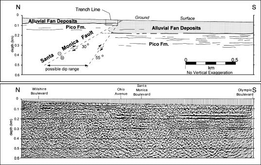 |
| Fig. 2 Upper 0.6 km of the southern 2.4 km of the high-resolution line, with line drawing and interpretation above. The Santa Monica Fault is interpreted to be a thrust fault dipping at 30��55� on the basis of the locations of reflector truncations. The prominent reflector (bold line on interpretation) on both sides of the thrust fault is interpreted to be the erosional surface at the top of the Pico Formation, with alluvial fan deposits above. Between 115 and 180 m of dip-slip motion can be interpreted on the fault depending upon how much the footwall strata have been folded (dashed lines between fault lines). Data are time migrated and converted to depth using a smoothed velocity function. The sloping line in the upper 15�85 m of the seismic profile is the location of the ground surface. (source: Pratt et al, 1998) |