Preface: This section provides definition and description of the commonly used satellite earth
orbits. It is written to be non technical and to provide sufficient
information to understand the subject but not to make one an
engineering expert. With the information presented, you will
be able to easily perform more internet searches to locate more
technical details if you wish. There are many applications in
current use for each orbit type and after a general discussion
of each orbit type we present a description of a unique orbital
application which we think will provide you with a good idea
of the maximum potential of that orbit type. This section does
not go into the technical construction and operation of satellites,
this can be found for geostationary satellites by following the
links per satellite in the Western/Eastern Hemisphere Quick-Look
sections; and for all types of low earth orbit satellites by
referring to Lloyd's
Satellite Constellations.
|
|
Introduction: There are literally
an infinite number of possible orbits for an earth satellite.
While there are special orbits that are designed for specific
purposes, three general classes of orbits have come into wide
spread use for observations of the earth and for microwave communication
with the earth: Geostationary orbits,
low earth orbits, (LEOs) and
polar orbits. Note that all
polar orbits are subsets of LEO orbits.
Geostationary
Orbit: Geostationary orbits are circular orbits 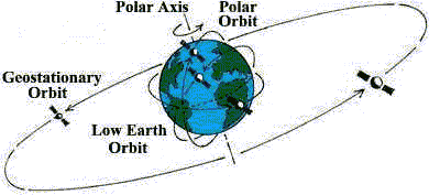 that are orientated in the plane of the earth's equator.
In a geostationary orbit, the satellite appears stationary, i.e.
in a fixed position, to an observer on earth. More technically,
a geostationary orbit is a circular prograde orbit in the equatorial
plane with an orbital period equal to that of the earth; this
is achieved with an orbital radius of 6.6107 (equatorial) earth
radii, or an orbital height of 35786 km. A satellite in a geostationary
orbit will appear fixed above the surface of the earth, i.e.
at a fixed latitude and longitude. In practice, the orbit has
small non-zero values for inclination and eccentricity, causing
the satellite to trace out a small figure of eight in the sky.
The footprint, or service area, of a geostationary satellite
covers almost 1/3 of the earth's surface (from about 75 degrees
south to about 75 degrees north latitude), so that near-global
coverage can be achieved with a minimum of three satellites in
orbit. By placing the satellite at an altitude where it's orbital
period exactly matches the rotation of the earth (approximately
35,800 km), the satellite thus appears to 'hover' over one spot
on the Earth's equator and thus appears to stay stationary over
the same point. A geostationary satellite completes one orbit
revolution in circular orbit, round the Earth, every 24 hours.
If the orbit is in the equatorial plane, and if rotation is in
the same direction as the Earth, (rotating at the same angular
velocity as the Earth) and it overflies the same point on the
globe permanently then the satellite is termed geostationary.
Geostationary satellites, however, do not see the poles at all
yet geosynchronous satellites do. (For
a more technical description of geosynchronous vs. geostationary
nomenclature.) In general, all geostationary orbits are geosynchronous,
but not all geosynchronous orbits are geostationary. Geosynchronous
means that a satellite makes one orbit every 24 hours so that
it is 'synchronized' with the rotation period of the earth. As
previously stated, this will happen when a satellite is in a
circular orbit at a rough distance of 36,000 kilometers above
the surface of the Earth, or roughly 42,000 kilometers from the
center of the earth. However, to be a geostationary satellite,
the geosynchronous satellite must be in orbit in earth's equatorial
plane - geostationary is a small subset of orbits that are geosynchronous.
The orbital location of geostationary satellites is called the
Clarke Belt in honor of Arthur C Clarke who first published the
theory of locating geosynchronous satellites in earth's equatorial
plane for use in fixed communications purposes(Clarke, Arthur
C., 1945, "Extra Terrestrial Relays", Wireless World.).
For brevity, the term 'geostationary satellite' is often shortened
to 'geo satellite'. that are orientated in the plane of the earth's equator.
In a geostationary orbit, the satellite appears stationary, i.e.
in a fixed position, to an observer on earth. More technically,
a geostationary orbit is a circular prograde orbit in the equatorial
plane with an orbital period equal to that of the earth; this
is achieved with an orbital radius of 6.6107 (equatorial) earth
radii, or an orbital height of 35786 km. A satellite in a geostationary
orbit will appear fixed above the surface of the earth, i.e.
at a fixed latitude and longitude. In practice, the orbit has
small non-zero values for inclination and eccentricity, causing
the satellite to trace out a small figure of eight in the sky.
The footprint, or service area, of a geostationary satellite
covers almost 1/3 of the earth's surface (from about 75 degrees
south to about 75 degrees north latitude), so that near-global
coverage can be achieved with a minimum of three satellites in
orbit. By placing the satellite at an altitude where it's orbital
period exactly matches the rotation of the earth (approximately
35,800 km), the satellite thus appears to 'hover' over one spot
on the Earth's equator and thus appears to stay stationary over
the same point. A geostationary satellite completes one orbit
revolution in circular orbit, round the Earth, every 24 hours.
If the orbit is in the equatorial plane, and if rotation is in
the same direction as the Earth, (rotating at the same angular
velocity as the Earth) and it overflies the same point on the
globe permanently then the satellite is termed geostationary.
Geostationary satellites, however, do not see the poles at all
yet geosynchronous satellites do. (For
a more technical description of geosynchronous vs. geostationary
nomenclature.) In general, all geostationary orbits are geosynchronous,
but not all geosynchronous orbits are geostationary. Geosynchronous
means that a satellite makes one orbit every 24 hours so that
it is 'synchronized' with the rotation period of the earth. As
previously stated, this will happen when a satellite is in a
circular orbit at a rough distance of 36,000 kilometers above
the surface of the Earth, or roughly 42,000 kilometers from the
center of the earth. However, to be a geostationary satellite,
the geosynchronous satellite must be in orbit in earth's equatorial
plane - geostationary is a small subset of orbits that are geosynchronous.
The orbital location of geostationary satellites is called the
Clarke Belt in honor of Arthur C Clarke who first published the
theory of locating geosynchronous satellites in earth's equatorial
plane for use in fixed communications purposes(Clarke, Arthur
C., 1945, "Extra Terrestrial Relays", Wireless World.).
For brevity, the term 'geostationary satellite' is often shortened
to 'geo satellite'.
Earth stations transmit a signal to a satellite in orbit,
this act is called an uplink. 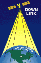  Geostationary satellites receive the uplinked signal,
amplify it, shift it to a lower frequency and then couple the
outgoing signal to the transmitting array of on-board satellite
antenna where the signal is focused into a narrow beam and sent
back to earth. The act of sending the signal back to earth is
called downlinking. The on-board satellite electronics which
receive the uplinked signal, amplify it and shift the frequencies
is called a transponder. For instance, USA C-band uplink frequencies
are from 5.925GHz to 6.425Ghz and the downlink frequencies are
from 3.7GHz to 4.2GHz; uplinks and downlinks are at different
frequencies to avoid interference with each other. Ku signals
are uplinked in the 14.0-14.5GHz range and downlinked in the
10.95-12.75GHz range. Each transponder
is configured to accept a certain bandwidth of frequencies (36MHz,
54MHz and 72MHz are common). The range of frequencies corresponds
to a 'channel', the term we use on earth. When you look at the
transponder layout, i.e. configuration, for a satellite you will
notice that channels are arranged with a band of frequencies Geostationary satellites receive the uplinked signal,
amplify it, shift it to a lower frequency and then couple the
outgoing signal to the transmitting array of on-board satellite
antenna where the signal is focused into a narrow beam and sent
back to earth. The act of sending the signal back to earth is
called downlinking. The on-board satellite electronics which
receive the uplinked signal, amplify it and shift the frequencies
is called a transponder. For instance, USA C-band uplink frequencies
are from 5.925GHz to 6.425Ghz and the downlink frequencies are
from 3.7GHz to 4.2GHz; uplinks and downlinks are at different
frequencies to avoid interference with each other. Ku signals
are uplinked in the 14.0-14.5GHz range and downlinked in the
10.95-12.75GHz range. Each transponder
is configured to accept a certain bandwidth of frequencies (36MHz,
54MHz and 72MHz are common). The range of frequencies corresponds
to a 'channel', the term we use on earth. When you look at the
transponder layout, i.e. configuration, for a satellite you will
notice that channels are arranged with a band of frequencies
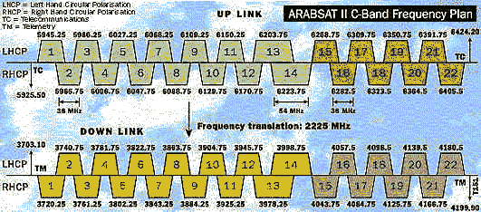 between
each one, typically 4MHz, this is known as a 'guardband' and
its purpose is to provide isolation between each channel. You
will also note that there are two sets of frequencies per transponder
and they are at opposite polarities; this is known as frequency
reuse and is a technique whereby two transponders share the same
frequency but by handling signal at opposite polarities the two
signals will not interfere with each other so each frequency
is 'reused'. (For further
discussion on polarization types.) Note to further avoid
'co-channel' interference, each set of polarities is typically
offset from each other by an amount equal to one-half of their
bandwidth, i.e. the band ends of one set of polarities fall on
the center frequencies of the other set of polarities. Nowadays,
in the age of digital compression, frequency reuse is further
obtained by digitally compressing multiple channels per transponder,
i.e. more use of each frequency is obtained by using compression
techniques to 'cram' more information into each uplink/downlink
signal. On newer satellites, some individual transponders can
be reconfigured from earth control stations to be combined to
provide a customer with more bandwidth or can be divided to lessen
the bandwidth to customer specifications (for instance a 72MHz
transponder can be broken into two 36MHz bandwidth units). between
each one, typically 4MHz, this is known as a 'guardband' and
its purpose is to provide isolation between each channel. You
will also note that there are two sets of frequencies per transponder
and they are at opposite polarities; this is known as frequency
reuse and is a technique whereby two transponders share the same
frequency but by handling signal at opposite polarities the two
signals will not interfere with each other so each frequency
is 'reused'. (For further
discussion on polarization types.) Note to further avoid
'co-channel' interference, each set of polarities is typically
offset from each other by an amount equal to one-half of their
bandwidth, i.e. the band ends of one set of polarities fall on
the center frequencies of the other set of polarities. Nowadays,
in the age of digital compression, frequency reuse is further
obtained by digitally compressing multiple channels per transponder,
i.e. more use of each frequency is obtained by using compression
techniques to 'cram' more information into each uplink/downlink
signal. On newer satellites, some individual transponders can
be reconfigured from earth control stations to be combined to
provide a customer with more bandwidth or can be divided to lessen
the bandwidth to customer specifications (for instance a 72MHz
transponder can be broken into two 36MHz bandwidth units).
In regards to earth reception, downlink antennas on a satellite
can be configured to downlink in 'global' beams (which can cover
approximately forty percent of the earth's surface), be configured
to target a region or country (sometimes called zone or 'hemi'
(hemisphere) coverage), and/or be configured to target only a
small area (called a spot beam). And individual transponders,
or groups of transponders, can be configured to cover different
parts of the earth from the same satellite; transponders that
can be reconfigured from earth control stations to change their
coverage are called 'steerable beams'. Satellite coverage of
Hawaii is a typical spot 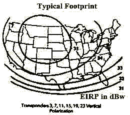 beam, satellite coverage of the continental United
States is a typical regional coverage beam and satellite coverage
by the Intelsat international consortium satellites are typical
global beams. The downlinked beam pattern is commonly called
a footprint and its mapped pattern is in contours of effective
isotropic radiated power (eirp) and calibrated in units of dBw
(decibels above one watt) (for more on
decibels). EIRP maps are used in equations called link
budgets which are used by satellite system designers to determine
which size satellite dish is required to receive beam, satellite coverage of the continental United
States is a typical regional coverage beam and satellite coverage
by the Intelsat international consortium satellites are typical
global beams. The downlinked beam pattern is commonly called
a footprint and its mapped pattern is in contours of effective
isotropic radiated power (eirp) and calibrated in units of dBw
(decibels above one watt) (for more on
decibels). EIRP maps are used in equations called link
budgets which are used by satellite system designers to determine
which size satellite dish is required to receive 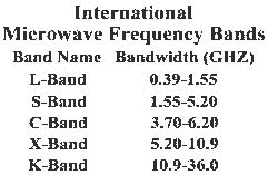 programming from each satellite. Microwave frequencies
are set by international convention and the current designations
for satellite use are L, S, C, X (military) and K (which includes
Ku and Ka) bands. (For complete
frequency spectrum list from 9KHz to 300GHz.) programming from each satellite. Microwave frequencies
are set by international convention and the current designations
for satellite use are L, S, C, X (military) and K (which includes
Ku and Ka) bands. (For complete
frequency spectrum list from 9KHz to 300GHz.)
Geo satellite applications have become to have a major global
effect on our daily lives; they are best suited to carry large
volumes of communications traffic. Virtually all today's modern
financial business is conducted at high speed via satellite example
being credit card transactions, corporate retail inventory, shipment
tracking and even the newspaper USA Today is typeset and
transmitted to printing plants via satellite. Geo satellites
rapidly and efficiently link remote areas of the Earth with telephone,
television and data information and provide transmission from
a single uplink location to provide reception to a regional downlink
pattern - this is often called point to multi-point distribution.
Satellites utilize transmit/receive signals in the microwave
frequency range. They are not deflected by the Earth's atmosphere
as lower frequencies are. Basically, they travel in a straight
line, known as line of sight communication.
Before the development of geo satellite technology, microwave
transmission was accomplished via a series of repeater 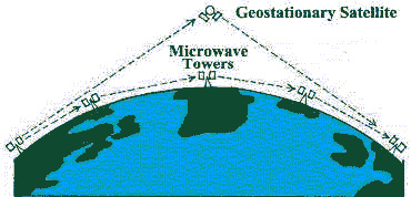 microwave towers and subsea cables. The obvious limitation
of microwave towers is they are a point-to-point technology and
limited to line-of-site in regards to their placement - a tower
is required every twenty-five miles. Microwave towers provide
no regional coverage and cabling is required to reach the end
user. The first commercial geo satellites were constructed to
augment microwave towers for telephone transmission applications
and thus were constructed to be the same frequency as microwave
towers which is C-band (centered at four MHz); therefore when
satellites were applied to television programming distribution,
the first commercial satellite TV equipment was C-band. Think
of a geostationary communications satellite as a microwave repeater
in the sky - geo satellites overcome the difficulty of long-range
communications; if a communications satellite is on a line of
sight from two points on the Earth's surface, it can act as a
relay between points too widely separated for direct transmission
by towers. microwave towers and subsea cables. The obvious limitation
of microwave towers is they are a point-to-point technology and
limited to line-of-site in regards to their placement - a tower
is required every twenty-five miles. Microwave towers provide
no regional coverage and cabling is required to reach the end
user. The first commercial geo satellites were constructed to
augment microwave towers for telephone transmission applications
and thus were constructed to be the same frequency as microwave
towers which is C-band (centered at four MHz); therefore when
satellites were applied to television programming distribution,
the first commercial satellite TV equipment was C-band. Think
of a geostationary communications satellite as a microwave repeater
in the sky - geo satellites overcome the difficulty of long-range
communications; if a communications satellite is on a line of
sight from two points on the Earth's surface, it can act as a
relay between points too widely separated for direct transmission
by towers.
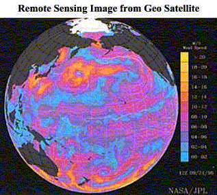 It is also important to remember that geo satellites
are used for earth observation purposes (remote sensing) in addition
to communication applications. Before the advent of geo satellite
technology, all weather predictions were based on information
from ground reporting stations, reports from pilots of aircraft
and from ships at sea, and from high altitude balloons. Can It is also important to remember that geo satellites
are used for earth observation purposes (remote sensing) in addition
to communication applications. Before the advent of geo satellite
technology, all weather predictions were based on information
from ground reporting stations, reports from pilots of aircraft
and from ships at sea, and from high altitude balloons. Can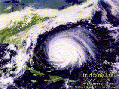 you imagine life today without satellite imagery
for hurricane tracking and landfall predictions? Today, satellite
images showing the advance of weather fronts are regular elements
of the evening news. This meteorological information is also
available to anyone with a personal computer and relatively inexpensive
hardware and software. In addition to weather, a network of American,
European, Japanese, and Russian satellites orbits the earth in
various configurations to provide "real-time" monitoring
of our environment. Useage of geo imaging satellites for civilian
purposes and scientific research include monitoring of ocean
temperature, rainfall amounts, desert encroachment, rainforest
disappearance, air quality levels, updated maps and, what we
take most for granted, daily weather reports. you imagine life today without satellite imagery
for hurricane tracking and landfall predictions? Today, satellite
images showing the advance of weather fronts are regular elements
of the evening news. This meteorological information is also
available to anyone with a personal computer and relatively inexpensive
hardware and software. In addition to weather, a network of American,
European, Japanese, and Russian satellites orbits the earth in
various configurations to provide "real-time" monitoring
of our environment. Useage of geo imaging satellites for civilian
purposes and scientific research include monitoring of ocean
temperature, rainfall amounts, desert encroachment, rainforest
disappearance, air quality levels, updated maps and, what we
take most for granted, daily weather reports.
Brief Satellite History: The world's first manmade artificial
satellite (into low earth orbit) was the launch of Sputnik 1,
by the USSR (Soviet Union), on October 4, 1957. Prior to that,
in 1948, the United States Army Signal Corps had transmitted
radar signals to the moon and bounced them back to earth proving
relatively low power microwave signals could be transmited into
space and that they could be detected on earth. In 1954, the
U.S. Navy transmitted voice messages (on microwave carriers)
to the moon then detected their reflection back on earth. On
January 31, 1958, the U.S. launched their first satellite, Explorer
1, it provided preliminary information on the environment
and conditions in space outside earth's atmosphere and resulted
in the discovery of the Van Allen radiation belts and orbit the
earth more than 58,000 times before re-entering the earth's atmosphere
over the south pacific on March 31, 1970.. The same year, the
U.S. established NASA to facilitate development of space based
technology and launched SCORE into LEO orbit; SCORE received
messages at 150MHz, taped them, then retransmitted them back
to earth. The first broadcast from space to earth was on December
19, 1958, by U.S. president Eisenhower - it was a Christmas greeting
- using the SCORE technology. An important test of the potential
of satellites for regional (continental) communications from
a single uplink was the 1960 launch, by the U.S., of Echo
1 - a passive 'satellite in reality a one hundred foot, high
altitude, balloon made of microthin (5/10,000 inch) Mylar which
received, and reflected back to earth, low power, duplex (two-way)
telephone conversations.
A very important, and practical development, in the history
of satellite communications, was the NASA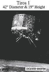 launch of Tiros
I, the world's first weather satellite, launched in April,
1960; the images it sent to earth proved that the 'space race'
would have major implications on the daily lives of the average
citizen beyond that of national pride in developing the 'best'
space program. It carried low resolution television and infrared
cameras and was in a circular polar orbit of about 600km. Proving
communications via satellite is important for business but using
satellites for earth monitoring is important for life - and this
is the dual pattern in satellite applications that has been maintained
to date. Earth monitoring satellites are not glamorous in that
they do not bring the instant gratification to stockholders and
television viewers that communications satellites do however
their role in our world is much more valuable in that we have
only one earth and the earth monitoring satellites assist us
to understand our world, its impact on us and our impact on it. launch of Tiros
I, the world's first weather satellite, launched in April,
1960; the images it sent to earth proved that the 'space race'
would have major implications on the daily lives of the average
citizen beyond that of national pride in developing the 'best'
space program. It carried low resolution television and infrared
cameras and was in a circular polar orbit of about 600km. Proving
communications via satellite is important for business but using
satellites for earth monitoring is important for life - and this
is the dual pattern in satellite applications that has been maintained
to date. Earth monitoring satellites are not glamorous in that
they do not bring the instant gratification to stockholders and
television viewers that communications satellites do however
their role in our world is much more valuable in that we have
only one earth and the earth monitoring satellites assist us
to understand our world, its impact on us and our impact on it.
Telstar 1, built by ATT, was the first satellite designed
to detect microwaves, amplify them 'on board', and then retransmit
them back to earth - the current transponder technology in use
today. Although a LEO satellite, it linked Europe and North America,
via satellite - live!!!, on television, on July 10, 1962, with
a broadcast by Elvis Presley. Telstar 1 was the first satellite
able to broadcast TV signals and Elvis was the first entertainer
to be broadcast on satellite. The first experimental geosynchronous
communications satellites were launched in 1963, Telstar 2 and
Syncom 2 (Hughes Aircraft Corp.). Syncom 3 (geo, 1964) linked
the1964 Tokyo Olympics to the United States. In 1965, the Soviets
launched the first of their Molnya
'twelve hour orbit' satellites (highly
elliptical orbit) - a clever engineering feat for providing
communications to northern latitudes not reachable by geo satellite
coverage. And in 1965 the first international geo satellite,
Intelsat 1 (commonly called 'Early Bird'), was launched (built
and coordinated by Comsat-USA) and was the first truly global
commercial satellite service. The formation of Intelsat (which
is vigorously active today), with member countries (see Intelsat
signatory list), was specifically to rapidly develop (and
distribute the cost of such development) global geo communications
services and in turn to provide geo satellite services to (and
between) member countries - the kind of thing a single country
could not do in the emerging geo satellite science. In 1969,
Intelsat completed the first global geo network, i.e. satellite
system that covered all the globe - a major achievement in only
twelve short years after the Sputnik launch, with their Intelsat
3 series; how fitting, it was completed and operational only
days before the first lunar landing, Apollo 11, July 20, 1969.
Although today we take for granted the offering of satellite
services by private companies, in the beginning, all satellite
communications were coordinated between countries through government
authorized entities and agencies and were international by design.
This changed in 1972, when Telesat (although a government monopoly),
Canada, began operation of the world's first domestic communications
satellite, Anik 1 (launched by NASA), to provide the vast Canadian
continental area with voice and data services and the idea to
provide television programming; by default of its footprint 'spread',
it was also the first geo satellite to provide service to the
U.S. domestic market - RCA immediately leased circuits on Anik
until they could launch their own satellite. The first United
States domestic communications satellite, and the world's first
offered by a private company, was Western Union's WESTAR 1, launched
on April 13, 1974, followed by Westar 2 then the RCA satellite,
Satcom F-1 which set the standard of using twenty-four channels,
however it was the 1975 Intelsat 4A series which first used dual
polarization per transponder, i.e. twelve transponders for twenty-four
channels. These first satellites were initially designed for
voice and data useage, but very quickly television became a major
user and commercial supportor. By the end of 1976, there were
120 transponders available over the U.S., each capable of providing
1500 telephone channels or one TV channel; Canada had their own
geo system; Intelsat was well on its way to another generation
of global satellites; Indonesia had become the third country
to have their own satellite - Palapa; and Comsat had launched
the first mobile communications satellite, Marisat, in February,
1976, to provide mobile services to the United States Navy and
other maritime customers.
In 1975, an east coast (USA) cable company, Home Box Office,
began delivering TV programming downlinked from satellites to
its cable subscribers. On September 30, 1975, it offered the
Muhammad Ali/Joe Frazier boxing match (Thriller in Manila) to
its cable viewers - the first precursor to 'pay for view'. In
1976, Ted Turner uplinked his WTBS Atlanta TV station to satellite
to create the first 'superstation . . . the rest is history.
In a short time, the 'movie channels' and 'super stations' were
available to most Americans and TV was on its way to dominate
satellite useage and to drive its growth as the dramatic expansion
in cable TV would not have been possible without the inexpensive
method of distributing video as provided by geo satellites. Throughout
the late '70's, satellite applications continued to grow, from
the involvement of NOAA in weather
satellites and earth observation to the 1979 sponsorship by the
United Nations International Maritime Organization of the establishment
of the International Maritime Satellite Organization (INMARSAT)
in a manner similar to INTELSAT as a method of providing international
telephone service and traffic-monitoring services on ships at
sea. As the decade of the '80's began, satellite technology had
become a technology definitely acceptable to business and science
and all the concepts and benefits of GEO, LEO, MEO and HEO satellites
were being employed or on the 'drawing board'.
Second generation geo communication satellites were hybrids
of C-band and the higher frequency Ku-band (centered at MHz)
technology (it was Telsat that launched the first commercial
hybrid satellite). Ku-band technology allowed the use of smaller
diameter satellite antennas for video reception and opened the
market for satellite delivered private data networks called VSATs
(very small aperture terminals) and extended the application
of SNG (satellite news gathering) services. With Ku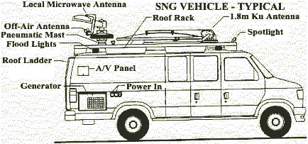 technology, it became more affordable and practical
to deliver all news via SNG vehicles. Hybrid satellites were
followed by dedicated high power Ku-band satellites designed
exclusively for the DTH (direct to home) television market with
first applications in the European and Asian TV markets where
high density urban populations and lack of TV cable networks
made the marketing of small dish TV programming, commonly called
DBS (direct broadcast services), a practical business endeavor.
High power DBS satellites now transmit consumer programming to
small dishes to homes in all corners of the globe. The newest
satellite technology in commerical application are hybrid Ku/Ka-band
satellites where Ka-band (centered around 22MHz) technology allows
for even smaller receive satellite antennas. Yet technology does
not stand still, research is continuing to theV-band (centered
around 50/60MHz) for geo global communications network applications
with broader bandwidth that utilize smaller receivers including
hand held units, inter-satellite links, on-board processing and
high-powered spot beams. brief
history of early satellite communications technology, it became more affordable and practical
to deliver all news via SNG vehicles. Hybrid satellites were
followed by dedicated high power Ku-band satellites designed
exclusively for the DTH (direct to home) television market with
first applications in the European and Asian TV markets where
high density urban populations and lack of TV cable networks
made the marketing of small dish TV programming, commonly called
DBS (direct broadcast services), a practical business endeavor.
High power DBS satellites now transmit consumer programming to
small dishes to homes in all corners of the globe. The newest
satellite technology in commerical application are hybrid Ku/Ka-band
satellites where Ka-band (centered around 22MHz) technology allows
for even smaller receive satellite antennas. Yet technology does
not stand still, research is continuing to theV-band (centered
around 50/60MHz) for geo global communications network applications
with broader bandwidth that utilize smaller receivers including
hand held units, inter-satellite links, on-board processing and
high-powered spot beams. brief
history of early satellite communications
(top of page) |
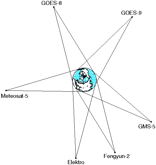
A GOES satellite can examine land features to 0.8 km. resolution. |
Satellite
Networks
Provide Global
Coverage:
This illustration of
meteorological
satellites shows
the advantage of a
geo orbit. While a
low altitude orbiting
satellite is 'hidden' for
part of its orbit
around the Earth, a
geo satellite is always
directly visible from
the same earth
geographical area,
day or night. The
field of view of a
satellite in geo orbit
is fixed. A geo orbit
is essential for a
permanent satellite
communications
system between two
points and is ideal for
repeat observations
to a fixed geogra-
phical global area. |
(top of page)
GEO System for Personal Communication:
The Inmarsat satellite system is
an example of using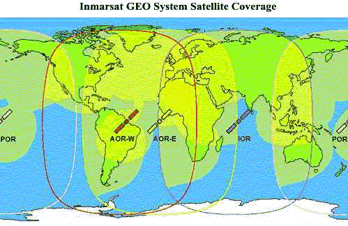 a geo orbit global system to provide global communication
services to earth users. It currently is the only provider of
global, integrated, personal communication services from geo
orbit. Its complete earth coverage (except for the poles) is
achieved through four geo satellites. Although a disadvantage
of a geostationary satellite in a voice communication system
is the roundtrip delay of approximately 250 milliseconds from
ground to satellite to ground; the advantage is in management
of the system as stationary satellites do not require the passing
of information from satellite a geo orbit global system to provide global communication
services to earth users. It currently is the only provider of
global, integrated, personal communication services from geo
orbit. Its complete earth coverage (except for the poles) is
achieved through four geo satellites. Although a disadvantage
of a geostationary satellite in a voice communication system
is the roundtrip delay of approximately 250 milliseconds from
ground to satellite to ground; the advantage is in management
of the system as stationary satellites do not require the passing
of information from satellite 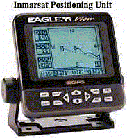 to satellite as do LEO systems. The Inmarsat system
is the first personal to satellite as do LEO systems. The Inmarsat system
is the first personal 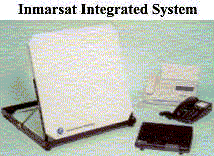 communication system designed; its technology predated
development of LEO technology. It originally was authorized,
in 1979, to provide maritime users at sea with positioning traffic
monitoring service; it now additionally provides, depending on
the type of terminal used, direct dial-up voice, facsimile, duplex
data transfer, telex, electronic mail, high quality audio, compressed
video and still video pictures, telephoto, slow-scan television,
videoconferencing and telemedicine to any global user including
services to aircraft (some of which are still in development)
and positioning/tracking/monitoring services to terrestrial communication system designed; its technology predated
development of LEO technology. It originally was authorized,
in 1979, to provide maritime users at sea with positioning traffic
monitoring service; it now additionally provides, depending on
the type of terminal used, direct dial-up voice, facsimile, duplex
data transfer, telex, electronic mail, high quality audio, compressed
video and still video pictures, telephoto, slow-scan television,
videoconferencing and telemedicine to any global user including
services to aircraft (some of which are still in development)
and positioning/tracking/monitoring services to terrestrial 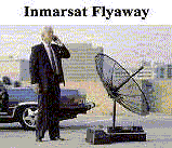 mobile systems. Its system mobile systems. Its system 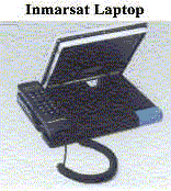 is accessible from an assortment of devices including
automatic receiving positioning mounted units for ships and trucks,
portable 'flyaway' satellite parabolic antenna units with briefcase
size terminals and the more recent digital laptop computer control
units with built in satellite antenna. Other similar geo systems
for personal communications are in the planning stages from would-be
competitors to Inmarsat; for example, Hughes is developing a
broadband four geo satellite system with emphasis on high speed,
high volume data transfer capability for personal and business
applications - all plans for future systems include capability
for Internet access. The beauty of a personal communication geostationary
satellite system is that four satellites provide global coverage;
except, of course, for the poles. is accessible from an assortment of devices including
automatic receiving positioning mounted units for ships and trucks,
portable 'flyaway' satellite parabolic antenna units with briefcase
size terminals and the more recent digital laptop computer control
units with built in satellite antenna. Other similar geo systems
for personal communications are in the planning stages from would-be
competitors to Inmarsat; for example, Hughes is developing a
broadband four geo satellite system with emphasis on high speed,
high volume data transfer capability for personal and business
applications - all plans for future systems include capability
for Internet access. The beauty of a personal communication geostationary
satellite system is that four satellites provide global coverage;
except, of course, for the poles.
Comparison
Chart of Transmission Speed Using Broadband Personal Satellite
System
as proposed by Hughes Communications |
| Application |
Information
Content |
Phone Line
28.8 Kbps |
SPACEWAY
384 Kbps |
SPACEWAY
1.5 Mbps |
|
Digitized Photo |
1 Megabit |
34 Seconds |
2.6 Seconds |
0.7 Seconds |
|
CAD/CAM |
2 Megabits |
70 Seconds |
5.2 Seconds |
1.4 Seconds |
|
X-Ray |
12 Megabits |
7 Minutes |
31.3 Seconds |
7.8 Seconds |
|
Digital Library |
Washington Post
SundayEdition |
9 Minutes |
41.6 Seconds |
10.4 Seconds |
|
An optional broad-band uplink terminal will support applications
requiring up to 6 megabits per second. |
(top of page) |
 Polar Satellites: Polar orbits are LEO orbits. Their applications
can be to view
Polar Satellites: Polar orbits are LEO orbits. Their applications
can be to view
only the poles (to fill in gaps of geo coverage) or to view the
same place on earth at
the same time each 24hr day. By placing a satellite at an altitude
of about 850 km, a
polar orbit period of roughly 100 minutes can be achieved. This
will allow the earth
to rotate beneath the satellite sufficiently that one polar satellite
be used per
application though for more continuous coverage, more than one
polar orbiting
satellite is employed. A special polar orbit that crosses the
equator and each latitude
at the same time each day is called a sun-synchronous
orbit. Polar satellites may
carry sensors sensitive to both visible light and infrared (IR)
radiation and can make
measurements of temperature and humidity in the Earth's atmosphere,
record surface
ground and surface sea water temperatures, and monitor cloud
cover and water/ice
boundaries. They may have the capability to receive, measure,
process, and
retransmit data from balloons, buoys, and remote automatic stations
distributed
around the globe. These satellites may also carry search and
rescue transponders to
help locate downed airplanes or ships in distress. Polar orbiting
satellites provide
many services in communication and observation applications which
geo satellites
are not capable of. (more
on polar satellites) |
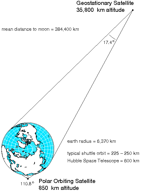
Polar Orbits:
This illustration shows
true relative distance
from the Earth of geo-
stationary and LEO
polar orbit satellites.
From geo altitude, the
entire Earth disk
subtends an angle of
17.4 degrees in
contrast to a typical
polar orbiting satellite,
which sees only a
relatively small portion
of the globe at any one
time. By definition, a
polar satellite has an
inclination of 90
degrees to the equator.
The critical design goal
is to place a polar
satellite in an orbit that
is low enough to allow
a relatively short
orbital period while at
the same time its orbit
altitude is sufficient to
permit observation of
a sufficiently wide path
so that during a single
orbit the Earth will
rotate by less than the
scan swath ability of
the satellite instrumen-
tation. A polar orbit is
fixed in space, and the
earth rotates under-
neath; a polar orbit
travels from north to
south pole. A typical
polar satellite can
cover the entire globe
every 14 days and can
'see', as example, the
entire east coast of the
at one time, from
southern Florida north
to Hudson Bay, and
from the Atlantic to
west of the Great
Lakes.(top of page) |
Low Earth Orbits (LEO): LEOs
are either elliptical or (more usual) circular orbits at a height
of less than 2,000 km above the surface of the earth. The orbit
period at these altitudes varies between ninety minutes and two
hours.  The radius of the footprint of a communications satellite
in LEO varies from 3000 to 4000 km. The maximum time during which
a satellite in LEO orbit is above the local horizon for an observer
on the earth is up to 20 minutes. (A satellite with an orbiting
altutude less than geostationary travels at a speed faster than
the earth's orbit.) Although there are long periods during which
the satellite is out of view of a particular ground station.
This may be acceptable for a store-and-forward type of communication
system as in an ecological/earth monitoring application. Most
small LEO systems employ polar, or near-polar, orbits. Accessibility
can of course be improved by deploying more than one satellite
and using multiple orbital planes. A complete global coverage
system using LEO orbits requires a large number of satellites,
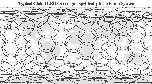
in multiple orbital planes, in varied inclined orbits. For instance,
the currently in-operation Iridium (Motorola) system, utilizes
66 satellites (plus six in-orbit spares) in six orbital planes
inclined at 86.4 degrees at an orbital height of 780km with an
orbital period of 100 minutes, 28 seconds. Global coverage with
this single system is an astounding 5.9 million square (statute)
miles/satellite. The radius of the footprint of a communications satellite
in LEO varies from 3000 to 4000 km. The maximum time during which
a satellite in LEO orbit is above the local horizon for an observer
on the earth is up to 20 minutes. (A satellite with an orbiting
altutude less than geostationary travels at a speed faster than
the earth's orbit.) Although there are long periods during which
the satellite is out of view of a particular ground station.
This may be acceptable for a store-and-forward type of communication
system as in an ecological/earth monitoring application. Most
small LEO systems employ polar, or near-polar, orbits. Accessibility
can of course be improved by deploying more than one satellite
and using multiple orbital planes. A complete global coverage
system using LEO orbits requires a large number of satellites,
in multiple orbital planes, in varied inclined orbits. For instance,
the currently in-operation Iridium (Motorola) system, utilizes
66 satellites (plus six in-orbit spares) in six orbital planes
inclined at 86.4 degrees at an orbital height of 780km with an
orbital period of 100 minutes, 28 seconds. Global coverage with
this single system is an astounding 5.9 million square (statute)
miles/satellite.
The topology of a full service LEO-based communication network
is dynamic; the network must continually adapt to 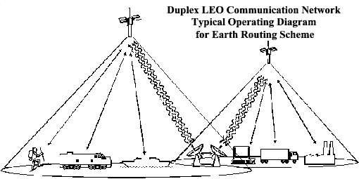 changing conditions to achieve the optimal (least
delay) connections between terminals. When a satellite serving
a particular user moves below the local horizon, it needs to
be able to hand over the service to a proximal or succeeding
one in the same or adjacent orbit. Depending on the system design,
individual satellites may cross-link with one another to relay
a signal typically via a rapid packet switching technique (as
in Iridium) or may return the signal to an earth terminal for
rerouting. changing conditions to achieve the optimal (least
delay) connections between terminals. When a satellite serving
a particular user moves below the local horizon, it needs to
be able to hand over the service to a proximal or succeeding
one in the same or adjacent orbit. Depending on the system design,
individual satellites may cross-link with one another to relay
a signal typically via a rapid packet switching technique (as
in Iridium) or may return the signal to an earth terminal for
rerouting.
You can see from the Iridium coverage map the enormity and complexity
of the global LEO communications task. Whether satellite-to-satellite
or satellite-earth terminal-satellite routing schemes are used,
messages are typically treated within a duplex (transmit and
 receive capability) LEO network as streams of short,
fixed length packets. Each packet contains a header that includes
destination address and sequence information, an error-control
section used to verify the integrity of the header, and a payload
section that carries the digitally encoded user data (voice,
video, data, etc.) and an adaptive packet routing algorithm to
achieve low delay and low delay variability across the network.
Each node (satellite or earth terminal) automatically and independently
selects the least delay route to the target destination. Packets
of the same user session may follow different paths through the
network. The terminal at the destination buffers and if necessary
reorders the received packets to eliminate the effect of timing
variations. receive capability) LEO network as streams of short,
fixed length packets. Each packet contains a header that includes
destination address and sequence information, an error-control
section used to verify the integrity of the header, and a payload
section that carries the digitally encoded user data (voice,
video, data, etc.) and an adaptive packet routing algorithm to
achieve low delay and low delay variability across the network.
Each node (satellite or earth terminal) automatically and independently
selects the least delay route to the target destination. Packets
of the same user session may follow different paths through the
network. The terminal at the destination buffers and if necessary
reorders the received packets to eliminate the effect of timing
variations.
Due to the relatively large movement of a satellite in LEO with
respect to an observer on the earth, satellite systems using
this type of orbit need to be able to cope with large Doppler
shifts. (The Doppler affect is commonly heard when a train pass
by you when you are by a railway crossing.) Satellites in LEO
are also affected by atmospheric drag which causes the orbit
to gradually deteriorate; the typical life of a LEO satellite
is 5-8 years. However, launches into low earth orbit are much
less costly than to geo orbit and due to their much lighter weight,
multiple LEO satellites can be launched at one time whereas only
two geo satellites can be launched at one time with today's best
heavy rocket technology.
The beauty of a LEO personal communication system is it provides
a direct satellite link for both incoming 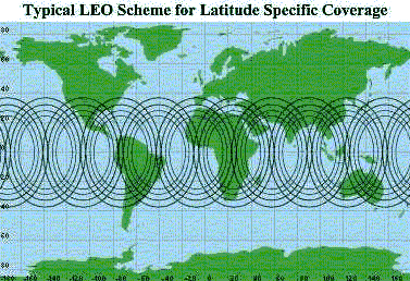 and outgoing communications in remote areas, poorly
covered regions, and locations outside terrestrial networks whether
it be with a hand held unit, from any public telephone in the
world, or simply through a unidirectional alpha numeric pager.
And it allows the user to bypass, i.e. 'roam', across multiple
wireless and national telephone systems using a single telephone
number and receiving one telephone bill for calls made anywhere
on earth. However, not all LEO personal communications schemes
aim at global coverage. Some current LEO proposals market only
to specific global latitudes where high density potential market
centers are located and others will remain more regional by offering
service to limited geographical and market segments. and outgoing communications in remote areas, poorly
covered regions, and locations outside terrestrial networks whether
it be with a hand held unit, from any public telephone in the
world, or simply through a unidirectional alpha numeric pager.
And it allows the user to bypass, i.e. 'roam', across multiple
wireless and national telephone systems using a single telephone
number and receiving one telephone bill for calls made anywhere
on earth. However, not all LEO personal communications schemes
aim at global coverage. Some current LEO proposals market only
to specific global latitudes where high density potential market
centers are located and others will remain more regional by offering
service to limited geographical and market segments.
Early regional, i.e. not global, LEO systems were designed to
offer remote monitoring and information transfer to national
trucking companies and mobile units. Using a vehicle, or desktop
mounted transceiver 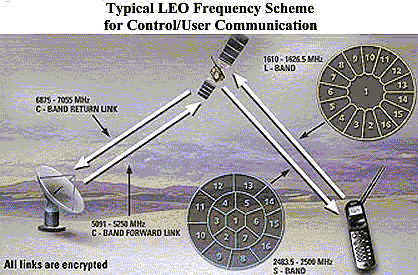 with a short, flexible antenna, the system is capable
to send and receive two-way alphanumeric information packets,
similar to two-way paging or e-mail. These systems have been
expanded to include hand held devices for personal messaging
for individual users. The sender's message goes to the nearest
in-view satellite where it is linked to the local earth station
gateway for validation and optimal routing to the recipient's
transceiver unit. (Satellite-earth terminal-satellite transfer
method.) If necessary, gateway earth stations relay messages
between satellites for faster delivery. Transmitted information
packets can also be frequency encoded for security and for user
uniqueness identification. This type routing is not as glorious
as satellite-to-satellite technology and relies on a combination
of microwave systems in its communication scheme but is very
efficient for the application. Although the 'big' LEO global
schemes currently in place, or in proposal, receive much more
attention than the 'little' LEO schemes, these less intricate
LEO schemes have been in place for quite a few years and have
made the trucking industry much more efficient and have also
had the extra affect to add a safety factor to its drivers by
providing a method to always be in contact with the main base. with a short, flexible antenna, the system is capable
to send and receive two-way alphanumeric information packets,
similar to two-way paging or e-mail. These systems have been
expanded to include hand held devices for personal messaging
for individual users. The sender's message goes to the nearest
in-view satellite where it is linked to the local earth station
gateway for validation and optimal routing to the recipient's
transceiver unit. (Satellite-earth terminal-satellite transfer
method.) If necessary, gateway earth stations relay messages
between satellites for faster delivery. Transmitted information
packets can also be frequency encoded for security and for user
uniqueness identification. This type routing is not as glorious
as satellite-to-satellite technology and relies on a combination
of microwave systems in its communication scheme but is very
efficient for the application. Although the 'big' LEO global
schemes currently in place, or in proposal, receive much more
attention than the 'little' LEO schemes, these less intricate
LEO schemes have been in place for quite a few years and have
made the trucking industry much more efficient and have also
had the extra affect to add a safety factor to its drivers by
providing a method to always be in contact with the main base.
Regardless of the target market, with vast tracts of the world
covered by desert, rugged mountain ranges and impenetrable jungles
and with over two thirds of the world covered by water, the value
and practicability of all types of LEO communications systems
will be increasingly recognized as we enter the twenty-first
century. Although geostationary satellites have the advantage
over LEO satellites of providing more frequent images per target
area and provide a permanent two-way communications link, the
era of disposable, light weight satellites as used in LEO systems
is upon us and here to stay. (top
of page)
Intermediate Circular Orbits (ICO), or Medium
Earth Orbits (MEO): ICOs are circular orbits at an altitude
of around 10,000 km. Their orbit period measures about 6 hours.
The maximum time during which a satellite in MEO orbit is above
the local horizon for an observer on the earth is in the order
of a few hours. A 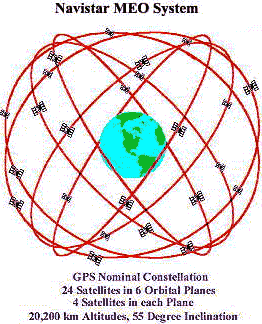 global communications system using this type of orbit,
requires a modest number of satellites in 2 to 3 orbital planes
to achieve global coverage. ICO satellite are operated in a similar
way to LEO systems. However, compared to a LEO system, transfer
of information from one satellite to another is less frequent,
and propagation delay and free space loss are greater. global communications system using this type of orbit,
requires a modest number of satellites in 2 to 3 orbital planes
to achieve global coverage. ICO satellite are operated in a similar
way to LEO systems. However, compared to a LEO system, transfer
of information from one satellite to another is less frequent,
and propagation delay and free space loss are greater.
The United States Navistar Global Positioning System (GPS) is
a prime example of a MEO system. It is a space-based triangulation
system using satellites and computers to measure positions anywhere
on earth. GPS is a radio navigation
system developed and operated by the U.S. Department of
Defense. It allows land, sea, and airborne users to determine
their three dimensional position, velocity, and time, 24 hours
a day, in all weather, anywhere in the world. The uniqueness
of this navigational system is that it avoids the limitations
of other land-based systems such as limited geographic coverage,
lack of continuous 24-hour coverage, and the limited accuracies
of other related navigational instruments.
Each satellite (twenty-one active plus three spares) weighs 844
kilograms and has a design life of 7.5 years and is about the
size of a large van with 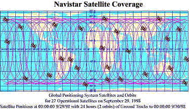 each solar panel covering a surface area of 7.2square
metres. They contain two rubidium and two cesium atomic clocks,
and three nickel cadmium batteries which provide energy during
eclipse periods. The satellites operate in six orbital planes
(55 degrees to the equator) with four satellites per plane and
have an orbital period of 12 hours such that they complete 2
orbital revolutions within a 24 hour period while the earth rotates
360 degrees. As typical of all LEO systems, this results in a
trace of the satellite orbit on the earth's surface which will
repeat itself regularly, in this case the repitition is daily.
Thus, the positions of the satellites in the sky at any location
can be defined for any particular period of time. each solar panel covering a surface area of 7.2square
metres. They contain two rubidium and two cesium atomic clocks,
and three nickel cadmium batteries which provide energy during
eclipse periods. The satellites operate in six orbital planes
(55 degrees to the equator) with four satellites per plane and
have an orbital period of 12 hours such that they complete 2
orbital revolutions within a 24 hour period while the earth rotates
360 degrees. As typical of all LEO systems, this results in a
trace of the satellite orbit on the earth's surface which will
repeat itself regularly, in this case the repitition is daily.
Thus, the positions of the satellites in the sky at any location
can be defined for any particular period of time.
Like most navigation systems, GPS receivers are hand-held radio-receivers/computers
which measure the time that the radio signal takes to travel
from a GPS satellite until it arrives at the GPS antenna to figure
location. Early on, scientists recognized the principle that,
given velocity and the time required for a radio signal to be
transmitted between two points, the distance between the two
points can be computed. In order to perform the calculation,
a precise, synchronized time of departure and measured time of
arrival of the radio signal must be obtained. By synchronizing
the signal transmission time to two precise clocks, one in a
satellite and one at a ground-based receiver, i.e. the handheld
unit, the transit (travel) time is measured and then multiplied
by the exact speed of light to obtain the distance between the
two positions. Using the travel time multiplied by the speed
of 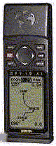  light provides a calculation of range to each satellite
in view; the satellites transmit on two L-band frequencies: L1
@1575.42 MHz and L2 @ 1227.6 MHz. Once distance from four satellites
is known, position in three dimensions (latitude, longitude,
and altitude) is calculated by triangulation, and velocity in
three dimensions is computed from Doppler shift in the received
signal. From this and additional information on the satellites'
orbit and velocity, the internal GPS receiver software calculates
its position through the process of triangulation. Standard
Positioning Service (SPS) Receivers are for civilian use
and are designed to track the 'coarse' acquisition code broadcast
by the satellites; they offer a
predicted accuracy of location within100 meters of true earth
position within a 340 nanoseconds transfer time from user
request to satellite system response. Precise Positioning
Service (PPS) is a highly accurate military positioning,
velocity and timing service that uses receivers designed to track
through the 'precise' code and which provides a predictable positioning
accuracy of at least 16 meters and time transfer within 200 nanoseconds.
(However, there are methods which can be use to provide accuracies
of +/- 5 metres. These methods use a known position, such as
surveyed control point, as a reference point to light provides a calculation of range to each satellite
in view; the satellites transmit on two L-band frequencies: L1
@1575.42 MHz and L2 @ 1227.6 MHz. Once distance from four satellites
is known, position in three dimensions (latitude, longitude,
and altitude) is calculated by triangulation, and velocity in
three dimensions is computed from Doppler shift in the received
signal. From this and additional information on the satellites'
orbit and velocity, the internal GPS receiver software calculates
its position through the process of triangulation. Standard
Positioning Service (SPS) Receivers are for civilian use
and are designed to track the 'coarse' acquisition code broadcast
by the satellites; they offer a
predicted accuracy of location within100 meters of true earth
position within a 340 nanoseconds transfer time from user
request to satellite system response. Precise Positioning
Service (PPS) is a highly accurate military positioning,
velocity and timing service that uses receivers designed to track
through the 'precise' code and which provides a predictable positioning
accuracy of at least 16 meters and time transfer within 200 nanoseconds.
(However, there are methods which can be use to provide accuracies
of +/- 5 metres. These methods use a known position, such as
surveyed control point, as a reference point to 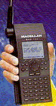 correct the GPS position error. These methods of correcting
GPS positions are referred to as Differential GPS or DGPS. DGPS
places a GPS stationary receiver at a known location on or near
the Earth's surface. This reference station receives satellite
signals and adjusts for transmission delays and selective availability,
using its own known latitude, longitude, and altitude. The stationary
receiver sends out a correction message for any suitably-equipped
local receiver. A DGPS-compatible receiver adjusts its position
calculations using the correction message. DGPS reference stations
are constructed, operated, and maintained by the United States
Coast Guard. The DGPS corrections can be applied to GPS data
in real-time using data telemetry (radio modems) or can be done
later on a personal computer.) PPS was designed primarily for
United States military use and is denied to unauthorized users
by the use of cryptography. However, PPS is being made available correct the GPS position error. These methods of correcting
GPS positions are referred to as Differential GPS or DGPS. DGPS
places a GPS stationary receiver at a known location on or near
the Earth's surface. This reference station receives satellite
signals and adjusts for transmission delays and selective availability,
using its own known latitude, longitude, and altitude. The stationary
receiver sends out a correction message for any suitably-equipped
local receiver. A DGPS-compatible receiver adjusts its position
calculations using the correction message. DGPS reference stations
are constructed, operated, and maintained by the United States
Coast Guard. The DGPS corrections can be applied to GPS data
in real-time using data telemetry (radio modems) or can be done
later on a personal computer.) PPS was designed primarily for
United States military use and is denied to unauthorized users
by the use of cryptography. However, PPS is being made available
 to U.S. federal government users including the foresty
service and for limited, non federal government, civil use, both
domestic and foreign, on an application basis. Receiver units
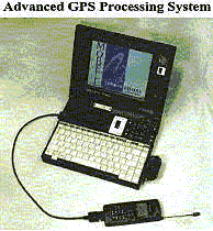
are available from numerous vendors (three are shown in this
section) each with a variety of user convenience features. Prices
typically range from several hundred USD to $30,000, reflecting
the accuracy and capabilities of the instruments. For the general
outdoorsman, a good GPS receiver should have 8 satellite tracking
capability and be capable of receiving the GPS satellite signals
through heavy forest canopy; for the professional user, a minimum
8 satellite tracking capability, high memory capacity, differential
GPS to U.S. federal government users including the foresty
service and for limited, non federal government, civil use, both
domestic and foreign, on an application basis. Receiver units
are available from numerous vendors (three are shown in this
section) each with a variety of user convenience features. Prices
typically range from several hundred USD to $30,000, reflecting
the accuracy and capabilities of the instruments. For the general
outdoorsman, a good GPS receiver should have 8 satellite tracking
capability and be capable of receiving the GPS satellite signals
through heavy forest canopy; for the professional user, a minimum
8 satellite tracking capability, high memory capacity, differential
GPS 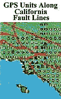 capability,
and resistance to signal dampening under forest canopy is essential;
for the professional surveyor requiring high level precision
and accuracy capability, they should assess the project or application
for which the technology is to be used with the help of an unbiased
consultant to determine the most cost effective and appropriate
instrument. GPS is an excellent tool for survey purposes and
if you plan to climb Mt. Everest then apply for PPS authorization.
A unique GPS PPS application is the NASA Southern
California Earthquake Project where GPS units are permanently
emplaced to detect earth movement and to hopefully be useful
in earthquake prevention. Private sector GPS LEO/MEO satellite
systems have been proposed which would provide PPS or greater
accuracy to the individual consumer though they are several years
from reality; the Navistar system is currently the only 'game
in town'. gps
technical info capability,
and resistance to signal dampening under forest canopy is essential;
for the professional surveyor requiring high level precision
and accuracy capability, they should assess the project or application
for which the technology is to be used with the help of an unbiased
consultant to determine the most cost effective and appropriate
instrument. GPS is an excellent tool for survey purposes and
if you plan to climb Mt. Everest then apply for PPS authorization.
A unique GPS PPS application is the NASA Southern
California Earthquake Project where GPS units are permanently
emplaced to detect earth movement and to hopefully be useful
in earthquake prevention. Private sector GPS LEO/MEO satellite
systems have been proposed which would provide PPS or greater
accuracy to the individual consumer though they are several years
from reality; the Navistar system is currently the only 'game
in town'. gps
technical info
(top of page)
Highly Elliptical Orbits (HEO): HEO orbits for earth applications were
initially exploited by the  Russians to provide communications to their northern
regions not in coverage by their geo satellite networks. HEOs
typically have a perigee at about 500 km above the surface of
the earth and an apogee as high as 50,000 km. The orbits are
inclined at 63.4 degrees in order to provide communications services
to locations at high northern latitudes. The particular inclination
value is selected in order to avoid rotation of the apses, i.e.
the intersection of a line from earth centre to apogee, and the
earth surface will always occur at a latitude of 63.4 degrees
North. Orbit period varies from eight to 24 hours. Owing to the
high eccentricity of the orbit, a satellite will spend about
two thirds of the orbital period near apogee, and during that
time it appears to be almost stationary for an observer on the
earth (this is referred to as apogee dwell). A well designed
HEO system places each apogee to correspond to a service area
of interest, i.e. which would cover a major population centre,
for example in the Russian
Molnya satellite system designed to cover Siberia. After
the apogee period of orbit, a switchover needs to occur to another
satellite in the same orbit in order to avoid loss of communications
to the user. Free space loss and propagation delay for this type
of orbit is comparable to that of geostationary satellites. However,
due to the relatively large movement of a satellite in HEO with
respect to an observer on the earth, satellite systems using
this type of orbit need to be able to cope with large Doppler
shifts. Examples of HEO systems are the Russian Molnya
system, which employs 3 satellites in three12 hour orbits separated
by 120 degrees around the earth, with apogee distance at 39,354
km and perigee at 1000 km and the Russian Tundra system, which
employs 2 satellites in two 24 hour orbits separated by 180 degrees
around the earth, with apogee distance at 53,622 km and perigee
at 17,951 km. Russians to provide communications to their northern
regions not in coverage by their geo satellite networks. HEOs
typically have a perigee at about 500 km above the surface of
the earth and an apogee as high as 50,000 km. The orbits are
inclined at 63.4 degrees in order to provide communications services
to locations at high northern latitudes. The particular inclination
value is selected in order to avoid rotation of the apses, i.e.
the intersection of a line from earth centre to apogee, and the
earth surface will always occur at a latitude of 63.4 degrees
North. Orbit period varies from eight to 24 hours. Owing to the
high eccentricity of the orbit, a satellite will spend about
two thirds of the orbital period near apogee, and during that
time it appears to be almost stationary for an observer on the
earth (this is referred to as apogee dwell). A well designed
HEO system places each apogee to correspond to a service area
of interest, i.e. which would cover a major population centre,
for example in the Russian
Molnya satellite system designed to cover Siberia. After
the apogee period of orbit, a switchover needs to occur to another
satellite in the same orbit in order to avoid loss of communications
to the user. Free space loss and propagation delay for this type
of orbit is comparable to that of geostationary satellites. However,
due to the relatively large movement of a satellite in HEO with
respect to an observer on the earth, satellite systems using
this type of orbit need to be able to cope with large Doppler
shifts. Examples of HEO systems are the Russian Molnya
system, which employs 3 satellites in three12 hour orbits separated
by 120 degrees around the earth, with apogee distance at 39,354
km and perigee at 1000 km and the Russian Tundra system, which
employs 2 satellites in two 24 hour orbits separated by 180 degrees
around the earth, with apogee distance at 53,622 km and perigee
at 17,951 km.
(top of page)
Sun-Synchronous Orbit: This
orbit is a special case of the polar orbit (which is a special
coordinated LEO orbit). In a sun-synchronous (SS) orbit, (also
called a  helio-synchronous orbit), the satellite passes over
the same part of the earth at roughly the same local time each
day. This can make communication and various forms of data collection
very convenient. For example, a satellite in an SS orbit could
measure the air quality of Ottawa, Canada, at noon each and every
day. In an SS orbit the angle between the orbital plane and sun
remains constant, i.e. a constant node-to-sun angle, and therefor
the satellite passage over a certain area occurs at the same
time of the day each day. This can be achieved by a careful selection
of orbital height, eccentricity and inclination which produces
a precession of the orbit (node rotation) of approximately one
degree eastward each day, equal to the apparent motion of the
sun. This condition can only be achieved for a satellite in a
retrograde orbit. Like any polar orbit, the earth moves beneath
an SS orbit. A satellite in SS orbit crosses the equator and
each latitude at the same time each day. All sun-synchronous
orbits are polar orbits but not all polar orbits are sun-synchronous
orbits. All polar orbits are LEO/MEO orbits. helio-synchronous orbit), the satellite passes over
the same part of the earth at roughly the same local time each
day. This can make communication and various forms of data collection
very convenient. For example, a satellite in an SS orbit could
measure the air quality of Ottawa, Canada, at noon each and every
day. In an SS orbit the angle between the orbital plane and sun
remains constant, i.e. a constant node-to-sun angle, and therefor
the satellite passage over a certain area occurs at the same
time of the day each day. This can be achieved by a careful selection
of orbital height, eccentricity and inclination which produces
a precession of the orbit (node rotation) of approximately one
degree eastward each day, equal to the apparent motion of the
sun. This condition can only be achieved for a satellite in a
retrograde orbit. Like any polar orbit, the earth moves beneath
an SS orbit. A satellite in SS orbit crosses the equator and
each latitude at the same time each day. All sun-synchronous
orbits are polar orbits but not all polar orbits are sun-synchronous
orbits. All polar orbits are LEO/MEO orbits.
A special SS orbit, called a dawn-to-dusk orbit, is where the
satellite trails the Earth's shadow. When the sun shines on one
side of the Earth, it casts a shadow on the opposite side of
the Earth - this shadow is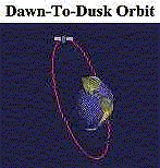 night-time. Because the satellite never moves into
this shadow, the sun's light is always on it, i.e. like perpetual
daytime. Since the satellite is close to the shadow, the part
of the earth the satellite is directly above is always at sunset
or sunrise; that is why this kind of orbit is called a dawn-dusk
orbit. A dawn-dusk orbit allows the satellite to always have
its solar panels in the sun. Radarsat is an example of a satellite
in a low sun synchronous orbit. Radarsat is in orbit 798 kilometres
above the Earth, at an angle of inclination of 98.6 degrees to
the equator as it circles the globe from north pole to south
pole. Radarsat relies on its dawn-to-dusk orbit to keep its solar
panels facing the sun almost constantly. Radarsat can therefore
rely mostly on solar power and not on batteries; its images are
useful for agriculture, oceanography, forestry, hydrology, geology,
cartography, and meteorology. night-time. Because the satellite never moves into
this shadow, the sun's light is always on it, i.e. like perpetual
daytime. Since the satellite is close to the shadow, the part
of the earth the satellite is directly above is always at sunset
or sunrise; that is why this kind of orbit is called a dawn-dusk
orbit. A dawn-dusk orbit allows the satellite to always have
its solar panels in the sun. Radarsat is an example of a satellite
in a low sun synchronous orbit. Radarsat is in orbit 798 kilometres
above the Earth, at an angle of inclination of 98.6 degrees to
the equator as it circles the globe from north pole to south
pole. Radarsat relies on its dawn-to-dusk orbit to keep its solar
panels facing the sun almost constantly. Radarsat can therefore
rely mostly on solar power and not on batteries; its images are
useful for agriculture, oceanography, forestry, hydrology, geology,
cartography, and meteorology.
An SS low altitude polar orbit is widely used for monitoring
the Earth because each day, as the Earth rotates below it, the
entire surface is covered and satellite views the same earth
location at the same time each 24hr. period. Typically such a
satellite moves at an altitude of 1000 km (some go lower but
don't last long, because of air friction, each orbit takes about
100 minutes, and scans a path that is about 110 degrees width,
about a surface distance roughly of 3000 km. Of course this type
of orbit is advantageous for an earth observation satellite as
it can provide constant lighting conditions; but also for detection
applications as in search and rescue programs, as it allows regular
monitoring of the same location from the same satellite. An example
of a sun-synchronous search and rescue system is the Cospas-Sarsat
network system.
Cospas-Sarsat is an international, humanitarian system that uses
near polar orbiting satellites to detect and 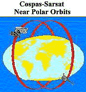 locate emergency beacons carried by ships, aircraft,
or individuals. The system consists of a network of satellites,
ground stations, mission control centers, and rescue coordination
centers. Acting as communication relays, the Cospas-Sarsat satellites
receive radio distress signals from emergency transmitting beacon
units. The nominal system configuration comprises four satellites,
two Cospas and two Sarsat. Russia supplies two Cospas satellites
placed in near polar orbits at 1000 km altitude and equipped
with SAR (search and rescue) instrumentation at 121.5 MHz and
406 MHz. The USA supplies two NOAA meteorological Sarsat satellites
placed in SS, near-polar orbits at about 850 km altitude, and
equipped with SAR instrumentation at 121.5 MHz, 243 MHz, and
406 MHz supplied by Canada and France. locate emergency beacons carried by ships, aircraft,
or individuals. The system consists of a network of satellites,
ground stations, mission control centers, and rescue coordination
centers. Acting as communication relays, the Cospas-Sarsat satellites
receive radio distress signals from emergency transmitting beacon
units. The nominal system configuration comprises four satellites,
two Cospas and two Sarsat. Russia supplies two Cospas satellites
placed in near polar orbits at 1000 km altitude and equipped
with SAR (search and rescue) instrumentation at 121.5 MHz and
406 MHz. The USA supplies two NOAA meteorological Sarsat satellites
placed in SS, near-polar orbits at about 850 km altitude, and
equipped with SAR instrumentation at 121.5 MHz, 243 MHz, and
406 MHz supplied by Canada and France.
SARSAT is an instrument package flown board the NOAA Series of
environmental satellites operated by
NOAA's National Environmental Satellite, Data and Information
Service (NESDIS). These SS satellites 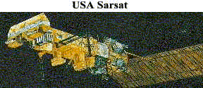 orbit at an altitude of 528 miles and complete an
orbit every 100 minutes. Their orbits are inclined 99 degrees
from the equator. Each satellite carries a Search and Rescue
Repeater (SARR) which receives and retransmits 121.5 MHz and
243 MHz signals anytime the satellite is in view of a ground
station. Also carried is a Search and Rescue Processor (SARP)
which receives 406 MHz transmissions, provides measurements of
the frequency and time, then retransmits this data in real-time
and stores it aboard for later transmission. orbit at an altitude of 528 miles and complete an
orbit every 100 minutes. Their orbits are inclined 99 degrees
from the equator. Each satellite carries a Search and Rescue
Repeater (SARR) which receives and retransmits 121.5 MHz and
243 MHz signals anytime the satellite is in view of a ground
station. Also carried is a Search and Rescue Processor (SARP)
which receives 406 MHz transmissions, provides measurements of
the frequency and time, then retransmits this data in real-time
and stores it aboard for later transmission.
The Cospas instrument is carried aboard the Nadezhda navigation
satellite orbiting the Earth every 105 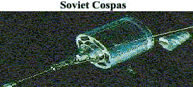 minutes at an altitude of 620 miles and an orbital
inclination of 83 degrees. The COSPAS instrument was built by
the former Soviet Union and continues to be operated by the Russian
Federation. The only major difference between Cospas and Sarsat
is that Russian satellites do not monitor the 243 MHz distress
signals which is the NATO distress frequency. Both systems operate
and process received signals to ground stations in similar manner
- each satellite makes a complete orbit of the earth around the
poles in about 100 minutes, travelling at a velocity of 7 km
per second; each satellite views a "swath" of the earth
over 4000 km wide as it circles the globe, giving an instantaneous
"field of view" about the size of a continent; each
satellite, when viewed from earth, crosses the sky in about 15
minutes, depending on the maximum elevation angle of the particular
pass, but only the Sarsat system is inclined appropriately to
be sun synchronous. minutes at an altitude of 620 miles and an orbital
inclination of 83 degrees. The COSPAS instrument was built by
the former Soviet Union and continues to be operated by the Russian
Federation. The only major difference between Cospas and Sarsat
is that Russian satellites do not monitor the 243 MHz distress
signals which is the NATO distress frequency. Both systems operate
and process received signals to ground stations in similar manner
- each satellite makes a complete orbit of the earth around the
poles in about 100 minutes, travelling at a velocity of 7 km
per second; each satellite views a "swath" of the earth
over 4000 km wide as it circles the globe, giving an instantaneous
"field of view" about the size of a continent; each
satellite, when viewed from earth, crosses the sky in about 15
minutes, depending on the maximum elevation angle of the particular
pass, but only the Sarsat system is inclined appropriately to
be sun synchronous.
These satellites use Doppler to locate emergency beacons. Doppler
is the increase in pitch of the frequency as the satellite approaches
the emergency beacon and then the sudden decrease in pitch as
the satellite moves away from the beacon. (The Doppler affect
is commonly heard when a train pass by you when you are by a
railway crossing.). Acting as communication relays, the Cospas-Sarsat
satellites 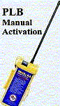 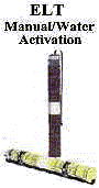 receive radio receive radio  distress signals from marine Emergency Position Indicating
Radio Beacons (EPIRBs), and aircraft Emergency Locator Transmitters
(ELTs) and Personal Locator Beacons (PLBs). The satellites re-transmit
distress information to ground stations called Local User Terminals
(LUTs) which process the signal and calculates the position
from which it originated. The satellite also stores each signal
it receives and continuously downloads this data. If the satellite
is in view of a ground station when a 406 MHz signal is received
the data is transmitted to the ground station in distress signals from marine Emergency Position Indicating
Radio Beacons (EPIRBs), and aircraft Emergency Locator Transmitters
(ELTs) and Personal Locator Beacons (PLBs). The satellites re-transmit
distress information to ground stations called Local User Terminals
(LUTs) which process the signal and calculates the position
from which it originated. The satellite also stores each signal
it receives and continuously downloads this data. If the satellite
is in view of a ground station when a 406 MHz signal is received
the data is transmitted to the ground station in 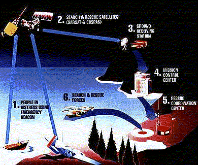 real-time.
If the satellite was not in view of a ground station, and for
the other detected frequencies, when it receives a beacon signal,
the next ground station that sees that satellite will receive
the data. The LUT then relays the information to national Mission
Control Centres (MCCs) where it is joined with identification
data and other information on that beacon who in turn pass location
data and other pertinent information to the appropriate Rescue
Coordination Centres (RCCs) based on the geographic location
of the beacon. If the location of the beacon is in another country's
area of responsibility, then the alert is transmitted to that
country's mission control center. Locations can be pinpointed
in as little as forty minutes from time of beacon activation.
The 406MHZ frequency is much more stable than its 121.5MHz counterpart
and is therefore able to give a much more accurate location of
about 1 to 5 km. The 121.5/243MHz beacons average 25 km accuracy.
Because the satellites are near polar orbiting, coverage is better
near the poles and less near the equator (as the earth 'bulges',
i.e. near the equator, the satellite coverage path is not as
inclusive). real-time.
If the satellite was not in view of a ground station, and for
the other detected frequencies, when it receives a beacon signal,
the next ground station that sees that satellite will receive
the data. The LUT then relays the information to national Mission
Control Centres (MCCs) where it is joined with identification
data and other information on that beacon who in turn pass location
data and other pertinent information to the appropriate Rescue
Coordination Centres (RCCs) based on the geographic location
of the beacon. If the location of the beacon is in another country's
area of responsibility, then the alert is transmitted to that
country's mission control center. Locations can be pinpointed
in as little as forty minutes from time of beacon activation.
The 406MHZ frequency is much more stable than its 121.5MHz counterpart
and is therefore able to give a much more accurate location of
about 1 to 5 km. The 121.5/243MHz beacons average 25 km accuracy.
Because the satellites are near polar orbiting, coverage is better
near the poles and less near the equator (as the earth 'bulges',
i.e. near the equator, the satellite coverage path is not as
inclusive).
The speed and accuracy of this communications process significantly
increases the accident victim's ultimate chance for survival.
This provides global coverage for 121.5/406 MHz distress signals
though not all regions of the world have installed appropriate
receive and process ground stations therefore only 60% of the
earth's 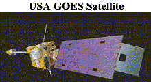 surface is actually currently being served by Cospas-Sarsat.
To provide another option for global coverage, NOAA Geosychronous
Operational Environmental Satellites (GOES 8 and 10, 9 is an
in-orbit spare) geo satellites have been interconnected to the
Cospas-Sarsat receive and process ground stations. They provide
near instantaneous 406MHz beacon detection to allow more rapid
preparation for response but do not give a Doppler position. surface is actually currently being served by Cospas-Sarsat.
To provide another option for global coverage, NOAA Geosychronous
Operational Environmental Satellites (GOES 8 and 10, 9 is an
in-orbit spare) geo satellites have been interconnected to the
Cospas-Sarsat receive and process ground stations. They provide
near instantaneous 406MHz beacon detection to allow more rapid
preparation for response but do not give a Doppler position.
Summary: If there was to be a summary
to this page on satellite orbits, by combining the benefits of
polar LEO orbits, sun-synchronous orbits and the recently integrated
geo orbit, the Cospas-Sarsat system, which provides a tremendous
resource for protecting the lives of aviators and mariners that
was unthinkable prior to the Space-Age, shows us that all types
of earth satellite orbits are important in their own way. The
Cospas-Sarsat system uses multiple orbit types to its advantage
to create its user application. Constant and new advances in
microcircuitry and computer technology will allow a continueing
of imagination for applications of satellites in orbit to become
reality. As long as there is a perceived notion that advances
in communications and improvements in global environmental monitoring
are good for industry, society and mankind, then financing will
be available for new satellite systems and new applications and
we can expect to see satellites play an increasing role in our
world. (top of page) |
|