This trip has been made possible by Mainland Great Outdoors in Christchurch, New Zealand, Fairydown, One Planet, and Karhu skis.
Kosciuszko
Sea to summit
"AUSTRALIA? But there aren't any mountains there.''
That was a typically Kiwi response to news that my fourth sea to summit trip was going to be in Australia. The other typically Kiwi response was to give up on attempting to pronounce or spell the country's highest peak, Kosciuszko, and dub it Quasimodo instead.
There were justifications for either response, since the Big K stands at a mere 2228m above sea level, features a car park little more than a kangaroo's hop from the summit, and is located in a country better known for its deserts than its skifields. When it comes to the spelling, it took the Australians over 140 years to get it right by adding the "Z", so newcomers can be excused for grappling with it. As for the Quasimodo bit, the summit massif does look a little hunchbacked...
By Kiwi standards there might not be any mountains there but there proved to be a bloody lot of hills and an even greater amount of snow, since my intended route linking the southernmost and highest points of the Australian mainland via effectively the line of most resistance along the grandly-named Australian Alps Walking Track and was taking place in the snowiest winter Australia had enjoyed for decades.
I'd done bits of this route before in the 1980s when I was living in Melbourne and had been up Kosciusko twice back in the pre-Z days before they decided that, if they were going to name the highest peak because it looked like the burial mound in Krakow of a famous Polish patriot, they ought at least spell it correctly. With or without the Z, it was a special place.
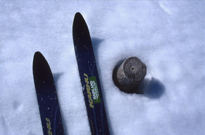
This trip began with the realisation that after many many weekends of close encounters with every form of thorny or spiked vegetation in the New Zealand back-country, my gear was due for a major upgrade. I was spared a mortgage-busting reinvestment by Gerry Hassan of Mainland Great Outdoors Centre in Christchurch, who responded to my begging letter espousing the sea to summit philosophy by organising One Planet to chip in a new Gore-tex jacket and Fairydown to provide a new Quallofill sleeping. This fine gentleman also provided a host of other stuff at mate's rates. I made entreaties about his investment being reciprocated by writing about the trip here and elsewhere but I suspect what swung him was that sea to summit was a trip he'd have liked to have done himself. Karhu also came to the party, with a wholesale price pair of Catamount cross country Telemark skis, which were short, fat, ideal for the ugly back country stuff, and - during the snowy bits of the trip - the subject of many jealous looks.
I added to this site by e-mail during the journey (thanks to computer buff and tramping colleague Paul Ashton) but rather than meld the reports into one story, I've left them as they were except to change the more obvious grammatical, typing, or stylistic deficiencies.
Day: 4.
Location: Burger bar and cyber-caf� in Foster, Victoria.
Kilometres: 75.
Total height gain: 950m.
Number of unsolicited offers of lifts: 3.
Days since decent coffee: 4
Days since any coffee: 0
Approximate percentage of people who understand what this trip is about: 50
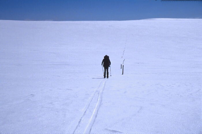
After three days of walking, I�m currently a grand total of 10km from the sea, so I could have started just near here and still had relatively pain-free feet. The theory of starting from South Point on Wilson's Promontory - that it would link the southernmost and highest parts of the mainland - had sounded great in the pub but after three days of walking, it was a little depressing to be so sore and still so close to the sea.
At least "The Prom", as it's universally known in these parts, was a wonderful place to start and, for company, I had Graham, my climbing companion on Cook, who had moved from Nottingham in the UK to Melbourne a few months before. With the surname of Holden and a fondness in Britain for Vauxhalls, it was no surprise that he had bought one of his namesakes for transport. And not just any Holden but the Mighty HQ � a 1974, V8, one-owner piece of Australian automotive history � which took us to Tidal River to do what I�d billed as an easy, packless out-and-back day to South Point, the southernmost point of the Australian mainland.
Graham, of course, was a veteran of my last professed easy, packless, out-and-back trip to the mouth of the Karangarua River on New Zealand�s wild west coast. Having survived that, er, adventure, he checked up on the ease of this one and found that it wasn�t all that easy. So it proved to be as we followed about 19km of walking- and four-wheel-drive tracks from Tidal River to South Point, where some awkward rockclimbing moves on truly wonderful granite took us as far south as it's possible to get without water wins, after which we staged a bit of a photofest then retraced our steps for another 19km back to Tidal River. Having left Melbourne over an hour before dawn, we arrived back in Tidal River after dark and within 15 minutes, the tent was up and I was inside snoring.
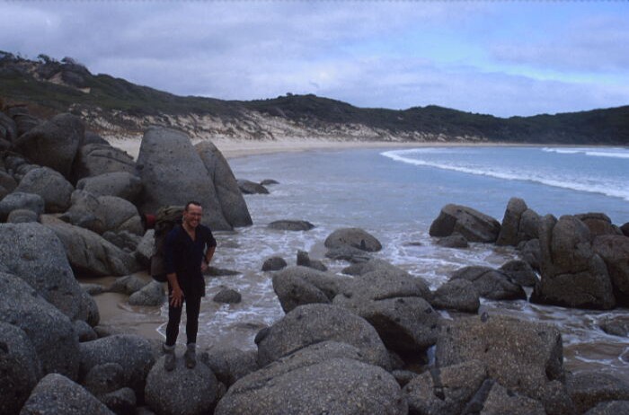
On the second day, we followed the coastal track over headlands and along wonderful beaches to Whisky Bay - scene of the photo above - at which point Graham headed back to the car to drop food, skis and equipment at Walhalla and I walked up a couple of kilometres of road to the next bit of track to Darby River. From there, the mode changed to bare feet walking along the beach then along the Cotters Lake track and a 10km-ish walk along the main road to the park entrance. The first unsolicited offer of a lift came here from a couple who had obviously done a fair bit of bushwalking in their day. I declined, explained the trip, and suggested they take my pack to the park entrance. They were happy to do so and suggested that I ought to do Denali � from Tierra del Fuego! "This is hard enough," I replied then set off and arrived at the park entrance right on dark. I�d asked them to drop the pack at the ranger headquarters but they�d done enough walking (or sussed me out quickly enough) to realise the f***-up factor that could entail and suggested an if-the-ranger-station-is-shut plan. Inevitably, it was that planning which resulted in me finding my pack beside the closed ranger station!
Day three and it was serious road bashing. Seven kilometres to Yanakie, where the gallery and tea shop was closed for the season and I had to make do with a cup of instant coffee from the general store. That afternoon it was another 23km or so, mostly along the backroads, to Foster. Time for a shower, I thought, and booked into a backpackers. ``Come from far?�� the proprietor asked and I explained that I�d walked from the tip of the Prom, but not today, and was going to do Kosciuszko from sea to summit. Silence. I was the only one in the truly cheerless backpackers and the next morning she asked if I was catching the bus to Melbourne that day. I didn�t even bother trying to explain it.
Day four started with rain and a time to give my sore feet a break. The next obstacle (physically speaking, as opposed to the mentally questionable one of pursuing these sea to summit projects) is the Strzelecki Range between here and the La Trobe Valley to the north. As barriers go, this is rather fitting since it was Strzelecki who named (and presumably mis-spelt) Kosciuszko after his compatriot national hero. A vastly experienced bushwalking friend from Melbourne had built up the Strzeleckis into being something akin to the Himalaya and the Andes combined, which seemed a little unlikely. I�ll head off to do the first 10km or so of the Mighty Strzeleckis this afternoon and make the cheerily titled town of Mirboo North tomorrow, a goal rather more likely now that I heard that MN has it�s own brewery.
Update Two
Days: Eight
Kilometres: 181
Cumulative height gain: 2420m (Higher than Kosci!)
Number of unsolicited offers of lifts: 8.
Days since coffee: 0
Days since decent coffee: sorry to the baristas of Tidal River, Yanakie, Foster, Mirboo North, Moe, and Walhalla but the answer is eight.
Comments of open disbelief about my sea to summit trip: One.
Current location: Sunny Brisbane!
Day Four: From Foster, I was on the main road for a few kilometres then surged upwards into the Mighty Strzeleckis, about which I had been warned in dire terms. It didn't prove to be the case and was actually even enjoyable (by the standards of road walking anyway), including the unsolicited offer within 5km of not only a lift but also a bed for the night. Why couldn't I have met this person the previous evening and avoided the House of Gloom Backpackers? I'd left at the less than alpine hour of 3pm, thereby missing the rain which pelted down for most of the morning but not missing the hail which came in just on dusk at a time when I had to go to a farmhouse to get directions. When I asked where I was, the woman explained that I was in a "cold and wet part of South Gippsland'', which I'd pretty much figured out for myself. She then sent me in the right direction - which of course involved the route of most effort following the road winding down a gully and back out another.
Just as twilight began and I started looking for somewhere to doss or camp, the road headed down towards Turton Creek, which I thought would be a short patch of bush and back into farmland. As would be obvious to anyone who had been following the tenor of these trips, I was of course wrong and emerged after five or six kilometres through wonderful Eucalypt forests at the town (three houses, not near each other) of Turton Creek. The resident of the only house with a light on kindly let me kip in his woolshed, which was a good move since it hosed down overnight and saved me from having to carry a wet tent for the next few days.
Day Four had been supposed to be a rest day but involved 19km. What would Day Five entail? Over 40km, as it turned out, as I threaded a way through the memorably titled towns of Mirboo and Mirboo North (the latter being the self-proclaimed Capital of the Grand Ridge Road which goes along the spine of the Mighty Strzeleckis) and finally to the church at Narracan, where I kipped under the stars. The Fairydown synthetic sleeping bag proved its worth by exuding the sweat to the outside, where it froze into droplets of ice which were easily flicked off in the morning.
Day Six involved a 12km stroll through the hobby farmlets surrounding Moe, arriving in the bustling (not!) city centre around 10am for a late breakfast of good healthy food from the supermarket. Next stop was the library, where I booked an internet session to catch up on e-mails and weather forecasts. I had to show my passport to the librarian to get "visitor" access to the computers, which led to the inevitable question about where I was heading. I told them, which they noted without any reaction either way. Among the e-mails was a series between Graham and I in which we canned our original plan to go skiing at Baw Baw the following day. The complicating factor was that he had my alpine sleeping bag, which he was going to bring up to swap with the sub-alpine one I'd been using so far on the trip. A series of e-mails later, we arranged to send our respective bags to each other via the rail network, a potentially disastrous arrangement which strangely (for me) passed without a hitch. It did mean, though, that I had to stay in town until the 8pm train, so I spent the time surfing the web at the library and then reading through the magazine rack. Shortly before closing time, the librarian who I'd told earlier about the sea to summit Kosci trip came over, looked at me with my pile of magazines, and said: "You're not going to get to your mountain this way", in a tone of disbelief that my stated itinerary was based on reality! Once I had the sleeping bag, I walked about 7km out of town and found a side road to raise my tent for the night.
Day Seven started with a shock soon after midnight when a truck driver saw the tent in the bushes beside the road and thought I deserved a wake-up call via his air horn. At a more reasonable hour of 8am, I began to pack up when I noticed the screw holding one arm of my glasses was in the process of coming out. Good sense dictated moving into the tent in case I dropped the screw. Yeah, well, you know what happened next� After half an hour of searching through the leaf litter, I managed to replace the screw with a loop of plastic cord. The newly-wonky glasses, combined with the brutally-efficient skinhead haircut and a week of beard, meant all I needed was a tattered and underlined bible and my ''obsessive nutter'' look would have been complete.
The 25km slog along the road to Erica was eased early on by the seventh unsolicited offer of a lift of the trip. I gratefully declined the offer but asked him to transport my pack to the village's general store, where I arrived a little over four hours later, footsore and hungry, for a siesta. I'd been contemplating staying there the night since my feet were complaining about being confined and wet for the past week and I couldn't face the prospect of a further roadbash that evening. Then the proprietors of the store told me about the old railway line which used to run from Erica to Walhalla, and the prospect of progress which did not involve a road was so appealing that I headed off a little before 4pm. The route was a wee gem, traipsing through the bush at the rate of height gain you'd expect from a railway and I enjoyed it so much I walked all the way to Walhalla. This involved walking up the newly-reconstructed bit of railway from the bridge over the Thomson River, which was fine even when I was overtaken by darkness. My headtorch came out and I continued on, although anyone who watched my progress is probably now telling their story to the National Enquirer about seeing the ''ghost train'' to Walhalla in which you could see the train's headlight but nothing else� I reached about 1km from the town when the train line abruptly stopped and I found myself contemplating what appeared to be a vertical drop into the stream. The prospect of having to backtrack the whole way to Thomson Bridge loomed large, until closer examination showed a construction track leading down into the stream for the last bit of distance into Walhalla. In keeping with my appearance, I dossed on the platform of the train station, fairly confident in the knowledge that the next train was not due until - let me just check the timetable - May 2001.
Day eight involved a brutal walk of less than a kilometre to the Walhalla General Store, where proprietess Rhonda saw me and immediately said: ''I think I know who you are�'' Indeed she did. She'd rung Graham in Melbourne the previous evening because my estimate for arriving in Walhalla had been optimistic by a couple of days. Her self-appointed role, apart from making a killer breakfast, was to make everyone who completes the Australian Alps Walking Track feel like some kind of hero. She gave me the treatment and I hadn't even started it! In my view, most people would think walking 181km (or so) mostly along the road from the bottom of Wilson's Prom was a sign of mental instability rather than anything else. Over breakfast I was shown all the media clippings about Walhalla' recent rennaisance (population has increased from 13 to 23) and told about others who had been pursuing various goals when doing the walk. She said she'd asked Graham what my goals were and he' replied: ''� don't know, this is just how he spends his holidays". I felt like John Hillaby, who had written about his walk from Lands End to John O'Groats in Britain but said he lived in fear of being asked why he was doing it because he had never come up with a answer that sounded sensible. I suggested she look at this website.
By this point the blisters and athlete's foot (you really wanted to know that, didn't you?) which had been building up over the past week demanded a break, or at least threatened to take the shine off the trip, before I disappeared for the seven to 10 day burst to Mt Buller. Combined with what was dubbed ''the mother of all lows'' building in the Southern Ocean, I opted to take a few days off and hitched back to Melbourne (of course when I actually wanted a lift, hardly anyone stopped). From there, I took an overnight bus to Brisbane to indulge in some family bonding in a place which was warm, comfortable and didn't involve truck drivers providing impromptu midnight wake-up calls.
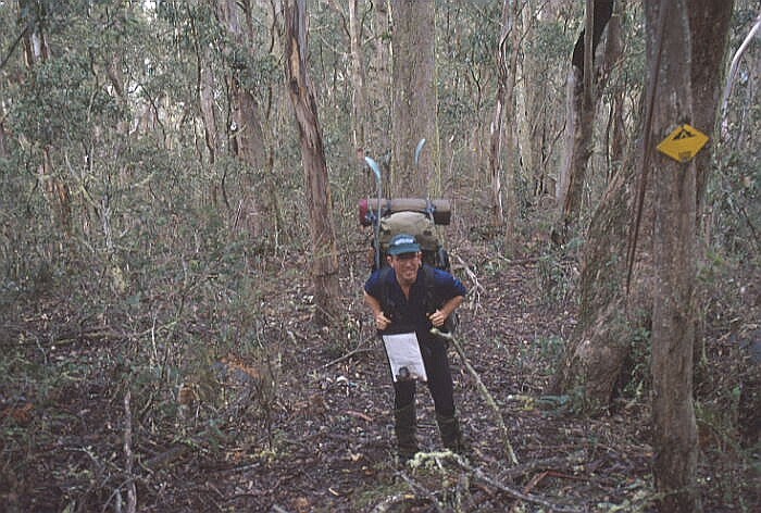
Through the bush above Red Jacket gold mine, AAWT marker on the tree.
Update: Three
Days: 17
Kilometres: 364km
Cumulative height gain: 8440m
Consecutive days without coffee of any kind: nine (a record?)
Ratio of time spent carrying skis to time actually spent skiing: 7:1
Stupidity index: 7:1
Walhalla was where the hard work was supposed to begin, which it did when I headed off a little before midday with what proved to be 12 days food in my pack, watched by about one quarter of the town's population (which amounted to five people and a dog). Luckily the hard bit only lasted for about 50m as the route climbed to the old tramway which then went gently downhill for the next 8km. I was able to fake the vigourousness for that short climb before relying on the downhill to appear fit and enthusiastic.
A few hours later, I was at 220m abs, the lowest point of the Australian Alps Walking Track and facing the track's biggest single height gain up to the Baw Baw plateau. In Chile, the 200km walk from the coast had made me ferociously fit by the time the big climbing on Aconcagua came about and I hoped the same would have happened here. It did, in a way, but nothing is that easy when you've carrying 27kg and ascending the best part of 1300m. I emerged onto the Mt Erica road right on dusk and in the rain but convinced myself to keep walking up the road for another 3km in the dark to the Erica car park, using the shameless bribe of letting myself sleep in to 8am the next morning.
The idea was that a higher base would allow me to get across the Baw Baws in a day, since it was one of the few sections of the trip which was weather dependent. I'd timed my arrival from Brisbane to co-incide with what looked like a weather window for the following day. As anyone has read this journal will be able to predict, that weather window was firmly shut by a storm all the next day which hosed down rain and kept me inside my increasingly soggy tent. The following day dawned brighter but by then everything was so damp that it was not so much a matter of breaking camp as weighing anchor (to borrow a WH Murray phrase). A few hours later I passed by Mushroom Rocks (and went past a cave which would have kept me dry, if I'd remembered it from my last visit 11 years earlier) and finally found some snow at about 1350m. I was finally on skis, although oddly enough the pack didn't feel any lighter without them on board. The weather wasn't perfect though, with about 200m visibility and occasional dustings of sleet and snow, which within a few hundred metres of leaving Talbot Peak had me heading in due south when I should have been going north. Time to apply some proper navigation, which with the altimetre was difficult but achieveable, albeit at a glacial pace of about one kilometre an hour because of the reasonably featureless terrain. Of course the weather improved just as I got to the snow-poled route between Baw Baw and St Gwinear then deteriorated again when I headed off again through the snowgums towards Mt Whitelaw.
This had been the venue for my first day on cross country skis back in 1987 and I remember how as tiredness crept in over the afternoon, every granite tor looked like a hut. It was the same here as after over nine hours on the go, I came across a rock which looked just like a chimney. Closer examination showed it was a chimney, from the old Whitelaw hut which had been destroyed back in the 1920s or 30s. I kept going but cocked up the next bit of navigation through a combination of wishful thinking and tiredness, accepted I was going to have to sleep above the snowline, and backtracked to the old hut site to set up camp.
Another two hours the next day took me below the snowline, and the skis reverted to being on the pack, where they've stayed ever since. That afternoon took me to the Thompson River again, which proved to be in flood with the water was flowing about half a metre deep over the summertime log crossing. That didn't seem too insuperable a problem since there was a dam 1km up the valley which I could use to cross the river. Walking up there the next morning revealed the dam was a weir, which was hardly fair, prompting a huge diversion around fire trails at the top of the catchment before finally reaching the Jordon River at the old gold mining town of Red Jacket late in the day. This river was also well up - a downside of such a good ski season. That was not a problem because there was a bridge but I had to reassess the rest of the route to Buller for potentially uncrossable rivers, which in turn prompted a series of foot-bashing detours along fire trails and dirt roads which increased the distance I had to cover by about half and resulted in several 30km+ days. Not good, but at least it was relatively quick and there was a series of huts shown on the map, which was a cheery prospect in comparison to my soggy tent.
The first was clearly marked in a clearing and I pushed on for 32km that day to make it just on dusk... to find there was NO HUT. Out with the tent again and I contemplated how pleasant it would have been packing up inside a hut as I did so in the sleet the next day. Still, there were TWO huts which were just 26km away for that evening, which the 1998 guidebook confirmed did exist. Another footbashing day and I arrived there to find they'd both collapsed, one standing no more than 30cm above the ground but the other was now forming a precarious A-frame of the roof and one wall, which afforded accommodation for one person on what was left of the floorboards. Good enough for me, especially since it rained, hailed, sleeted and snowed all night.
The next day was foul weather but there was a hut I was almost certain did exist at the end of another 30km day. Trouble was it was on the wrong side of the river to where I needed to go the next day, which would have been fine in summer but at this time of year I could hear the river through the trees while 300m above it and concluded a crossing would have been impossible. Once again, it was back into the tent for the evening. Of course, the following day the river proved to be fordable as I crossed it by a roadbridge I'd made a big detour to get to. Still, that night I confidently expected to be in Mansfield, a ski resort town which had achieved legendary status (in my mind at least) as the font of real coffee, hot showers, a decent bed, and all the other requisites of civilised life I'd been missing for the previous nine days. A 22km walk later, I was in sheepyard flat, contemplating the complete lack of traffic on the roads as day slid into night. Among the few cars was a four-wheel-drive containing three VB-drinking blokes, who apologetically explained they were only going as far as their fishing shack a kilometre or so down the valley. Just as I was about to get the tent out again, the trio reappeared and the driver announced that they'd suffered an attack of the guilts at leaving me beside the road while they quaffed VBs beside their fire. Would I like to join them, have a hot shower then head into the Merrijig pub with them the next day to watch the AFL grand final? Life doesn't get much sweeter than that.
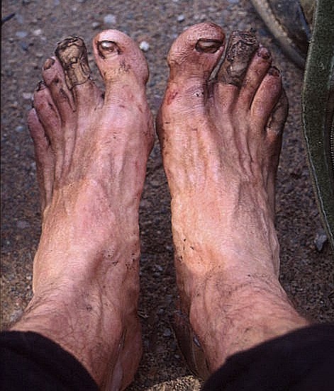
The effects of nine days in wet Telemark boots
Update: Four
Day: 25
Kilometres: 549
Cumulative height gain: 14, 450m (one and a half Everests)
Consecutive days of carrying skis without using them: 12
Consecutive days involving rain, hail, sleet, and/or snow: 16
Dampness index: Webbed skin is beginning to develop between my toes and between my fingers.
Current attitude: It's all worth it! Read on and you'll understand...
The beers, food and hospitality bestowed on me by Brian, Anthony and Jason at Sheepyard Flat was no one-off. Arriving at the Bluff, it transpired, had brought me into the High Country Hospitality Zone, as the subsequent week was to prove. Hitching out of Mansfield after stocking up on food, showers and caffein, I was picked up by an old couple who were heading up to their holiday home near Mt Buller but, on hearing of my sea-to-summit trip, took me all the way to Sheepyard Flat--involving a journey 50km out of their way, and along a rutted dirt road--then left me with their home address in Melbourne if I needed a place to stay when I returned to the city. I spent the afternoon forlornly sitting in exactly the same place as I'd been when Brian invited me back to their fire, hoping instead to head in the other direction but nobody was going past. About an hour before dusk, I walked back to Brian�s empty fishing shack, headed next door to the neighbours Lee and Dick who live there permanently and explained to them that I'd stayed there on the weekend. Would it be all right to doss on the verandah of Brian's place? No problem, they said, and they even brought me over a cup of tea and freshly-baked biscuits that evening just before the heavens opened. The following morning, the dawn chorus (and my daily ritual of convincing myself to leave the warm enclaves of my sleeping bag) was accompanied by Lee's call: "John, I've made some porridge for you!" This was like staying with my granny when I was a kid. Dick came over soon after with a spare pair of socks he thought I might use, to which I tried to explain diplomatically that I had pared my pack down to having everything I needed and nothing more.
I walked back up to the same spot again to resume the hitching vigil, which over the next four hours was broken only the arrival of a Police four-wheel-drive having a look around. The two constables took down my details and tried to convince me that my plan of heading to Mt Hotham amounted to a particularly convoluted form of committing suicide, a proposition I tried in vain to refute. That diversion aside, the hours ground by and I was almost resigned to missing the chance of getting to Bluff Hut to take advantage of the supposed good weather forecast for the following day. That's when a Melbourne butcher who was camped in the flat came over for a chat, heard about my trip and then decided to drive me to Eight Mile Gap on the truly spurious justification that it would "charge the battery" of his Land Cruiser. He wouldn't take my offer of payment for the 90-minute journey there and back. That made two lifts in which I was taken to a place where the people who picked me up had no plans to go to--the HCHZ was working overtime. A couple of hours along the road took me up to the hut, perched on a saddle at about 1500m and just into the snow zone from which further progress would be by skis. The forecast had been for good weather the following day, which I hoped would get me to Vallejo Gantner hut, the launching spot for the Cross Cut Saw. This aptly-named ridge was likely to be the hardest part of the whole sea-to-summit journey and demanded good weather to cross it. Back in 1989, I'd put a food and beer dump in near here in the summer then in August had skied in with a group of friends for a week's Telemarking. We'd had to wait six snowy days before finally getting the chance to get on to the Cross Cut Saw, and that was in conditions which ended in one friend having a massive cornice collapse under his skis four metres back from the edge, while another friend was caught in an avalanche as we skied the gullies off the mid-point of the ridge. The week ended with a epic retreat over the summit of Mt Howitt in a storm and then a long and wet two-day slog back to our cars. On my own, 11 years later, the risks of trying to do the ridge in anything other than good conditions were obvious. The forecast had said the weather was likely to be bad for the following day but I had nine days food and was prepared to wait two or three days in Gantner hut for my chance. Then the latest forecast on my radio that night changed the one day of bad weather into three and no guarantee that that would be the end of it. At that point the previous 10 days had all involved precipitation of some kind so with a heavy heart (read: seriously pissed off) I abandoned the Cross Cut Saw route and the next morning headed off on a longer alternative route along a series of four wheel drive tracks.
Depressing or not, it proved to be a good call, for the following days showed that I'd not only entered the High Country Hospitality Zone but also the High Country Truckloads Of Rain Zone. The supposed fine day had involved a white-out with occasional snow showers and over the next four days the heavens opened. Each night the radio news reports involved flood warnings for all rivers around where I was, prompting a series of route variations to avoid uncrossable rivers and an eventual l-o-n-g road-bashing detour back up to the Great Dividing Range. Towards the end of this, I ran into a farmer and asked if there was a farm hut I could stay at up the valley, to which he directed me to another fishing shack four kilometres away. As I arrived, a group of deer hunters were just leaving, and they plied me with a six-pack of beer on the paper-thin lie that if I didn't take them they were likely to be thrown away! I accepted with gratitude.
The route ahead lay over the Barry Mountains, renown as "the dry Barrys" because in summer water was often unobtainable for 20km at a time. By that point, every day for the past 15 days had involved precipitation of some kind so the prospect of the Dry Barrys sounded like just the ticket. It rained, of course, for the next two days but I was bouyed along by the prospect of reaching the Mt Hotham Road and the epicurean benefits which would flow from my arrival in Bright soon afterwards. By that point I'd been carrying the skis for 12 days without using them so the arrival of snow on the ground 6km from the Hotham road was a heady prospect. The trouble was I was in the marginal snow zone and the four-wheel-drive track I was following zig-zagged along the undulations of the west-facing ridge. On the shaded south-west slopes, it was skis on for thigh-deep snow then on the sunnier north-west ones it was skis off again. On and off, on and off, on and off until I fully realised the true meaning of the epigram that it's dangerous to wish for something because you might just get it.
After a day of recuperation and caffein-fixes in Bright, I hitched back up the road (in the rain, of course) then skied and walked the 10km to Mt Hotham. This was by far the highest I'd been on the trip and the snow cover reflected this. By now it was almost the middle of September but there was more snow around than I'd ever seen in the past, even in the heights of winter. The drifts beside the road at the Mt Loch carpark were up to four metres deep.
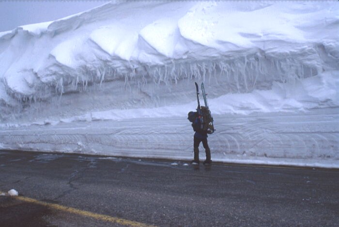
Getting off the road and onto the snow was not easy at Mt Hotham
From there, the route to Falls Creek is marked by snow poles between 2m and 2.5m high but even several of these were completely buried. The skiing was fabulous though and lasted almost all the way down to Cobungra Gap, where Dibbins Hut offered rustic accommodation for the night. After 16 days of precipitation in a row, the next day made up for it all with a wee gem. Clear blue skies and no wind and deep, fabulous, wonderful snow. My mood soared as I climbed up through the snowgums to the High Plains and then along the snow pole line to Falls, arriving sunburnt and raving and realising how depressing the previous hundreds of kilometres of muddy four-wheel-drive tracks had been. A quick hitch back to Bright for a rest day then Graham is due to join me to head towards Bogong, the highest mountain in Victoria.
Update: Five (and final)
Day: 33
Kilometres: 763
Cumulative height gain: 20,690m
Graham arrived bearing his 130cm downhill skis with matching skins, which were standard fare for winter climbing in the French Alps since they were short enough to be carried on the outside of the pack while climbing and aptly stable and turnable for the descent off the mountain when the climb was over. Amidst the long and thin Telemark skis of backcountry touring in Australia, though, they gave every impression that he had gained his planks by mugging a 12-year-old. His choice was probably not surprising given that his first experience on Telemarks was on difficult terrain off the back of Mt McKay at Falls Creek in tricky snow conditions and on board a pair of 1980s skis which turned with all the alacrity and speed of an ocean liner.
No matter. One benefit of the final arrival of good weather was that the snow would freeze every night and so we had to wait until after 10am before it was soft enough to ski on. This phenomenon was one of my favourite aspects of Australian spring skiing since it not only allowed but demanded leisurely starts to the day, which could be squandered without guilt on drinking quality coffee and generally faffing about. As an antidote to the midnight to 4am starts required by alpine climbing, it could not be bettered. Eventually though we had to head out onto the plains, around the dam and up towards Nelse. This is heartland territory to any Victorian cross country skier although it can get a little dull when you�ve done it for the umpteenth time. To add a little interest into the experience, in my final season on the high plains in 1989, a friend and I used to ski out when we arrived at Falls Creek at 10pm on a Friday night so long as the weather was foul enough to be laying down new snow or preventing the existing stuff from freezing. There was no point using head torches in this stuff, which became a monochromatic world in which you could see your own skis, the outline of the other skier and (hopefully) the next snowpole. On really foul nights, one of us would have to stay at the last snowpole while the other would head out into the murk trying to find the next but the reward, apart from adding interest, was the guarantee of a bed in the notoriously busy Edmondson�s hut, which each weekend groaned with the legacy of being the closest hut to Falls Creek.
Following the snowpoles near Mt Jim
With Graham, it was the exact opposite, with clear blue skies and perfect visibility in every direction. It was constantly surprising how much snow there was around, especially for the middle of September, and Nelse�s usually rocky south face was as smooth as the baby�s proverbial. By the time we got there the slope had been in the sun for an hour or so and was in perfect spring conditions, which was too much to resist and so we spent a happy hour or so carving easy turns in snow which flattered our abilities. In another hour or so, we skied into the snowgums outside Ropers Hut, a dwelling that had been built in 1939 by one of the cattlemen who used to graze their stock on the high plains in summer. When we arrived there, it was hidden by about 1.5m of snow, a drift of which continued over the roof and which made getting into the front door more like caving than walking. With the equinox only a few days away, there was plenty of time to gather wood for the fire and water for the dinner before retiring with a cask of wine to tell tall tales and (occasionally) true around the flames.
At an appropriately slothful hour the next morning � due entirely to the need to let the snow melt sufficiently for skiing, you understand - Graham headed back to Falls (and the prospect of a plush dinner party in Melbourne that night) while I headed down Duane spur towards Mt Bogong. The prospect of a steep descent on morning snow through the snowgums was not something I was looking forward to but the benefits of doing this trip in Spring were amply demonstrated by the transformation of the route within 100 vertical metres from 1.5m of snow to nothing. After an 800m descent, I arrived at the appropriately named Big River, which had to be forded to go further. After my rain god experience earlier I was wary of this but the chain that used to be there to assist crossings was still in place, allowing a safe crossing, albeit involving a waist-deep immersion into snowmelt.
A matching 800m ascent took me to near Cleve Cole Hut, a sturdy and luxurious stone auberge that was built in 1937 after the death from hypothermia the previous winter of skiing pioneer Cleve Cole after he and two others were caught in a storm near the summit of Bogong. This hut had been one of my favourite bases for Spring skiing excursions back in the late 1980s. The trouble I'd encountered back then was that a large part of the weekend was spent making the ascent of the mountain, after which enthusiasm for steep and deep XCD runs was markedly deficient. Our solution to this on one trip late in the 1988 season was to head up the mountain at night after driving from Melbourne, follow the snowpoles for a post-2am arrival at the hut, and then enjoy two full days skiing. This went without a hitch - well, except for the inconsequential fact that it started to rain soon after sunrise on Saturday, with the result that we spent the whole day in our sleeping bags. We were, though, feeling just a little smug at our midnight ascent and, as always happens, when a tiny bit of smugness infiltrates my psyche, reality conspired to bring me down a peg or two. Around lunchtime, an elderly gentleman arrived at the hut carrying just a daypack and wearing plastic ski-mountaineering boots. This was none other than Mick Hull, who had been one of the unfortunate Cleve Cole�s two companions on that ill-fated 1936 ski trip and who was wearing two different sized ski boots to account for the loss to frostbite of his toes on one foot from that disaster. What was he doing up here? Celebrating his 79th birthday, of course. That put us in our place, particularly when he produced the key to a locked section of the hut and appeared a few moments later bearing bottles of a familiar amber substance, asking: �Would any of you boys like a beer?�
Back to this trip, the others in the hut included members of the Bogong Ski Club and thus had access to the locked section, from which emerged bulbs for the solar lighting system and all sorts of luxuries that had been carried up during the summer. I dumped most of my pack�s contents then skied up to the 1986m summit, passing in the process the tracks of the 20-odd skiers doing the gullies off the summit massif. By the time we all returned to the hut, everyone was buzzing about the perfect spring conditions and the 500 vertical metre runs out of which it had taken 90 minutes to climb out. The most any of them managed was four runs.
One of the two-metre-plus snow poles
A convivial night had me pondering taking a rest day the next day so I could enjoy the steep and deep gullies in prime condition but the weather had other ideas, with a brief rain shower coming through around dawn making the snow rather less fun than the day before. I opted to head off the High Plains and head towards the indistinguishable peaks of the Main Range that shone like a huge blancmange on the horizon. Skiing down Long Spur was very entertaining � well, entertaining at least for anyone who would have watched me attempt to tackle sudden and unforeseen changes in snow texture between wet porridge and hard-frozen crust. The Inuit are said to have 21 different words for snow but within a few kilometres, I had far more than that. Admittedly very few were of a kind you would be able to use in the company of the local vicar but they were remarkably apposite to the situation.
A few hours of travel took me below the snowline and late in the afternoon I emerged onto the Omeo Highway at the old gold mining settlement of Glen Valley. The plan was to walk a few kilometres up the valley to the turnoff for the road I needed to follow the next day then hitch the 55km to Omeo, where my next cache food/map/guidebook extracts were waiting. Trouble was that in the two or three hours I was on the road the only traffic was Gordon, the owner/builder/proprietor of a mountain retreat at Glen Wills who transported my pack up the hill, and a young couple from near Melbourne who were in a state of anxiety because two friends supposedly walking the Australian Alpine Walking Track had failed to make it out before dark. In what was to become typical fashion, Gordon invited all us in to his house and helped co-ordinate the rescue of the missing pair, who were eventually found by the police having returned to their starting point. I ended up staying the night (and enjoying a sumptuous hot shower, let down only by the need to get back into my scungy thermals again afterwards) before heading on to Benambra along the Knocker Track. The skis seemed a bizarre affliction as I walked through dairy country before finally arriving 33km later at Benambra late in the afternoon. My arrival became an object of amusement to a posse of young girls on their bikes, who helpfully suggested I walk the 25km into Omeo rather than waiting for a ride. After several rounds of having my remaining shreds of dignity ridiculed by these pre-pubescents, an elderly landowner took me into Omeo. The journey was enlivened by recounting his friend�s experience with an English rambler who was sent to do the seriously remote Taylors Crossing to Thredbo section of the walking track, which he had assumed would be something akin to the GR5 in France or the Milford Track in New Zealand. He was found, by luck rather than by good management, a few days later waterless, lost, and having been unable to relocate his pack after he hid it while climbing a tree to ascertain the nearest outpost of civilisation. He was last heard of catching a plane home complaining about what an awful place Australia was.
After collecting everything from the Omeo B&B where I�d sent my cache, the hitching back to Benambra was simplicity itself. I�d thought about trying to get my pack sent along the Limestone Road to save me carrying it but gave up because of the difficulties the plan entailed. Good news then when the farmer who gave me a lift to Benambra announced he owned a farm 16 miles along the Limestone Road and would happily take my pack there. He also offered to take me there as well to which I regretfully declined, saying that although it might be an appealing prospect, once I was at home and rested I�d rue not covering the whole distance myself. Packless walking was just bliss, providing an opportunity to actually look around rather than just as the usual metre-wide circle of tarmac immediately in front of my feet. The kilometres breezed by until I collected my pack and shouldered it up a hill towards the two huts marked on my map about 8km further on. I�m not sure what it is about me and huts but something about my intention to make one a destination conspires to give it a life expectancy roughly equal to that of an east African democracy. In this case, the first hut had collapsed to a few feet high while the other simply didn�t exist. It was at least a fine night and all I needed was something to keep the dew off (without having to get my tent wet) so I made myself comfortable in the remains of the first hut.
Early the next morning, the track veered off the road and into the �Wilderness zone�, although this particular version of wilderness involved a series of four wheel drive tracks and huts, which was somewhat markedly different to the New Zealand interpretation on the word. It was, however, an area restricted to access by foot or mountain bike, with the result that the talismanic roadside trail of VB cans I had been following since the Prom mysteriously dried up. It was probably just a coincidence that the absence of four wheel drives also resulted in an absence of beer cans and an increase in wildlife. The trail headed around a hill then down to Cowombat Flat, which used to be the northern terminus of the walking track back in the days when it was an all-Victorian affair. Cutting across the flat near a herd of brumbies was the mighty Murray River, being not just the boundary between New South Wales and Victoria but also Australia�s longest river. Up here near its headwaters though it could be easily hopped across and had the width of about 20cm, which provided me with an amusement value far in excess of what it deserved and served as yet more proof that I�d been walking on my own too long.
By this time it was about 3.30pm and the flat was an appealing place to set up camp, knowing that I�d have Tin Mines hut for lunch the following day and Cascade Hut (providing it didn�t succumb to Henzell Hut Syndrome) for the following night, then a short walk out to Thredbo on the Friday so that I could summon Mark Virtue to meet me for the ascent of Kosci the following day. That was appealling but for reasons not immediately obvious, I opted to push on to the hut. By this time the Sydney Olympics had just begun, which increased the entertainment value of the radio reports but which obliterated the previously helpful detailed weather forecasts that the ABC broadcast each evening at 9.45pm. Since the opening ceremony, I�d had to attempt to discern alpine weather trends from the three-word forecasts for Melbourne and Sydney, each of which were coastal cities more than 600km away. Perhaps my decision to head on to Tin Mines was based on some subconscious affinity with rain-bearing weather formations (stormclouds and I were, after all, now on first name terms) because it hosed down for much of the night. I listened to this with bemused detachment, entertaining myself with the hut log book and its accounts of schoolkids for whom their walking trips through one of the Australian high country�s most scenic sections was a two-fold misery of missing episodes of Home and Away and undergoing exertion of a kind which they thought only existed on a Playstation. These included a Melbourne private school�s annual �Kosci to the coast� expedition, which hiked to the Snowy River then rafted to the sea, and also the entry of a guy who a few years back had made the first winter traverse of the Australian Alps Walking Track.
By the time I emerged the following day, the skies were clear and the conditions were making it clear that Spring had sprung. Temperatures were relatively balmy, with the result that the annoyances of the Australian bush were beginning to make themselves apparent instead of just being the subjects of complaints in the log books. Blowflies were buzzing and biting ants made me have to think before dumping my pack at each rest spot, meaning that the biting March flies and poisonous snakes could not be far behind. Despite the absence of VB cans to show me the way, I was able to navigate my way along the rolling plateau and over the metre-deep snow of the small range standing between me and Thredbo, arriving in time to savour the fine coffee of the Altitude 1380 caf�. With real coffee, just 10km to go and a fine forecast, everything was finally falling into place. The only thing missing was Mark, but when I phoned he could not face the 500km journey up from Sydney for the sake of doing the final 6km to the summit. A short talk had the resulted in a range of justifications but at the end of the day, it was seemed to be a case that he had mentally moved on from the draining experience he�d been through in June and July and had no desire to revisit it.
The following morning I headed up from the whimsically-dubbed Dead Horse Gap at 9am, a time which another cross country skier at the backpackers had assured me would involve snow which was fair game to ski on. After being rained on one night and then left under the clear blue skies of a massive high pressure system on the next, I found it frozen into what one of my Kiwi climbing partners used to fondly refer to as Alpine Racing Concrete. ARC is a happy find in summer when you want to race on crampons across neve to the bottom of a route but it wasn�t much fun here and I gritted my teeth at the realisation that after carrying my skis for the best part of 500km, I was having to carry them up the lower slopes of Kosciuszko. Two hours later, it was still frozen bastard hard (another good Kiwi phrase) and I skidded, clattered and skittered my way into the Eagles Nest caf� at the top of the Crackenback chairlift. I only had to spend a hour drinking hot chocolate and watching the Olympics until the sun did its work on the snow.
The mighty alpine peak of Quasimodo, er, Kosciuszko
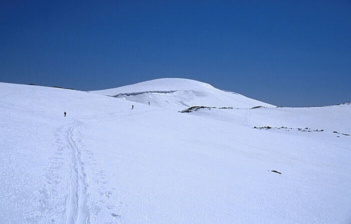
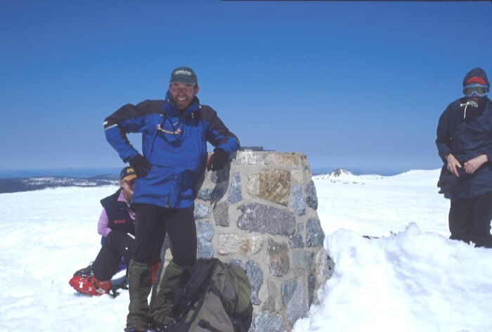
By the time Kieran Perkins had set a sub-15 minute qualifying time in the 1500m swimming heats, the snow was fair game and I set off on the final lap, following a line of snowshoe tracks across the rolling neve. In a short time, the Great Alpine Peak of Kosciuszko appeared over the horizon, looking for all the world as if the Matterhorn had been made out of Ice Cream and then been left beside the fire for several hours too long. It was so rounded and non-descript that Strzelecki had climbed the neighbouring peak, Townsend, as well because neither one looked higher than the other. After threading a way between two cornice lines, the slope gradually eased off (not that it had ever been particularly steep) until the summit trig point finally appeared and the full panorama of the Main Range was revealed.
I touched the trig with an unexpectedly wide grin on my face, followed immediately after by one of a group of Thredbo ski instructors who had opted to climb Australia�s highest peak as their end-of-season day off treat. This group had traversed the Rams Heads lower down to come up from Lake Cootapatamba rather than taking the direct route I�d followed. �We went the long way,� one woman explained, when I asked about their ascent route. �Yeh,� I replied, �Me too.�
Back to the home page
Go to Mont Blanc
Go to Aconcagua
Go to Mount Cook