|


The geography of Chile is extremely diverse as the country extends from a latitude of 17° South to Cape Horn at 56° (if Chilean claims on Antarctica are included Chile would extend to the South pole) and from the ocean on the west to Andes on the east. Chile is situated in southern ocean , Ameirica bordering the South Pacific Ocean and a small part of the South Atlantic Ocean, between Argentina and Peru. Chile's territorial shape is among the world's most unusual. From north to south, Chile extends 4,270 kilometers, and yet it only averages 177 kilometers east to west. On a map, it looks like a long ribbon reaching from the middle of South America's west coast straight down to the southern tip of the continent, where it curves slightly eastward Cape Horn, the southernmost point in the Americas, where the Pacific and Atlantic oceans turbulently meet, is Chilean territory. Chile's northern neighbors are Peru and Bolivia, and its border with Argentina to the east, at 5,150 kilometers, is the world's third longest. Area: The Andes The Andes (Cordillera) run along the entire lenght of the eastern part of the country. The watershed between the Pacific and Atlantic oceans, which follows the central and often highest ridges of the Andes, was adopted (by agreement with Argentina) as Chile's eastern boundary. In the north, approximately to latitude 27 grades, the Andes consists of two or more almost parallel ranges. The Chilean Andes are highest and most rugged and precipitous in the northern and central parts of the country, with peaks above 6,000 meters (20,000 feet). South America's highest peak, Aconcagua (22,834 feet), rises just east of Chile's border. Mountain passes in this part of the Andes are few and difficult, rising above 10,000 feet. South of Santiago the Andes become gradually lower, with peaks of aproximately 12,00 feet. Passes are much lower and easier to negotiate. In the extreme south, the Andes are fragmented by deep, latitudinal valleys (of glacial origin) deep ocean inlets and channels. The mountains extend trough the island of Tierra del Fuego to the southern end of the continent.
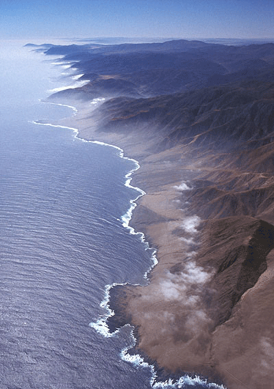
The Coastal Range The second structural region is the coastal range (Cordillera de la Costa), which follows the coastline closely throught northern and central Chile, from Arica to Puerto Montt. It rises abruptely from the shoreline in high cliffs that for hundred of miles form an unbroken wall, creating a coastline devoid of natural harbors and a formidable obstacle to acess inland. Large parts of the coastal range are actually an eroded plateau descending west to the sea by cliff-bound terraces. The coastal range rises to an altitude of approximately 8,800 feet. The southward extension of the coastal range beyond Puerto Montt forms a chain of approximately 3,000 hilly islands, extending along a fjord-lined coast to Cape Horn at the southern extremity of the South American continent. The largest of these islands is Chiloe, just south of Puerto Montt. This chain of islands is interrumpted by Taitao Peninsula, which is southern relic of the triple-longitudinal-belt structure that predominates farther north.
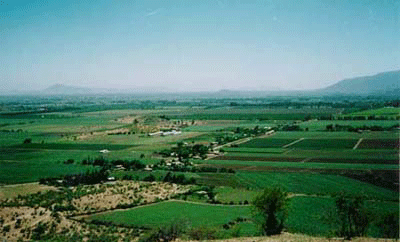
The Central Valley The third structural region, and the most important one, insofar as human settlement is concerned, is the depression between the Andes and the coastal range known as the Central Valley. It is a long and narrow basin of varying width, reaching approximately 80 kilometers (50 miles) at its widest section. The Central Valley is not continuous; it is interrupted by spurs from the Andes and is divided by a wide mountainous introsion into two main basins, each of which includes a number of smaller basins. The northern basin, extending from Arica to Copiapo, is the Atacama desert, one of the driest areas on the earth. The second major basin is that of central Chile. It extends from , Santiago southward to Puerto Montt and is Chile's main agricultural area and its most densily inhabited region. It is climatically the most attractive part of the country.
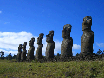
The Islands Territories Chile owns several groups of small and mostly inhabited volcanic islands opposite its shores in the eastern Pacific: The Juan Fernandez Island, Easter Island, Sala y Gomez, San Felix and San Ambrosio, and Diego Ramirez Islands. Chile claims a section of Antarctica between longitudes 53 and 90 degrees west and the neighboring islands.
|