  Polar regionIntroduction Frilandic scientists conduct research on both the North and South Pole, especially regarding climate and the environment. These projects are led by the Department of Polar Research ("Skul fur Hwerbfandung" or SH) of the Royal Meteorological Society ("Kununglik Wedarkunstig Ganautskap" or KWG), which frequently collaborates with other countries. Bordering the Arctic lies the Frilandic overseas territory of Wulfmark and in the Antarctic are the Frilandic dependency of Harinsland and the Algunþsland claim, more about these on this page. 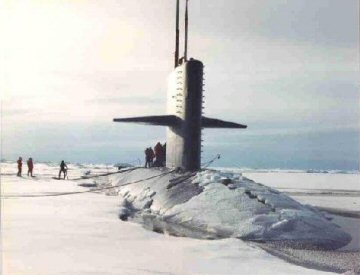 The FS Stabsburg evacuating scientists from Isgard North Pole The only Frilandic station on the North Pole is Þurisjek ("Ice Sheet of the Giants"), which is located at the Independence Fjord in northern Greenland. In its Arctic research Friland closely collaborates with other countries, which is why Þurisjek also receives many foreign scientists. In addition to climate research, archeological research of Paleo-Eskimo cultures is also being conducted since 2013. In 2008 Þurisjek replaced Isgard, a research base that was located on a floe near the North Pole. Because of global warming, the floe was getting smaller and more unstable, eventually getting in danger of breaking apart. The scientists and their equipment were then quickly evacuated to the new Þurisjek station by the nuclear submarine FS Stabsburg. Some weeks later a reconnaissance aircraft confirmed that Isgard had completely disappeared into the Arctic Ocean. Despite its proximity to the North Pole, Frilandic interest in the South Pole was often greater. The probable cause for this is the failure of four consecutive Arctic expeditions in the 19th century, in which so much money and human lives were lost, that it took until 1995 before Friland dared to organize another Arctic expedition. The adventures of explorer Harin Segmersduhter in the Antarctic will have also contributed to a greater interest in that region. South Pole The Frilandic presence in the Antarctic consists of two territories: the sub-Antarctic Harinsland archipelago, an internationally recognized Frilandic dependency, and the Algunþsland claim, a part of the Antarctic continent that is claimed by Friland but not recognized by every country. Both areas form the Frilandic Antarctic Territory (Frilandisk Sunþhwerbland), belonging to the Southern Domain, a Frilandic overseas territory. Harinsland and Algunþsland are governed from Storgard, the capital of the Tern Islands and the Southern Domain. They have no permanent population but they do have polar stations, where scientific research is conducted. It's one of the coldest and most remote places on earth and can only be visited by ship or airplane. The time zone is UTC-6 (CST - Central Standard Time). The territory flies the flag of the Southern Domain, displaying a star that represents the Southern Cross. 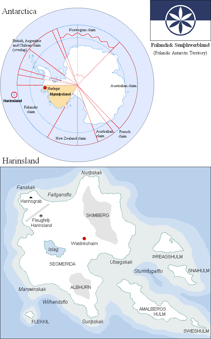 Antarctica Algunþsland, the Frilandic claim in Antarctica, largely coincides with Marie Byrd Land. The territory has an area of 1.610.000 km² and is located between 158°W and 103°24'W. Peter I Island, which belongs to Norway, is not covered by this claim. The Antarctic Treaty, which is also signed by Friland, freezes all claims in Antarctica. Algunþsland is therefore not internationally recognized. Friland claims Algunþsland since 1925, when an expedition led by Audgisal Haimrikssun visited the area and named it after the former queen Algunþ. It is one of the coldest and most remote regions on Earth, making it very difficult to visit. Audgisal Haimrikssun only briefly visited Algunþsland and lost half of his team there. The current polar station of Haslegar, which is only sporadically used by scientists and sometimes remains unoccupied for years, is therefore the only Frilandic presence in the area. Locations on Antarctica: Polar station Haslegar ("Camp Icicle") The polar station on Algunþsland, the Frilandic claim in Antarctica. Harinsland First expedition Harinsland is a sub-Antarctic island group that was discovered on July 17, 1815 by the then 24-year-old explorer Harin Segmersduhter from Wisundfelþ. She landed with her team in Penguin Bay (Faitgansflo) and planted the Frilandic flag on Cape Banner (Fanskak), thereby formally claiming the islands for Friland. The team then built a cabin and spent a few days there, which were used to map the archipelago. Second expedition In a second expedition in 1823, the now 32-year-old Harin returned to the archipelago. In that time, knowledge about the Antarctic was limited to a few islands, coastline observations and rumours about a large, frozen continent. Harin explored the ocean around Harinsland and thereby mapped unknown parts of the Antarctic coast. During one of those explorations her ship "Raunjar" (Explorer) got stuck in the pack ice. Attempts to free the ship failed and after three weeks the Raunjar was so damaged by the moving ice shelves that it sank. Harin and her team were several hundred kilometers from Harinsland and therefore decided to cross the drift ice with tiny rescue boats placed on sledges. By sledging and sailing over ice and water they managed to reach the islands after three months. Eight of the twenty crew members were killed and the survivors suffered from severe frostbite. The end On Harinsland there were a food supply and a large boat, that they could use to reach the itinerary of whalers, offering them a chance of rescue. However, Harin and most other members of the team were too weak to be able to make this journey and they were forced to stay behind. Four crew members left with the boat to get help and spent weeks at sea, until they were rescued by a Norwegian whaler. A rescue team was sent to Harinsland, but the remaining eight crew members were found dead. In Harin's frozen fingers they found a note containing the following poem:
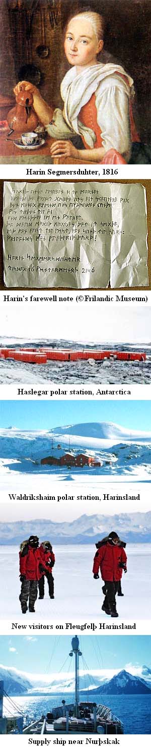 The bodies were transferred to Friland, except that of Harin, whose last wish was to be buried in the soil she had discovered. She was therefore buried on Cape Banner (Fanskak), where she had planted the flag on July 17, 1815. It's a tradition that every visitor to Harinsland visits her grave and removes the snow from her tombstone, which is believed to bring luck. Also, the last three lines of her farewell poem are often used in obituaries.
Research After the fateful expedition inhospitable Harinsland was left alone for more than a century. In 1925 the archipelago was internationally recognized as a Frilandic dependency and in 1930 it was visited by airplane and further mapped. In 1960 people landed on Harinsland again, and the polar station of Hermlaushaim was built. Since then Harinsland has been repeatedly visited for scientific purposes. In 2006 a new polar station was built, which is named after king Waldrik. Harinsland has no permanent population: the islands are mostly abandoned but from time to time polar station Waldrikshaim houses about 10 to 20 people, mostly scientists. Outside of that, surveillance of the islands consists of only a handful of strategically placed webcams. Locations on Harinsland: Polar station Waldrikshaim The polar station on Harinsland, the Frilandic archipelago near Antarctica. Named after king Waldrik. Fleugfelþ Harinsland ("Harinsland Airfield") Besides supply ships the only way to enter or leave Harinsland. The "airfield" however, is nothing more than a makeshift airstrip with a repository for kerosene, gasoline, spare parts, a rescue boat, food and some snowmobiles. Harinsgrab ("Harin's grave") The grave of explorer Harin Segmersduhter (1791-1823). Segmerida The largest island of Harinsland, which Harin named after her parents Segmer and Ida. Flekkil ("Spotty") Islet that Harin named after her dog Flekkil. In her own words because her brothers had laughed at her when they heard of her upcoming expedition, and that the dog was therefore more deserving of it. Þreagshulm ("Triangle Island") (island) Snaihulm ("Snow Island") (island) Amalbergshulm ("Amalberg's Island") The second largest island, named after the then queen Amalberg. Sweshulm ("Island of Loneliness") (island) Skimberg ("Clear Mountain") (mountain) Albhurn ("White Horn") (mountain) Fanskak ("Cape Banner") Spit of land on which Harin planted the Frilandic flag in 1815. Nurþskak ("North Cape") (cape) Utsegskak ("Cape View") (cape) Sunþskak ("South Cape") (cape) Marswinskak ("Cape Dolphin") (cape) Faitgansflo ("Penguin Bay") (inlet) Wilhandsflo ("Wilhand's Bay") Inlet, named after king Wilhand in 1930. Sturmfugalflo ("Petrel Bay") (inlet) Islag ("Ice Lake") (lake)  |