To next page
Al Qalqachandi (1418) Soubh al Acha fi Sina at al Incha
(The blind become seeing on the subject of writing) Egypt
-----------------------------------------------------------------
Taken from: Youssouf Kamal IVfasc4
The sea is here on the south of the earth, it stretches further west and reaches the deserted countries behind the land of the Zandj. Then continues in north east direction to join the sea of Sin and al Hind....
Further on she (the sea) passes the city of Maqdichou then going further reaches the gulf of Barbara which comes out of the southern site of the sea of al Hind as we will say later if it pleases to god. After passing the beginning of the gulf the sea reaches the shores of the country of the Zandj till the end of this place, after that comes the coast of al Waq-waq where the sea reaches unknown coasts....
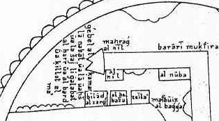
Know that the origin of this river (Nile) is in the beginning of the uninhabited land which is found on the south of the equator mentioned here. Because of that it is difficult to get a precise knowledge of it. The scientists say it comes out of the mountains of the moon Djabal al Qamar which is the most used pronunciation or al Qoumr which is the pronunciation given in Taqwim al Buldan.......
Ptolemy says: the Nile descends from the said mountain in 10 rivers each separated 1 deg on the indicated longitude. The first most western one is at 48 deg long the 2nd at 49deg etc... till t he 10th at 59deg longitude. Each water forms a river. The 10 rivers unite and run into 2 swampy lakes so that each lake gets 5 of them. From each of them leave four rivers who branch into 6 rivers going north where they end up in a circular lake close to the equator. This lake is called lake Koura; After leaving this the Nile cuts in three branches; One of them goes east to Maqdachou in the land of Habachy-muslims on the shore of the Hind sea opposite the land of Yaman (The other branches are the Nile of Ghana and the one of Misr)...
(The land) is limited on the eastern site by the Sea of Qoulzoum opposite Yaman and by the unknown places situated to the east of the land of the Zandj... South and west (of Donqoula) there are the territories where are the Zandj and the Nuba.... then the town of Maqdichou.... Between the first clime and the equator... At 72 deg longitude 2 deg latitude.....it is a big town between the Zandj and the Habasha....on t he shores of the sea of Hind. There is here a big river that resembles the Nile of Misr meaning that it floods in summer; it is said it has the same origin as the Nile of Misr from the lake Koura and it ends up in the sea of Hind not far from Maqdichou....there are behind those lands other ones extremely extended about which we have nearly no knowledge. We name the land of the Zandj a country situated between in the east the gulf of Barbari..... the capital is Soufala of the Zandj situated south of the equator.... At 50 deg longitude and 2 deg latitude south....