

This is an uncommon route in the Singalila range. Phalut, the natures own place and famous Mt.Kanchenzongha viewing point in India at distance of 23 km’s from Sandakfu with only one break point at Sabargram, A valley with only one yak-shed. Only tired and gimcrack trekkers don’t visit Phalut, and goes down through the Gurdum and Srikhola. The downward journey from Phalut to Rimbik is through Gorkey-Rammam-Srikhola. Trek to Singalila Pass also starts from Phalut and ends at Versy (Sikkim). Here I’m giving the details of the uncommon route that gives some breathtaking views of Eastern Himalayan range.
![]()
SANDAKFU-PHALUT-GORKEY-DRY LAKE-DENTAM
![]()
![]()

PHALUT-SINGALILA PASS-VERSEY [ESH-03]
YUKSOM-DZONGRI [ESHS-01A]
RABANGLA-MAINAM PEAK [ESHS-04A]
NEW ALIPURDUAR-RUPONG VALLEY [ESHS-05A]
SAMSING-ROCKY ISLAND-JOREPUKURI [ESLA-06A]
LAVA-LELEGAON [EHLA-01A]
YUKSOM-DZONGRI-HMI BASE CAMP [ESHS-02A]
YUKSOM-DZONGRI-SAMITI LAKE-GOCHALA [ESHS-03A]
YUKSOM-DZONRI-KASTURI MRIGA-TASHIDING [ESHS-04A]
LACHEN-GREEN LAKE [CBHA-1]
KALINGPONG-LASA (TIBET) (THE SILK ROUTE) [CBHA-2]
PHALUT-BHUTPOKHRI-BAJREDUNGA-CAHURIKHIANG(HMI BASE CAMP) [INLT-1]
![]()
With a little experience in Trekking, It’s a Dawn-to-Dusk journey from Gorkey to Dentam The route is through the dense forests of the Eastern Range, An experience guide is the minimum requirement of this trek. There are 7 times when river Rimbi Khola crossed our way. Fix a rope and cross it. Dry lake, its natures own golf course with Mt.Kanchenzongha as backdrop. The wilderness beauty can not be described in words, only a successful visit can give the satisfaction. Dentam is a complete downward way from Dry Lake and it’s the most difficult part of the route. Famous Hill station Pelling (Sikkim) is just 20 Km away from Dentam.
![]()
An early start from Phalut will take you to Gorkey by the afternoon. It’s a 13 Km trek(mostly downward) through the green pine forests. Before Gorkey you’ll get the marvelous view of Samanden, "The Lost Valley". River Rimbi-khola is passing through Gorkey. .
![]()
OTHER ROUTES IN EASTERN ZONE :
Copyright
© November 2003 DARK SHADOW FALLING Website is developed By Mr.Arunava Chowdhury
mail : [email protected]
Best viewed with Netscape 4.5 or IE 4.0 & above, in
800 x 600 resolution
![]()
ManeyBhanjan-Meghma - First 2.5 kms. Up then Almost Plane. Meghma-Singalila National Park Gate - There are two ways to moveon. (1) Via Tonglu, a long and tough route but beautiful place with the preview of Mt. Kanchenzongha. (2) through Tumling, an easy way. Singalila-Gairibas- Again two choices - (1) Through the dense forest Singalila National Park. (2) Through Joubari(Nepal). Both are comfortable upto Kaikata. Again two ways from Kaikata. Almost same route. Kalpokhri-Sandakfu- From Kalpokhri to Bikeybhanjan a 7 kms easy walk. Last 3 Kms to Sandakfu from Bikeybhanjan is the hardest part of this trek.
SANDAKFU
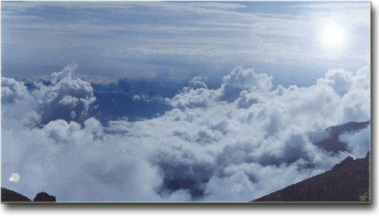
SANDAKFU, famously known as the “country of wild breeze” located in the West Bengal, is the highest peak of the state at an altitude of 12000 ft. from the sea level. The only place in this globe that gives an outstanding landscape with worlds First [Mt.Everest (8848 mt)] and Third [Kanchenjunga (8586 m)] highest peak. The Base camp Maneybhanjan is a small town at a distance of 40 kms from the “Queen of Hills”, Darjeeling. Sandakfu is normal low altitude trekking of 32 kilometers. Recently Jeep services can take you to the top but only trekking can give you the satisfaction of viewing the beautiful Eastern Himalaya. .
Har-Ki-Doon - Borasu Pass - Chitkul
![]()
![]()
![]()
![]()
4![]()
4![]()
4![]()
4
4![]()
![]()
![]()
![]()
![]()
![]()
![]()
![]()
![]()
![]()
A comfortable route for the experienced climbers. There are uncountable routes starting from
Sankari including Black Peak, Dahudhar Kandi, Mt.Bandarpunj, Mt. Swargarihini.
Here I'm giving the details of the great Borasu Pass. A famou trek to reach the interior of Himachal Pradesh, Chitkul from Garhwal. The route is parallel with the INDO-TIBET Border. So, a special permit is required to trek in this area. The permit can be available by applying to National Institute Of
Mountaineering (NIM). Here the details are.. - The journey starts from the
Dehradun (Uttar Pradesh). By bus or car to reach sankri (Via Purola).
The Trek starts from Taluka 6 km from Sankari. Book guide and porters from Sankri(Contact GUIDE and PORTTERS ASSOCIATION office).
Day 1 : Taluka - Gangar - Puwani Garat - Seema(16 km).
Day 2 : Seema - Har-Ki-Doon (13 km).
Day 3 : Har-Ki-Doon - Ratadu - Soune Bhara.
Day 4 : Soune Bhera - Lamjunga (Pass base Camp).
Day 5 : Borasu Pass - Jupkea.
Day 6 : Jupkea - Bunga.
Day 7 : Bunga - Jayari.
Day 8 : Jayari - Chitkul.
![]()