|
Chakana.info |
Samaipata-
|
||
|
La
Chakana |
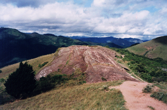
El Fuerte The
main tourist attraction around Samaipata is the archaeological site
of El Fuerte,
9 km east of town. The entrance fee of the ruins is for foreigners 32 Bs, Bolivians 16 Bs and students 5 Bs. This includes an entry fee for the local museum in Samaipata where there is a model of the rock on exhibit. History
They gave it the name of "Samaipata", which is Quechua (language of the Inca’s) and stands for “Rest in the heights”. Around 1540 the Spanish arrived and encountered an Inca fortress. They conquered the Incas and renamed the site "El Fuerte" or "The Fortress". They deserted the site around 1629 when they founded the settlement known today as Samaipata. After the departure of the Spanish the whole complex became densely overgrown with vegetation. Some European adventurers explored the place in the following centuries. Despite this, not until 1974, was El Fuerte recognized as a site of archeological importance. At that point began the slow process of cleaning the carved rock, excavating and constructing a walking circuit. Although much work has been done, the site, which may be as large as Machu Picchu in Peru, is largely covered by dense vegetation. Last year the UNESCO declared El Fuerte as a World Heritage Site. This increases the possibility that more funds will become available for further excavations and better maintenance of this unique, pre- Inca archeological site. Route description
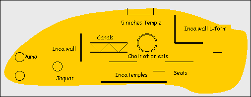
Sculptured Rock From
the entrance
of the ruins you have to follow the path leading up to the West
Side of the rock. To appreciate the size and features of this rock ,
recently a wooden platform and a 60 meter gangway has been
constructed, affording an excellent view.
Map of the sculptured Rock
The
rock
consists
of fragile red sandstone, which enabled the various cultures to
sculpt the entire rock. The most western part has some zoomorphic
designs and includes 2 pumas (symbol of fierceness and
agility), a jaguar (vital force) and a snake (fertility and
eternity). The snake unites the beginning and end of life in
relation to eternity. These animals still live up in the vicinity.
Now
after enjoying the view start walking towards the rock and remain on
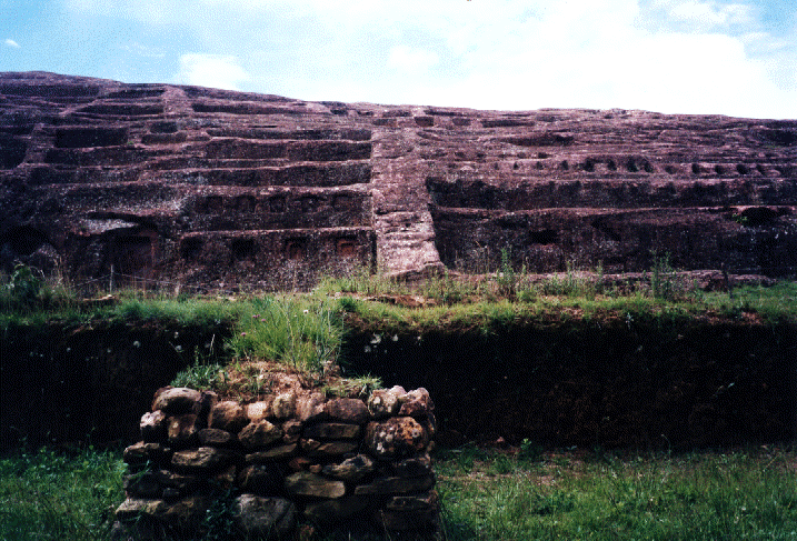
the right side. Continuing on the track next to the rock, there will be 4 more Inca temples. The second was built on a lower terrace. Only the niches remain. Soon
you will reach the Plaza de las Tres Culturas. Archaeologists have found the traces
of 3 different cultures. First there are the foundations of an Inca
house. Then there is the Spanish
colonial house, built
in the form of a W (Andalusia Architecture). Inside there was a
patio. On this part of the rock there could have been an enormous amphitheater. This part of the rock it is full with seats and niches in rows. Beneath the rock, partly under vegetation, the main plaza could have been used for performances. People on the rock could hear the sounds coming up from the plaza. The most eastern part of the rock is sculpted with canals, ponds and geometric designs. Some researchers suggest an enormous hydraulic waterworks system or a place designed for washing gold. Now you are at the northern side of the rock. Here is an L-shaped Inca Wall. There has never been a roof, suggesting that this wall was merely a sign of power of the Inca Empire. From a distance the wall seems more impressive. The niches of the walls have been destroyed by Spanish priests in an effort to extinguish local beliefs. Finally you will arrive at the 5 Hornocinos temple. As this is a very windy place, it's hard to imagine why they built here a temple. It could have served as a meditation temple, as from here you can see a strangely formed mountain. The
people considered this oddly shaped, high mountains as sacred, a
place where their gods were living. Residential/
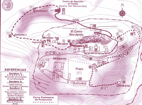
administrative zone
Map of El Fuerte
At the Spanish house you turn left following the descending road leading into the Residential/Administrative zone. The part which you cross now has been the Agricultural Sector that consisted of 9 terraces. A part of one of the terrace walls has been excavated and is visible. This terrace was as long as 250 meter and was used for cultivating potatoes, corn etc. A very sophisticated irrigation system was part of it. At the lower terraces started the Residential Sector. First there is a complex of 3 Inca houses surrounded by a wall. There is only one Point of Entrance suggesting this was a Control Post. Only the foundations of the houses are visible. The walls where made of Adobe (a mixture of earth, clay and grass) which is still in use today (most Bolivian houses are made from Adobe) It keeps the house warm in winter and cool in summer. Archeologists have found here ashes from building materials used for other houses suggesting that the Incas where expelled by tribes from the lowlands (Chiriguanas) and that they later returned to El Fuerte. Passing through the small entrance you will reach the foundations of 2 more Inca houses each with 2 entrances. Up to today, one entrance was only used for the removal of a dead person. Probably more families lived here. Nearby, a lot of provincial Inca ceramics were found. A custom (even today) was to offer ceramics to the gods when one left his house indefinitely. Returning to the 3 Inca houses and continuing on, at the right side there is an enormous open space, the former Plaza. Continuing,
there is to the left the turn off for "La Chincana" or
"Maze", a perfectly round shaped hole with a depth of 12
meter (but in 1940, 36 meter). There are all kind of speculations.
It could have been a water storage room, an entrance to a tunnel
system in order to escape the enemy, or a place to hide. Bordering
the Plaza was an enormous building called Kallaňka.
This
was probably the administrative center of the Incas. Its big
dimensions (68 m by 16
meter) suggest that “Samaipata”
(this was the name the Inca’s give to El Fuerte or “Heights
to rest ”), was an important Provincial Capital of the Inca
Empire, (the most Eastern Province). There is one more Kallaňka
in Bolivia, near Cochabamba, more intact. Still the function of this
building is not really known. It could have been a place for
festivities, markets etc. The entrances are enormous (3.5. Meter)
suggesting that the Inca himself was carried inside on his throne.
Big pillars suggest that the building could be as high as 12 meter
or even consisted of 2 floors. Suggesting that this was the home of the intelligent and beautiful women, chosen by the Inca himself. Their main activity was weaving textiles. There was a heavy Competition who could make the most beautiful ones. Textiles were used for offerings to the gods or for trading. Bear to the left and you will reach the oldest part of El Fuerte. Here are 8 Inca houses. This part has never been destroyed and rebuilt by other tribes, what has happened to the largest part of the complex. From here there is a nice view over Samaipata. Now follow the sign, passing through the agricultural area, arriving at the east side of the Rock and descending to the exit.
|

 the
foothills of the Andes (the Yungas) where the Amazon
Basin and El Chaco
(the dry flatlands of eastern Bolivia) meet. As a consequence many
tribes crossed these valleys and archeological excavations revealed
that the first men who inhibited this site belonged to an Amazonian
tribe, the Mojacoyas, around 800 AD. Probably tribes from El
Chaco lived here as well but it is certain that the Incas
inhabited this place from the late 15th century until 1530.
the
foothills of the Andes (the Yungas) where the Amazon
Basin and El Chaco
(the dry flatlands of eastern Bolivia) meet. As a consequence many
tribes crossed these valleys and archeological excavations revealed
that the first men who inhibited this site belonged to an Amazonian
tribe, the Mojacoyas, around 800 AD. Probably tribes from El
Chaco lived here as well but it is certain that the Incas
inhabited this place from the late 15th century until 1530.