delta is the fourth letter of the alphabet
I have no plans to write up the worlds of Gamma or Epsilon.
As far as I'm concerned, they're uninhabited.
If you want to make them un-uninhabited
(for example by adding oversexed and underdressed women on Gamma),
that's fine, but you're on your own.
Delta has one moon, which is fairly normal as moons go.
Wizards from Atlantis have been there, and found nothing of interest.
Map
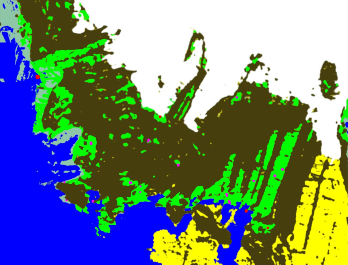
The red dots are cities which appear in the plot:
Thoqmaxar
N.B. Agvhazar
and Havdazar
do not appear on the map. Agvhazar is south-east of Thoqmaxar,
and the distance between the two is about the same as the distance
from Atlantis to Xenby.
Havdazar is even further east.
The purple dots are independent
Ruritanian cities which do not, as yet, appear
in any plot. Vaatjan has a brief listing, and
others may follow in due course. Make up your own city if your players end up
in any of them.
Green areas are cultivated land.
They are usually civilised and have towns and villages at reasonable intervals.
The pale bluish areas are marshland.
Near Atlantis and other cities, these too are cultivated - they are paddy fields.
Elsewhere, they count as wilderness.
The dark brown areas are wilderness.
They are mostly mountainous.
Wherever it looks as if there ought to be
roads through the wilderness joining two cities,
those roads exist.
They will not be straight - they have to wind their way through mountain passes.
Such roads are kept reasonably monster-free.
Away from the roads, anything goes.
The yellow areas in the south-east are desert.
Desert is like wilderness but hotter.
There is little, if any, standing water.
The white areas in the north are tundra.
Tundra is like wilderness but colder, usually below freezing-point.
There is no standing water, but plenty of ice.
The royal blue areas are sea or saltwater lakes.
Ignore the other colours for the time being.
They are just there to make the map less tidy.
Rivers are too small to show up on a map of this scale.
You can work out where they ought to be from the cultivated land,
since cultivated land requires fresh water.
Freshwater lakes and islands are also too small to show up on a map of this scale.
Add them wherever you think they fit in best.
Worlds are spherical, but maps are flat, so
the map is not exactly to scale, and north is not exactly at the top.
The rift valleys in the eastern half of the map run more or less north-to-south.
Many Demons River flows south-west from the tundra down through Atlantis,
and the cultivated area it waters is visible on the map.