This map was made before the developer had come up with a plan.
See the first detailed plan (November 2005)
and the current plan (January 2007.)
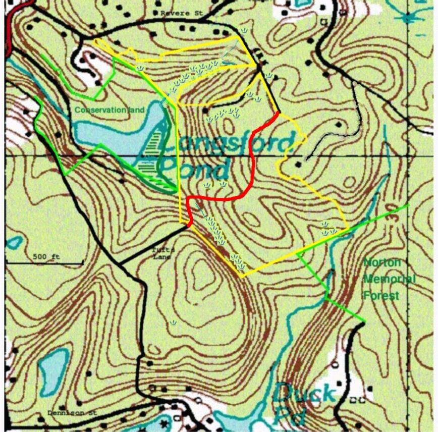
Location.
The red line in the top left is Washington Street (Rte 127.)
Revere Street is along the top.
The line curving down (South) in the middle from Revere St
is Hutchins Court. The
thin dark line branching to the west from Hutchins Court
is the Tufts driveway.
Bennett Street runs from the upper left through the woods to Dennison
Street at the bottom.
The water in the lower left is Goose Cove, with Dennison Street along it.
The yellow outline is the parcel, just over 30 acres, intended for development.
It can be accessed from the end of Hutchins Court on the northeast and from
Tufts Lane on the southwest. Except for the north, northeast, and southwest
sides, it is surrounded by natural areas (woodlands and pond.)
It is heavily wooded with small wetland areas in many places. There is one
house (shown.)
The bright red line is the road proposed from the end of Hutchins Court
to the end of Tufts Lane. The curves are enforced by the wetlands and
the terrain (there is a 75-foot drop from Tufts Lane to the valley below.)
The three 10-unit clusters are planned along the northern part of this road.
The modified plan, conceived after protests from all sides, does away with
the access from Tufts Lane.
Viewing.
The only public access is from the end of Tufts Lane. From there, you can
see the valley which he has to cross ; the road will slope down on the left
to swing around the wetlands. The clusters will be on the same level as the
end of Tufts Lane, on the opposite side of the valley.
The footpath leading down to the right is a public right-of-way, properly
called Saville Row, after Jesse Saville, an 18th-century inhabitant, but
often called Tufts Lane on maps. It follows the border of the development
property for 500 feet, and then leads all the way to Dennison Street.
The valley is described by Joe Garland as "the most gothic valley on Cape Ann."
The full map is 300K and may take some time to load.
![]()