 |
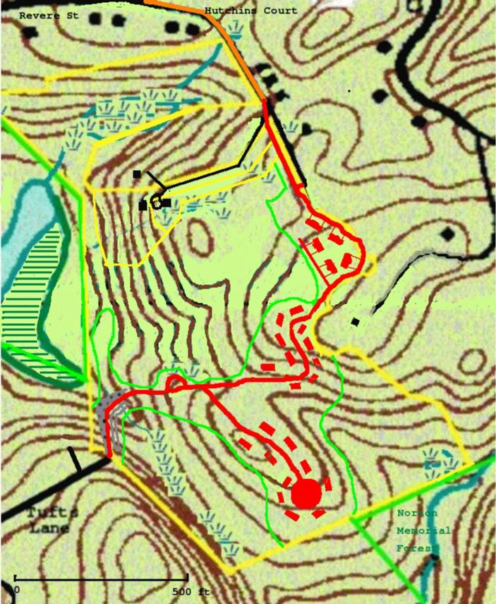
There will be major engineering done. Mountains will be moved and valleys filled. The contours on the accompanying map are from the original USGS map and are pretty inaccurate anyway, but will be meaningless once Carrigan is finished.
Access will be from Hutchins Court and from the end of Tufts Lane, as he had planned.
Hutchins Court will be improved (causing some problems for wetland buffer zones, trees, and maybe someone's front yard) from Revere St until the Tufts driveway, which is where Hutchins Court meets a steep hill. There, a new road will veer right into the Tufts property, bypass the hill, and rejoin Hutchins Court about at the place where it now ends. The houses now on the final stretch of Hutchins Court, from No.14 on, will not be impacted.
Between the end of Tufts Lane and the proposed housing, a distance of about 400 feet horizontal, is a valley with a protected wetland, nearly 100 feet lower. To get a road down and up again would exceed the limitations of slope. So he proposes to build a dam, or causeway, which swings around the wetland. It would be an embankment over 50 feet high, 80 feet across at the bottom, with a riprap slope on the side of the pond, and a concrete wall, over 30 feet high, on the upslope or wetland side. A conservative calculation puts it at 10,000 tons of fill, or several thousand truckloads. Such engineering does not exist in Gloucester except around Route 128. We wonder if he is applying for federal assistance.
Of course, he expects to get most of his fill from demolishing the hilltops. However, this is all granite, and 10,000 tons of granite is a lot of blasting, even if it doesn't have to be moved very far.
The amount of the parcel to be given into conservation is now 66%, down from the promised 70%.
Greenbelt has proposed a plan that would do without the Tufts Lane access and save the valley (which is ecologically important, mainly because of the access to Langsford Pond), but he has had no interest in this proposal.
Detailed maps are available from the Planning Department in the City Hall
annex on Pond Road.
On the map:
Orange - Hutchins Court, improved.
Red - new roads and houses.
Dappled gray (lower left) - riprap embankment.
The green lines indicate the land given into conservation (62%.) This
includes all of the north section of the parcel, which is unchanged.
The first cluster, at the end of Hutchins Court, has five two-family homes.
The other two clusters have ten single-family homes each.