This has got great maps. For the map maker in you, this is it.
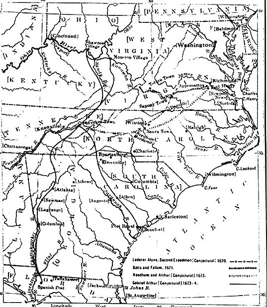
What the colonies, and the explorations by multi-faced
people, had created from 1670-1673, is shown in this map (pg 11) copied
from Clarence Walworth Alvord and Lee Bidgood, The First Explorations
of the Trans-Allegheny Region by the Virginians (Cleveland, 1912) and
I've included it because it helps to know where the states might have been
before they were.
Pretty clearly, the rivers ruled, before the gentry.
We also got Forts and Stations. Haven't figured why they called them stations, but they did. The map that comes in the back of this book, is nice to lay out on the dinning room table and sort through for all the little runs and springs and licks that these hardy people lived on and around.
The first station was Harrods, and our family history
would like to say we helped. That is, Katie's Rhoads'.
I imagine everyone that was around at the time was helping one another,
otherwise thump, down on the ground with the natives. Hard to imagine
either natives, or white men, which one was afraid the most. We know
who won, but that was a number's game, and a virus game. Any way,
so Harrod built the station, and here's a pic (pg 99)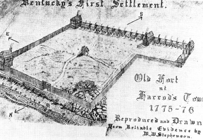 of what the place might have looked like from the book. And in this
little book (actually 616 pages and XXII Chapters, makes this a good size
book, including all the footnotes) we get a few more renditions of the
forts, sorry, stations. And a few pics of the boats that ran the
river, and all sorts of other goodies, that I've spread throughout the
homestead (with appropriate reference to the book, as well.)
of what the place might have looked like from the book. And in this
little book (actually 616 pages and XXII Chapters, makes this a good size
book, including all the footnotes) we get a few more renditions of the
forts, sorry, stations. And a few pics of the boats that ran the
river, and all sorts of other goodies, that I've spread throughout the
homestead (with appropriate reference to the book, as well.)
So Chinn has done a good job. The detail is, at times, overwhelming, but hay, that's what history is, sometimes. The footnotes, are almost better than the text, if you get what I mean. It's like that little bit of extra information that gets in there, without really knowing where to put it, like that fiction writer on Cape Cod who footnotes the footnotes in some bizarre act of artistic liberally applied literary license. (And if you don't know who I mean, forget about it. You don't want to know.)
The piece of the puzzle that always seems to get lost in these history lessons, is the craft of land ownership. Some guys could just get as much as they wanted, and Chinn goes into it a bit, but perhaps not enough. The landed gentry started in Kentucky, some would say, and perhaps that needs a little bit more explaining. OK, maybe it was Virginia, but from the map, they're pretty close.
Trade routes, as one can imagine, were pretty important. 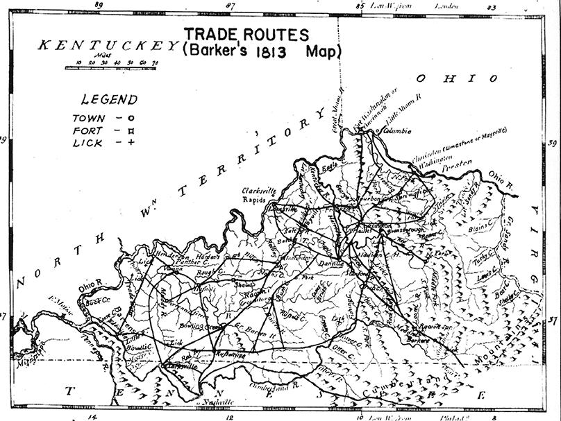 This
web of roads (pg 364)was nicely detailed. We got all kinds of routes
laid out, including the Mary Ingles escape route from the Indians detailed
on page 374, that brought her through the mountains to ol' Virginnie.
Now, this web, was the real web for them folks, not this virtual thing
we go going. So it's nice to know, real roads, real people walking
them, and hell bent for survival. Don't think I could have survived,
sure glad the triple greats did.
This
web of roads (pg 364)was nicely detailed. We got all kinds of routes
laid out, including the Mary Ingles escape route from the Indians detailed
on page 374, that brought her through the mountains to ol' Virginnie.
Now, this web, was the real web for them folks, not this virtual thing
we go going. So it's nice to know, real roads, real people walking
them, and hell bent for survival. Don't think I could have survived,
sure glad the triple greats did.
Now, I've been thinking what did this land smell like.
And I got to think it was the picturesque. As shown in this pic of
D. Boone leading the virtual party through the Cumberland Gap, 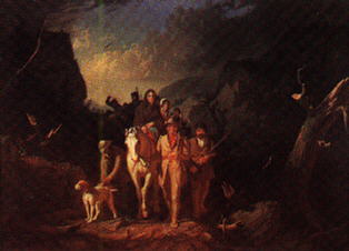 like this portrait by George Caleb Bingham (1851-52). Courtesy, Washington
University Gallery of Art, St. Louis, and the frontpage of this book we're
reviewing courtesy of Mr. George Chinn. It has it all, the foreboding,
the sensational sunset, the dark matted forest, and the ever lovin' family
dog. Now, there's a chapter, Mr. Chinn did not grace us with, and
perhaps to his credit. What did these Kentucky mountain folk have
besides their rifles to keep the Indians at bay. My guess is they
had the loudest barking dawgs one could find, or they lived the shortest
lives. Chapter XXIII?
like this portrait by George Caleb Bingham (1851-52). Courtesy, Washington
University Gallery of Art, St. Louis, and the frontpage of this book we're
reviewing courtesy of Mr. George Chinn. It has it all, the foreboding,
the sensational sunset, the dark matted forest, and the ever lovin' family
dog. Now, there's a chapter, Mr. Chinn did not grace us with, and
perhaps to his credit. What did these Kentucky mountain folk have
besides their rifles to keep the Indians at bay. My guess is they
had the loudest barking dawgs one could find, or they lived the shortest
lives. Chapter XXIII?
So, overall, this is a four Bear Flag book. Lots
of good detail, perhaps too much, good pics, great set of maps, and maybe
more about the land. Or hay, more about the river, too.