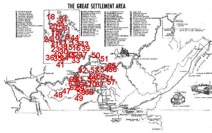
Map from "Kentucky:Settlement and Statehood 1750-1800"
by George Morgan Chinn, a publication by The Kentucky Historical Society,
Franfort, Kentucky, 1975
| ADAM'S (GEO) | Garrard Co |
| ARMSTRONG'S STATION | On the Indiana Shore in Clark Co IN at the mouth of Bull Creek, opposite the Grassy Flats, and 18-mile-Island bar in the Ohio River, 18-miles above Louisville. Blockhouse built here by Col John Armstrong between 1786-1790 to prevent the Indians from crossing the river and stealing horses from KY. |
| ARNOLD'S (JOHN) STATION | On Little Benson Creek, 7 miles above Frankfort, 1783. |
| ARRINGTON'S STATION | Southern KY, 1788. |
| ASTON'S STATION | Mentioned in Boone's autobiography, May 1782; also called Estill's. |
| A'STURGUS' STATION | 1783, on Harrod's Trace, Jefferson Co KY. 62 on Map |
| BAILEY'S STATION | Mason Co KY, 2 1/2 miles south of Maysfield, 1 mile from Washington; settled 1791. |
| BALLARD'S (BLAND) STATION | Shelby Co, usually called TYLER'S. |
| BARDSTOWN | Nelson Co, established 1788, also called BAIRDSTOWN. |
| BARNETT'S STATION | 2 miles from Hartford in Ohio Co; settled by Col. Joseph Barnett before 1790. |
| BELL'S STATION | Madison Co. |
| BLACK'S STATION | before Dec 1794; Fayette Co, on waters of Clear Creek. |
| BLOCKHOUSE ON BIG SANDY RIVER | Near or above Louisa, Lawrence Co. |
| BLUE LICKS - UPPER & LOVE | See later. 56 on Map |
| BOILING SPRING | Mercer Co, near or in Harrodsburg, 1775, one of the 4 settlements which were represented in the Transylvania legislative body at Boonesboro. |
| BOONE (GEORGE) STATION | 2 1/2 miles NW of Richmond. |
| BOONE'S (SQUIRE) STATION | Called Squire Boone's station - see later. 64 on Map |
| BOONE'S STATION | On Boone's Creek, Fayette Co, about 10 miles SE of Lexington and 5 miles NW from Boonesboro; settled by & named after Daniel Boone about 1783 or 1784, who lived there until he moved to Maysville, before Feb 3, 1786. |
| BOONE'S STATIONS | See Boonesboro. |
| BOONESBORO | on west bank of KY river in Madison Co; settled by Daniel Boone who began the fort on April 1st, finished it on 14 June 1775. |
| BOSLEY'S STATION | 3/4 mile above the main fork of Well's Creek, near Washington in Mason Co, before 1793. |
| BOWMAN'S STATION | 6 miles E of Harrodsburg,x settled in 1779 by 30 families under Col. Abram Bowman. He soon moved to Fayette Co. 8 on Map |
| BRASHEARS' STATION | At mouth of Floyd's Fork, Bullitt Co, 1779. 63 on Map |
| BRYAN'S STATION | Fayette Co, about 5 miles NE of Lexington, on the southern bank of the north fork of Elkhorn; settled by the Bryans in 1779, but a cabin had be en built by Joseph Bryan, a son-in-law of Col. Daniel Boone in 1776. |
| BUCHANAN'S STATION | 1 mile W of Germantown, Bracken Co, where geo Humlong recently lived. BULLITT'S LICK, on N side of Salt river, 3 miles from Salt River and same distance from Shepherdsville in Bullitt Co; discovered by Capt. Thos Bullitt in 1773; t he only place where salt was made about the Falls in 1780-1, according to Bland Ballard's description. |
| BURNT STATION | On or near Simpson's Creek, Nelson Co. |
| BUSH (WM) STATION OR SETTLEMENT | Clark Co, near Boonesborough. |
| BYNE'S STATION | Settled by Edmund Byne on North Fork in Mason Co. |
| CAMP KNOX | E part of Green Co where in June 1770, Col. James Knox, with 22 men (called the "Long Huners" with 4 pack-horses, encamped. |
| CAMPBELL'S STATION | On the Dry Ridge in now Grant Co, 3 miles N of Williamstown, 33 miles from the south of Licking; settled sometime before 1792. |
| CANE RUN | A Presbyterian meeting house in 1784, in then Lincoln Co. |
| CARPENTER'S STATION | In the knobs of Green River, about 2 miles W of Hustonville in Lincoln, Co, about 1780. 35 on Map |
| CARTWRIGHT'S STATION | Settled 1779. |
| CASEY'S (Col. Wm) STATION | Lincoln Co, 3 miles W of Stanford, & 7 miles E of Danville, on Hanging Fork of Dick's River. 36 on Map |
| CASSIDY'S STATION | Fleming Co; settled by Michael Cassidy. |
| CLARK'S STATION | Mason Co, settled 1785. |
| CLARK'S STATION | On Clark's run, a branch of Dick's River; settled by GEO CLARK before Nov 1779. 16 on Map |
| CLARKSVILLE | In Indiana, opposite Louisville, laid out by Gen. Geo Rogers Clark. |
| CLEAR'S STATION | Bullitt Co. |
| COLLINS' STATION | On Rockcastle River. |
| COOPER'S STATION | On Cooper's run, Bourbon Co, 2 miles from KISER'S. |
| CORN ISLAND | In Ohio River, opposite Louisville where Gen. Geo Rogers CLARK build a fort June 1778, raised several crops of corn; had several acres of rich land - now all washed away. |
| COX'S STATION | Nelson County, near KINCHELOE'S Station. 58 on Map |
| CRAB ORCHARD | Lincoln County, 12 miles from Lancaster, 10 miles from Stanford, on the old pioneer road to Cumberland Gap. |
| CRAIG (ELIJAH) STATION | 5 miles from Versailles; 1783. 55 on Map |
| CRAIG'S STATION | On Gilbert's creek, few miles E of Lancaster in Garrard Co; settled by Rev Lewis CRAIG 1780. 43 on Map |
| CREWS'(DAVID) STATION | Madison Co, 1781. |
| CROW'S STATION | In THEN Lincoln Co, 2 miles E of Danville. 15 on Map |
| CURTIS' STATION | Mason Co. |
| DANVILLE | In Boyle county; laid off as a town by Walker DANIEL 1781. |
| DAVIESS' (JAMES) STATION | About 5 miles W of Whitley's. 33 on Map |
| DAVIS' STATION | Southern KY, probably in Logan or Warren Co. |
| DOUGHERTY'S STATION | Boyle Co on CLARK'S run, 1 1/2 miles below Danville. |
| DOVER STATION | Garrard Co, waters of Dick's River. |
| DOWDALL'S STATION | On Salt River, before 1784. |
| DOWNING'S STATION | E of and near Dick's River, not far from Danville. |
| DRENNON'S LICK | Henry County, near KY River. |
| DUTCH STATION | Jefferson Co, on Beargrass creek, 1780. 11 on Map |
| ELK FORK OF RED RIVER | Logan Co, several settlements on, 1785. |
| ELLIS' STATION | At Ellisville, Nicholas Co. |
| ENGLISH'S STATION | On south bank of Dick's River, Lincoln Co, 3 miles E of Crab Orchard. 39 on Map |
| ESTILL'S NEW STATION | 5 miles SE of Richmond. |
| ESTILL'S STATION | On Muddy creek, 3 miles S of Richmond in Madison Co; settled by Capt. James ESTILL, before 1781. |
| FALLS OF THE OHIO | First fort was built on Corn Island, opposite L'ville in June 1778; in the fall of 1778 or spring of 1779, a rude stockade was raised near a ravine where, in 1838, Twelfth St in Louisville terminated at the Ohio River. |
| FEAGAN'S STATION | Mason Co, 1 1/2 to 2 miles E of Germantown. |
| FIELDS' (WM) STATION | 1 1/2 miles W of Danville. 30 on Map |
| FINNEY, FORT | Original name of the Fort where lower end of Jefferson-ville, IN now stands, at the Falls of the Ohio. |
| FINN'S STATION | In Jefferson or Spencer Co, settled before 1780. |
| FISHER'S (STEPHEN) GARRISON | Not far from Danville. 13 on Map |
| FLEMING'S | (Col. John) Station Fleming C1o, 1790 |
| FLORER'S STATION | On S bank of Dick's River, Lincoln Co, 3 miles E of Crab Orchard. |
| FLOYD'S FORK STATION | Oldham Co near Pewee Valley, 18 miles E of Louisville. |
| FLOYD'S STATION | First at the mouth of the Beargrass, in Louisville, corner 3rd St and Ohio River. |
| FLOYD'S STATION | On the Middle Fork of Beargrass Creek, 6 miles from the Falls of the Ohio; settled by Col. John FLOYD, 1775. 61 on Map |
| FONTAINBLEAU | About 3 miles below Harrodsburg, on the bank of the Salt River; a mill was built there at an early day. |
| FORKS OF DICK'S RIVER | Presbyterian preaching place in 1784, in NOW Lincoln Co. 44 on Map |
| FORKS OF ELKHORN SETTLEMENT | Scott Co. |
| FOX'S (ARTHUR) STATION | Same as Washington. |
| GARRARD'S STATION | Hamilton Co OH, on Little Miami; April, 1796. |
| GEORGETOWN | Scott Co, formerly at McCLELLAND'S Fort (see later). |
| GILMER'S LICK | 7 miles from Whitley's Station, Lincoln Co. |
| GILMORE'S STATION | 12 miles E of Mountsterling, Montgomery Co. |
| GIVENS' (SAMUEL) STATION | 1 1/4 milese SW of Danville, on a branch of Clark's run; settled before Feb 1780, afterwards called JOHN REED'S STATION. 17 on Map |
| GLOVER'S STATION | On the Green River, where Greensburg now stands, 1780. |
| GOAR'S STATION | Franklin Co, N side of Elkhorn Creek. |
| GOODWIN'S STATION | On the Rolling Fork, 1780. |
| GORDON'S STATION | 1779, Mercer Co. (5 on map) |
| GRANT'S LICK | Campbell Co, 5 miles from Alexandria, on road to Falmouth; salt made there before 1800. |
| GRANT'S STATION | Settled by Col. John GRANT, 1779, who abandoned it in 1780 and moved back to NC; but returned and re-settled it 1784. Within 5 miles NE of Bryan's Station, near where Lowe's is, on KY Cen RR near Fayette and Bourbon line. |
| GREAT CROSSING STATION | Scott Co, abt 2 miles W of Georgetown; same as Col. JOHNSON'S. |
| GRUBB'S STATION | Settled by Capt. Higgason GRUBBS, on Muddy Creek, Madison Co before Oct 1792. |
| HAGGIN'S STATION | See TRIGG'S Station to follow. 31 on Map |
| HARBESON'S STATION | Probably in E part of Washington Co, on road from Harrodsburg to Bardstown. 24 on Map |
| HARDIN'S STATION | Same as Hardinsburg above. |
| HARDINSBURG | County seat of Breckinridge Co., originally a station erected by Capt. HARDIN; laid out as a town in 1782. 47 on Map |
| HARLAN'S STATION | On Salt river in Mercer Co, 7 miles SE from Harrods- burg & 3 miles SW of Danville; built by Major Silas HARLAN in 1778. 21 on Map |
| HARRISON'S STATION | 2 miles from HIGGIN'S Fort, about 3 miles from Cynthiana in Harrison Co, before 1786. |
| HARROD'S STATION | 6 miles E of Harrodsburg in Mercer Co, on the present road to Danville; settled by Col. James HARROD. 10 on Map |
| HARROD'S TOWN, or HARRODSBURG STATION | Where Harrodsburg now stands in Mercer Co, settled by James HARROD 1774. The Fort - located on the hill which, in 1834, was occupied by the seminary bldg., and which included a considerable spring of water at its foot, was begun during the winter of 1775-6, but not finished until the next season. |
| HARTFORD STATION | Where Hartford, OH is, before 1790. 48 on Map |
| HART'S or WHITE OAK SPRING STATION | 1 mile above Boonesboro, in same KY River bottom, Madison Co, settled 1779 by Nathaniel HART, and some families from PA. |
| HAZEL PATCH | On the Cumberland Gap road, in Laurel Co. |
| HELM'S STATION, HAYCRAFT'S STATION, HYNES STATION | Settled by Capt. Thomas HELM in 1780, on the spot now occupied by the late Gov. John L HELM'S residence; the 2nd, named after Samuel HAYCRAFT, was on the hill above the cave spring; while HYNE'S, settled by Capt. Andrew HYNES, occupied the other angle of the triangle where Elizabethtown now stands; they were one mile apart. |
| HIGGIN'S BLOCKHOUSE | On the bank of Licking, 1 1/2 miles above Cynthiana Harrison Co, opposite mouth of Seller's Run; before 1786. |
| HINKSTON'S STATION | Harrison Co, on South Licking, 1 1/2 miles above Higgin's Blockhouse, a short distance below Hinkston Creek; was first settled by Isaac RUDDLE and others and called Ruddle's Station until "Taken by the Indians" in 1780; when re-settled, it was most often called Hinkston's, after John HINKSTON, the most prominent of the re-settlers. |
| HOBSON'S CHOICE | The camping ground of Gen. WAYNE, 1793, on the Ohio river blow (but now in) the city of Cincinnati - the very spot now occupied by the gas works, but reaching above and below that. 50 on Map |
| HOGLAND'S STATION | Jefferson Co, on Beargrass, 1780. |
| HOLDER'S (JOHN) STATION | On KY river, 2 miles below Boonesboro. |
| HOOD'S STATION | In Clark Co, before 1792. |
| HOY'S STATION | In Madison Co. |
| HUSTON'S STATION | In 1776, present site of Paris in Bourbon Co. |
| IRISH STATION | Nicholas Co, 5-6 miles S of Lower Blue Lick, on the road to Millersburg. |
| IRISH STATION | Betwen Danville and mouth of Dick's River. |
| IRVINE'S STATION | Near where Richmond now stands, Madison Co, established by Col. Wm IRVINE and his brother Capt. Christopher IRVINE; 1778-9. 23 on Map |
| JEFFERSON FORT | Ballard Co, on the Mississippi River, about 5 miles below the mouth of the Ohio; established by Gen. George Rogers CLARK, within the Chickasaw country in 1780; abandoned or evacuated in the spring of 1781 because it afforded no security to the western settlements. |
| JOHNSON'S (COL ROBT) STATION | At the Great BUffalo Crossings on North Elkhorn, Scott Co, settled winter of 1783-4. |
| KELLAR'S STATION | Jefferson Co, before 1780. |
| KENNEDY'S STATION | Garrard Co, between Paint Lick and Dick's River. |
| KENTON'S (JOHN) STATION | 1/2 mile SE of Washington in Mason Co. 65 on Map |
| KENTON'S (SIMON) STATION | Several blockhouses built by him who brought to them from PA his father's family & remained with them until July 1784. |
| KENTON'S STATION | 3 miles SW of Limestone, now Maysville, and 1 mile N of Washington in Mason Co, settled by Simon KENTON 1784. |
| KILGORE'S STATION | 1782, N of Cumberland River, S side of Red River, attacked by Indians, same yr. and broken up. Probably in southern part of Logan co near the state line, or may be in TN. (Addition by Mark Lowe This is not in Robertson County, Tennessee formerly Tennessee County, North Carolina. Thomas Kilgore is buried near Cross Plains, TN. The cave where he hid before building a station is still visited.) |
| KINCHELOE'S STATION | On Simpson Creek, Spencer Co. 59 on Map |
| KNOB LICK | Lincoln CO, 5 miles S of Danville, settled 1776 by Isaac SHELBY. |
| KUYKENDALL'S (MOSES) STATION | 1782, Jefferson Co, waters of Beargrass. |
| LEACH'S STATION | In Bracken Co. |
| LEE'S STATION | Mason Co between Maysville and Washington; settled by Gen. Henry LEE 1785, and still the home of his descendants. |
| LEESTOWN | On E bank of KY River, 1 mile below Frankfort - settled 1776 by Hancock LEE, Cyrus McCRACKEN (father of Capt. Virgil McCRACKEN, after whom McCracken Co was named) - and others, who raised cabins there. |
| LEITCH'S STATION | About 6 miles above the mouth of the Licking, on the E bank in now Campbell Co; setled in 1790 by Maj. David LEITCH (after whom Litchfield, Grayson Co, was named). |
| LEWIS'S STATION | Re-settled by Gen. LEWIS in 1789, formerly called Geo CLARK'S Station - where Lewisburg now is, Mason Co, 9 miles from Maysville. |
| LEXINGTON | On the Town fork of Elkhorn, Fayette Co, settled by Col. Robert PATTERSON, April 1, 1779. |
| LIBERTY FORT | On Salt Rivr in Mercer Co, 3/4 mile below McAFEE'S Statin. |
| LICKING STATION | Harrison Co, probably near Lair's or may be nearer to Cynthiana. |
| LIMESTONE | See Maysville. |
| LINDSAY'S STATION | Scott Co near Lecompt's Run. |
| LINN'S STATION | On Beargrass, Jefferson Co, about 10 miles from Louisville, before 1780. |
| LITTELL'S STATION | Pendleton Co, on Fork Lick, a west branch of South Licking into which it empties just below Collinsville (Or Morgan's on KY Central RR). |
| LOCUST THICKET FORT | Madison Co before 1780. |
| LOGAN'S FORT | Same as St Asaph, 1 mile W of Stanford, in Lincoln Co, settled by Col. Benj. LOGAN 1775. |
| LOUDON'S STATION | 30 miles from mouth of KY River, probably in Henry Co. |
| LOUISVILLE | At the Falls of the Ohio, Jefferson Co, laid off as a town by Capt. Thos. BULLITT, Aug 1773; first settlement was on Corn Island, near the KY shore, in the spring of 1778; in the fall of that yr., a blockhouse was built on the main short, and in 1782 a larger fort called Fort Nelson. |
| LOWER BLUE LICKS | Nicholas Co, in sight of where the Maysville & Lexington turnpike crosses Licking River, discovered 1773. |
| LYNCH'S STATION | Near Shelbyville, same as Squire Boone's. |
| MANCHESTER or MASSIE'S STATION | 12 miles above Maysville on the N bank of the Ohio River. |
| MANN'S LICK | A salt station before 1786, on S side of and close to Salt River in Bullitt Co, few miles from Shepherdsville. |
| MARBLE CREEK STATION | 7 miles from Boonesboro. |
| MARTIN'S STATION | Established by John MARTIN who built a cabin in 1775, 5 miles from Ruddle's Station, on Stoner, about 3 miles below Paris in Bourbon Co, settled 1779. 54 on Map |
| MASTERSON'S (JAMES) STATION | 5 miles NW of Lexington. The first Methodist E Church building in KY was erected here - a plain log structure - in 1790or earlier, and in 1871 was still standing. |
| MAULDING'S STATION | Established 1780 on Red River, Logan Co. |
| MAY'S LICK SETTLEMENT | At Mayslick, Mason Co. |
| MAYSVILLE | On the Ohio River, at the mouth of Limestone Creek, Mason Co, settled 1784, blockhouse built by Edward WALLER, John WALLER and George LEWIS of Virginia. |
| McAFEE'S STATION | Mercer Co, 6-7 miles from Harrodsburg on Salt River, about ¼ mile above Providence Church; settled by McAfee brothers in 1779. 18 on Map |
| McAFFEE'S STATION (WILLIAM) | On Shawnee run, about 1 mile W from Harrodsburg, at the mouth of the Town branch. 19 0n Map |
| McCLELLAND'S FORT or STATION | Where Georgetown now stands in Scott Co, settled 1776 by John, Alexander and Wm McCLELLAND, and their and other families from Hinckston's Station and Drennon's Lick. 60 on Map |
| McCONNELL'S STATION | Settled by Wm McCONNELL 1783 or earlier, at the royal spring near (now in) Lexington, was not so fortified as to be regarded as a regular station, and was soon merged in Lexington.67 on Map |
| McCORMICK'S STATION | On top of first ridge N or NW of Knob Lick fork of Hanging Fork of Dick's River.40 on Map |
| McFADDEN'S STATION | 4 miles above Bowling Green on Big Barren River, Warren Co, settled by Andrew McFADDEN 1785. |
| McGARY'S (Maj. HUGH) STATION | Mercer Co, at the headspring on Shawnee Run, 5 miles NNE from Harrodsburg. 4 on Map |
| McGEE'S STATION/COVE SPRING | On Cooper's run, in SE part of Fayette Co, on or near Tate's Creek road from Lexington to Richmond; sometimes called the "Old Station", settled before 1780. |
| McGUIRE'S STATION | Same as McGEE'S, so called, sometimes, because James McGuire was prominent there in 1780. |
| McKINLEY'S BLOCK HOUSE | On the old buffalo trace S of Washington, Mason Co where David HUNTER lived 1873; built by Jas Mc- Kinley 1785. |
| McKINNEY'S STATION | Settled by Archibald McKINNEY before 1792, Lincoln Co, on McKinney's branch of Hanging Fork, about 2 miles from Green River, 9 miles SW from Stanford & about 4 miles NE of Hustonville. 45 on Map |
| McMILLIN'S FORT | Bourbon or Harrison Co, 1779. |
| MEAUX'S STATION | Probably Boyle or Mercer Co, 1789. |
| MEEK'S STATION | Waters of Drennon's Lick, 20 miles from the Ohio river at the mouth of 18 mile Creek. |
| MEREFORD'S (GEO) STATION | 2 1/4 miles S of Maysville, Mason Co, 1787 66 on Map |
| MIDDLE STATION | Jefferson Co before 1787. |
| MILLER'S STATION | Settled 1784 by John MILLER, about 1 mile from Hinkston Creek towards Blue Licks, 1 mile NE of Millersburg. |
| MILLS' STATION | Supposed to be in Greenup or Lewis Co; Wm THOMPSON of White Oak, Greenup Co, who died 7 May 1867, age 77, settled there in 1790 with his father. |
| MONTGOMERY'S STATION | Lincoln Co, on headwaters of Green River, 12 miles SW from Logan's Fort; 2 1/2 miles from Petit's Station; settled by Wm MONTGOMERY, the father-in-law of Gen. Ben LOGAN and sons 1780. 34 on Map |
| MORGAN'S STATION | On Slate creek, 7 miles E of Mt Sterling, in now Bath Co, settled before 1793. 57 on Map |
| MUD GARRISON | Where Shepherdsville now stands in Bullitt Co, midway between Bullitt's Lick and the Falls of Salt River, settled in or before 1778. |
| MUDDY RIVER LICKS | N of Russellville, Logan Co and Butler Cos,between 1780 and 1 784. |
| NELSON FORT | Louisville, corner of 9th St and Ohio River. 52 on Map |
| NEW HOLLAND | Jefferson Co, before 1784. |
| NONSENSE FORT | Bullitt Co. |
| OLD TOWN | A name by which Harrodsburg was known at an early day. |
| OLD TOWN | Greenup Co, scene of a great battle by Indians. |
| OWEN'S (BRACKET) STATION | Near Shelbyville, 1782. |
| OWINGS' STATION | On road from Lexington to Paris. |
| PAINT LICK STATION | Garrard Co, near Madison Co line. |
| PAINTED STONE | Some doubt as to locality, believed to be another name for Squire BOONE'S Station on Clear Creek, near Shelbyville, Shelby Co, certainly Squire Boone's military headquarters June 1780. |
| PARIS | Formerly HOUSTON'S STATION Bourbon Co, established 1789 under the name of HOPEWELL, afterwrds called BOURBONTON, and finally Paris. |
| PETIT'S STATION | Lincoln Co, 2 1/2 miles from Montgomery's Station, on headwaters of Green River, 16 miles from Logan's Fort. 41 on Map |
| PHILLIP'S FORT | Larue Co, N side of Nolin Creek, 1 1/4 miles from Hodgenville; s ettled by Philip PHILLIPS 1780-1. |
| PITTMAN'S STATION | Green Co, Right bank of Green River, near the mouth of Pittma n's Creek, 5 miles W of Greensburg, settled in fall of 1779 or spring of 1780. 49 on Map |
| POND STATION | McLean Co, 4 miles SW of Calhoon, 1790. |
| POPLAR LEVEL | Jefferson Co, before 1784. |
| PORT WILLIAM | Now Carrollton, Carroll Co, at mouth of KY River, laid out in 1792 ; a blockhouse built in 1786 or 1787 by Capt. ELISTON. |
| REED'S (JOHN) STATION | Near Danville, same as GIVENS'. |
| ROGERS' STATION | Nelson Co near the Beech Fork, 1780 |
| ROGERS' STATION | Towards Strode's station, Clark Co. |
| RUDDLE'S STATION | On E bank of South Fork of Licking River, 3 miles below the junction of Hinkston and Stoner's Branches; about 7 miles from Paris, Bourbon Co, settled 1777 by Isaac RUDDLE; captured by the Indians and destroyed in 1780, rebuilt by John Hinkston and others, and called Hinkston's Station. 53 on Map |
| RUSSELLVILLE | Logan Co, settled 1780. |
| SALT RIVER GARRISON | Before 1780. |
| SANDUSKY'S STATION | On Pleasant Run in Washington Co, settled by James SANDUSKY or SODOWSKY 1776; in 1786 or 87 he removed to Cane Ridge in Bourbon Co and settled another station, which was probably known by the name of CANE RIDGE. 68 on Map |
| SCOTT'S (John) STATION | 5 1/2 miles NE of Cynthiana, Harrison Co. |
| SCRIVNER'S STATION | Madison Co. |
| SHALLOW-FORD STATION | Madison Co. |
| SKAGG'S STATION | On Brush creek, Green Co, about 1781. |
| SLATE BLOCKHOUSE | At the old Slate Furnace, Bath Co, about 1788. |
| SMITH'S STATION | On road from Danville to mouth of Dick's River. 7 on map |
| SPRING STATION | Jefferson Co, 1784. |
| SQUIRE BOONE'S STATION | Shelby Co near where Shelbyville now stands, on Clerk Creek, a branch of BRASHEARS' Creek, 1780 or before. |
| ST ASAPH/LOGAN'S FORT | Lincoln Co, 1 mile w of Stanford; 1775. 32 on Map |
| STATION CAMP CREEK | Jackson and Estill Counties. |
| STATIONS | on Beargrass Creek 6, in 1780, with a population of 600 men |
| STEVENSON'S STATION | On Paint Lick creek, probably Garrard Co. |
| STOCKTON'S (Geo) STATION | In sight of Flemingsburg, Fleming Co; 1787. |
| STRODE'S STATION | 2 miles from Winchester, Clark Co, 1779.71 on Map |
| STROUD'S STATION | Mason Co, on North Fork of Licking, at the mouth of Stroud's Run, 1785. More correctly written STRODE. |
| STRUBEN FORT | Falls of the Ohio, 1790, originally called Fort FINNEY, now Jeffersonville, IN. |
| STURGUS' STATION | Jefferson Co, in or before 1784. |
| SULLIVAN'S (Daniel) | Jefferson Co, before 1784. |
| SULLIVAN'S NEW STATION | Jefferson Co, before 1784. |
| SULLIVAN'S OLD STATION | Before 1780, Jefferson Co; 5 miles SE of Louisville, on the Bardstown Road. Elisha APPLEGATE, then still living in Nov 1872 was born there 1781.69 on Map |
| SULLIVAN'S STATION | Jefferson Co, Beargrass, 1780. |
| SUMMIT STATION | Nicholas Co, 12 miles from Lower Blue Licks. |
| TANNER'S (JOHN) STATION | 6miles NW of Richmond. |
| TANNER'S STATION | Where Petersburg now is, Boon Co, 1785. |
| TANNER'S STATION | Lower Blue Licks, Nov 1784. |
| TAYLOR'S CREEK STATION | Probably Campbell Co on Taylors Creek. The Cin- cinnati Centinel of the North-West Mar 12, 1796, says John Campbell lived there. |
| THE LITTLE FORT | Same as TWETTY'S, formed 1775. |
| THOMPSON'S STATION | Settled by Robert Thompson 1790, on the Middle Fork of Elkhorn, 3 miles below Lexington, Fayette Co. |
| TODD'S STATION | Jessamine Co, not far from Keene, about 10 miles SW from Lexington; settled by Levi TODD 1779, who afterwards removed to Lexington as a place of greater safety. 70 on Map |
| TRIGG'S STATION | 4 miles NE of Harrodsburg, Mercer Co, on Cane Run, 4 miles from its mouth at Dick's River; settled 1780 by Col. Stephen TRIGG, and called Viney Grove, because of the number of large grape-vines. John HAGGIN lived there, and it was sometimes called Haggin's Statioin. 6 on map |
| TWETTY'S FORT | The first fort in KY, 5 miles S of Richmond. |
| TYLER'S STATION | Named after Capt. Robert TAYLOR, Tick Creek, 4 miles E of Shelbyville. |
| UPPER BLUE LICKS | Licking River, Nicholas Co, 12 miles from Flemingsburg and 18 miles from Carlisle. |
| VANCE'S STATION | Green River, 15 miles from its mouth, before Apr 1780. |
| VANCOUVER'S (CHARLES) FORT | Fork of Big Sandy River; settled 1789, abandoned 1790. |
| VANMETER'S (JACOB) FORT | Hardin Co before 1790. |
| VIENNA STATION | McLean Co, falls of Green River, now Calhoon. |
| VINEY GROVE | See above. |
| WADDINGTON'S | A mistake for WORTHINGTON'S Station, which see. |
| WARING'S STATION | Mason Co, nearly 2 miles from Maysville, short distance W of Lexington Turnpike; settled Feb 1785 by Col. Thos. WARING. |
| WARNER'S STATION | Otter Creek, Madison Co. |
| WARREN'S (THOS) STATION | Madison Co. |
| WASHINGTON | Mason Co, 3 1/2 miles SW of Maysville; settled by Simon KENTON 1784; laid out as town in 1786, by Rev Wm WOOD and Arthur FOX, Sr. (now Cincinnati, OH. 51 on Map |
| WELLS' (SAMUEL) STATION | 3 1/2 miles NW of Shelbyville. |
| WELLS' STATION | W part of Mason Co. |
| WHALEY'S STATION | Mason Co. |
| WHIPPOORWILL CREEK | Logan Co, settled 1784 by the MAULDINGS. |
| WHITAKER'S STATION | Bullitt Co, settled by Cap Aquilla WHITAKER, the hero of the fight at the foot of the Falls of the Ohio Mar 1, 1781. |
| WHITE OAK SPRING (or HART) STATION | See that listing. |
| WHITLEY'S STATION | Lincoln Co, 2 miles SW of Crab Orchard. 1779. 37 on Map |
| WILLIAM'S (DAVID) STATION | 6miles NE from Harrodsburg. |
| WILSON'S STATION | Mercer Co, branch of Salt River, 2 miles NW of Harrodsburg. 20 on Map |
| WILSON'S STATION | Lincoln Co, fork of Clark's run, 1785. |
| WOODS' (JOHN) STATION | Madison Co. |
| WORTHINGTON'S STATION | Also called Fort. 4 miles S E of Danville, Lincold Co; 1779, by Capt. Edward WORTHINGTON, one of the "Long Hunters". Sometimes called Waddington's. 38 on Map |