
Posted on July 17, 1998
TO ANTICIPATE IMPACTS OF RECLAMATION OF JAKARTA BAY
- A groundwater conservation's perspective - *)
by : Soetrisno S., Satriyo H., and Haryadi T. **)
4. Anticipation
According to the groundwater conditions as above mentions, water supply on the future reclamation land will not be able to rely on the groundwater resources. Moreover those reclamation activities should comprise of a prevention on groundwater degradation in Northern Jakarta, especially to prevent salt water intrusion, restoring groundwater level, and monitoring of land subsidence.
Those activities comprise of:
- Developing ponds or artificial lakes to store surface run off during rainy season, act as retarding basin. This storing water is intended to recharge shallow aquifer. While developing shallow or deep injection wells will also create a direct groundwater recharge in the each aquifer system (Fig, 3). This recharge will flush the brackish groundwater containing in the aquifer toward the sea.
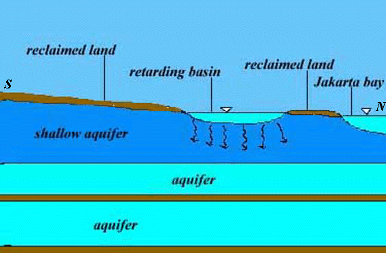
Fig. 3. Artificial lakes act as retarding basin in reclaimed land.
- Creating the groundwater extraction barrier, by means of a series of wells drilled parallel to the coastal line as long as 32 km. Those wells will continuously extract brackish groundwater from the aquifer, such that a zone of groundwater depression occurred which prevents sea water flows toward inland, and to maintain the stability of hydrostatic balance between salt and fresh water. The pumped water discharging back to the sea (Fig. 4).
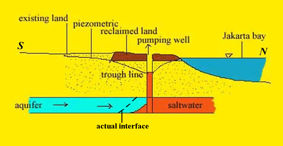
Fig. 4. Effect of pumping to saline-fresh water interface
Result of simulation using MODFLOW software shows that if groundwater is pumped out with total discharge of 4.67 million m3 year-1 from series of well parallel to shore line, then cone of depression with the deepest of 4 m below sea level occurred and act as extraction barrier to prevent salt water moving to inland (Fig. 5).
- Development of monitoring stations for land subsidence comprise of bench mark, monitoring wells for all aquifer systems, pore water pressure meter, and ekstensometer. Those proposed stations are located on Cengkareng, Pasar Ikan and Sunter area.