
Posted on July 17, 1998
TO ANTICIPATE IMPACTS OF RECLAMATION OF JAKARTA BAY
- A groundwater conservation's perspective - *)
by : Soetrisno S., Satriyo H., and Haryadi T. **)
A b s t r a c t
The existing land and population of Greater Jakarta are highly relied on groundwater for providing their water supply. In the year 1995, deep groundwater abstraction was calculated 54 million m3 year-1 which was about 50% higher than that of registered wells (32.2 million m3 year-1). Only 20% of the Jakarta's population is served by municipal water supply.
The highly dependent on groundwater has led to the degradation of both its quantity and quality, primarily in the northern part of Jakarta, such as lowering of groundwater head, about 2 - 4.6 m year-1, salt water intrusion, and land subsidence which is highest recorded of 34 cm year-1 between 1979 - 1991 years of observation.
The addition of 2700 ha of land which will be claimed from reclamation certainly will give impacts to groundwater setting, such as changing in fresh-salt water interface, recharge - discharge pattern, water balance, and total of water supply.
From groundwater conservation's perspective, water supply for any activities and population on reclaimed land, therefore, must not rely on groundwater resources and efforts to restore the groundwater condition should be integrated part of reclamation activities. Empowering municipal water supply and using surface water might be the best solution for providing water in reclaimed land.
Creating retarding basins and extraction barrier along the shore line, based on result of simulation model, will give positive impacts to groundwater conservation program in North Jakarta.
___________________________
*) Paper presented at Workshop on Coastal and Nearshore Geological/ Oceanographical Assessment of Jakarta Bay: A Basis for Coastal Zone Management and Development, Jakarta, June 25 - 28, 1997.
**) Directorate of Environmental Geology, Jln. Diponegoro 57, Bandung 40122, Indonesia, Telp. +62 22 772603, Fax. +62 22 706167, E-mail: geoling@dgtl. dpe.go.id URL: http://www.dgtl.dpe.go.id.
1. Introduction
Greater Jakarta area will soon extend 2700 ha more, through reclamation of Jakarta Bay. There was a great discussion on that reclamation planning among the experts, concerning the impacts to various aspects of environment, physical and social such as flood, coastal abrasion, changing of sea current, and social impacts. However, focused on water supply in reclaimed land afterward and relation to groundwater resources is still lacking.
As the reclamation planning is becoming political will of the government, is to be an obligation for expersts on their own field respectively, to contribute those planning in order to minimise any negative impacts which might be happened.
The authors are not pretending to be an expert, however, based on our knowledge which we have, the paper intend to give inputs to the decision makers, particularly from groundwater conservation perspective, what anticipation should be taken, hence, the reclamation is still keeping groundwater resources in North Jakarta sustainable, or even better than the present time. Since we don’t have any access to detail planning of the reclamation, all impacts and anticipation which are described in this paper, are merely based on hypothetical background.
The addition of land in North Jakarta will give logical consequences on increasing demand of water supply in the reclaimed land. The modern business centers, appartments, housing complexes, and other public utilities which will be build in the reclaimed land, will need a lot of water and increase water supply in Greater Jakarta correspondingly.
Since the existing land and population of Greater Jakarta at present are still highly relied on groundwater, therefore the water supply for reclaimed land will be a crucial part of the development of the land. Its development relates to water supply should avoid any increasing degradation to the groundwater resources of Jakarta basin, particularly in the northern part.
2.Groundwater Setting and Present Situation of Water Supply
Greater Jakarta is located in the groundwater basin which is so called the Jakarta Groundwater Basin.
The bottom of the basin is formed by impermeable Miocene sediments which also crop out at the southern boundary of the system. The basin fill which consist of marine Pliocene and Quarternary sand and delta sediments is between 0 and more than 300 m thick. The thickness of single sandy aquifer layers intercalated with a predominantly silty/clayey sequence is only between 1 and 5 m and is only 20% of the total fill. Fine sand and silt is very frequence component of aquifers (Schmidt et al, 1985)
The horizontal permeability (Kh) of tested layers was found to be between 0.1 m day-1 and 40 m day-1. Transmissivity (T) for the entire Quarternary sequence of 250 m thickness are some 250 m2 day-1 near the coast and increase to about 500 m2/day near hinge line about 20 km to the south. The vertical permeability (Kv) is estimated as varying between 1/100 and 1/5000 of the horizontal permeability. The Quarternary aquifer may generally be divided into three aquifer systems on the basis of the hydraulic characteristics and depths; these are: (1) Phreatic Aquifer System (0-40 m), (2) Upper Confined Aquifer System (40-140 m), and (3) Lower Confined Aquifer System (>140 m).
Confined aquifers may extend to Jakarta bay and Seribu Archipelago as proved by drilling in some islands (Untung Jawa, Pramuka) of archipelago and marine geology research in Java Sea (Sarmili at.al, 1996).
Under natural flow conditions the recharge area of the deep aquifer system was situated in the hilly area at elevations of between 25 and 200 m. Discharge from the confined aquifer to the natural base level in the flat coastal area occurred mainly by upward leakage, evapotranpiration and outflow to the surface water system. Today, recharge to the deep aquifer system, other than horizontal inflow, may occur throughout the city area by downward leakage, as head levels of the confined aquifer system have dropped regionally (2 - 4.6 m year-1) below the water table of the unconfined shallow aquifer system.
Piezometric head in North Jakarta changed from 12.5 m above sea level in 1910 to about sea level in 70’s, then lowered drastically to 30 - 50 m below sea level in 90’s.
Groundwater quality in general was very good at the beginning of this century but in the top layers of the coastal plain deposits was slightly brackish to saline. At present, the exploitation of deep groundwater has caused salinization of the deep aquifer, whereas the rapid urbanization and the high population densities within the urban areas have led to the contamination of the shallow aquifer.
The supply of water is a pressing problem in Greater Jakarta. The 1995 total water demand is predicted 750 million m3year-1. Although the volumes of groundwater abstracted are small in comparison to those of surface water, at present it is of considerable economic and social importance, because about 70% of the population in Greater Jakarta and the majority of the industries in Jabotabek rely on this resources.
Water demand of Greater Jakarta for various utilities, based on the recent information, is fulfilled from surface water after being treated by Jakarta Municipal Water Supply (PAM Jaya), or directly treated by people from groundwater which being abstracted through deep wells, driven wells, dug wells, and from spring water coming from West Java. At the end of 1994 PAM Jaya has supplied to 337.000 consumer, about 20% of total Jakarta population (Kirmanto, 1995). Maximum production capacity was 18.065 litre/second.
Report of Jabotabek Water Resources Management Study (JWRMS), 1994, noted that on 1990 water demand for northern part of Jakarta was 11.54 m3 sec-1 being provided by means of piping system 2.88 m3 sec-1 meanwhile the rest of demand about 8.65 m3 sec-1 was still dependent on groundwater.
The groundwater contribution to the actual supply is about 250 million m3 year-1 and is mainly abstracted from innumerable shallow wells (80%) and more than 3,000 deep wells (20%). Between 1900 and 1950, groundwater abstraction was below 10 million m3 year-1 but since that time, mainly after 1970, it has steadily increase in step with the growth in population and industrial development. In the year 1995, deep groundwater abstraction was estimated 54 million m3 year-1 which was about 50% higher than that of registered wells (32.2 million m3 year-1).
The highly demand of groundwater usage has led to lowering piezometric head and increasing salinization as mentioned above, and presumably the main cause of land-subsidence in several locations in North Jakarta. Rate of subsidence was highest recorded of 34 cm year-1 from 1979 - 1991 years of observation.
Referring to the present usage of groundwater and its impacts, therefore, to meet the demand of water needs in reclaimed land in the future must not be relied on groundwater resources anymore.
As the impacts of groundwater abstraction can be predicted, soon in 1985 Directorate of Environmental Geology (DEG) and Federal Institute of Geosciences and Natural Resources, Germany, proposed scenarios of optimisation of groundwater abstraction in Jakarta basin, based on the result of groundwater modelling.
If the total groundwater abstraction could be limited to 47 m3 year-1 and in 1995 reduced abstraction in northern part of Jakarta (an area extended to 10 km from shore line) to 10% of total abstraction, then to stop pumping in that area in 2005, hence, starting in the year 1995 piezometric head of groundwater in North Jakarta will recover and become stable at about 5 m below sea level in the year 2010 (Schmidt and Tirtomihardjo, 1986). However, to implement that scenarios was not the simple thing as figured by present usage of groundwater as mentioned above.
Groundwater abstraction in North Jakarta, therefore, has strictly to be limited in order to halt continuous degradation of that resources. For that purpose DEG since 1994, stated that no new groundwater abstraction should be permitted in the area which extend in the north of line stretched from areas of Kebonjeruk in the west, Sudirman in the central, Jatinegara and Pulogadung in the east, as depicted on Groundwater Conservation Map of Jakarta (Tirtomihardjo and Wibowo, 1994).
3. Impacts
The main reclamation activities will be fill in the Jakarta bay with allogenous materials to certain depth and certain extension of the bay.
Depending on the type/size of the materials and its dimensions, the reclaimed land will give impacts to the groundwater setting, among others the important are :
- Changing of interface between fresh and salt water of shallow groundwater.
Since the shore line will move to seaward, hence, the interface will more away from land. The hydraulic pressure of salt water will awaken by reclaimed land. However, it depends on the grain size of materials which are used for filling in. If the function of the reclaimed land is dominated by fine materials, then it conducts as barrier from salt water flow to inland and will give an advantage in decreasing of shallow groundwater salinity, instead otherwise.
By using simulation modelling MODFLOW, and assuming that reclaimed land surface will be 3 m above sea level in average, it can be predicted that fresh-salt water boundary moved about 1000 m toward the sea from its existing position (Fig 1 and Fig 2).
- Changing of recharge - discharge pattern.
Actual groundwater flow in North Jakarta, due to lowering of piezometric head, is lasting from shallow to deep aquifer system. Downward leakage may occur almost everywhere in entire basin of Jakarta.
As reclaimed land will conduct as barrier flow, then, it will influent the actual flow. However it is still depending on materials filling, whether the reclaimed land will act as barrier or conduit. Further research is still needed to get a detail knowledge concerning those matter.
- Changing of water balance.
There will be an additional space of infiltration from precipatation and surface water in the northern part of Jakarta, after reclamation are finished.
Water balance, then, will change as the new infiltration and surface run-off occurs.
If the everage precipitation (P) of Jakarta is 1,730 mm year-1 and potencial evaporation (Ep) is 1,606 mm year-1, then assuming that material filling has horizontal permeability (Kh) 2.64 m day-1 and vertical permeability (Kv) 1/5000 kh as existing basin filling in north Jakarta (Schmidt and Tirtomiharjo, 1986), whereas 60% of reclaimed land is still open space, hence, infiltration rate (Rgw) may be calculated using MODFLOW will be:
Rgw = 18.25 mm year-1
or equivalent with 1.05% of P.
For the whole area of reclaimed land (2,700 ha), then total recharge will be :
å Rgw = 18.25 x 10-3 x 27 x 106
= 492,750 m3/year-1
This figure is insignificant compare to the total availability of groundwater in the basin, however, since it occurred in coastal area, it will give influence to the hydrostatic balance between fresh and salt water.
Surface run-off (Ro) calculated as 105.75 mm year-1 or equivalent with 6.11% of P, then total surface run-off for the whole area of reclaimed land will be available :
å Ro = 105.75 x 10-3 x 27 x 106
= 2,225,250 m3 year-1
This total amount of surface run-off is relatively high figure, therefore to build ponds or lakes in that area will give a benefit for increasing recharge and controlling flood in north Jakarta.
4. Anticipation
According to the groundwater conditions as above mentions, water supply on the future reclamation land will not be able to rely on the groundwater resources. Moreover those reclamation activities should comprise of a prevention on groundwater degradation in Northern Jakarta, especially to prevent salt water intrusion, restoring groundwater level, and monitoring of land subsidence.
Those activities comprise of:
- Developing ponds or artificial lakes to store surface run off during rainy season, act as retarding basin. This storing water is intended to recharge shallow aquifer. While developing shallow or deep injection wells will also create a direct groundwater recharge in the each aquifer system (Fig, 3). This recharge will flush the brackish groundwater containing in the aquifer toward the sea.
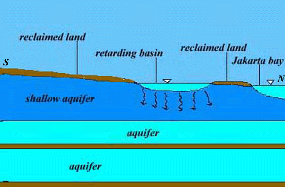
Fig. 3. Artificial lakes act as retarding basin in reclaimed land.
- Creating the groundwater extraction barrier, by means of a series of wells drilled parallel to the coastal line as long as 32 km. Those wells will continuously extract brackish groundwater from the aquifer, such that a zone of groundwater depression occurred which prevents sea water flows toward inland, and to maintain the stability of hydrostatic balance between salt and fresh water. The pumped water discharging back to the sea (Fig. 4).
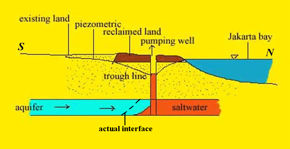
Fig. 4. Effect of pumping to saline-fresh water interface
Result of simulation using MODFLOW software shows that if groundwater is pumped out with total discharge of 4.67 million m3 year-1 from series of well parallel to shore line, then cone of depression with the deepest of 4 m below sea level occurred and act as extraction barrier to prevent salt water moving to inland (Fig. 5).
- Development of monitoring stations for land subsidence comprise of bench mark, monitoring wells for all aquifer systems, pore water pressure meter, and ekstensometer. Those proposed stations are located on Cengkareng, Pasar Ikan and Sunter area.
5. Concluding Remarks
In conclusion the water supply for all utilities in the reclamation land covering 2700 Ha must be provided from the resources other than groundwater. Such that the study to get the ultimate goal should be done comprehensively. How much water demands on the future reclamation land, and which surface water will provide most benefits. Referring to the C-5 scenario proposed by JWRMS, 1994, the water demands may probably be provided from Tarum Barat Channel (4.9 m3 sec-1). Channel 2 (31.2 m3 sec-1) is developed to distribute water from Jatiluhur Reservoir, and Serpong Channel (6 m3 sec-1), at the time where the total water demands in Jakarta being 42.1 m3/second in 2025.
Meanwhile the impact of land reclamation on the groundwater should be studied, whether any impact on the drainage pattern, availability and quality of groundwater in the whole Jakarta Basin.
Those efforts should be coincided with the increase of PAM Jaya roles. The progressions which have been reached to increase the service accessibility of PAM Jaya is still far from being proposed. Due to the groundwater resources as a raw materials for the water supply in the reclamation land can not be relied, such that management development for PAM Jaya is being important to be able in providing water supply for the reclamation land.
Programs being proposed by Kirmanto, 1995, through the co-operation with the private company, probably can be adopted to empower the performance of PAM Jaya to provide water in the reclamation land.
6. Acknowledgement
The authors wish to thank to the organizing committee for the invitation, hence, made this paper is presented in this workshop, possible.
Reference :
1. Anonymous, 1994, Jabotabek Water Resources Management Study, Ministry of Public Works, Jakarta.
2. Kirmanto, D., 1995, Peningkatan Pelayanan Air Minum di Jabotabek, Lokakarya Hasil Studi JWRMS, Departemen Pekerjaan Umum, Jakarta.
3. Sarmili L., Kusnida D., Faturochman A., dan Pindratno M.H., 1996. Sungai Purba Bawah Laut dalam Kaitannya dengan Rencana Pembangunan Reklamasi Pantai di Teluk Jakarta, Proseding, volume I PIT XXV IAGI, Ikatan Ahli Geologi Indonesia (IAGI), Bandung.
4. Schmidt G. and Tirtomihardjo H., 1986, Jakarta Groundwater Study, Ground-water Modelling, Working Paper (HAG) 116a, Directorate of Environmental Geology, Bandung - Federal Institute of Geosciences and Natural Resources, Hannover.
5. Tirtomihardjo H., Wawan S., Wishnu W., dan Boetje R.D. (+ ), 1994, Konservasi Airtanah di Wilayah DKI Jakarta - Tangerang - Bekasi, Direktorat Geologi Tata Lingkungan, Bandung (laporan tidak diterbitkan).