
This-200-year-old municipality of 2600 is dotted with maple, oak and birch trees between large farms, is located 80 kilometers southwest of Montreal, near the US boarder.
This-200-year-old municipality of 2600 is dotted with maple, oak and birch trees between large farms, is located 80 kilometers southwest of Montreal, near the US boarder.
1791: The Canada Act instituted the English plan of counties and townships.
Two Hundred years ago, the entire Chateauguay Valley, waas heavily forested. The Seigniory of Beauharnois on April 1729, when King Louis XV granted property to the Marquis de Beauharnois, then governor of New France, and his Brother. The seigniory was 18 miles square. Its eastern boundry was the Seigniory de Chateauguay; to the north the St.Lawrence River, and the western boundry lay just east, of what is now Dewittvile and Rockburn. The land lying west and south of the seigniory was called "waste land" and was not open for settlement. The Quebec-American border was undefined. Both sides of the border were under English rule. Hinchinbrooke was part of what was called the "waste lands".
After the Americans gained their independance in 1776, the location of the border was negotiated. The British needed to provide the British soldiers who had fought in the American Revolution, so it was decided to survey the "waste lands" and devide them into townships. In 1792 when the province moved from military rule to civilian government and the land was devided into 21 counties and Huntington County was established.
May, 1792: Quebec formed into 21 counties, the district lying west of Richelieu became a large county which took in seignieries. The townships/subdivisions were then named for areas in Old Huntingdon, such as Hemingford, Godmanchester, Hinchingbrook. This land was intended to be divided among the veterans of the American war, especially large parts of Godmanchester and Hinchinbrook (Sellers goes on to explain the variant spelling of some of these names, i.e. Hemingford becoming Hemmingford, Hinchingbrook becoming Hinchinbrook).
In 1793, W.Walker was sent to begin the survey of Hinchinbrooke. It was followed by Henry Holland the same season. They did not complete the task, but the of Hinchingbrook were established as the Western Border of the Seigniory of Beauharnois on the east, The American border on the south, the Trout River on the west and the Chateauguay River to the north.(Note: the present Township of ELGIN was part of Hinchinbrooke until 1855.) The Township of Hinchingbrooke was created in 1799, but it wasn't until 1801 that J. Rankin finished the survey work.
It appears that there were few, if any settlers in Hinchinbrooke before 1800. By 1809-10 there are reporst of a few American squatters crossing the border and erecting shanties on the upper section of the Chateauguay River. There was a larger settlement of mostly American squatters along the river at Ormstown.
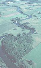
Aerial photo: The Chateauguay River winds its way northward through fertile farmland near Huntingdon, Qu�bec.
HINCHENBROOKE TOWN HALL
1056 Brook Road
This modern brick building sits on the site of Hinchinbrooke's original town hall, which was erected in 1864, and destroyed by fire in December 1988. The present building was erected in 1989.
The first meeting of the Hinchinbrooke council was held on July 13, 1855 when it was resolved "that the future meetings of this council be held in the house of Mrs.Alexander at Herdman's Corners, and that she be allowed the sum of Three Pounds currency, for one year from this date, for the use thereof, she consenting to the said agreement.

