| Perry Township's Geological Composition | |||||||||||||||||||
![]() |
|||||||||||||||||||
| A geologic section was taken at Little Salt Creek on the land of F. Dunn, in 1852. The location of this site is marked on this map. The results of the geologic section are listed below, as well as the implications of these results. | |||||||||||||||||||
| Sonora is in purple 
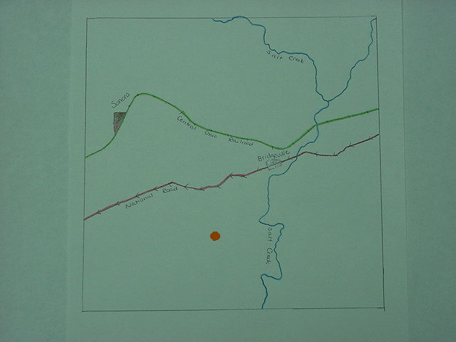
Bridgeville is in silver The National Road is in red. The Central Ohio Railroad is in green. Salt Creek is in blue. The brown dot is F. Dunn's property. Click on the map for a larger picture! |
|||||||||||||||||||
| Type of Stone Depth of Stone 1 Laminated Sandstone 20'0" 2 Shale 6'0" 3 Coal Blossom, Alexander Seam less than 1" 4 Shale 5'0" 5 Limonite Ore 0'5" 6 Shale 1'0" 7 Limestone 1'0" 8 Shale 5'0" 9 Clay and Ore 2'6" 10 Shale 2'0" 11 Coal 0'2" 12 Clay 2'0" 13 Laminated Sandstone, with Compact Sandstone 50'0" 14 Cannel Coal 0'8" 15 Coal 0'6" 16 Clay 1'6" 17 Shale 20'0" 18 Coal 2'0" 19 Shale 3'0" 20 Sandy Limestone and Siderite Ore 1'6" 21 Laminated Sandstone 10'0" |
|||||||||||||||||||
| Laminated sandstone is favorable for producing a variety of crops. The soil is rich and crops usually have high yields. The coal seams in Perry Township are small. The Alexander coal seam is a local seam and does not contain a significant amount of coal in Perry Township. The other coal seams (#11, #15, and #18) do not contain significant amounts of coal in Perry Township, either, although some mining has taken place in the past in Perry Township. | |||||||||||||||||||
| Sources Used: History of Muskingum County Ohio. J. F. Everhart and Company, 1882. Les Morrison, interview by author, 22 September 2001. For a complete list of sources used for this website, please click here. |
|||||||||||||||||||
![]() |
|||||||||||||||||||