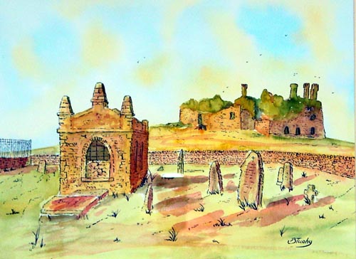
PEOPLE'S ART EXHIBITION - 26/27 November 2004 Church of Ireland Parish Centre, Main St., Lucan, Co. Dublin. (beside Lucan 2000)Brian Tuohy,Artist
Carbury Castle is located east of the Bog of Allen in County Kildare.It sits high on top of a hill just beyond the present day Church and is in the village of Carbury.I have seen it spelled different ways,including "Carbery and Carberry",but the village sign and the present day church both read "Carbury". "The Motte was probably built by Meiler Fitzhenry who was granted the area by Strongbow.The castle was acquired in the 14th century by the Berminghams." (info courtesy cloughmore.bravepages.com).The older parts of the castle were most likely built by them.In the 15th century,the castle was granted to the native Irish .
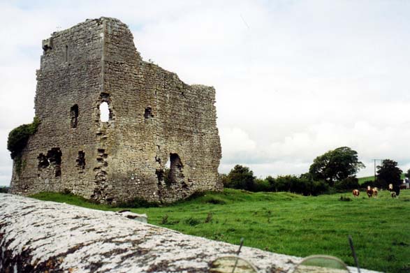
Carrickoris Castle at Edenderry
Photo kindly provided by John Bermingham
In 1562 Queen Elizabeth granted to Henry Colley the manor and the castle of Edenderry,also Drumcooley and some other land in Offaly.Along with these,he was also granted Castle Carbury and the recories of Carbury and Ballynorchar.In 1572, a commission was issued to Henry who was the seneschal of King's County,which authourised him to pursue rebels into the Kings' County.(The MacDonalds and O'Connors,etc.)
When he died in 1581,he left Edenderry to his eldest son and the castle at Carbury to his second son who was called William.It seems the castle was abandoned in the 1700s.
"It must be stated that Carbury Castle is a recorded monument and as such has legal protection under the National Monuments Acts, 1930-1994."
Croghan Hill when translated means a round or piled up hill. It is 769 feet above sea level and 460 above the land. Millions of years ago it was a volcano.
St. Patrick and St. Brigid were on the hill. Bishop MacCaille built a church where the old graveyard is now. St. Patrick's well is on the hill and the water in the well is blessed and is resorted to for cures.
Standing on the top of the hill you can see all of Offaly and its boundaries. The Slieve Blooms, the hills of Laois, the Hill of Allen, the Wicklow Mountains and on a clear day the Mountains of Mourne can be seen. This is why the hill was used as a main point when the Ordnance Survey maps of Ireland were made. The concrete post erected by them is still on top of the hill. The Annals of the Four Masters is an early written Irish history. Croghan is mentioned in the Annals of Ulster. In 468 A.D. there was a boxing match there and the death of MacCaille is recorded in 489 A.D.
Croghan Hill was the place where the chiefs of the O' Connor Faly were crowned. In the old Irish way they would have climbed to the top of the hill to survey all their lands. Their castle now in ruins is at the foot of the hill in Old Croghan.
Croghan Hill is historical and can be seen for miles in Leinster. The ancient name for the hill was Cruachan Bri Eile. This means the heap of the slope of Eile. Eile was the daughter of Eochy Feileach who ruled about 100 B.C. She was the sister of Queen Maeve of Connacht. There is a moat and cairn at the top of the hill. Local people say that Eile is interred inside with her chariot.
The hill is 769 feet high and has a clear view over most of Leinster. It is an extinct volcano which erupted 325 million years ago. This was at the end of the carboniferous period and Ireland looked like a coastal swamp.St. Patrick and St. Brigid were both on the hill. St. Patrick's Well is in Gleann Mor, Glenmore, the Big Glen. Brigid received her veil from MacCaille on the hill.The O' Connors were the chiefs of Croghan until the Plantation of Offaly. In 1563 Queen Elizabeth gave the land to Robert Colley. He was the son of the surveyor Walter Colley and related to Henry Colley of Edenderry Castle. This poem from 1380 shows the importance of the O' Connors long before the plantation.
Lord of Ui Failghe, land of cattle
It is not unknown to poets,
Is O' Connor hero of the plain,
Of the green smooth hill of Croghan.
In 1551 Croghan Hill and the surrounding lands were leased to Nicholas Burrell.The same land was given to Robert Cowley in 1563.This Cowley (or Colley) was a son of Walter the surveyor and a brother or nephew (25) of Captain Henry Cowley who was granted lands in the Edenderry area.Robert was killed in an attack on Phillipstown Fort.Thomasin Colley married Thomas Moore.In 1574 Thomas Moore was leased the Croghan lands for 21 but in 1577 the lands were granted to him.To hold forever,by the service of a twentieth part of a knight's fee.Rent �9.9s.6d after maintaining 5 horsemen.Other conditions relate to the keeping of English dress and custom.It was expected of all planters that they would provide military aid,till the land,and pay rent.About the same time Edward Moore,Thomas'elder brother was made Constable of Philipstown.He was directed to attack all the nations of the O'Connors and their followers who may be rebels; and those who support them.' Croghan castle was attecked by the Irish in 1599 (during the 9 years war) .It seems that Thomas was killed as John succeeded in this year.Hemade several additions to his already large estate,758 acres at Croghan.His most important acquistion was a gant from James in 1622,of 1147 acres of Tullamore.He married Dorothy,Loftus Lord Chancellor and archbishop of Dublin John died in April 1633 and was succedeed by his eldest son Thomas.He left two other sons who died unmarried and 6 daughters three of whom married locally.Thomasine to John Wakely of Ballyburley;Jane to Anthony O'Dempsey.At the time of the 1659 'Census'John,Thomas' son was lord of Croghan.
Today there are 5 houses and 17 people on the hill.
By; Martin Hannon and taken from the following site:
Croghan National School