To next page
Abd-el-Mo'al (15th?) Persian geographer
----------------------------------------------
Taken from: Herbelot; Bibliotheque orientale: ou Dictionnaire universel contenant tout ce qui fait...
Autour de La Geographie Orientale... Et Au-del: En L'Honneur de J. Thiry by Laurence Denooz
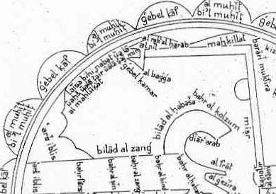
Abd el Moal, translator into Persian of Massahat al ardh by Abdal al Gionder. It has been impossible to identify the authors or the book.
Abdalmaal gives as borders for Ethiopia; in the south Zanguebar, in the east the Red Sea; North; the desert that is between the Red Sea, Nubia, and upper Thebaide; and west the desert of Bagiah or Beggiah
Macdoscho: City situated between Ethiopia and Zanzuebar close to the mouth of a river that starts at the feet of the mountains of the moon just like the Nile. This stream rises in the summer, just like the Nile of Egypt and the one of the Sudan, so it is like a third Nile that goes towards the east through the land of Berberah and ends up in the sea of Oman. The city of Macdofcho is before reaching the equator and inhabited by Muslims who came to live there during the days of the caliphs of Egypt.
Bais: Town in the country of the Zenge. Situated on the shore, between the towns of Sofala and Mambafa and is one of the most densely populated and most business oriented of that part.
(the slaves from Berbera) are more liked then those of Nubie, Ethiopia or Senega, because they are more reddish, while the others are more towards the yellow.
About Sofala: the people of that town are Muslims, they have no horses, but they use cattle instead, with which they even make war.