To next page
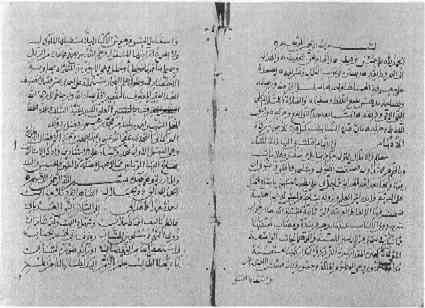
Left is the first page of the poem of Ibn Madjid called Hawiya from one of the several existing manuscripts
------------------------------------------------------------------------
f.88v-117r (of the Ms 2292 of Paris that contains only his writings)
Taken from : Ibrahim Khoury : La Hawiya in Bulletin d'etudes orientales 1971
Francois vire/Jean-Claude Hebert : Madagascar, Comores et Mascareignes
a travers la Hawiya d'Ibn Magis in Omaly sy anio
H. Grosset-Grange: la cote Africaine dans les routiers nautiques Arabes au
moment des grandes decouvertes. Azania 1978
I nowhere was able to find the complete text; this is a collection of the parts I found; the complete text will have way more information in it.
Tome 1 p100 V l.18 : the passage of the Franks at Madagascar, East Africa and India was since long time.
Chapter V: The indications of the directions of the littoral of Arabie, Hedjaz, Siam, the Gulf of Berbery, Somalia, of Mrima, of Zang, the islands of Qumr, the end of the Sudan, of Kanem, after measurements and exact written documents.
Chap V section 43 verses 101-138
Al-Qomr starts, in the north, with Great Bear at eleven fingers high, this is not idle talk;
I hear, brave one at Ras al-milh (salt cape) as well known with the Arab as Persian (sailors).
Some have said that this cape has 12 fingers; but in setting it is really the Big Bear at 11 fingers.
Between the island and (the coast) in front there are 56 zam without haggling.
And Angaziga (Grande Comore) between Madagascar and the Swahili coast is the one of the islands that is most known, remember what I say.
There is also Dumuni (Anjouan) and also Mulali (Moheli) with Big Bear at eleven fingers, without mistake.
One also finds, Muwutu (Mayotte) at Big Bear at ten fingers and a half, here you have some of the most remarkable islands. Up to you to remember what I said.
Besides these islands a heap of others mark out the coast (of Madagascar?), some have a name, and the others don't.
The most southern Cape of Madagascar, is only known to the one who revealed the gospel
And we did not gather on that issue nor sure figures, nor fingers in height, nor any mentions.
There is however, at its extreme North end with its harbors, the residence of the Sultan, and its islands,
All commentaries will be given with the names of the harbors in an other chapter and with all precision.
The route to Madagascar is: course to the west (the rhumb of ) of Sirius and there, the sea is hard to handle.
During a recent talk, and with the exceptional interest I have, with the rare (guides) who can talk about it from experience,
I learned that the extreme south of Madagascar is at Big Bear at one finger high and that to get there the route is: course to the south-west at (the rhumb of) Canope.
Some among them say that, all the way, the course to keep is (to the west) on (the rumb of) Sirius, this is what appears, farseeing friend.
The name of al-Qumr is taken from Qamiran son of Sem son of Noah, or second father.
In its big extent, Madagascar knows islands (in the east) in the extension of al-Fal (Laccadive + Maldives) locatable because of land-marks,
But also, surrounded by high seas and breaking waves, compared to the big island they are to the south,
Towards its south and at 12 zam there are big islands (This may be an allusion to the Mascarene islands) as high as the heaven; (Reunion island with a 3069 meters high peak) we do not know how high is the Big Bear there; we do not know to go to that wild uninhabited place (the Mascarene islands were uninhabited till 1646) what road to take in the sea, nor the distance,
In any case, we will inform you (about them) (the chapter on) the places of departure, then (the one on) the distances that they are separated, you who understands easily.
The merchants (and navigators) of Qumr know the coasts (of the high islands) themselves very well;
They bring from there, brother, ambergris, and that since ancient times.
Certain navigators have declared that (the coasts of) Madagascar and (the land of) Zandj are parallel and don't separate further one from the other as long as the Big Bear is still visible.
None of those who have been taken there made sure that you absolutely make the wrong course if you always keep south between the two coasts.
On the other hand it is a channel with dangerous places, with very violent currents.
As Allah decides that a sailing boat reaches (the extreme south) in the ocean (Uqanus), with great risk for live and belongings,
The one mislaid has no other place to go then the coasts of al-Kanim, to the south of the Sudan and that know it well.
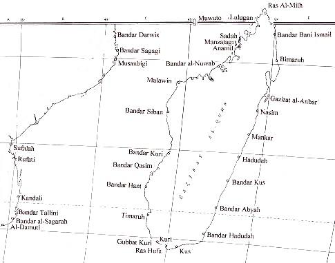
Navigator, it has also been said that the extreme south of Madagascar, where Big Bear is at one finger height, there is the harbor of Kouri (Bandar-Kouri), know this also!
The extreme north of Madagascar, there where is Lulugan (=Langany; Lulangane) is with all evidence, at Big Bear, 10 fingers height,
In a bay that will be a safe place, because oriented to the south it stretches between two headlands, and remember well that I said.
I more in detail say that the Cape of Salt is on Big Bear 11 fingers high and that Manzalagi (= Old Masselage) comes up at Big Bear 10 fingers, remember this.
Navigator; they told us that the distance (east-west) of Madagascar is 20 zam, it is that at least that the wise ones say.
Know also that all around Madagascar there are only reefs and islands
With Big Bear at seven fingers height and un-deep water, take the course tack to port side at (the rumb of) Arcturus and go till Big Bear arrives at 8 fingers for the one who observes from the ship.
See here how Madagascar is shown; as to its heights in fingers I will tell in the 7th chapter.
Chapter VII verses 135 to 144: (strangely enough no information is given for the traffic between Madagascar and the African mainland; only what courses to follow between 7 main harbors in Madagascar and the islands of Tiri-Raga.)
(Paragraph with title:)The harbors from which to leave at the coast of Madagascar
When the coast of (east) appear of Madagascar, your intension is to get through to the islands (of the east)
Put the course to Tiri-Raga (=one of the Mascarene) following (the rumb of) Achernar, starting from a latitude equal to that of Sa'da; this is how my informer told me.
Then the harbor Bani-Ismail, go my friend, to the east following ( the rumb of ) Canope
From Mankar, take the course east on (the rumb of) Achernar and Tiri-Raga appears surely at your horizon.
From Haduda, with course east on (the rumb of) Scorpion you will get there also, you who are broken from the routine.
But your route will be on (the rumb of) Altair (=strait east) if you sail from the accesses to the harbor of Kus (Bandar Kus), don't stop from learning.
You reach, brother the island Tira-Riga from Bandar Abya (or Abaya) that is certain,
When keeping, friend, course to the easr on (the rumb of) Arcturus. As well you reach from Kouri, when taking course to the east on (the rumb of) Capella.
See here what are all the routes (on the east) of Madagascar; it is up to you to understand well my verses.
If it were not, my brother, because of differences in the reports of my informers, we would have listed the double amount of noteworthy places.
(Paragraph with title:) The harbors from which to leave at the coast of Berbera
(I do not possess this text.)
Chapter VIII
Knowledge of the distances between the coast of Arabia and the ones of India, from the place where the height of the pole star 5 fingers is, to the place where it is 12 fingers. Enumerating the distances in zam between the harbors situated on 4 principal latitudes comparing with what has been written about it; and starting from those distances all other distances in the sea can be calculated.
Tome1 p110 R l.3 of the Ms 2292
From Pemba to Karmadnua it is 150 zam and even more according to another estimation; de Karmadnua to Sund of java there are 130 zam making the total between Java and Pemba 300 minus 20.
Tome1 p111 V l.2 of the Ms 2292
Java and Pemba also called Aithriqari and Karm Danua and the harbor of Java are at 1 finger of the pole star.
Madjid lets us know that he was unable to obtain the exact distances for China and Madagascar. (This in a list of distances in zam between different harbors)
Chapter IX: The determination of the height of the Polar star, the two Guards, and the Wagon at the moment of the culmination of ? of the Lion, for all the known capes situated in the ocean and on the northern site; that is to say the Indian sea, the one of Siam, of Arabia, and of the Sawahil
(In a table of altitudes of the polar star in fingers above the horizon decreasing from 11 to 1 finger)
4 fingers; Gardafun (and several places in Asia).
(In a table of altitudes of the two Guards in fingers above the horizon decreasing from 7 to 1 finger)
5 fingers; Barawa (and many others in Asia)
3 fingers; Kitawa etc..
2 fingers; Munbasa, Zarrin (Seychelles lit. meaning sisters)
(In a table of altitudes of the wagon in fingers above the horizon decreasing from 12 to 1 finger. Here I give the whole table as there are many places here that interest us)
Chapter IX section 69 verses 50-79( Big Bear = the Wagon)
12 fingers: Surabaya, the island Fali, Java, Manfiyya
11 fingers: al-Harba, Huriyya, cap al-Milh, Faydin, Sasi-Timur, Kilwa, Angaziga,(=Grand Comore); Hanzuwani,(=Anjouan); Mulali (=Moheli), Dumuni.
10 fingers: the islands Timur, al-Qumr, the harbor Bani Isma'il, Lulugan (=Langani), al-Ahwar, Sofala
9 fingers: Bimaru (=Vohemar), Anamil, the harbor Darwis, Manzilagi (=old Masselage), Sa'da.
8 fingers: The island Anbar, the harbor Sagagi, Musanbigi, the harbor al-Nuwab.
7 fingers: Nasim, Malawin
6 fingers: Sofala, the harbor Si'ban, Mankar.
5 fingers: the harbor Haduda, the harbor Kuri, Rufati.
4 fingers: the harbor Kus, the harbor Qasim, Kandali.
3 fingers: the harbor Hant, the harbor Tallini, Abya, Tiri-Raga.
2 fingers: Haduda, Timaruh.
1 finger: the harbor Kus, the bay of Kuri, the harbor al-Sagara
fol, 112a; section 9
.... The harbor of al-Shadjara (Lorenzo Marques?)which is well known lies one isba from the na'sh. The learned give this as the position of this port. There are no others having a name..... And there is nothing south of these lands, for it is there the land of Zeng ends and there is the strait (that leads) to the land of the west and of the Franks. There is nothing to the south (of Africa) except reefs and darkness which the creator (alone) knows. Some say that there are islands and that the extreme end of the coast is 5 isba (18deg 21 min S) - O thou, the best informed. But the stories of the authorities do not agree. We ask Allah to pardon our errors.
The pictures shown here and the text in red do not belong to the manuscript of Ibn Majid. (Ibn Majid's mss is the earliest Arabic book of Madagascar). They belong to Theodore de Bry of Frankfurt who made them 1598-1603. And they represent some of the earliest drawings of Madagascar from Europe. They are added here as illustration only.
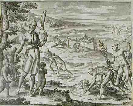
The country-folk of the island of Madagascar often carry about with them three or four long, sharp arrows, called Affagayas or Loffo. They used them as weapons and were so accurate that they could hit a coin six times in succession, just as effectively as we could with a musket. They have, neither religion nor law. Once, while three Dutchmen were exploring their land they were suddenly surprised by an attack from the natives who continued throwing stones at them until they surrendered. The Dutchmen were then robbed of all their possessions, including their clothing, and had no choice but to run away naked.
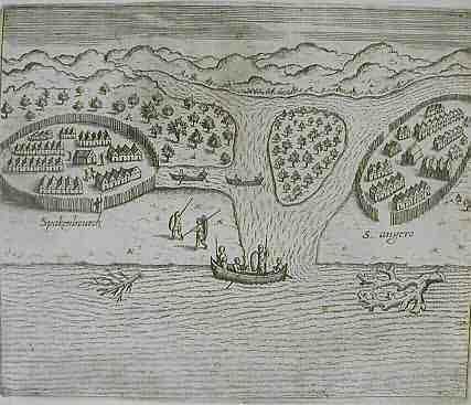
On this island we came across two villages, which we named Spakenburg and St. Angela. Both villages were enclosed by poles, stuck in the ground with only two entrances, one to the land, the other to the water. Within these enclosures were about two-hundred dwellings supported on wooden poles to prevent vermin from getting inside. In the middle of these dwellings is a large house for the chieftain, where a guard is permanently on duty. At Spackenburg we traded with the natives and met the chieftain, who was drunk and who invited us to sample their brew, which was made of rice and honey and served in an ox's horn. There was also an inn in the village where our shipmates sat drinking and making merry with the natives.
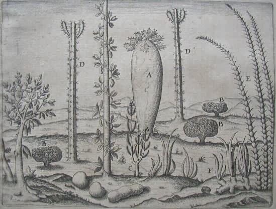
A denotes a tree with only a few twigs on the top. From this tree canoes and boats are made. B is a bush that the Dutch frequently encountered and called leafless because it hardly has any leaves and produces a scaly seed. The young tender shoots are used in the treatment of scurvy. C is a plant that the Portuguese call camarinnas which has a brownish leaf. Its fruit is a small pearl-like berry that tastes slightly sour. D is a tall, thorny growth, as wide as a fist and as long as a spear. It has a black skin full of prickles instead of leaves. E is a sugar cane that grows on the island of S. Maria. F is the plant we call ginger.
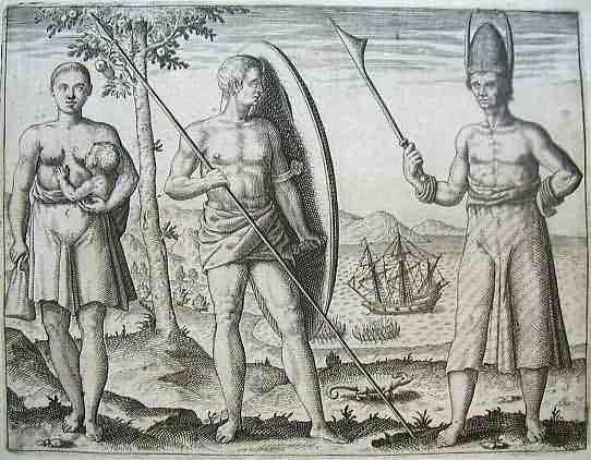
While we were moored off the island of Santa Maria, a galliot arrived with the king of the island aboard. His name was Philo and he had in his hand a strange rod, as shown in this picture. His garment was a kind of striped cotton shirt and on his head he wore a pointed helmet, rather like a bishop's mitre. It was beautifully decorated and on either side were horns, half a yard long, with little pointed tassels. He, and his entourage of twenty-five aristocrats, looked at our ship with great admiration. In this illustration is also shown a native from the cove of the island Tangil, with his weapon and a great wooden shield, which had at the top a long slit cut out, through which he could see and feel safe. Their lances are two fathoms in length and have a wide, iron spearhead. The women crop their hair and wear it short as the men do and they suckle their children as shown here.
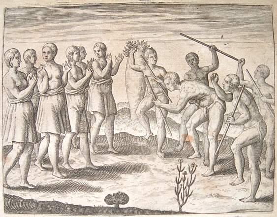
While we Dutchmen were in Madagascar we observed the following dance, performed by the poorest people. The men went naked, except for a small mat, woven from tree-bark. First, about twenty men assemble with their weapons in their hands, followed by the women. After they had all gathered, the men stepped back, leapt into the air, swinging their feet out behind them like angry horses, so that whomsoever stood behind them would be in great danger of being kicked. Meanwhile, the women, standing opposite, acted as their musicians by clapping their hands, singing sweetly and stamping their feet in rhythm. It was a very strange performance to observe.