To next page
Ibn Majid: Other Poems
Taken from : Ibrahim Khoury in Bulletin d'etudes orientales 1985-86/87-88
H. Grosset-Grange: la cote Africaine dans les routiers nautiques Arabes au
moment des grandes decouvertes. Azania 1978
I nowhere found the complete text; this is just a collection of extracts as found. The original text will have way more information available.
Al-Urguza as-Sabiyya (the poem of the 7 nautical sciences.)
Ibrahim Khoury in Bulletin d'etudes orientales 1985-86/87-88
Sailing between the western coast of the Deccan and the Hedjaz or the harbor of Gudda
The trip is made in four steps. The 100st day of Nirouz is the best day to leave Malabar.
Malabar-Kalpeni to the Laccadive
First one navigates for a distance of 12 zam to reach the island of Kalpeni. Ibn Majid describes it as well as several other islands.
Kalpeni-Cape Guardafui
One then goes through the sea of Oman to arrive in front of cape Gardafui where the pole star is seen at 4 fingers.
Cape Gardafui-Aden
From Cape Gardafui there are two routes to choose from to go to Aden: or one goes to cape Filuk at 2 zam, then Mayt at 12 zam, and then you have Aden at 20 zam on the other side of the sea of Berbera. One can also go strait from Filuk to Aden for 30 zam.
Aden-Gudda: the last part.
Mawasin as-Safar (the calendar for Sea voyages.)
Taken from: Ibrahim Khoury in Bulletin d'etudes orientales 1985-86/87-88
This poem is only 19 verses,
In the first paragraph there are no travels to or from east Africa.
Then:11 verses talk about the travels between the Indian ocean ports after the appearance of Spica this is on 326 day of Nirouz or 5 October.
The ships can leave Aden for the opposite coast of Somalia or for Sihr; they leave Hormuz for India and Yemen; out of India they go to many directions; They leave Madagascar to go to the land of Zang; and from Zang they go to Yemen or Hormuz
The 3 last verses are about the travels after the appearance of Acrux on the 117 day of Nirouz or 10 March.
The sailors of al-Ahqaf and the ones from Zafari leave to the land of Zang; the ones of Java leave for Malacca and Sanf
Qismatul-Gumma ala angumi Banati nas; (Dividing the seas according to the Big Wagon =Big Bear)
Taken from: Ibrahim Khoury in Bulletin d'etudes orientales 1985-86/87-88
Latitude of Pole star is 4 fingers:
At Gardafun; Canope and Fomalhaut are 4+ fingers
At Al-Qumr; ? of the Big Bear and ? Pegassus are 4 fingers
At Hafun; Canope and Rigil Kent are 51/2+ fingers.
Al-Muarriba (About sailing in the Gulf of Berbera)
Taken from: Ibrahim Khoury in Bulletin d'etudes orientales 1985-86/87-88
Navigation in the eastern part of the Gulf.
Two routes leave from Ras Hafun; the first for Socotra, Samha, Darza, and Abd al-Kuri; the other for the Red Mountains (Cape Gardafui) and for cape Filuk.
Two other routes are described between the Red Mountains and the islands of Abd al-Kuri and Sager.
Two lines connect Ras Filuk with Dafari and Dar Zayna on the coast of Arabia, a third connects with Hagra on the Somali coast.
Very last Poem in this volume 1
Taken from: H. Grosset-Grange: la cote Africaine dans les routiers nautiques Arabes au
moment des grandes decouvertes. Azania 1978
Tome1 p181 R l.13 and following lines
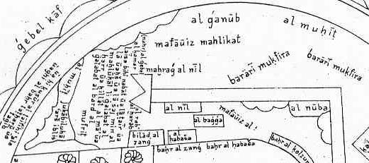
The meridian of Hormuz passes by the Cape of Salt; the one of Hadd at the Zarrin (Seychelles) and at Qumr at 12 fingers, then continues into the unknown; the one of Masira reaches Qumr to the west of the one of the one of hadd at 4 zam; the one of Madraki reaches Qumr to the west of the one of Masira at 8 zam; the one of Kuria passes Socotra with Jah at 5 fingers then reaches the western Cape of Qumr to the west of Hadd at 20 zam; the one of Dofar passes west of Socotra at 8 zam, and east of Fartak and Gardafui at 4 zam then at Qumr at 10 fingers; the one of Fartak and Gardafui reaches Qumr at 91/2 fingers. (Gosset-Grange uses the figures here given to calculate where Qumr was situated in the ocean; see his map I added to Majid's Sufaliya)
Dariba al-dara'ib (nature of proportions)
Taken from Roshdi: Encyclopedia of the History of Arabic Science
in which he associates distances with variations in the altitudes of stars.
The estimated distance of the first rhumb is heavy...... One does not count it from Hadmati to your Muluk (from 2deg35min to 1 deg 50min North, in the Maldives) as one counts it from Bab (el Mandeb) to Zuqur, nor from Muruti to Brava