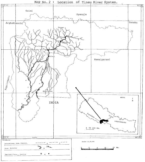
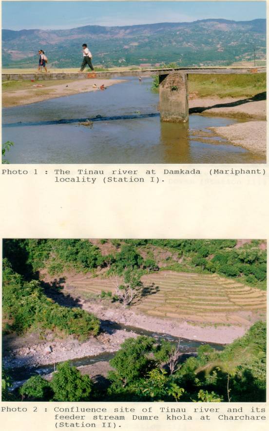
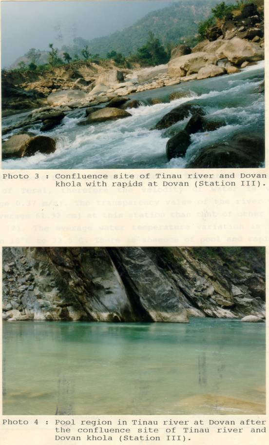
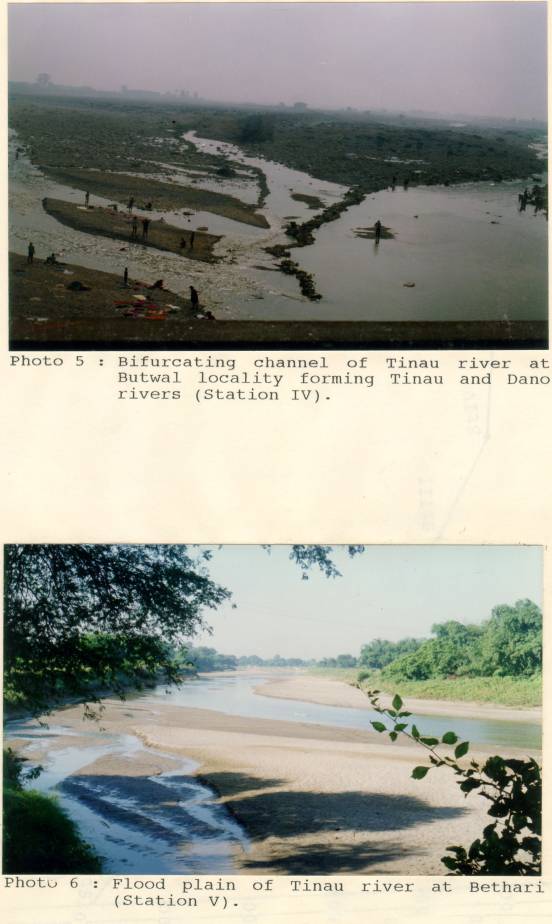
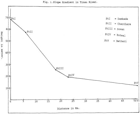
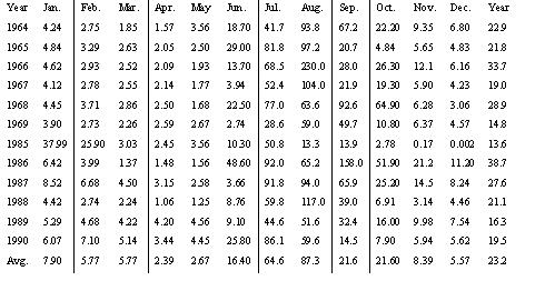
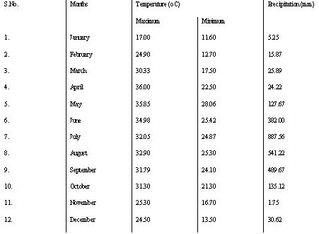
| 3. STUDY AREA The Tinau river, originating from the Mahabharat range of Palpa district about 20 km east of Tansen, is selected as the study area for the present study. It is separate from the three major river systems of Nepal, lying at an altitude of about 100 meter to 800 meter from the sea level. It flows to southern direction joining many feeder streams along its way through a valley called Mariphant. About five kilometre south of Mariphant it meets two feeder streams at Charchare, viz., Dumre and Suke. The Tinau River on its way towards south direction meets Sisne Khola and Jhumsa Khola at Jhumsa and after Jhumsa it is also called Jhumsa River. The Tinau River then flows towards west and meets the largest feeder stream Dovan Khola at Dovan (Map no. 2). Before entering the Terai region it meets another feeder stream called Chidiya Khola at Siddhababa temple. Tinau River bifurcates into two channels fro Butwal, one flows straight to south direction and enters into India crossing Bethari, while another channel flows to southwest direction and is then known as Dano River. Both of these rivers again meet each other in India. Tinau River makes a journey of about 95 kilometres in Nepal and passes to India but the present study covers 51 kilometres from Mariphant to Bethari which includes valley, Hill region as well as Terai region. It makes terraces of about 200 meters at some places in the Hill region. The main stream is narrow in the northern region due to the presence of hard and strong rocks on the bank which has comparatively more depth and looks like gully but on reaching the Terai region it gets elaborated width towards south direction. A number of villages are situated in the bank of the Tinau River including a town Butwal. Water resources in the Tinau River have been utilized for drinking, washing, bathing, hydroelectricity and irrigation purposes. 3.1 STUDY SITES Before starting regular sampling programme surveying techniques were followed up for the fixation of stations at the suitable places from the point of view that the samples taken might represent the average faunal composition of the Tinau River. For the present investigation five stations were selected taking into account the altitudinal variation, human settlements, confluences of other tributaries, dam sites etc. which are as follows from north to south direction. Station I : Damkada (Mariphant) Station II: Charchare Station III: Dovan Station IV: Butwal Station V: Bethari 3.1.1 Station I (Damkada) Station I was fixed at Damkada (Mariphant), Palpa district, with an altitude of 684 meter. This was the upper most station with less interference of human beings (Photo 1). The riverbed is composed of mud, sand, and gravels. This is a plain valley region where the average velocity of water is 0.54 m/s. the river water at this station remains clear throughout the year except monsoon during which this valley gets flooded. The water temperature varies in between 16.5oC and 29oC. 3.2.1 Station II (Charchare) Station II was fixed at Charchare about 5 km down from Damkada at the confluence point with Dumre Khola (Photo 2). The characteristics of the Tinau River at this station are pools and rapids. The riverbed is composed of sand, gravels, boulders and bedrocks. The water temperature varies from 16.5oC to 31oC at this station which lies at an altitude of 574 m. 3.1.3 Station III (Dovan) Station III was fixed at Dovan with an altitude of 250 m situated about 5 km north of Butwal. It was fixed at the confluence of mainstream to a feeder stream called Dovan, the largest tributary mixing to the Tinau River (Photo 3 and 4). Average width of the riverbed at this station is about 90 meter. Watercolour remains transparent and clear throughout the year except monsoon. The water temperature ranges between 17oC to 29oC. The river is broken into pools and rapids, which provides a good habitat for fishes. The riverbed consists of sand, gravels, pebbles, boulders and bedrocks. Some amount of mud and detritus are also present at the bank of the river. A dam has been built at this station to generate hydroelectric power. 3.1.4 Station IV (Butwal) Butwal is the head quarter of Lumbini zone and is situated at an altitude of 188 meter above the sea level. This place was chosen as station IV that is the junction of Hilly and Terai region. After entering into the Terai region the river expands widely (Photo 5). The velocity of water gradually starts decreasing from this place towards Bethari. The water is clear and more transparent throughout the year except monsoon. The water temperature variation at this station is 17oC to 26.5oC. Some pools and rapids are present at this station also and this station has good sheltering places for fishes. The riverbed consists of silt, sand, gravels, pebbles, boulders and bedrocks. From this place Tinau river is bifurcated in two channels, one towards straight south direction and another to the southwest direction which are called Tinau and Dano respectively. 3.1.5 Station V (Bethari) Bethari is situated about 5 kilometres west of Bhairahawa, the head quarter of Rupandehi district. It is situated at an altitude of 107 meter above the sea level (Photo 6). This station lies in the plain of Terai, therefore the velocity of water is very low (average 0.37 m/s). The transparency value of the river water is low (average 61.92 cm) at this station than that of other stations (Table 12). The average water temperature variation is found in between 18oC to 32.5oC. There is absence of pool and rapid zones. The riverbed consists of mud, silt, sand, clay and detritus. The altitude of each of the five stations is given in the Table 4. The slope gradient of the study area is shown in Figure1. Table 4: Altitude of Different Stations --------------------------------------------------------------------- Stations Locality Altitude (m) --------------------------------------------------------------------- I Damkada 684 II Charchare 574 III Dovan 250 IV Butwal 188 V Bethari 107 -------------------------------------------------------------------- 3.2 RIVER ECOLOGY The ecology of Tinau River has been studied in general as follows. The water of Tinau River is highly saturated with dissolved oxygen which varies from 8.92 mg/l to 5.68 mg/l. The pH value of this river water varies from 8.6 to 7.8. The water temperature of the Tinau River ranges between 16.5oC and 32.5oC. The transparency of the river water remains high throughout the year except monsoon. Total alkalinity of water in the Tinau River varies in between 54.054 mg/l to 12.012 mg/l. Similarly total hardness varies in between 204 mg/l and 54 mg/l and free carbon dioxide varies in between 13.99 mg/l and 3.99 mg/l. Thus, the conditions of water quality in the Tinau River such as higher concentration of DO, range of temperature variations, value of total hardness, slightly alkaline pH value etc. are favourable for many indigenous fish species. Using hydrological data recorded from 1964 through 1990, mean discharge for the high water season was 87.3 m3/s and mean discharge for the low water season was 2.39 m3/s. In the Tinau river the maximum flow of water was recorded in August (87.3 m3/s) and the minimum flow in April (2.39 m3/s) as shown in the table 5 (Department of hydrology and meteorology HMG/N). High flow in the Tinau River occurs during June to November and low flow in December to May, with little variation from year to year (Table 5). Table 5: Mean Monthly and Yearly Discharges in Tinau River (m3/sec) Source: Department of Hydrology and Meteorology, HMG/N. In the Tinau River, there is a hydroelectric dam at Dovan which provides a threat for the migratory fishes like Tor sps. and Psuedeutropius sps. The riverbed of Tinau River consists of gravels, pebbles, sand and bedrocks in the hilly area and mud, sand and detritus in the plain part of Terai and Mariphant. The climatological data recorded from 1982 through 1990 show the average maximum temperature record as 36oC in the month of April and minimum temperature as 11.6oC in January in Butwal locality. Similarly, the maximum precipitation was recorded 887.56 mm in July and minimum 1.75 mm in November in Butwal locality which was taken as mean from 1982 through 1990 (Table 6). Table 6: Average Monthly Temperature and Precipitation at Butwal Locality (1982/90). Source: Department of Hydrology and Meteorology, HMG/N. |
 |
 |
 |
 |
 |
 |
 |
| Home | Family | Curriculum | Thesis TU | Thesis NLH | Publications | Term Papers | Recent Paper | Proposal | Nepali Poems |
| You are here: Home>>>MSc Thesis TU>>>Study Area |