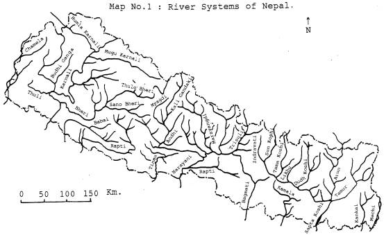
| 1. INTRODUCTION Nepal is a small country with amazing geographical regions, viz., low plain land, mid land and high land with snow cover. It is roughly rectangular and elongated in shape averaging about 885 km in length (east-west) and 193 km in width (north-south). The altitude ranges from 70 meter above sea level in the Terai region (south) to 8,848 meter at the peak of the world, Mount Everest (Sagarmatha) in the north. It is situated on the northern hemisphere in between 26o22� to 30o27� north latitude and 80o4� to 88o12� east longitude with the total area of 1,47,181 sq. km. The kingdom of Nepal is located in between two big countries, China in the north and India in the south. In between Nepal and Tibetan territory of China, the Himalayan Mountain acts as the frontier. In the east, Nepal is separated from India by the Siwalik range in the north and Mechi River in the south. In the south there is no natural boundary and the artificial pillars at an average distance of 10 yards (locally known as �Das Gaja Khamba�) have been erected to demarcate the boundary between Nepal and India (Amatya and Shrestha, 1967). 1.1 TOPOGRAPHY There are three distinct geographical regions in Nepal according to the altitudinal variation, viz., the Himalayan region, the Sub-Himalayan region and lower plain of Terai region. The Himalayan region contributes about 15 percent (22,077 sq. km.) of the total area of Nepal. This region lies above the altitudinal range of 16000 ft (4800 m) from the sea level (Amatya and Shrestha, 1967). This region is always covered with snow and no fishes are recorded from this region. The Sub-Himalayan region or mountainous region is located between the south of the Himalayas and the north of the Terai region with a chain of massive mountains running from west to east which constitutes about 68 percent of the total area of Nepal, lying in between 2000 ft (600 m) to 16000 ft (4800 m). This part consists of many basins, valleys and Duns among which Kathmandu valley and Pokhara valley (Schizothorax sps) and Buduna (Garra sps) are found. But in the lower parts in between 9000 ft (2700 m) and 2000 ft (600 m) of this part fishes like Sahar (Tor putitora), (Tor tor), (Barbus tor), Catla (Catla catla), Rohu (Labeo dero), Sidre (Puntius sps), Fageta (Barilius sps) and Kabhre (Glyptothorax sps) etc. are found (Mandal, 1995). The lower plain of Terai is a narrow belt of low land situated at an altitude above 70 meter from sea level to sub-Himalayan region which is the most important region from fishery point of view. The Terai region including inner Terai represents about 25 percent of the total area of Nepal. The important fishes found in this region are Rohu (Labeo rohita), Buhari (Wallago attu), Murrel (Channa gachua), (Channa marulius), Sidre (Puntius sophore), (Puntius sarana), Bam (Xenentodon cancila), and Mahaseer (Tor tor) etc. 1.2 CLIMATE Nepal is a country with extreme climatic contrasts. The climate of Nepal is greatly influenced by altitudinal variation as well as by the location in a sub-tropical latitude. Within a small compass, almost all the climatic zones of the earth are represented in Nepal such as tropical jungle in the Gangetic plain, artic desert wastes in the higher region and the arid zones of the Tibetan plateau (Panday, 1987). The vertical variation causes much more contrasts in the Nepalese meteorological variables, mostly temperature, moisture, winds and precipitation. Due to the altitudinal effect, the temperature distribution in Nepal is not uniform. As such, Lowlands like the Terai and inner Terai parts and midlands are warmer, and the Hilly and the Himalayan regions are cooler. The temperature rises from March to July while it decreases from October to January. The land structure, latitude, altitude, distance from the sea, winds, clouds and rainfalls are the factors that create differences in the climate. On the whole, Nepal has a monsoon climate which is dominating all the agro-cultural activities of the country. On the basis of temperature and condition of the precipitation, the climate of Nepal can be regionally divided into five belts (Panday, 1987). Sub-tropical climate lies up to 1200 meter which includes the lowlands (Terai, inner Terai and deep valleys in the middle mountain of Nepal). The temperature remains high in this lowland area in comparison to other parts of Nepal. The average annual temperature ranges in between 15-40oC in this region. The average annual precipitation is 2000 mm (1300 to 2600 mm) with a very little rain in the winter season. Warm-temperate climatic region includes the upper parts of Chure and Mahabharat regions (1200- 2100 m) which are mild and moderately hot. The temperature ranges in between 24-30oC in summer and winter falls less than 0oC. Average annual precipitation is 1250 mm which decreases in the northern side considerably. This region (Midland Nepal) provides pleasant climatic condition to the human habitation and favourable climate for cultivation. Cool-temperate region lies between 2100- 3300 meter in the higher parts of Mahabharat Lekh and lower parts of Himalayas. In the summer season the temperature is about 15- 20oC and winter falls less than 0oC cold. Rainfall in summer is about 1000 mm which decreases in the northern part. The Alpine climate is seen between 3300- 5000 meter in the north, down the snowline region and the Himalayan valleys. In most of the Alpine regions the temperature rises up to 10- 15oC in summer and fall 0oC in winter. About three-fourth of the year remains snowy, thus, the winter is too cold and long. Annual precipitation in this area is about 400 mm. Himalayan desert climate lies above 5000 meter where snow remains freezing above the snowline. This snow clad main Himalayan land has created rain shadow. Hence, the climate of this region is comparable to desert of the arid condition. Rainfall in this cold desert is nominal. In the summer season also, the temperature is very low and in the winter it falls more. Upper region gets snowfall and strong snowstorms round the year (Panday, 1987). 1.3 WATER RESOURCES The inland water resources totalling 745,000 ha consist of river systems, lakes, reservoirs, village ponds, wet lands and irrigated rice fields (Table 1). Various types of inland water resources existing in the country provide a great scope for the expansion of fisheries. These resources can be categorized as i) open inland waters of rivers, lakes and reservoirs, ii) closed water bodies, ponds and wet lands, and iii) seasonal irrigated rice fields. Table 1: Estimated Water Surface Area in Nepal. S.No. Resources Estimated Area (ha) Coverage Percentage Potential Area (ha) ---------------------------------------------------------------------------------------------------------------------------------------------------------------------- 1. Natural waters 401,500 53.8 a. Rivers 395,000 52.9 b. Lakes 5,000 0.7 c. Reservoirs 1,500 0.2 78,000 2. Village ponds 6,700 0.9 14,000 3. Wet lands 12,500 1.7 4. Irrigated rice fields 43.6 ------------------------------------------------------------------------------------------------------------------------------------------------------------------------ Total 745,000 100.0 92,000 ------------------------------------------------------------------------------------------------------------------------------------------------------------------------ Source: Fisheries Development Division, HMG, 1993 (cited in Pradhan and Pantha, 1995). 1.3.1 Natural Water Resources The natural water resources consist of rivers, lakes and reservoirs, comprising of approximately 54 percent of the total existing water area of Nepal. 1.3.1.1 Lakes There are several lakes in Nepal which are scattered all over the country. The estimated area of the lake is 5000 ha (0.7 %) of the total existing water areas of Nepal. The lakes can be categorized to 3 types on the basis of their origin, viz., I) Glacial, ii) Ox-bow and iii) Tectonic. There are 17 major glacial lakes in the northern Himalayan region which are located above 4000-meter altitude. In most cases, the tectonic lakes have drained out, and have been replaced by flat basins which occur in the Hill region. The Kathmandu valley, Banepa area, Panchkhal, Mariphant (Palpa),Dang and Surkhet valleys are the good examples of such basins. Ox-bow lakes are mainly confined to the southern part of the country (Terai and inner Terai). The presence of Ox-bow lakes indicates the shift of river course and there are more than two dozens of ox-bow lakes in Nepal (Sharma, 1977). 1.3.1.2 Reservoirs There are few reservoirs in Nepal with a total area of 1500 (0.2 %). These reservoirs are mainly constructed for hydroelectric power and irrigation. Among the existing reservoirs, the Indrasarobar reservoir, Kulekhani (1430 m) is a newly impounded reservoir for producing hydroelectric power by damming Kulekhani river in the mid hill region of Nepal. Other existing reservoirs are Jagadispur (Banganga, 125 ha), Trishuli (16 ha), Marsyangdi (62 ha), Panauti, Gandak, Sunkoshi, and Andhikhola, which are mainly constructed for irrigation and generating hydroelectric power. More than 33 small hydropower reservoirs are existing all over the country (Nepal Electric Authority, FY 1990/91, A year in review, August 1991, cited in Shrestha, 1992). Furthermore, growth in hydroelectric and irrigation projects will add more water surface area in future. Development of the Gandaki basin (45,000 ha), the Bagmati river system (9,000 ha), and the Karnali river system (24,000 ha) will add 78,000 ha of reservoirs on their completion (FDD, 1993 cited in Shrestha, 1992). About 4-5 percent of the irrigated areas in Terai are low lying, generally unsuitable for crops cultivation, and can suitably be developed into fishponds. Recently HMG/N has given priority to the construction of Kaligandaki �A� hydropower project (reservoir of 60 ha), which will be completed by 1997 (Shrestha, 1992). Collectively, these water bodies cover nearly 3 percent of Nepal�s land area. It is estimated that some 500,000 hectares of waters surface may be available to fish production, of which approximately 100,000 hectares would be lakes, reservoirs and village ponds (NARC, 1991/92 cited in Pradhan and Pantha, 1995). 1.3.1.3 Rivers Nepal has more than 6000 rivers and streams with total length of about 21000 km flowing from the north to the south. There are three major river systems in Nepal which drain out the country. Each river system has seven main tributaries, fed with numerous branches and are subsequently called i) the Sapta Koshi, in the east, ii) the Sapta Gandaki, in the centre and iii) the Sapta Karnali, in the west. Besides these, the Mahakali, the Kankai, the Kamala, the Mechi, the Rapti, the Babai and the Tinau are also equally important rivers (Map No. 1). All these river systems constitute about 53 percent of the total water area of Nepal (Table 1). All the tributaries of these river systems drain into the Ganges system in India. The combined run off through Nepalese rivers contributes 40 percent of the annual flow of the Ganges River and 71 percent of the dry season flow (Abbas, 1982 cited in Shrestha, 1992). Hydrologically the rivers of Nepal can be divided into i) purely rain fed rives and ii) snow plus rain fed. The rivers of shorter lengths are seasonal and dry up from time to time. But in snow fed rivers, the melting of the snow in the Himalayas balances to check the further flow. The rivers of Nepal loose their speed as they reach the southern plain or Terai region and deposit silt in the fertile flood plains. Some of the rivers in Nepal are used for irrigation. Up till now most of the Mahabharat rivers have been tapped such as the Kankai, the Kamala, the Bagmati and the Tinau (Shrestha, 1992). In the Tinau River, which originates from the Mahabharat range, the water level during winter falls to considerable amount but doesn�t dry up. It is, therefore, important from biodiversity standpoint. But the Tinau River is becoming polluted since few years due to landslides in hilly areas caused by deforestation (Gross soil loss 286950 ton/yr and soil loss rate 59.18 ton/ha/yr, DCSWM and DCSWMO, 1992), intensive use of fertilisers, pesticides and disposal of domestic wastages in the river. The biodiversities of the Tinau River, therefore, have been selected for the present study. |
 |
| Home | Family | Curriculum | Thesis TU | Thesis NLH | Publications | Term Papers | Recent Paper | Proposal | Nepali Poems |
| You are here: Home>>>MSc Thesis TU>>>Introduction |