Guest
Author:
August Hunt
August
Hunt, (1960), published his
first short stories in his high school
newspaper, THE WILDCAT WIRES. These were
followed by stories and poems in THE
PHOENIX literary magazine of Clark
Community College, where he received a
writing scholarship. Transferring to THE
EVERGREEN STATE COLLEGE in Olympia, WA,
he continued to publish pieces in local
publications and was awarded the Edith K.
Draham literary prize. A few years after
graduating in 1985 with a degree in
Celtic and Germanic Studies, he published
"The Road of the
Sun: Travels of the Zodiac Twins in Near
Eastern and European Myth".
Magazine contributions include a cover
article on the ancient Sinaguan culture
of the American Southwest for Arizona
Highways. His first novel, "Doomstone",
and the anthology "From Within the
Mist" are
being offered by Double Dragon (ebook and
paperback). August, a member of the
International Arthurian Society, North
American Branch, has most recently had
his book "Shadows in the
Mist: The Life and Death of King Arthur"
accepted for publication by Hayloft
Publishing. Now being written are
"The Cloak of Caswallon", the
first in a series of Arthurian novels
that will go under the general
heading of "The Thirteen Treasures
of Britain", and a work of Celtic
Reconstructionism called "The
Secrets of Avalon: A Dialogue with Merlin".
|
Faces of Arthur is a
part of Vortigern
Studies

|
Faces of Arthur Index


Vortigen Studies Index


|
|
click here
|
The Spirit
of the Wood
August
Hunt
|
WHO
WAS MERLIN – or, rather, what was
Merlin?
This
question has intrigued and vexed countless students of
the Arthurian tradition for centuries. Was he
someone who panicked and ran away from the Battle of
Arfderydd? Who lost his sanity in the battle and
lived like a wild beast in the woods? Had he really
been a great bard of the chieftain Gwenddolau? If
he were a madman, by what mechanism did his insane
utterances become recognized as prophecies? Why was
he also called Llallogan or Llallawg? Why was he
dealt a triple sacrificial death akin to that meted out
to the god Lugh (Welsh Lleu)?
These
questions are important in and of themselves, of course.
But for our purposes they take on a more profound
significance. For by answering them to the best of
our abilities in an objective way, can we say
definitively that originally Merlin had belonged to a
class of druidic priests? Or that he had performed
some vital function for such a priesthood?
In Geoffrey of Monmouth's History of the
Kings of Britain, Merlin (= the Welsh Myrddin) is
associated with Amesbury’s Stonehenge on Salisbury
Plain and with Mount Killaraus (= Killare next to the
Hill of Uisneach, the center of Ireland), while in
Geoffrey's Life of Merlin the great sage is placed atop a
mountain in the Scottish Caledonian Wood.
Fragments of the Life of St. Kentigern
tell of a madman/prophet named Lailoken, who is
explicitly identified with Merlin, and who is found on a
"rock" at Mellodonor (modern Molindinar Burn)
within sight of Glasgow and at Drumelzier (modern
Dunmeller) in Scottish Borders. Lailoken is said to have
been buried near Drumelzier.
Before Geoffrey introduced Merlin into the
Arthurian saga by substituting him for Ambrosius of Dinas
Emrys (a hill-fort in Gwynedd, Wales) and Wallop,
Hampshire, the madman/prophet had divided his time
between Carwinelow (the fort of his lord Gwenddolau, near
Longtown in Liddesdale, known now as the Moat of Liddel),
nearby Arthuret (scene of the Battle of Arfderydd, in
which his lord was slain and he went mad), the Lowland
Caledonian Wood with its mountain and the court of King
Rhydderch Hen/Hael. Rhydderch belongs at Dumbarton in
Strathclyde, although Geoffrey makes him a Cumbrian king.
In Geoffrey the Caledonian mountain
remains unnamed. This is unfortunate, in that by finding
this mountain we might learn a great deal more about
Merlin’s identity. And, incidentally, we would
have a much firmer fix on the location of Arthur’s
seventh battle, which occurred in the Caledonian Wood.
Merlin’s Caledonian Wood mountain is
mentioned in one other source: the 13th century
French verse romance by Guillaume Le Clerc entitled Fergus
of Galloway. The Fergus romance is
distinguished by the author’s knowledge of Scottish
geography. To quote from Cedric E. Pickford in Arthurian
Literature in the Middle Ages:
“His [Guillaume's] Scottish geography
is remarkably accurate... In the whole range of Arthurian
romance there is no instance of a more detailed, more
realistic geographical setting.”
The modern translator of Fergus,
the late D.D.R. Owen, has made similar remarks on this
romance. The notes and synopses in his translation also
remind the reader that various elements of the Fergus
mountain episode were adapted from Chretien's Yvain
and Perceval and the Continuations of the latter.
But it remains true that only Fergus
actually names Merlin's mountain and purports to give us
directions on how to get there. The hero Fergus starts
his journey to the mountainn not as Nikolai Tolstoy (in
his The Quest for Merlin) claims at the Moat of
Liddel, where Merlin fought and fled in madness, but at
Liddel Castle at Castleton in Liddesdale. Tolstoy
uses 1) Guillaume's directions and the placement of King
Rhydderch at Dumbarton 2) Merlin's affinity with the stag
in Geoffrey's Life of Merlin 3) the incorrect
identification of Merlin's Galabes spring/s (these are at
Wallop in Hampshire, not in the Scottish Lowlands) and 4)
the great height of the Black Mountain to select Hart
Fell at the head of Annandale as Merlin's mountain.
There are marked problems with each of
these "guidelines" used by Tolstoy. Firstly,
the directions given are incredibly vague and hence can
be used to chart a course from the Moat of Liddel to just
about anywhere:
“[Fergus] comes riding along the edge
of a mighty forest... Fergus comes onto a very wide plain
between two hills. On he rode past hillocks and valleys
until he saw a mountain appear that reached up to the
clouds and supported the entire sky...”
Secondly, Fergus's mountain is given two
names, neither of which match that of Hart Fell:
Noquetran (variants Nouquetran, Noquetrant) and Black
Mountain. The latter is obviously a poetic designation
only, the primary name being Noquetran.
And thirdly, there is no edifice of any
kind atop or on the flanks of Hart Fell which could have
been referred to as ‘Merlin’s Chapel’.
As described, this edifice must be an ancient chambered
cairn. Such monuments are often associated with
Arthurian characters.
The
hill-name Noquetran looks to me like a Norman French
attempt at a Gaelic hill-name, with the first component
being cnoc, English knock, “hill”. As the
French render English bank as banque and check as cheque,
Cnoc/Knock became Noque-.
The
secret to correctly interpreting the –tran component
lies in a closer examination of Professor Owen’s
notes on the Fergus romance. For lines 773-93 he
writes:
This
adventure [of the Noquetran] is largely developed from
elements in C.II [the Second Continuation of
Chretien’s Perceval]. There Perceval fights
and defeats a Black Knight in mysterious circumstances.
Earlier, he had found a fine horn hanging by a sash from
a castle door. On it he gave three great blasts,
whereupon he was challenged by a knight, the horn’s
owner, whose shield was emblazoned with a white lion.
Perceval vanquished this Chevalier du Cor and sent him to
surrender to Arthur. At his castle he learned of a
high mountain, the Mont Dolorous, on whose summit was a
marvellous pillar… fashioned long ago by Merlin.
For
lines 4460 ff, Owen writes:
Mont Dolorous, which also appears in C.II (see
note to II. 773-93 above), is here associated with
Melrose and is probably to be identified with the nearby
Eildon Hills…
In
the Fergus romance, the Noquetran episode comes first.
The horn hangs from a white lion (cf. the lion on the
knight’s shield in the Perceval Continuation)
in the Noquetran chapel, where Merlin had spent many a
year. In front of the chapel is a bronze giant,
apparently a statue, whose arms are broken off by Fergus,
causing the giant’s great bronze hammer to fall to
the ground. Later in the romance, Fergus goes to
the Dolorous Mountain or the Eildons and encounters there
a club-wielding giant in the Castle of the Dark Rock (reminiscent
of the Black Mountain name applied to the Noquetran).
As
it happens, the Eildons are noteworthy for having three
major ancient monuments atop two of their three hills.
On the Eildon North Hill is the largest hill fort in
Scotland, the probable oppidum of the Selgovae tribe. Here
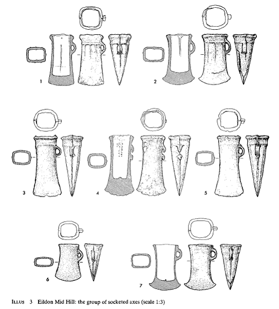
also is a Roman signal station. On Eildon Mid Hill
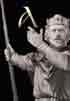
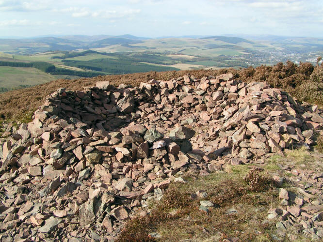
is a large Bronze Age cairn. The CANMORE database (of
the Royal Commission on the Ancient and Historical
Monuments of Scotland) has this on the cairn:
This
cairn is situated on the SW flank of Eildon Mid Hill
about 100ft below the summit, at a height of some 1285ft
OD. It has been much robbed and now appears as a low,
irregular mo und of stones, about 50ft in diameter, from
which a few boulders protrude to indicate the possible
former presence of a cist.
Merlin's
Chapel, the Bronze Age Cairn Atop Eildon Mid Hill (Photo
Courtesy John Young)
More
remarkable was the presence below the cairn of the
following (also from CANMORE):
A
group of seven bronze socketed axes, found on the lower
western slopes of Eildon Mid Hill in 1982, is now in the
Royal Museum of Scotland (RMS). More can be found on the
axes in the Proceedings of the Society of Antiquaries
of Scotland, Volume 115 (1985), pp.151-158. An
abstract of this article follows:
A group of bronze socketed axes
from Eildon Mid Hill, near Melrose, Roxburghshire
Brendan O'Connor and Trevor Cowief.
In 1982, a group of seven
socketed axes was found on the lower western slopes of
Eildon Mid Hill, Ettrick and Lauderdale District, Borders
Region. Although recovered from redeposited soil, the
axes probably represent a hoard of the Ewart Park phase
of the late Bronze Age. The find reinforces what appears
to be a significant local concentration of contemporary
metalwork around the Eildon Hills.
CIRCUMSTANCES OF
DISCOVERY
On 9 August 1982, several bronze
socketed axes were discovered by Messrs W and A Wilson (uncle
and nephew) on the margin of the rifle range on the lower
western slope of Eildon Mid Hill, the central and highest
of the three peaks which form one of the most conspicuous
landmarks of the Scottish Border country (illus 1 -2).
They were intending to use Mr William Wilson's metal
detector slightly further uphill in order to search for
shell-cases and cartridges in the area of the targets.
While they were walking up the roughly trodden grassy
path on the northern margin of the range, with their
detector switched on but not consciously in use, their
conversation was interrupted by a signal from the machine.
The tone indicated a non-ferrous metal, and closer
scanning with the detector suggested that there were at
least four soil anomalies within a small area. The
Wilsons decided to investigate the source of these
signals: clearance with a trowel of a small patch of the
tenacious turf revealed, to their surprise, not spent
ammunition but a socketed axe of bronze (catalogue no 7);
a second discrete signal was found to emanate from a
further axe (7) also lying on its own just under
the turf. The source of a third signal was revealed to be
a cluster of three axes lying close together (3-5). Realizing
the growing archaeological significance of their find,
and not wishing to disturb the site further, the Wilsons
responsibly left undisturbed in the ground the sources of
what by then appeared to be two further signals of a
similar nature. They replaced the disturbed turf as best
they could to mask the site, and immediately reported
their discovery to the Ancient Monuments Division of the
Scottish Development Department, one of whose Inspectors,
Dr N Fojut, in turn notified the National Museum. On 17
August, one of the writers (TGC) visited the finders to
inspect the axes already recovered and to view the site
of their discovery, and the following day, he and Mr lan
Scott of the NMAS, with the assistance of Aidan Wilson,
investigated the immediate area of the find (NGR NT
542325).
A
small trench, 2m by 2m, was set out centred on the find-spot
of the cluster of three axes already removed (cf illus 1,
d). Following removal of the coarse turf, the points from
which the five axes had been retrieved became clear:
these showed up as irregular depressions in what appeared
to be the natural subsoil of reddish clayey loam with
plentiful stones (mostly the local felsite). Scanning of
the trench with the detector relocated the positions of
the two signals not investigated by the Wilsons the
previous day. One of these emanated from a slightly
darker patch of humic soil: on removal, this proved
simply to be a deeper pocket of topsoil, occupying a
slightly damper, clayier depression in what seemed once
again to be the natural subsoil. A further socketed axe (6)
lay at an angle on the side of the depression 10-15
cm below the present ground surf ace: perhaps on account
of the damper matrix, the axe was in a noticeably more
corroded condition than the others when found.
Surprisingly, the source of the
final signal appeared to emanate from natural subsoil
with no obvious trace of any feature on its surface.
Removal of a small area of this supposedly natural 'subsoil'
revealed the source of the remaining signal to be a
further axe (2) and threw some light on the context of
the group of axes as a whole. It became clear that this
last axe was not, as first thought, lying in undisturbed
ground, but rather was lying in compacted redeposited
soil apparently occupying the side of a natural gully or
channel in the hillside. In the time available, it was
not possible to excavate the presumed channel nor
determine its width or depth, but the circumstances which
led to the incorporation of redeposited soil in natural
features seem clear enough for the construction of the
rifle range must have involved considerable smoothing out
of the contours and irregularities of the hill-slopes.
Churning up of the ground, the infill of erosional
features such as gullies caused by water run-off, and the
compaction of the area by machines could account for the
formation of the deposit on and in which all seven axes
lay. Indeed, gullies of the type envisaged can be seen
elsewhere on the slopes of the Eildons (see illus 2). The
axes are likely to have been moved bodily in a load of
earth and soil, dumped and then slightly dispersed (axes
2 and 6 were separated by a distance of 1-5 m). Following
the removal of the final two axes, the excavated soil and
turf were replaced and the site restored to its original
appearance as far as possible. Finally the surrounding
area was scanned with the metal detector, but no further
non-ferrous anomalies were noted…
THE ORIGINAL DEPOSITION
OF THE AXES
In view of their discovery in
redeposited soil we cannot be absolutely certain how the
axes were originally deposited. However, their number,
their proximity and their similar condition all suggest
that they came from a hoard, probably close to their
eventual find-spot. Whether the seven axes recovered in
August 1982 comprised the whole hoard remains uncertain.
On the other hand, it is possible, though less likely,
that more than one separate deposit was originally
involved…
I
would see in ‘Noquetran’ or Noquetrant a Gaelic
cnoc or Anglicized ‘knock’ plus one of the
following:
G.
dreann – grief, pain (cf. Irish drean,
sorrow, pain, melancholy)
G.
treana, treannadh – lamentation, wailing
In
other words, Noquetran is merely a Gaelic rendering of
the Old French Mont Dolorous!
The
bronze hammer Fergus causes to be dropped near
Merlin’s Chapel on the Noquetran is a folk memory of
a bronze socketed axe being deposited on the slope below
the Eildon Mid Hill cairn or, more probably, of such an
axe being found on the site prior to Guillaume Le
Clerc’s writing of the Fergus romance.
Merlin’s Noquetran chapel is the Eildon Mid
Hill Bronze Age cairn.
Melrose
Mountain, Black Mountain and Castle of the Dark Rock are
all designations for the Eildons. The hill-name
Eildon is found in 1130 (_Place-Names of Scotland, 3rd
Edition, James Brown Johnston) as Eldunum and in 1150 as
Eldune. While various etymologies have been
proposed, the most commonly favored one is G. aill,
“a rock, cliff”, plus OE dun, “a
hill”. The “Fergus” romance’s
“Castle of the Dark Rock” (Li Chastiaus de la
Roce Bise) may stand for the hill-fort on Eildon North
Hill, with Eildon being perceived as composed of aill,
rock, plus not dun, “hill”, but instead - “OE
dun, a colour partaking of brown and black; ME dunne,
donne, dark-coloured: Ir. Dunn, a dun colour: Wel. Dwn,
dun, swarthy, dusky: Gael. Donn, brown-coloured”
[From Toller’s and Bosworth’s Anglo-Saxon
Dictionary]
So
why were the Eldons identified with the Dolorous Mountain/Noquetran?
The answer may lie in part with Nikolai Tolstoy’s
astute observation that the lion Fergus thinks should be
roaming over the mountain-top, but which he finds inside
the ‘chapel’ is an error or substitution for
the god Lugos (Welsh Lleu, Irish Lugh). In Welsh,
Lleu’s name could sometimes be spelled Llew, and the
latter is the normal spelling for the Welsh word
“lion”. Merlin’s associations with
Lleu will be briefly discussed below. For now,
suffice it to say that the Dolorous Mountain undoubtedly
got its name because Lugos or Lugh was at some point
wrongly linked to Latin lugeo, “to mourn, to lament,
bewail”. Such mistakes in language could
easily have occurred when going from Celtic to Old French.
The
Dolorous Mountain is thus, properly, “Lugos
Mountain”. And the Lugos/Lugh/Lleu mountain is
particular is Eildon Mid Hill, the highest of the Eildons,
with its Bronze Age cairn. Such an
identification of the Dolorous Mountain has implications
for the Dolorous Garde of Lancelot, especially given that
Lancelot himself is a late literary manifestation of the
god Lugh, something first discussed long ago by the noted
Arthurian scholar Roger Sherman Loomis.
We
know of five Lugh forts in Britain, four known and one
unlocated. Of the former there is Dinas Dinlle in
Gwynedd, Loudoun in East Ayreshire, Luguvalium or
Carlisle in Cumbri and Lleuddiniawn or
“Lothian”, land of the Fort of Lugh.
Luguvalium has been interpreted as containing a personal
name *Lugovalos, ‘Lugos-strong’, but I believe
this name is instead a descriptive of the fort itself as
being ‘Strong as Lugh’. Dr. Graham Isaac,
a Celtic language specialist at The National University
of Ireland, Galway, agrees with me that this could well
be the case.
Then
there is the Lugudunum or “Hill-fort of Lugh”
of the Ravenna Cosmography. This place is (see
Rivet and Smith’s “The Place-Names of Roman
Britain”) situated somewhere roughly between Chester-le-Street
and South Shields. The only good candidate would
seem to be Penshaw Hill, which the Brigantes Nation
Website calls “the only triple rampart Iron Age hill-fort
known to exist in the north of England.”
Penshaw Hill is associated with the famous Lambton Worm,
a monster not unlike the two worms or dragons of
Lleu’s hill-fort of Dinas Emrys in Gwynedd, Wales.
The
Eildons are noted for the stories of “Canobie”
or Canonbie Dick and Thomas the Rhymer of Ercildoune.
Canonbie is near to both the Carwinley of Myrddin’s/Merlin’s
lord Gwenddolau and Arthuret Knowes, the scene of the
Battle of Arfderydd in which Myrddin was driven mad.
The 13th century Thomas is credited with
meeting an elf-woman under the Eildon Tree (whose
location is now marked by a stone) and being taken under
the Eildons to the land of Faery. He is also
credited with a prophecy concerning Merlin’s grave
at Drumelzier:
When
Tweed and Powsail meet at Merlin’s grave,
Scotland and England that day ae king shall have.
[According
to P.C. Bartrum in “A Welsh Classical
Dictionary”, under his entry for Llallogan, this
prophecy was first published by Alexander Pennycuick in
1715.]
The
story of Canonbie Dick presents Thomas as a wizard from
past days, and I will quote it in full:
A
long time ago in the Borders Region there lived a Horse
Cowper (trader) called Canobie Dick. He was both admired
and feared for his bold courage and rash temper. One
evening he was riding over Bowden Moor on the West side
of the Eildon Hills. It was very late and the moon was
already high in the night sky.
He had been to market but trade that day had been poor
and he had with him a brace (pair) of horses, which he
had not been able to sell. Suddenly, he saw ahead of him
on the moonlit road, a stranger. The stranger was dressed
in a fashion that had not been seen for many centuries.
The stranger politely asked the price of the horses.
Now Canobie Dick liked to bargain, and was not worried by
the strange man's looks. Why, he would have sold his
horses to the devil himself, and cheated him as well,
given half a chance. They agreed a price which the
stranger promptly paid.
The only puzzle was that the gold coins he used to pay
were as ancient as his dress. They were in the shape of
unicorns and bonnet pieces (Scottish coins from 1400s and
1500s). However, Canobie Dick shrugged his shoulders.
Gold was gold. He smiled to himself, thinking that he
would get a better bargain for the coins than the
stranger had got for the horses.
When the stranger asked if he could meet him again at the
same place, Canobie Dick was happy to agree. But the
stranger had one condition: that he should always come by
night and always alone.
After several more meetings, Canobie Dick became curious
to learn more about his secret buyer. He suggested that 'dry
bargains' were unlucky bargains and that they should seal
the business with a drink at the buyers home.
"You may see my dwelling if you wish," said the
stranger; "but if you lose courage at what you see
there, you will regret it all your life."
Canobie Dick was scornful of the warning, after all he
was well known for his courage and the stranger seemed
harmless enough. The stranger led the way along a narrow
footpath, which led into the hills between the Southern
and central peaks to a place called the Lucken Hare.
Canobie Dick followed but was amazed to see an enormous
entrance into the hillside. He knew the area well but had
never seen before such an opening or heard any mention of
it.
They dismounted and tethered their horses. His guide
stopped and fixed his gaze on Canobie Dick. "You may
still return," he said. Not wanting to be seen as a
coward, Canobie Dick shook his head, squared his
shoulders and followed the man along the passage into a
great hall cut out of the rock.
As they walked, they passed many rows of stables. In
every stall there was a coal black horse, and by every
horse lay a knight in jet black armour, with a drawn
sword in each hand. They were as still as stone, as if
they had been carved from marble.
In the great hall were many burning torches. But their
fiery light only made the hall more gloomy. There was a
strange stillness in the air, like a hot day before a
storm. At last they arrived at the far end of the Hall.
On an antique oak table lay a sword, still sheathed, and
a horn. The stranger revealed that he was Thomas of
Ercildoun (Thomas the Rhymer) the famous prophet who had
disappeared many centuries ago.
Turning to Canobie Dick he said, "It is foretold
that:
He that sounds the horn and draws that sword, shall, if
his heart fails him not, be king over all broad Britain.
But all depends on courage, and whether the sword or horn
is taken first. So speaks the tongue that cannot lie."
The stillness of the air felt heavy. Canobie Dick wanted
to take the sword but he was struck by a supernatural
terror, such as he had never felt before. What, he
thought, would happen if he drew the sword; would such a
daring act annoy the powers of the mountain?
Instead he took the horn and with trembling hands put it
to his lips. He let out a feeble blast that echoed around
the hall. It produced a terrible answer. Thunder rolled
and with a cry and a clash of armour the knights arose
from their slumber and the horses snorted and tossed
their manes.
A dreadful army rose before him. Terrified, Canobie Dick
snatched the sword and tried to free it from its scabbard
(sheath). At this a voice boomed:
"Woe to the Coward, that ever he was born,
Who did not draw the sword before he blew the horn"
Then he heard the fury of a great whirlwind as he was
lifted from his feet and blasted from the cavern. He
tumbled down steep banks of stones until he hit the
ground. Canobie Dick was found the next morning by local
shepherds. He had just enough trembling breath to tell
his fearful tale, before he died.
A
similar story is told of Alderley Edge in Cheshire, only
in that version the wizard is Merlin and the sleeping
knights are King Arthur and his men. My guess
is that in the case of the Canonbie Dick story, Thomas
the Rhymer has taken the place of Merlin. This is
not a new supposition, but combined with my
identification of Myrddin’s Noquetran with Eildon
Mid Hill as the Dolorous Mountain, the argument is
significantly strengthened. For “Fergus”
was written around 1200 AD, while Thomas is thought to
have lived c. 1220-1298. At some point Thomas was
substituted for Merlin at his chapel/cairn on Eildon Mid
Hill.
If I am right and the Eildons are
Merlin’s Mountain at the center of the great
Celyddon Wood, then we can allow for the Celyddon as
being thought of as the ancient woodland which covered
much of the area surrounding the Eildons. When we
combine this with the fact that Merlin was obviously
wandering in the wood in the vicinity of Drumelzier when
he was captured by Meldred, it is fairly obvious that the
Celyddon, which in this context means merely a great
forest of the Scottish Lowlands, extended at least to the
Lammermuir Hills in the north and perhaps as far as the
Cheviots in the east.
As the Roman Dere Street crosses the
Teviot near Jedburgh and the Tweed at Newstead, and four
of Arthur’s other battles were fought on or near
Dere Street, it is likely that Arthur’s Celyddon
Wood battle was fought in part of this ancient woodland
on or near Dere Street somewhere between Teviotdale and
Lauderdale.
Indeed, there were four great ancient
forests surrounding the Eildon Hills: the Jedforest,
whose Capon Tree oak is one of the oldest such trees in
all of Britain; Teviotdale itself, which was covered by
huge oaks and ash trees in the 12th century;
the Ettrick Forest of Selkirkshire; the Lauder Forest, an
immense forested track encompassing Lauderdale that still
existed up until the 17th century.
Apples, or rather crab-apples, the very species of tree
Merlin takes refuge under in the early Welsh poetry, were
also present in this region. The St. Boswell’s Apple
is thought to be 150 years old and is the largest of its
kind in Scotland. Thomas the Rhymer, taken to
Fairyland at the Eildons, is given an apple by the Queen
of Fairy.
We may be able to pinpoint the location of
the Coed Celyddon battle for precisely. Although
Geoffrey of Monmouth has been justly criticized for
producing stories of early British kings rather than
histories, we cannot discount the possibility that at
least occasionally his account of Arthur’s reign may
preserve accurate historical traditions. When he
has Arthur face the Saxons in the Caledonian Wood, he
tells us that
“Arthur… ordered the trees round that part
of the [Caledonian] wood to be cut down and their trunks
to be placed in a circle, so that every way out was
barred to the enemy. “
This circular palisade Arthur constructs
in the Caledonian Wood made me think of the semi-circular
Catrail dyke. To quote the description of the
Catrail from the Royal Commission on the Ancient and
Historical Monuments of Scotland (courtesy Mark Douglas,
Principal Officer for Heritage and Design, Planning and
Economic Development, Scottish Borders Council):
“This is the linear earthwork,
known as the Catrail which runs from Robert’s Linn
to Hosecoteshiel and embraces the entire head of the
Teviot basin from the Slitrig to beyond the Borthwick
Water. It is not continuous, in the sense that is
incorporates streams or woodland, and its engineering, in
short sectors clumsily joined and imperfectly aligned,
stamps it as a product of somewhat inexperienced communal
effort. The date of its construction is doubtful,
though it is certain that it fits only Anglian
territorial dispositions. Oman notes the opinion
that it might mark a political boundary after
Aethelfrith’s victory at Degsastan in 603, and this
is indubitably the earliest possible date for such a work.”
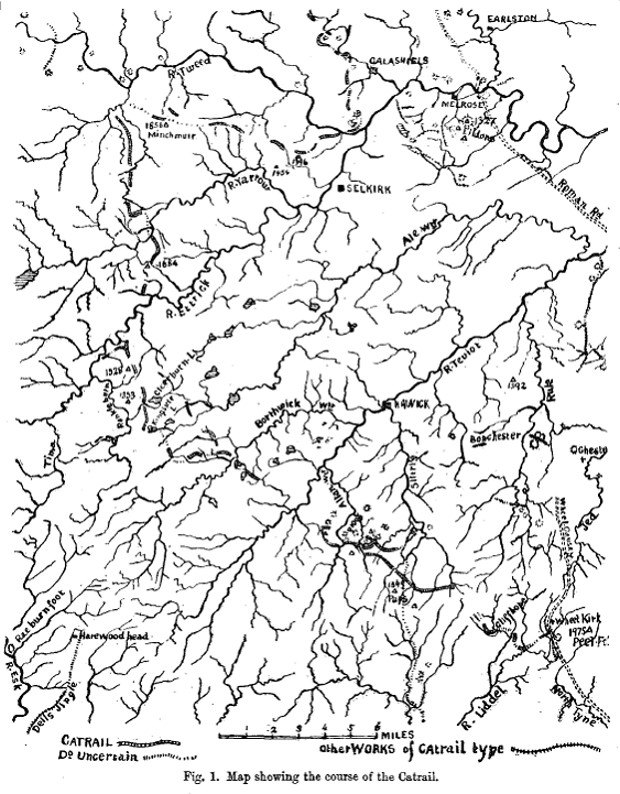
As the date of the construction of
the Catrail is “doubtful”, could we not propose
that it was built slightly earlier, say in the 6th
century, the time of Arthur? The Catrail runs
through what was the great Ettrick Forest, an extensive
woodland which according to Nicola Hunt, Projects Officer
of the Borders Forest Trust (private communication),
‘covered from Dumfriesshire to the Galashiels
area’. Thus this forest was very near to
Merlin’s Eildon Mid Hill.
The derivation of the name Catrail
has been disputed. The most commonly disseminated
etymology is Cymric cad or cat, ‘battle’, plus Cymric
rheil or rhail, wrongly defined as ‘fence’,
probably for a presumed wooden palisade that may have
once existed atop the dyke’s bank.
Unfortunately, as rheil or rhail does not mean
‘fence’. It is ‘rail, track’
and is not attested in Welsh until the 18th century.
According to Professor Richard Coates (Onomastics and
Director of the Bristol Centre for Linguistics at UWE,
and Hon. Director of the Survey of English Place-Names) rheil/rhailis
doubtless a borrowing from English and so Catrail cannot
be derived from Cat + rheil/rhail.
A cad/cat + rhigol (the ‘rhill’
mentioned below), the latter being Welsh for ‘rut,
groove, (long narrow) channel; trench, furrow, ditch,
gutter’, cannot have become Catrail – even
through a process of Anglicization. Rhigolis
pronounced something like “wriggle”.
Again, Professor Coates has assured me that a
hypothetical Cad + rhigolcannot have become Catrail.
This is so despite the attractiveness of “Battle-ditch”
as a meaning for the earthwork’s name.
Dr. Andrew Breeze, the Celtic onomastic expert in Pamplona,
has assured me that rhigol “is unknown before the
sixteenth century and is a loan from English”.
Helen Darling, Part-Time Local
Studies Librarian, Library Headquarters, St. Mary’s
Mill, Selkirk, was kind enough to send me the following
on this feature-name:
“KENNEDY, William Norman:
Remarks on the ancient barrier called "The Catrail",
with plans In Proceedings of the Society of
Antiquaries of Scotland 1857-1860 pp117 - 121
Considerable diversity of
opinion exists as to the derivation of the term, it being
variously stated by different authors. Chalmers
calls it "the dividing fence", or "the
partition of defence"; Jeffrey, "a war fence or
partition - Cat signifying conflict or battle, and Rhail
a fence"; others from Cater a camp, and Rhail a
fence, a dividing fence among the camps; others, again,
from Cud a ditch, and Rhail a fence, the ditch fence or
boundary; while another class call it "the Pictswork
ditch", attributing the formation of it, and all
other ancient artificial remains in the district through
which it passes, to the Picts, - a race regarding
whom very mythical traditions continue to float
about and receive credence; but almost all writers concur
in attributing its formation to the Britons, subsequent
to the withdrawal of the Romans from this country.
CRAIG-BROWN, T. The
History of Selkirkshire or Chronicles of Ettrick Forest.
Vol. I The Shire - The Parishes of Ettrick, Kirkhope,
Yarrow, Roberton, Ashkirk, Innerleithen, Peebles, Stow,
and Galashiels. Edinburgh: David Douglas, 1886, page
47
Concerning the origin of the word
"Catrail" there have been as many different
suggestions as about its purpose:
CHALMERS. - Cad, a striving to keep;
and Rhail, a division. Together - the dividing
fence.
JEFFREY. - Cat, a struggle; and Rhail.
Together - a war-fence.
MACKENZIE. - (Quoted by Gordon).
An old Highlandword signifying wall or ditch of
separation.
VARIOUS. - Cater, a camp; and Rhail.
Cud, a ditch; and Rhail. Cad-rhill - war-trench.
MISS RUSSELL. - Cader (Welsh), a
defence; and Rail.
An amateur philologist has
ventured to suggest the Saxon words camp-trail as at all
events a possible origin, but the probabilities are in
favour of a British or Cymricderivation; and we incline
to cater-rhail, a camp fence. Cater, Celtic for
camp, as in the celebrated Cater-thun, is undoubtedly
derived from the Latin, castra. Until the Romans
came, there was no need for such a word in the native
vocabulary, and it must be kept in mind that the diggers
of the Catrail were Romanised Britons.
That there was along the Catrail
a terrible struggle for supremacy between the Cymriand
the Saxons may be inferred from the frequent occurrence
of names beginning with the word "Cat", or
"Cad", Cymric for battle or conflict. Nor
far from its northern end is Cat-pair, and nearer, Cat-ha(?).
Caddonwe have seen derived from Cad afon, battle river.
Cat Craig is a hill on Tinnis farm in Yarrow, traversed
by the Catrail. A little further up is Catslack,
and there are pools near by known as Cat Holes.
Finally, near the end of the trench is Catlee. It
is necessary, however, to be on one's guard against
etymological inferences, and these names are submitted
with due reserve.”
The noted Scottish place-name expert
Watson said that the Catrail name ‘may be compared
with Powtrail [now Potrail], the name of a head-stream of
Clyde’ whose ‘meaning is obscure’.
As Henry Gough-Cooper of the Scottish Place-Name Society
confirmed, the Pow- of Powtrail is almost certainly Cymric
pwll, ‘pool’, but also ‘stream’.
After noticing on the map that the Powtrail
has many pronounced bends or turns, I would follow
Professor Richard Coates’ (Onomasticsand Director of
the Bristol Centre for Linguistics at UWE, and Hon.
Director of the Survey of English Place-Names) suggestion
of Welsh traill, ‘turn, a turning’, as the
stream’s second component, supplying us with a
meaning of ‘stream that turns’ or the ‘turning
stream’.
There is precedence for connecting traill
with a stream or river-name: Chepstow’s earlier
Welsh name was Ystraigl or Ys-traigl, ‘a turn’,
this being a reference to the bend of the River Wye at
the site of the town.
However, such a derivation for Powtrail
does not help us with the Catrail name.
Henry Gough-Cooper of The Scottish
Place-Name Society has informed me that Alan James
prefers a different etymology for the Powtrail. In
his paper ‘A Cumbric Diaspora?’ (in ‘A
Commodity of Good Names’, ed. Padel and Parsons,
Shaun Tyas 2008), James mentions the Catrail in a
footnote on Powtrail, which he speculates may be Cumbric
“*polter-eil ‘stream of a wattle fence of
woven hedge’: for *eil see ‘The Poems of
Taliesin’, ed. I. Williams (Dublin 1968), pp. 85-6.”
According to Gough-Cooper, *Polter is
stream-naming word found in northern Cumberland, parts of
the Solway basin and south-west Cheviots, e.g. see EPNS
Cumberland I, 8, 24, 62; II, 373; plus Polterkened in the
Lanercost Cartulary. Alan James suggests perhaps *pol +
extension *duvr, the latter being the word for ‘water’.”
One might compare for this last element the river-names Kielder
and Calder, both from Welsh caled, ‘hard’, and dwfr
(OBrit dubro-), ‘water, stream’.
Williams, on the pages cited by James,
says that:
“Eil was used of any sort of construction
involving plaiting, wattling, and
presumably would denote a defensive construction... Cf.
perhaps Irish aile, ‘a fence’…”
The problem with the –ail of
Catrail being the word for ‘fence’ is what to
make of the first component, Catr-.
I would propose that the first
component was derived from Gaelic cathair, 'fort'. Even
though, as Dr. Richard Coates has made clear to me, the
medial th in cathair is silent (cf. Welsh caer, 'fort')
and should not have yielded Catr-, in Highland Scotland
we do find the Brown and White Caterthun (cathair + dun)
forts. If cathair could become cater in these names,
certainly it could have become the Catr- of Catrail.
But if the Catrail is the ‘Fort-fence’,
what fort are we talking about?
John Barber, Elaine Lawes-Martay and
Jeremy Milln (in “The Linear Earthworks of Southern
Scotland; Survey and Classification”, Transactions
of the Dumfriesshire and Galloway Natural History and
Antiquarian Society, Series III, Volume LXXIII, 1999),
summarize their study of the Catrail thusly, bringing the
dyke into connection with the fort next to Merlin’s Eildon
Mid Hill, the center of the Celyddon/Caledonian Wood:
“The natural segmentation
of the Scottish landscape into separate territories may
also account for the relative absence of sites used as
local-administration boundaries. These administrative
units are usually fairly clearly defined by the nature of
the terrain and separated from each other by distinct,
natural features, such as ranges of hills of mountains.
This factor may also account for the paucity of lengthy
earthworks. Of those examined in this study only the
Catrail seems likely to have functioned as a large scale
territorial boundary. In association with other natural
features, it may have functioned in respect of the
hillfort of North Eildon Hill in the same role as the
earthwork called ‘The Dorsey’ seems to have
functioned in respect of the royal site of Eamhain Macha
(Lynn 1981). The discovery that the line of the Dorsey is
continued across an apparent gap, once bogland, by a
wooden palisade perhaps points to new avenues of approach
to similar areas on the Catrail.”
In the same Transaction of the
DGNHAS the Catrail is described in detail:
| The Catrail by Jeremy Milln Prior to this
report, as many as fifty writers have mentioned
the Catrail, the most recent being the RCAHMS
which, in the autumn of 1945, carried out the
only previous systematic survey (RCAHMS, 1956).
All those portions given credence by RCAHMS (and
many other earthworks which have on occasion been
hypothesized as forming part of the Catrail),
were re-surveyed by the CEU in 1984. The major
part of the earthwork examined in 1945 had
survived, but increasing land-use pressure includingforestry,
drainage and cultivation, has been responsible
for a rapid deterioration in its overall
condition. The erroneous but popular concept of
an earthwork extending for some 86 kmin a broad
arc from Peel Fell on the border with
Northumberland to Torwoodlee, north of Galashiels,
was first expressed in the Itinerarium Septentrionale
(Gordon 1726, 102-4). Chalmers (1886, 240-3)
regarded it as having formed a frontier between
Romanized Britons in the west and the Saxons in
the east, running from the Forth to the Tyne, and
including the Northumbrian Black Dyke. Murray (1864,
37-8) seems to have been the first to point out
that the Catrail incorporates two separate and
distinct earthworks. Craw’s plan of 1924 (Craw
1924, 42) shows one segment running from Roberts
Linn to Hoscoteor possibly Clearburn, and a
second, the Pictswork, extending from LinglieHill
to Torwoodlee near Galashiels.Some succeeding
writers were prepared to accept the curtailed
Catrail, but Smail (1879) and particularly Lynn (1898)
adhered in detail to the older theory. Lynn’s
account is the more meticulous, but he was unable
to distinguish between the true linear earthwork
and the intermittent remains of old 80 GAZETTEER
OF GROUP 1 SITES roads and field-boundaries; most
notable is his misinterpretation of branches of
the Minchmoor Roadin Selkirkshire, which have
since been clarified (Inglis 1924, 205-6). The
RCAHMS account of the course of the Catrail (1956,
479-83), as well as for the Pictswork (1957, Nos
126-7), is questionable only in matters of minor
detail. The course of the Catrail is shown in Fig.
3. The following account examines it sector by
sector beginning at its alleged origin at Peel
Fell, on the border (Gordon 1726, 102). Earlier
reports suggest thatthe Catrail ran for about 9
kmfrom Peel Fell to Roberts Linn via the Wormscleuch,
Liddel, Dawston and Cliffhopevalleys. The only
definite linear earthwork now visible on this
line is an indeterminate fragment at CaddrounburnCulvert
(152). As the RCAHMS survey points out (1956, 480),
the topography of the steep-sided Roberts Linn
forms a convenient natural break to its course
here.
With the exception of a 350 m gap to the west of
the Langside Burn (281) the earthwork from
Roberts Linn is continuous as far as the head of Barny
Sike(282) and it is only beyond this point that
uncertainty occurs. Smail (1879, 113), following
Gordon and Chalmers, asserts that it crossed WhitehillLower
to the north of the enclosure; there is indeed a
linear earthwork at this height (201), but no
evidence of a connection past Pyot’sNest (NT
4817 0530). Furthermore, this earthwork is
markedly off line with the bank on the south side
of the ditch. This suggests that it is one of a
number of linear outworks delimiting the ground
around Pyots’ Nest fort on its landward side
where it is overlooked by Whitehill. A short
length of linear outwork passing close to the
south-west side of the enclosure at the Dod (NT
4727 0602) is aligned on 201 and could perhaps be
considered part of the Catrail (Ian Smith, pers comm),
but it is isolated and nowhere recognized in the
literature. Elsewhere, the line of the Catrail
incorporates streams, suggesting that the course
from the head of Barny Sikemight be along Barny Sikeitself
and the DodBurn. The next section would thus seem
to be 283 and, though this earthwork is
discontinuous, for the most part its character is
similar to that recognized elsewhere. RCAHMS (1956,
No 481) suggests its sudden extinction above Priesthaughmight
be explained by an area of valley side scrub
carrying the work to the top of 284, 900 mto the
north. It is debatable whether the short stretch
of bank from Peel Brae to the Dod-Priesthaughroad
continued west across the road to the earthwork
on the Allan Water; though Lynndoes record a cropmarkin
the cultivated field (Lynn 1898, 79). The
connection with the Allan Water, which almost
certainly maintained the line to Doecleuch, might
alternatively be made by a 300 mlength of
earthwork, consisting of a ploughed-down bank,
running along the valley floor north of the farm
at Priesthaugh (288). The next surviving fragment,
285, lies on the north-west slopes of DoecleuchHill,
and continues the RCAHMS Inventory entry (1956,
No 481), which cites a point (NT 460 061) on the
south-east of that hill. The area is disturbed by
rig and furrow and it was not discernable in the
present survey. It is possible however,that the
work ran from the steep lip of Doecleuchat NT
4609 0634 to join the truncated end of 285 at the
DodBurn-TeindsideRoadand part of the line of this
is preserved by an old footpath. 285 may have
continued as far as Chapel Cleuch, just south-west
of Old Northhouse (it is marked on a plan of 1857
inthe library of the Society of Antiquaries of
Scotland), but the area is now marshy and no
earthwork can be distinguished. The course of the
Catrail, as far as the Muselee Burn, continued by
the Northhouse and TeindsideBurns and 286, has
never been disputed. Lynn (1898, 73) claimed that
a short length was to be seen on the west side of
the MuseleeBurn opposite the north-west end of
286, but he seems to have been misled by a track.
By implication, it ran north/north-west across
the rough pasture to pass close by the west side
of the enclosed earthwork at Broadlee. As the
latter certainly belongs to the enclosure, there
can be no doubt that the work was continued to
the Borthwickvalley by the MuseleeBurn. THE
LINEAR EARTHWORKS OF SOUTHERN SCOTLAND 81 Many
writers (Smail 1879, 113; Lynn 1898, 78; Craw
1924, 42) assume that 134 continued the earthwork
from the head of a dry gully above the Hoscotepolicies.
The RCAHMS rightly recognizes this as a work of a
completely different trend and follows Kennedy (1860,
121) in accepting 287 as bridging the hiatus
between the south end of this earthwork and the HoscoteBurn,
with a course meeting the burn at NT 3845 1115.
The case for accepting 287, though, is not proven,
as this earthwork shows evidence of recent
modification, perhaps as a field boundary, and
the characteristics of the Catrail, if they
existed, are obscured. Lynn’s idea of a
‘branch line’ continuing north-west
past Hoscoteshielto include 12 should therefore
be dismissed. Murray’s theory (1864, 37)
should also be mentioned here, namely that the
work terminated not on the Dean Burn but on the
Clear Burn. Two earthworks, Quarry Rig (14) and
Clear Burn (10), carry on the line from near the
upper end of the HoscoteBurn to a point just
above the head of Buck CleuchLinn. The remains of
both earthworks are badly damaged by drainage and
afforestation, but their alignment and character
are similar to that of the Catrail proper (see
below). The sectors of the ‘core
monument’, to which the name Catrail has
been restrictedare as follows - 281 Catrail (NT
5385 0262 to NT 5005 0365; 259-322 m OD; 4140 m)
Roberts Linn - LangsideBurn The largest
continuous portion of the true Catrail. Runs west
from the mouth of Roberts Linn across the north
ridge of Leap Hill to the west/north-west as far
as the Langside Burn, a distance of c 4 km.
Crosses 11 small burns flowing north into the Slitrig
Water and the spurs and ridges between,
irrespective of contour. Clearly visible, but in
poor condition.On steep slopes its character has
been degraded by natural surface drainage and on
the more level ridge tops it has been obscured by
the accumulation of peat. Consists of a low,
rounded bank with a ditch, generally the more
noticeable feature, on the uphill side.Today it
rarely exceeds an overall width of 6 mand height
of 0.5 m. Peat accumulation may account for some
of the considerable diminution since it was first
recorded 250 years ago. RCAHMS notes a
counterscarp bank in one place which has vanished
since 1945, but generally the work is not badly
affected by human activity. Entire portion now
covered by plantations within which it occupies a
generous corridor, although a number of narrow
surface drains cut the work, but vulnerable to
damage in the course of thinning and felling and
by heavy machinery using the break in which it
lies. 282 Catrail (NT 4975 0405 to NT 4815 0502;
30-451 mOD; 1970 m) Foot of the Pike - Barny SikeThis
earthwork, visually the most impressive surviving
portion of the Catrail proper, extends from the
upper limit of once cultivated land to the west
of the LangsideBurn. Runs steeply across the
ridge of the Pike, across the PenchriseBurn and a
further, lower ridge of high ground to terminate
at the head of the Barny Sike, a feeder stream of
the DodBurn. Largely as described by RCAHMS with
a definite ditch traceable over most of its
course, flanked on the north/north-east by a main
bank and on the south/south-west by a slighter
counterscarp bank. It is obscured by peat moss on
the more level ground at the summit of the Pike,
in the valley of the PenchriseBurn, and on the
moor to the west of the modern track from Peelbraehopeto
Stobs, but the general character of the work is
clear, with overall dimensions of 5.5-6.5 mwide
and 0.7-1.2 m high. Between the top of the Pike
and the modern track the earthwork is followed
closely, and at points crossed by, the present
boundary between the lands of PenchriseFarm and
those of the Forestry Commission. The
latter’s land was ploughed and planted in
1981 and it is evident that despite this portion
being scheduled, it has been badly disfigured, particularilyin
the area near the PenchriseBurn. 82 GAZETTEER OF
GROUP 1 SITES 283 Catrail (NT 4825 0575 to NT
4770 0590; 305-366 m OD; 480 m) Head of dry
hollow west of the DodBurn - Shoulder of Peel
Brae The position of this earthwork is somewhat
dislocated from the Catrail, but similarities in
its course and character allowed its acceptance
by the RCAHMS. Running from the head of a dry
linear gully to the west of the Dod Burn, it
ascends the ridge of Gray Coat along a slightly
sinuous course, is crossed by the property
boundary along the spine of that ridge and
finishes abruptly on the shoulder overlooking the
Allan valley. Consists of a ditch with a bank to
the north.RCAHMS suggests that its segmented
appearance is due to its construction in short
sections, however, the occurrence of localized
patches of moss and the considerable disturbance
wrought by an old track, the ‘Thieves’
Road’, and banks associated with 185 render
this observation most uncertain. 284 Catrail (NT
4675 0535 to NT 4630 0440; 259 m OD; 90 m) Foot
of Peel Brae - Modern Dod/Priesthaughroad
Consists of a broad low bank some 4 macross. No
ditch. Runs from near the foot of the steep Peel
Brae ridge where it has an abrupt, round terminus,
to the Dod/Priesthaugh road, by which it is
clearly cut. The RCAHMS has followed the received
opinion that it is part of the Catrail, although
the differences in form suggest that its position
and alignment may well be fortuitous. Abutted
near its upper end by a length of eroded head-dyke
running south. 285 Catrail (NT 4561 0672 to NT
4535 0672; 256-305 m OD; 340 m) DoecleuchHill/Gray
Hill - Old NorthhouseSwamp Visible on the west
side of the Teindside-Priesthaughroad between DoecleuchHill
and Grey Hill. Runs west, down to the edge of the
boggy ground south-east of Old Northhouse. Consists
of a ditch with a bank on the north and a slight
counterscarp bank to the south. Best-preserved at
east end near the road.There is a reduction in
the vertical dimension of both themainbank and
ditch to the west end, with the lowest 20 mmuch
modified by run-off and artificial drainage. Both
sides currently being eroded by ploughing.286
Catrail (NT 4133 0960 to NT 4047 1038; 271-297 m
OD; 1140 m) TeindsideBurn - MuseleeBurn Visible
in the moss at the head of the TeindsideBurn as a
large ditch, probably enlarged by seasonal
erosion. Runs north-west to the parish boundary
by which time the ditch is 0.35 mdeep: the main
bank to the north-east, 2.5 mwide and 0.25 mhigh,
and a counterscarp bank to the south-west, 1.6 mwide
and 0.1 mhigh. Easily traced to its termination
on the MuseleeBurn, with dimensions similar to
those above, though the counterscarp bank is
discontinuous. Towards the north end where the
work, unusually, is overlooked by high ground to
the north-east, the main bank changes to the
south-west side. Broken in four places by droving
tracks. Has suffered erosion from livestock.Obscured
by an area of peat moss just north-west of the
parish boundary. 287 Catrail (NT 3890 1160 to NT
3735 1135; 259-283 m OD; 520 m) North-east corner
cultivated lands of Girnwood - Tributary of the
Dean Burn Commences at the track which passes to
the north of the cultivated lands of Girnwoodand
borders a new conifer plantation. Runs north/north-west
across two small tributary streams of the Dean
Burn to end abruptly at the bank of a third.RCAHMS
regards only the southern two-thirds of this
length to THE LINEAR EARTHWORKS OF SOUTHERN
SCOTLAND 83 be part of the Catrail (NT 3890 1160
- NT 3796 1216) dismissing the remainder as being
‘probably an agricultural division’.
However, the line is unbroken and on the same
alignment, suggesting a common usage if not
origin. The ditch is 2.5 mwide, very shallow, and
with a bank on the east/north-east side and in
the former section only is an exiguous bank. The
main bank at some 0.8 mis surprisingly high,
which suggests that if this earthwork belongs to
the Catrail it has been raised and the ditch
widened, giving credence to the RCAHMS suggestion
that it was used as an agricultural division; the
current boundary, a stone wall, runs alongside.
Much of the earthwork now runs within a young
conifer plantation and the drainage ditches
associated with this development cut it in a
number of places. 288 Possibly Catrail: Priesthaugh
(NT 4646 0480 to NT 4660 0510; 219-223 mOD; 300 m)
Runs from the edge of a small copse of deciduous
trees across the valley floor north of PriesthaughFarm
to a thicket. Consists of a low, rounded bank,
much reduced by cultivation, and a very slight
ditch on its east side.The bank is nowhere
greater than 0.3 mhigh, its cropmarkbeing some 3
mwide. Runs along a gap in the line of the
Catrail, but it may simply represent an old
drainage dyke. 289 Possibly Catrail: DoecleuchHill
(NT 4562 0640 to NT 4561 0672; 305-312 mOD; 310 m)
Runs from the south end of Gray Hill along the
ridge of DoecleuchHill just east of its crest,
through a mature conifer plantation towards the
middle of a large field of improved pasture.
South end severely damaged by cultivation. North
end overrides the filled ditch of the Catrail (285)
and abuts its bank close to the modern road
between Teindside and Dod.
Where both are still visible, the bank (2 mby 0.25
m) lies on the east side of the ditch (1.5 by 0.3
m). Badly damaged by ploughing and plantation
trenches, the only well-preserved section being
the 15 m at the north end used as a field
boundary at present.Probably an early
agricultural dyke and not part of the Catrail.
|
THE NAME MYRDDIN
The best derivation for the name Myrddin
has been proposed by Dr. G. R. Isaac of The National
University of Ireland, Galway:
"The attested name MYRDDIN reflects
an earlier, not directly attested
*MYR-DDYN, with the second element DYN 'man, person', and
the first element
MYR- which is found in the name of the Old Irish goddess-type
figure
MORRIGAIN (who also prophesies), and in English night-MARE,
and also in
several Slavic words (see Indogermanisches etymologisches
Woerterbuch p.
736). The basic meaning was 'supernatural being, elf,
goblin, phantom' or the like. So *MYRDDYN was
originally something like 'elf-man'. Note his
patronymicon MYRDDYN FAB MORFRYN 'elf-man son of elf-hill'.
"The form Mórrígain with long vowel
in the first syllable, so 'Great Queen',
occurs from the Middle Irish period on, due to folk
etymology, as we call
it (the alteration of a form due to the mistaken belief
in a false
etymology). T. F. O'Rahilly thought this was the best
form, and enshrined
it in his EARLY IRISH HISTORY AND MYTHOLOGY, followed by
some later
commentators. However, O'Rahilly is no reliable source
for linguistic
analysis, and in this case, he is certainly wrong. As
Thurneysen had
already demonstrated in his DIE IRISCHE HELDEN- UND
KÖNIGSAGE, the form with long first vowel is late, and
the earlier, correcter, form is
Morrígain with a short vowel in the first syllable,
which cannot be
connected with the adjective mór 'great' which has a
long vowel (and of
which the earlier form is már in any case)."
This Myr-ddyn > Myrddin is a much more
satisfactory explanation than the previously offered
theory that Myrddin was derived from the city name of
Carmarthen, ancient Caerfyrddin, Roman Moridunum. This
last notion derives from the fanciful HISTORY OF THE
KINGS OF BRITAIN by Geoffrey of Monmouth. In this source,
Myrddin is found as a boy at Carmarthen. The whole story
is Geoffrey’s alteration of Nennius’s tale of
the boy Ambrosius being found at Campus Elleti in
Glamorgan.
THE CELYDDON WOOD AS THE LAND OF
SPIRITS
The ancient Classical writer Procopius (in
his HISTORY OF THE WARS, VIII, XX. 42-48) said:
“Now in this island of Britain
the men of ancient times built a long wall, cutting off a
large part of it; and the climate and the soil and
everything else is not alike on the two sides of it. For
to the south of the wall there is a salubrious air,
changing with the seasons, being moderately warm in
summer and cool in winter… But on the north side
everything is the reverse of this, so that it is actually
impossible for a man to survive there even a half-hour,
but countless snakes and serpents and every other kind of
wild creature occupy this area as their own. And,
strangest of all, the inhabitants say that if a man
crosses this wall and goes to the other side, he dies
straightway… They say, then, that the souls of men
who die are always conveyed to this place.”
From the Welsh poem "The Dialogue of
Myrddin and Taliesin" (BLACK BOOK OF CARMARTHEN), we
learn that at Myrddin’s Battle of Arfderydd:
Seven score chieftains became gwyllon
;
In the Wood of Celyddon they died.
Gwyllon or "Wild Ones" is a word
deriving from gwyllt, "wild". The Welsh epithet
for Myrddin is, of couse, Gwyllt. Myrddin Gwyllt is
Myrddin "the Wild".
But as Tolstoy pointed out, there is
something odd about these two lines. The gwyllon or
“Wild Ones” are equated with the
warriors who died in the battle! The word
“died” in the poem’s second line is Middle
Welsh daruuanan. Modern Welsh has darfyddaf or
darfod, which according to the authoritative
“Geiriadur Prifysgol Cymru” (A Dictionary of
the Welsh Language) has the following meanings:
To come to an end, end, conclude, finish,
complete, terminate, cease; expire, die, languish, weaken,
fail, fade, decline, perish
There is thus no ambiguity in the poetic
passage we are considering. The warriors who became
“Wild Ones” did not simply “go away”
or “disappear” – they died.
In this context, then, to become gwyllon means to become
a roving spirit that has left its battle-slain body
behind. To exist as a “Wild One” is to
exist in spirit-form after the death of the body.
The Christian medieval mind either could
not accept this notion of wandering spirits or, just as
likely, misunderstood it. The gwyllon were
transformed into living madmen who leapt or
flitted about the forest much as did their Irish
counterpart, Suibhne Geilt.
In another Myrddin poem, "Greetings"
(BLACK BOOK OF CARMARTHEN), we are told by Myrddin
himself:
The hwimleian speaks to me strange
tidings,
And I prophesy a summer of strife.
Hwimleian or "Grey Wanderer" is
yet another word for a spirit or spectre.
Myrddin "the Wild" was thus the
soul of a dead man, wondering the woods of Celyddon. We
must presume that it was believed that certain
individuals with necromantic skills could communicate
with or perhaps even channel such spirits and thus
extract from them information only available to the dead,
e.g. prophecies.
Difficult as it is for us to believe in
this modern age, ancestral spirits were once
worshipped or placated with offerings. The 'Dis
Manibus' or "For the Divine Spirits of the Dead"
was a common heading for Roman period memorial stones. Morddyn
the "Elf-Man" may have been such a spirit of
the dead.
In the case of Merlin, then, we have a
warrior-bard who is slain in battle at Arfderydd.
His spirit wandered the Lowland Scottish forest, but had
its proper home atop the Lugh Mountain of Eildon Mid Hill.
There, in “Merlin’s Chapel”, the Bronze
Age cairn whose interior symbolized the Otherworld/Underworld
and which was also a portal to the Otherworld, the
spirits of the dead who had worshipped Lugh in life
congregated. Although thanks to Geoffrey of
Monmouth and others Myrddin/Merlin came to be conflated
with Lugh or perhaps seen as a human avatar of the god,
the most judicious interpretation of the early sources
does not warrant such an identification of ghostly
warrior-bard with divine entity.
LAILOKEN
We need now address the problem of Myrddin's
identification with the madman Lailoken, W. Llallogan or
Llallawc. In his edition of Geoffrey of Monmouth's Life
of Merlin, Basil Clarke proposes that Myrddin was
originally a certain Llallawg or Llallogan who went mad
at Arfderydd. Lailoken/Llallogan, suggests Clarke, may
derive from a placename similar to the Gaulish village
Laliacensis, which was named after the family of Lollius
Urbicus, a second century Governor of Britain.
However, the word llallawc/llallogan (linked
to W. llall, "other", a reduplicated form of
ail/eil) is used in Welsh poetry, where it denotes
something like "lord" or "friend" or
"dear friend". W.F. Skene, in his The Four
Ancient Books of Wales, translates the word as "twin
brother". Ifor Williams translates it as "friend"
in The Poems of Llywarch Hen. Egerton Phillimore and A.O.H.
Jarmon make a case for it being a true personal name.
The crux of the issue is found in the
Welsh poem, "The Prophecy of Myrddin and Gwenddydd,
His Sister". There Gwenddydd addresses her brother
Myrddin as both Llallogan (once) and Llallawc (several
times). The question then is: are we to see Llallogan/Llallawc
as merely a term of endearment applied to Myrddin or as a
separate person with whom Myrddin was identified?
The MS. Cotton Titus A. XIX contains the
tales of "Kentigern and Lailoken" and "Meldred
and Lailoken". Jocelyn's 12th century
Life of St. Kentigern also mentions Lailoken in its last
chapter. In both, Lailoken is identified with Merlin.
In the story of Meldred and Lailoken,
Merlin suffers a triple death at the hands of Meldred's
shepherds. The triple death is a motif found in
Celtic literature and was a special kind of death meted
out to kings, heroes and gods alike. It is, in
essence, a form a human sacrifice, made sacred by the use
of three simultaneous methods of killing. In their
book The Life and Death of a Druid Prince, Anne
Ross and Don Robins hypothesize that each method of
killing was sacred to a specific god. The three
Celtic divinities in question have been tentatively
identified with Taranis the thunder god, Esus the lord
and master and Teutates, the overall god of the people.
Doubtless there were regional counterparts to these
deities.
Nikolai Tolstoy used the example of
Lailoken's triple death to more closely link Merlin with
the god Lleu/Lugh, as Lleu in Welsh tradition also
suffers a triple death.
The true importance of Merlin's triple
death on the Tweed near the Dunmeller of Meldred has been
overlooked, however. For it clearly demonstrates
that by the time of the composition of the Life of St.
Kentigern, any memory of the poetic device which
employed a state of madness to represent a post-death
spectral existence had been lost. No one understood
any longer that Merlin or, rather, Myrddin, had died at
the Battle of Arfderydd. And because his madness
was taken literally, a story was concocted which sought
to demonstrate his divine nature by making him the victim
of a three-fold human sacrifice.
That such a form of human sacrifice was
actually practiced has been proven by examination of the
Lindow Man, who was struck in the head by an axe, choked
with a garrote and drowned in a pool (see again The
Life and Death of a Druid Prince). By
undergoing such a sacred killing, the Lindow Man was
acting the role of a god like Lleu. And by acting
such a role, he became the god – a sun god who was
seasonally killed and reborn.
The corollary of the three-fold death
was, of course, resurrection. The god Lleu, who in
death is represented as a Jupiter-eagle in an
oak tree, was brought back to life by Gwyddion. The
Lindow Man as Lleu or a similar sun god, by
dying, helped insure the seasonal rebirth of the sun god.
For as the sun died each year, so was it reborn.
There cannot be life without death.
Merlin under his nickname Llalogan thus
becomes the god in death. But in life, he was a
warrior serving his lord Gwenddolau, who also perished at
Arfderydd.
The model for Myrddin’s/Lailoken’s
death at Dunmeller may have been borrowed from another
“elf” figure. In Welsh tradition we find
a character called Gyrthmwl Wledig (variants Gwerthmwl,
Gwrthmwl, etc.). In Triad 1, he is mentioned as
Chief Elder of Penrhyn Rhionydd in the North. Arthur is
Chief Prince of the same place, while Cynderyn Garthwys [St.
Kentigern] is the Chief Bishop. We have seen above that
Lailoken was brought into connection with Kentigern.
In Triad 44, immediately after mention of
the Arfderydd battle is made, Gyrthmwl's sons are said to
have ridden onto Allt or Rhiw Faelawr or Faelwr in
Ceredigion. This is the site of the fort known as Dinas
Maelawr (modern Pendinas), the home of the legendary
Maelor Gawr or Maelor "the Giant". Dinas
Maelawr is also called Castell Maylor and was built upon
a high hill or ridge beside the river Ystwyth.
Gyrthmwl’s sons ride up the hill to avenge their
father, whom Maelor is said to have killed.
We have seen that the Life of St.
Kentigern places Merlin at Dunmeller, modern
Drumelzier, on the Tweed. It is here that he is captured
by the chieftain of Dunmeller, Meldred (cf. Maldred, the
name of the early 11th century Scottish Lord
of Carlisle and Allerdale in Cumbria), and it is
Meldred’s shepherds who kill him.
The chieftain Gyrthmwl in Triad 63 is
referred to as "Ellyll Gyrthmwl Wledig", the
word ellyll meaning "spirit, phantom, ghost, goblin,
elf, fairy". In her note to Triad 63, Rachel
Bromwich suggests that the word ellyll in this context
may be related to that of the Gwyllt epithet used for
Myrddin and the Irish Geilt epithet used for the madman
Suibhne.
To quote the relevant Triad in full:
Tri Tharv Ellyll Ynys Brydein:
Ellyll Gvidawl
Ac Ellyll Llyr Marini
Ac Ellyll Gyrthmvl Wledic
Three Bull-Spectres of the Island of
Britain:
The Spectre of Gwidawl
The Spectre of Llyr Marini
And the Spectre of Gyrthmwl Wledig.
Ellyll is cognate with Irish Ailill, a
personal name with the same meaning. Rather
remarkably, the best etymology for ellyll and Ailill is
yet another reduplicated form of ail/eil,
“other”. To quote from Professor Daniel
Melia of the University of California, Berkeley (personal
communication):
“I’m citing CELTICA3, 1956,
which reads as follows in its entirety:
‘The contracted form of Ailill gen.
Ailella in all the manuscripts of the genealogies which I
have read (Rawl. B 502; Laud 610 ; LL ; BB; Lec. ; H 2.7)
is always Aill-, Aill-a. These contractions are
quite abnormal.
Ailill is without a doubt cognate [1]
with Welsh ellyll "ghost, elf, etc." and this
suggests that the older form of the name was Aillill
which became Ailill with the same kind of dissimilation
we find in cenand < cenn-fhind and menand < menn-fhind.
[2]
Aill-, Aill-a would be perfectly
normal contracted forms of Aillill, Aillilla and probably
go back to a time when these were the current forms.
[1] Unless the absence of syncope points to its being
borrowed; but in that case we should expect it to be
indeclinable.
[2] Mennand Wb. 9 c 34 may be a pre-dissimilation form.
‘
The Geiriadur Prifysgol Cymru agrees with this meaning (perhaps
influenced by O'Brien's article, however.) They see
a connection, as do you, with a reduplicated form of
proto-celtic *allo- "other" as in the Gaulish
tribal name "Allobroges" < *allo "other"
+ bro- "border" -> "country".
The Wurzburg glosses on the Pauline Epistles (Wb.) date
from ~600-~750, so the form "Aillill" would
presumably, by O'Brien's argument, have still been
current, at least amongst literate intellectuals, in that
period.”.
Dr. Ranko Matasovic of “The
Etymological Lexicon of Proto-Celtic” (again via
private correspondence) says
“Welsh ellyll is indeed cognate with
Mir. Ailill, but these names cannot be related to English
elf, which is frfom Germanic *albiyo-. It is
certainly possible that these words contain the stem *al-
(actually *h2el-, in a more modern notation), the plain
pronominal stem that meant ‘other, different’ (Lat.
alius, Gr. allos, etc.). I would add that Alladhan,
the name given to Llallogan in the Irish Suibhne Geilt
story, would appear to be from Irish allaid,
‘wild’. The most likely etymology for
allaid is the same al- root, as an ‘Other’ is
someone who lived beyond the civilized world and was
hence barbarous or ‘wild’, a stranger or
foreigner or an enemy, i.e. someone deemed dangerous
because he did not belong to one’s native land. The
evolution of meaning would be similar to the development
from Latin silvaticus, ‘belonging to woods’ to
French sauvage.”
Dr. Graham Isaac of The National
University of Ireland, Galway, and Professor of Celtic
Thomas Charles-Edwards of Jesus College, Oxford, both
agree with this derivation for ellyll/Ailill.
In my article Camelot and Other
Arthurian Centres (Vortigern Studies Website), I
showed how Camelot derives via the Old French from an
earlier Romano-British Campus Alletio. Alletio is
the name of a god whose name contains the same ail/eil
root. Anne Ross has suggested Alletio may,
therefore, be the ‘God of the Otherworld’.
If so, it is rather remarkable that this divine name
would appear to be similar is not identical in meaning
with both Llallogan/Llallawg and ellyll/Ailill (and with
Irish Alladhan; see below).
The first version of the Triad 44 in
Peniarth MS. 27 adds that a giant Maelwr was slain in his
fort by Gyrthmwl's sons in revenge for the murder of
their father. Lailoken, as already mentioned, is killed
by the shepherds of Dunmeller. Gyrthmwl, given that
Penrhyn Rhionydd has been very plausibly identified with
the Rhinns of Galloway (see Bromwich's note to Triad 1),
looks to be the 8th century Bishop of Whithorn,
Frithuwald.
The discrepancy in date between Frithuwald
and Kentigern (d. 603) is probably due to Nennius's
statement that the Bernician chieftain "Friodo(l)guald",
i.e. Frithuwald, was ruling in the last quarter of the 6th
century. This Friodo(l)guald is mentioned along with
Deoric son of Ida, Hussa, Urien Rheged, Rhydderch Hen,
Gwallawg and Morgan. Interestingly, in one of the Wessex
royal pedigrees a Frithuwald is made the father of Woden.
One might hypothesize that the Bernician
chieftain was captured by British enemies based at
Dunmeller. As often happened with war captives, he
was selected because of his high political status to be
given us as a triple sacrifice. Probably the
sacrifice was intended to bring good fortune in battle
with the Saxons. By dying a triple death,
Frithuwald became an incarnation of the god Lugh, who
appears to have undergone a seasonal death and rebirth.
Now Frithuwald in OE almost certainly
means either "Peace-ruler" or "Protection-ruler".
But Gyrthmwl Wledic (wledic is cognate with the Germanic
wald) may well have been interpreted by the Welsh as
"Ffridd"-ruler, i.e. "Forest-ruler".
Irish has frith, "a wild, mountainous place, a
forest, a deer forest", Welsh has ffridd, "wood,
wooded land, a mountain pasture, a sheep walk" and
ME has frid, "deer park", from AS fyrhth(e),
"wood, woodland".
Triad 63, which refers to Frithuwald/Gyrthmwl
as a ‘tharv ellyll’ or "bull-spectre",
also has a variant, wherein the phrase ‘charw
ellyll’ or "stag-spectre" is substituted.
If "stag-spectre" is the more
proper form, then we would have yet another reason why
Gyrthmwl’s death story was borrowed for that of
Myrddin, as Geoffrey of Monmouth tells us that Merlin
took the form of a stag.
To sum up: it seems fairly certain that
the story of Gyrthmwl the Ellyll’s death at Dinas
Maalwr on the Ystwyth was borrowed in order to provide
Myrddin with a death-story at Dunmeller on the Tweed.
We should remain content with the notion that Myrddin is
simply Myrddin, the ‘Elf-man’. After all,
we have plenty of evidence for Aelf- or “elf”
names among the Anglo-Saxons. Aelfric is a good
example. The proper name Ailill (see above), the
early Irish cognate of Welsh ellyll, “elf”, was
quite common. There would appear to be no reason,
therefore, to propose that Myrddin only became the Elf-man
after his death at Arfderydd.
GWENDDYDD
According to Dr. Graham Isaac (personal
correspondence), the name of Myrddin’s sister (called
Ganieda in Geoffrey of Monmouth) “… is
perfectly transparent as it stands, meaning ‘Bright
like the Day’, with gwen, the feminine form of gwyn
‘white, bright’, and dydd ‘day’.”
I have found, however, an Old Irish feminine name Findad/Findadh/Findath,
mother of the 6th century St. Fintan of
Clonenagh. Findadh, which means “fair, blonde
lady”, looks to me to be cognate with Welsh
Gwenddydd.
Geoffrey has her build Merlin’s
“house” or astronomical observatory with its 70
doors and 70 windows, where he can watch Phoebus (Apollo
the sun god) and Venus, it has been customary to see in
her the goddess Venus herself. One thinks of
Virgil’s description of the goddess in his AENEID as
‘dea candida’, the ‘Bright or Shining
Goddess”. This megalithic house is the
prototype for the “stone”, i.e. capstone of a
cromlech or dolmen, under which the Lady of the Lake
entraps Merlin in later romance.
Are there grounds, then, for seeing
Gwenddydd as a goddess? As she is presented to us
in Geoffrey of Monmouth’s Life of Merlin, she would
appear to be mortal and to function as a priestess.
But as I have written elsewhere, the Lady of the Lake was
none other than the Irish goddess Nemhain (“Frenzy”).
So if the Lady of the Lake’s entrapment of Merlin
derives from Gwenddydd’s building of a megalithic
observatory for her brother, might not we tentatively
identify her with Nemhain? Could not Gwenddydd be
an epithet for the goddess, rather than just a name?
Gwenddydd’s building of an
astronomical observatory for her brother has often been
compared with Merlin’s own building of Stonehenge.
And, indeed, authorities have interpreted
Gwenddydd’s building of Merlin’s house as a
reference to Stonehenge. The problem, of course, is that
Stonehenge does not have 140 gaps between its circle of
stones – or even 70, if we take the doors and
windows to be the same openings duplicated.
Furthermore, the context of the “Life of
Merlin”, which describes the building of the
observatory by Gwenddydd, leaves little doubt that this
particular stone circle is somewhere in the Scottish
Lowland Caledonian Forest – not on Salisbury Plain
in England.
Given that it was Geoffrey who first
identified Merlin with the Ambrosius (“Divine or
Immortal One”) who was said to be Lord of Gwynedd
and who can be shown to be not a historical personage,
but the god Lleu, and given that Lleu and Mabon the
youthful sun god were identified in Welsh tradition (they
are both placed in death at Nantlle, the ‘Bright
Stream’ or “Stream of Lleu”, in Gwynedd),
the only real possibility for Gwenddydd’s stone
circle is that of the Lochmaben Stane (originally Clach-mabon,
the ‘Stone of Mabon’) on the north side of the
Solway. While now only a single standing stone
remains, a credible mid-19th century witness
claims there was a large stone circle on the site whose
stones were cleared to make room for cultivation.
Currently, there is no stone circle in the
Scottish Lowlands with 70 stones. This does not
mean there never was such a circle, as some have been
denuded of many of their stones and others are known to
have been completely removed. The closest such
circle to the Lowlands would be Cumbria’s Long Meg
and Her Daughters at Little Salkeld, sometimes called the
Maughanby Circle. According to Ekwall, Maughonby
preserves the Old Welsh personal name Merchiawn.
There was a famous Dark Age Merchiawn, father of the
Cynfarch or ‘March’ who left his name at the
Mote of Mark hill-fort in southern Dumfriesshire.
It was this Cynfarch who was the brother of Uther, the
father of Arthur (see my Shadows in the Mist: The Life
and Death of King Arthur). Whether the
Maughanby Merchiawn was Arthur’s grandfather is not,
alas, something we can establish.
One wonders, however, if the 70 doors and
70 windows are to be taken seriously as gaps between the
upright stones of a circle. After all, Geoffrey
claims Venus is to be watched from the house Gwenddydd
builds, and we know this planet’s greatest
elongations take place approximately 70 days before and
after inferior conjunction, i.e. Venus passes from
greatest elongation as an evening star to greatest
elongation as a morning star in about 140 days.
GWENDDOLAU
Lastly, it might be revealing to
investigate the name of Myrddin’s lord, Gwenddolau.
As it turns out, Gwenddolau is a Cymracized form of
another name which is present in several early historical
sources. Gwenddolau, who perished c. 573,
represents the Pictish king Cindaeladh/Cennalath of the
Irish Annals (Tigernach and Ulster, respectively), who
died. c. 580. In the Pictish Annals, Cindaeladh/Cennalath
is called Galam cennaleph, cennaleph being a byname.
Galam Cennaleph ruled alone 552-3
G. Cennaleph ruled with Brude son of
Maelcon 553-4
Brude son of Maelcon ruled 554-84
Peredur
(“Praetor”, a title for the Roman governor at
York) and his brother Gwrgi were present at the Battle of
Arfderydd in 573, but according to the Welsh Annals they
did not die until 580 – exactly the year that saw
the death of Cindaeladh/Gwenddolau.
NOTE:
SOME OTHER PLACES ASSOCIATED WITH MERLIN
There
are some other Merlin sites whose locations are uncertain. Four
of these are the Fountain of Barenton, the Forest of
Broceliande, a tomb of Merlin and Merlin's springs of
Galabes.
The
Fountain of Barenton is none other than the mineral
springs of Berrington (Berinton) near Tenbury Wells in
Herefordshire.
Broceliande is usually put in Brittany
where, however, the name has not survived. Chretien says
absolutely nothing about his knight leaving Britain. In
this Chretien was right. Broceliande, also called
Brecheliante, has been improperly identified with
Breckland in Norfolk, the land of the brakes. I say
improperly because the name Breckland was coined in 1925
by the archaeologist W. G. Clarke (information courtesy
Edwin Rose, Norfolk County Council archaeologist).
Merlin's Forest of Broceliande (in Old
French Briosque + "land") should instead be
connected with Dumfries. While Dumfries was once
thought to be the "Fort of the Frisians",
authorities beginning with Chalmers (see Watson)
correctly identified the <fries> component of the
place-name with Gaelic preas, Angl. pres(s), gen. phris,
Angl. -fries, gen. pl. preas, (b)p(h)reasach,
"bush, copse, thicket". Niviane is Nefain
mother of Urien Rheged and, quite possibly, a borrowing
of the Irish goddess Nemhain.
A previously unlocated grave of Merlin is
said by the Prose Lancelot to be in the Perilous Forest
of Darnantes atop a mountain. Darnantes or Dar-nantes is
the River Dore, which flows through the Golden Valley in
the Black Mountains. Dore is either from French D'ore,
"golden", or W. dwr, "water", while -nantes
is from W. nant, "stream, brook". The Perilous
Forest of the Dore River must be in this area, which is
still forested to this day. Only a couple miles west of
the Dore is Mynydd Merddin, "Myrddin's Mountain",
one of the traditional Welsh sites of Merlin's tomb.
Watling Street ran down the Golden Valley to Caerwent (information
courtesy Chris Chandler of the National Monuments Record,
citing James G. Wood's 1993 article "Primary Roman
Roads Into Herefordshire and Monmouthshire and the
Crossings of the Severn"). However, as Mynydd
Merddin is an outlier of the Black Mountains, this could
well be a relocation of Merlin’s mountain in the
North (see above).
As for Merlin's spring or springs of
Galabes, Geoffrey of Monmouth places this site in the
region of the Gewisse. In a note to his The Quest for
Merlin (pp. 270-271), Tolstoy suggests that Geoffrey may
have substituted the Gewisse for Nennius's Guunessi. This
would mean, of course, that Galabes would be found in
Guunessi. Tolstoy would appear to be mistaken here.
Merlin's Galabes is pretty plainly Nennius's Guoloph, i.e.
Wallop, the site of a battle between Aurelius Ambrosius
and Vitalinus. Now there is a Wallop stream in the
Shropshire of Vortigern, but there is another in
Hampshire, the Wallop Brook, site of the villages known
as the Wallops. Hampshire is within the territory of the
Gewisse.
The Cair Guorthirgin of Guunessi has been
identified with a site at Nant Gwrtheyrn near the
northwest coast of Llyn between Yr Eifl and Nefyn (see
the Gwrtheyrn entry in P.C. Bartram's A Classical Welsh
Dictionary). Guunessi (Gwnnws, Gwynnys) is now a farm two
miles south of Nant Gwrtheyrn.
The
Spirit of the Wood is Copyright © 2008 and 2009,
August Hunt. All rights reserved. Used with permission.
Comments
to: August Hunt
|