Making Tracks Through Cyberspace

Village Crosstown Trolley Coalition
Making Tracks through the Village.Greenwich Village, New York City
Become a Member
Contact VCTC
The 8th St. Corridor
GV Transit
Newsletter
Questionnaire
Board of Directors
Volunteers Wanted
Calendar of Events
Transit Links
MAKING TRACKS - Vol. 7, No. 1 - Winter 2002
Entire contents of MAKING TRACKS is copyright © 2002 by Village Crosstown Trolley Coalition,
but may be reproduced either in whole or in part with a clear acknowledgment of the source.
Please report any errors to us at VCTC. Thanks.
Inside this Issue
Cooper Union's Building Plans Lead to Debate about Street Use
Light Rail Returns to Minneapolis
The Tracks of New York - No. 1, Metropolitan Street Railway - 1907
Letter from the Editor
By George Haikalis
Since he became the 11th President of Cooper Union in December 2000, George Campbell, Jr., has energetically pursued expansion plans for this unique academic enclave in the East Village. His efforts to advance construction of three large structures adjacent to the historic Foundation Building and conversion of a portion of a little-used roadway adjacent to this building into public open space have ignited a lively community debate. Cooper Union's development effort at Astor Place would be greatly enhanced if it included as its centerpiece VCTC's plan for transforming St. Marks Place/8th Street/Christopher Street into an attractive pedestrian corridor, and restoring the historic crosstown street railway that once ran river to river, passing through the heart of this extraordinary urban space. The challenge for advocates of the crosstown trolley proposal is to introduce it constructively into the current debate.
Cooper Union, founded by industrialist and philanthropist Peter Cooper in 1859, is an academic institution of higher learning committed to providing free undergraduate education in engineering, architecture and art. Cooper, a prolific inventor who built the first steam locomotive in the U.S. for the Baltimore and Ohio Railroad in 1832, amassed a sizeable fortune in the railway supply business as well as in many other enterprises, and set aside a portion of his wealth to supporting the school. Enrolling less than a thousand students, Cooper Union can afford to select among the best and the brightest, largely from New York City, for its widely respected programs. Many of its civil engineering graduates have made careers in public service, heading up city and state agencies that have built major public works.
The historic Foundation Building includes an auditorium in its basement, the city's largest when it opened, which has been the location of many civic forums. Perhaps the most famous was an important address given by Abraham Lincoln in 1860, which gave him the edge in his successful presidential campaign just before the Civil War.
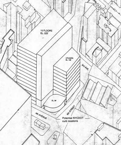
Community Calls for Rethinking Cooper Union's Massive Building Plans
Shown above is one option for massing new structures at Astor Place proposed by Cooper Union. The school would replace its Engineering Building with a large commercial building that would block traditional views in this historic area. Enhancing this space would be VCTC's plan for an auto-free St. Marks Place with a river-to-river crosstown trolley line.
Not surprisingly the prospect of three massive buildings in an area that is now fairly open has raised the ire of nearby residents. To offset this visual loss Cooper Union has suggested advancing a long standing proposal to close the eastern half of Fourth Avenue to motor vehicular traffic as its passes along the Foundation Building and remake it into a public park or promenade. Some nearby residents have greeted this proposal with alarm, citing concerns about traffic, reinforced with fears that new public open space may not be well maintained or properly policed. These concerns led to the elaborate fencing of the triangular park recently created at Ninth Street and Third Avenue -- a garden to be viewed but not visited. Residents living along Washington Place just east of Washington Square Park in the early 1990s raised similar concerns, when that lightly trafficked street was temporarily converted into neighborhood open space.
Clearly needed is a comprehensive plan that allows Cooper Union to transfer its unique tax abatement rights to other sites that are more suitable for development. One possible site, already owned by Cooper Union, is the Bowery Bar at Fourth Street. The parking, lot just east of the Con Ed building at 14th Street and Third Avenue, is another possibility.
Plans to convert street space to pedestrian space could benefit from a more comprehensive view as well. The sidewalk along the west side of Cooper Union's Foundation Building is little used. There is no entrance to the building along this walkway. This wide street, Fourth Avenue, links the Bowery to Park Avenue South at 14th Street. This roadway would be better used as a north-south traffic artery, with Broadway through NoHo and SoHo, which is lined with busy shops and crowded with pedestrians, released for an auto-free promenade. Broadway could also host a light rail line, running from the Battery to 23rd Street, and continuing north along Madison Avenue to the Harlem River. Portions of Lafayette Street could also be pedestrianized, particularly at Astor Place, where traffic must maneuver past pedestrians exiting the subway.
Replacing the Fifth Avenue buses with a Broadway/Madison Avenue light rail line opens the way for eliminating the extensive and environmentally unattractive bus layover areas around the Astor Place Station. Because of their much higher operating efficiency modern low-floor, high capacity articulated light rail vehicles could run the full length of Manhattan, instead of short turning some trips at Astor Place. The greater reliability and higher overall speed would mean fewer vehicles will be needed, and bunching can be avoided. Two-way transit service on evenings and weekends in this corridor would be a welcome change from the minimal northbound service now offered.
Finally, St. Marks Place is clearly the major east-west pedestrian street in the East Village. This is the street that needs pedestrianization. With its crosstown transit element converted to light rail a dramatic new urban space can be created in what is now a derelict set of traffic islands. Cooper Union's Foundation Building was once surrounded by street railway trackage. With VCTC's crosstown trolley put into place, the north entrance to this historic structure will once again face a street railway, an industry that helped Cooper Union's founder produce the fortune that led to its establishment.
By George Haikalis
Light rail transit will soon return to Minneapolis nearly a half-century after the last streetcars ran between the Twin Cities. Ground was broken early last year on the 11.6 mile, $675 million Hiawatha Line connecting Downtown Minneapolis with the airport and Bloomington's "Mall of America", perhaps the world's largest shopping center. Not unlike our proposed Village Crosstown Trolley, the new line will operate at grade on surface streets for about two miles of street in downtown Minneapolis. It will then follow a disused rail freight line that forms the heart of the Hiawatha Corridor.
Minnesota highway builders eyed this rail line for a key freeway link some fifty years ago, demolishing many homes in the corridor to permit an eight-lane highway. In 1985, after years of community opposition, public officials reached a compromise -- a four lane surface highway would be built with space reserved for a two track light rail line. Ironically, that was the same year New York State officials dropped their plans for the costly and disruptive Westway along the Hudson River waterfront, after a long and bloody battle led by a coalition of community leaders. Neighborhood activists in Minneapolis led the battle against the highway and in favor of the light rail line.
But it took 16 years more before construction began on the Hiawatha highway and light rail line. Many of the original opponents had long departed and it took an aggressive campaign by transit planners to gain support of new neighbors and fine-tune the plan. One stumbling block was the need to widen the narrow rail right of way to accommodate the combined roadway and transit line as it passed through Minnehaha Park on the west bank of the Mississippi River. Six large oak trees were staunchly defended by park activists who slept in hammocks in the trees to prevent their destruction. Ultimately the trees were felled, after a compromise was reached replacing lost park land with a 600 foot long tunnel. Another key outreach effort was to involve the community in the detailed design of stations so that there was a local pride of ownership of the project, rather than establishing a uniform system-wide design. For the downtown stations business leaders and employees were given an opportunity for input in the design.
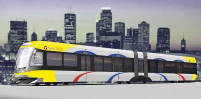
Illustration courtesy of Metro Transit
Minneapolis Light Rail Vehicles will soon link airport with Downtown
After 30 years of advocacy by community and business leaders Minneapolis' 26 new light rail vehicles, shown above in this photomontage, will soon link the airport and downtown. The vehicles are similar to those used on the Hudson-Bergen light rail line, operating only one mile across the Hudson River from the western terminal of VCTC's river-to-river crosstown trolley proposal. Minneapolis' LRVs are 70% low floor, making it easy for older persons, wheelchair users and parents with strollers to board.
Considerable impetus for this project came from the Downtown Council, an influential group of business leaders, who saw the need to introduce rail transit to maintain economic activities in the core. This interest was reinforced by regional planners who saw the continuing spread of suburban development as a worrisome trend. Unlike in New York, the Twin Cities has a very strong regional governmental planning entity that can deal coherently with future trends. With a half million new residents expected in the metropolitan area in the next twenty years-a twenty per cent gain-and with existing highways congested and expansion costly and disruptive, planners favored "smart growth" with infill housing and more concentrated commercial development. The new light rail line, and a new commuter rail line that is also planned for the area, would reinforce this desired land use pattern.
Only one block of 5th Street will be auto-free, the street segment between City Hall and the County Building. Closing this block will transform the remaining blocks from a heavily trafficked arterial into local service streets with only a single lane for access to a few parking garages. Making the block in front of City Hall auto-free was not easy, since members of the City Council found it convenient to park there. Now they will have to park in a nearby deck, a short walk away. (This certainly could be lesson for New York's elected officials.) Utility companies fought the 5th Street alignment, one of the main utility corridors downtown. Under city and state laws these companies were responsible for relocating lines if that was required to serve the public interest. A compromise was negotiated.
A mixed blessing for downtown workers and shoppers is the network of elevated skyways that were built somewhat at random over the past thirty years, to link many of the buildings in the core. On the positive side many downtown workers are able to move between buildings in Minneapolis' harsh winters without an overcoat. While for many of the newer structures the Skyways are an attractive component of the access system, the retrofit of older structures has been less successful. A strong negative is the diversion of pedestrians from sidewalks diminishing street life. The arrival of the new light rail line will reverse this trend.
Most of the stations on the Hiawatha line will be intermodal hubs. Some 46 Metro transit bus routes will connect at thirteen stations, many with timed transfers. At the Twin Cities International Airport station air/rail connections will be possible. To make this connection convenient, transit planners called for a 1.6 mile tunnel to reach terminal buildings. This was by far the most costly segment of the new line. Unlike new light rail lines extending to the airports in St. Louis, Baltimore and Portland, the Minneapolis light rail line continues past the airport to its terminus at the Mall of America. In addition to reaching thousands of parking spaces at the mall, the line interfaces with suburban bus routes serving the southern portion of the metro area. At intermediate stations along the line, little parking is provided. Instead, many of these stations will serve as catalysts for development, as part of the Twin Cities "smart growth" program.
The Hiawatha line will soon be operating with 26 new 94-foot long low-floor light rail vehicles each capable of carrying 187 passengers. The cars will be painted a bright red and orange, reminiscent of the old Milwaukee Railroad Hiawatha streamliners, and will provide a welcome contrast to Minnesota's bleak, snowy winters.
In New York, light rail transit can make an important contribution to improving the city's livability and economic vitality, while taming its out-of-control motor vehicular traffic. If Minneapolis, which is far less densely developed, can resuscitate its once extensive street railway system, then transit-dependent New York City can do even better.
The Tracks of New York - No. 1, Metropolitan Street Railway - 1907
Letter From the Editor
Dear Reader,
The events of 9/11 have led NYC's transportation officials to rethink their long standing commitment to unregulated auto access to Manhattan. We wish "MetroCard" Mayor Bloomberg complete success in turning around this municipal car-culture among his senior officials. With fewer cars coming into the core of our city the opportunity exists to reuse urban street space for pedestrian amenities and light rail transit. As we point out in this issue, Minneapolis provides us an excellent example of how to do this and Cooper Union's outsized development plans offer us a golden opportunity to move away from auto-dominated urban space.
Michael Goodman, Editor
NY Today
TimeOut New York
CitySearch New York
