Making Tracks Through Cyberspace

Village Crosstown Trolley Coalition
Making Tracks through the Village.Greenwich Village, New York City
Become a Member
Contact VCTC
The 8th St. Corridor
GV Transit
Newsletter
Questionnaire
Board of Directors
Volunteers Wanted
Calendar of Events
Transit Links
MAKING TRACKS - Vol. 5, No. 3 - Summer 1999
Entire contents of MAKING TRACKS is copyright © 1999 by Village Crosstown Trolley Coalition,
but may be reproduced either in whole or in part with a clear acknowledgment of the source.
Please report any errors to us at VCTC. Thanks.
Inside this Issue
A Grand Transit Improvement for the Lower East Side
MTA's Avenue D Light Rail Plan: A Plus for Village Crosstown Trolley
Second Avenue Light Rail Study Completed
Hudson-Bergen Light Rail under construction in New Jersey
Crosstown Trolley featured in East Village "Walk and Talk" Program
Letter to the Editor
Letter from the Editor
By William K. Guild
For nearly five years now VCTC has been urging the restoration of streetcars, or light rail vehicles, on the 8th St. corridor, in part to fill the deplorable transit vacuum in the East Village. Since long before that name was coined, when the district was just another undifferentiated part of the Lower East Side, the entire area has been short-changed on transit and the situation grew worse with the destruction of the elevated lines and the street railway system. The Village Crosstown Trolley would vastly improve the situation along the northern edge of this neglected area. A light rail transit route along the former Grand St. line could work wonders further downtown.
Like 8th St., Grand St. formerly had a busy river-to-river crosstown streetcar. From the Williamsburg ferries at the East River, the tracks ran west on Grand and turned south on Sullivan St., passing the site of present-day Juan Pablo Duarte Square, a triangular sliver park on the west side of 6th Ave. At Canal St. the line turned west again on Vestry St. before reaching the Pennsylvania Railroad ferries at the foot of Desbrosses St. Converted to buses in 1932, the route actually survived, in truncated form, until 1988, when the downward spiral of service cutbacks and reduced ridership finally led to total abandonment.
Increased traffic on Canal St. and the Holland Tunnel approaches may have had more to do with the demise of the Grand St. crosstown line than abandonment of the ferries in 1930. In fact, the Madison St. line, which ran from the East River at Grand St. to the Hudson River ferry slips at Chambers St., survives to this day as the M22 bus, running to the ferry landing in Battery Park City. Passing under the Manhattan Bridge en route to the Civic Center, the line avoids the terminal gridlock of Canal St., but does little for riders in need of crosstown transit at Grand St. It would serve little purpose to recreate the original Grand St. trolley line today, even if it were possible to cross Canal St. However, light rail across Grand St. from the FDR Drive to a terminal at Duarte Square just northwest of 6th Ave. and Canal St., would make a great deal of sense and serve a number of constituencies.
Like the 8th St. corridor, a surface transit line along Grand St. would intersect or provide an easy transfer to every major north-south subway trunk line entering Manhattan. The Grand St. subway station at Chrystie St., now served by the B, D and Q lines, will also become a stop on the 2nd Ave. subway if the southern section of that line goes forward (see accompanying story). Between Centre St. and Broadway, transfers would be available to all lines serving the three-station Canal St. subway complex, currently the East Side IRT (#6), J, N, R and Z. The proposed western terminus would be located directly between entrances to the IND (A, C and E) and West Side IRT (#1 and #9) Canal St. stations. And of course transfers would be available to all existing surface lines serving lower Manhattan.
Based upon the street grid, Grand St. extends to the easternmost point on Manhattan Island, Corlears Hook (see MAKING TRACKS, Fall 1997). Now providing the southern anchor for East River Park, this area was an early target of slum clearance and urban renewal projects and is now occupied mainly be high rise housing developments. Moving west, Grand St. crosses the famous Lower East Side retail area and then a fast-growing arm of Chinatown, before passing through the heart of Little Italy. Skirting the former Police Headquarters, now converted to luxury residences, Grand St. goes through a largely commercial area near Broadway before entering Soho, with its upscale shops, galleries, lofts and the Soho Grand Hotel. To the west, the proposed light rail line would terminate among the giant commercial, factory and loft buildings of Varick St, Canal St. and 6th Avenue.
Thus the Grand St. light rail line would link together and serve a remarkably broad variety of business and residential communities cutting across both the ethnic and the economic spectra. Its primary role would be to provide transit access to residential communities long cut off from the main stream of New York life. Like the 8th St. line to the north, however, it would also move residents and visitors alike to and among a wide variety of existing commercial retail and tourist attractions.
The character of Grand St. may be even more varied than that of the 8th St. corridor and the width, both of current roadways and between building lines, differs significantly from place to place. VCTC has not made a detailed survey or study of the various segments. As with 8th St., however, we would urge that some portions of the route be substantially auto-free, particularly in areas attracting large numbers of pedestrians. In addition to drawing more shoppers, tourists and other visitors to historic and commercial segments, light rail will reduce the need for residents to maintain and use automobiles just to reach the outside world.
One major objective of the great subway building boom beginning a century ago was to disburse the masses of residents on the Lower East Side, then the most densely populated area on the face of the Earth. To achieve this goal, a uniform transit fare was established for trips throughout the city, regardless of distance traveled. These measures succeeded admirably, as upper Manhattan, the Bronx, Brooklyn and, eventually, Queens became bedroom communities for hundreds of thousands employed in the central business district. Ironically, the Lower East Side itself was largely overlooked. As we have seen, the area was better served by transit in the age of elevated and street railways than it is today.
Elsewhere in this issue the pros and cons of specific transit improvement proposals for the East Village and Lower East Side are discussed and evaluated in detail. Planning such improvements so that they will complement one another and produce a coherent, unified system is of paramount importance. Reconversion of the 8th St. corridor from buses to light rail, and re-establishing crosstown transit in Grand St., should be key elements in such a system for the 21st Century.
By George Haikalis
Who could be against building the Second Avenue Subway? Since the closure of the elevated railways of Second and Third Avenues a half century ago Manhattan's densely developed East Side has been served by only a single, chronically overcrowded subway-the Lexington Avenue line. Getting to this subway is quite a chore for many East Side residents who must walk a half-mile or more. From the East Village and Lower East Side the walk is even longer, particularly when compared to the walk to the old Second Avenue el which actually jogged over to First Avenue south of 23rd St. But the much sought after Second Avenue Subway has remained a dream. Proposed in the late twenties, and again in the late 40s, construction actually began on the Second Avenue subway when it became part of the MTA's grand plan adopted in 1968. In the 1970s scarce transit funds allocated for new projects, including the Second Avenue subway, were diverted to pay for much-needed restoration of the city's subway and bus system.
However, the need for additions to the region's basic transit network remains, and in the early 1990s MTA launched a half-dozen studies of long proposed links. One of these, the Manhattan East Side Alternatives (MESA) study, looked at the Second Avenue subway and its alternatives. The release of the long-awaited MESA final report in August ignited a great debate about how much of the subway should be completed, and who will pay for it. Many of the options under consideration affect the East Village and it seems appropriate for supporters of the Village Crosstown Trolley to weigh in on these issues.
To keep the project affordable, the MTA proposed initially building only the northern three miles of the subway from 63rd St. to 125th St. Instead of a subway from Union Square to Whitehall St., the MTA proposed a 4.5 mile long light rail line along 14th St., Avenue D and Water St. Community activists, led by the Regional Plan Association (RPA) have argued for building a subway the full length of Manhattan, and including links to the Bronx, Queens and Brooklyn. Metro-Link, RPA's plan, would also include a subway branch under Avenue C in the East Village and the Lower East Side. RPA estimates its plan would require some 14 billion dollars for about 14 miles of new subway. The MTA claims its MESA plan would come to about five billion dollars.
VCTC supports the MESA Avenue D light rail plan. This would greatly improve access for the transit-starved East Village and Lower East Side. It represents the first real MTA initiative for light rail transit, and would help strengthen the case for VCTC's 8th St. crosstown trolley proposal. Of course, a Second Avenue subway operating the full length of Manhattan remains a long-term goal. In Manhattan, light rail can serve a useful role augmenting the North-South trunk line subway routes by providing efficient east-west crosstown distribution. In this issue of MAKING TRACKS, VCTC suggests another crosstown light rail line to serve the Lower East Side-on Grand St.
A useful precursor to the Second Avenue subway would be a light rail line operating in a pedestrianized Second Avenue, proposed by the Committee for Better Transit (CBT) and the Institute for Rational Urban Mobility, Inc. (IRUM). This would be especially helpful for short distance trips and would vastly improve mobility over the current bus system. For people with walking and stair climbing difficulties, modern low-floor LRT vehicles provide an attractive alternative to subways or conventional bus service.
Community leaders and elected officials would be wise not to dismiss the Avenue D LRT proposal too quickly in favor of a far more costly, and potentially less useful Avenue C subway line. This line, as described in RPA's Metro-Link plan, would not provide direct access to Lower Manhattan and would require multiple transfers to reach most Midtown destinations. The MESA light rail proposal has considerable standing, having completed two key Federal requirements for funding-the Draft Environmental Impact Statement (DEIS) and the financial hurdles of the Major Investment Study (MIS) process. While the surface light rail plan would be a modest inconvenience to a few motorists it would be a great help to most residents in an area far removed from existing subway service.
Several refinements to the MESA LRT proposal are worth considering. Instead of terminating at Union Square, the 14th St. segment could continue west to Tenth Avenue and the new Hudson River Park, allowing the LRT to fully replace the 14th St. crosstown bus. The MTA should add more stops along the route providing better local access, without greatly reducing overall speed. A more direct route from Avenue D to Water St. would avoid the costly tunnel connections to the Chambers St. subway station, proposed in the MESA study. Almost half of the basic capital cost of the MESA LRT proposal is tied up in these connections. Instead of bypassing Chinatown, the new LRT line could serve the very heart of this busy area in a pedestrianized East Broadway. This would be a great boost for residents and tourists.
As long as community and political leaders press for costly new subways over surface light rail transit-in order to preserve space for motor vehicles in Manhattan-New York City's quality of life will suffer. Leaders need to lift their heads out of the sands of the 1930s, with its cars-first mentality championed by Robert Moses, and look no farther than across the Hudson River to Exchange Place in Jersey City where new surface light rail tracks are now under construction (see photo on this page). Jersey City's booming waterfront financial district is focused on this new light rail development. Light rail transit can play an important role in economic development in NYC as well. While not a substitute for new express subway lines, LRT can augment the existing subway and commuter rail network in a cost-effective and community-friendly manner.
The MTA is also looking at a number of other rail additions. Its LIRR access to Grand Central Terminal would utilize a 1.6 mile tunnel built under the East River at 63rd St. over twenty years ago. Its Lower Manhattan Study is considering extending Metro-North trackage south from Grand Central in a deep tunnel to Wall St. and on to Brooklyn connecting with the LIRR at Flatbush Terminal. A third study, jointly conducted by MTA, NJ Transit and the Port Authority, is considering a new tunnel under the Hudson River with a link from Penn Station to Grand Central. Another study is quietly examining direct one-seat ride rail options linking Manhattan to the on-airport AirTrain system now under construction at Kennedy Airport.
These individual rail proposals are loosely packaged in Governor Pataki's "Master Links" plan. Not to be outdone, Mayor Guiliani has proposed his own rail additions including a new rail line to LaGaurdia Airport and an extension of the Flushing (#7) Line (instead of the 42nd St. LRT) to a new football stadium on the West Side of Manhattan. The Mayor has signed on to a study of a cross-harbor rail freight tunnel, long a dream of Congressman Nadler.
In the meantime MTA should take immediate steps to reduce overcrowding on the Lexington Line. Some of the riders on express trains from the Bronx could be diverted to Metro-North by cutting fares and increasing service. Others could be shifted to the subway under Central Park West (A and D express) which could accommodate a third Bronx Express service. Streamlining the unnecessarily complex plan for LIRR connections to Grand Central Terminal could cut costs by two thirds and implementation time in half. Quickly adding more track capacity under the East River would permit Metro-North to operate trains from Co-op City and the East Bronx to Penn Station by way of the Hell Gate Bridge, further diverting riders from the Lexington Subway. A less costly Grand Central connection would free up funds for other transit proposals.
Clearly simultaneous funding for all these projects is not possible. Furthermore putting this collection of ad hoc proposals into a coherent regional rail plan remains to be done. While VCTC commends the earnest renewed interest in long overdue rail investment plans by MTA and political leaders, the need for a cost-effective, doable rail expansion strategy remains. And except for the MTA's Avenue D LRT plan, proposals that encompass expansion of pedestrian space and significant improvements to surface transit are absent from the discussion.
Second Avenue Light Rail Study Completed
The 180 page study, with numerous color illustrations, is available through VCTC for $15 postage paid. Send checks, made out to IRUM, to our address shown on the back of MAKING TRACKS.
Hudson-Bergen Light Rail
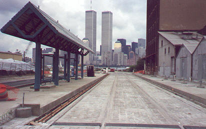
- Michael Goodman
Hudson-Bergen Light Rail under construction in New Jersey. Here is a station, with platforms on either side of the two tracks, under construction just across the river, in the shadow of the World Trade Center towers. Notice how close to the level of the rails the platforms are. Low-floor light rail vehicles will be used on this line allowing for easy on/easy off by all passengers. It is scheduled to begin operations in April, 2000.
Crosstown Trolley featured in East Village "Walk and Talk" Program
VCTC President George Haikalis and Treasurer William K. Guild will lead a walking tour of the Coalition's proposed crosstown trolley in the East Village on Saturday, October 23, 1999, beginning at 2 pm (meet at the Parks Department building at 9th St. and Avenue A). The walk is part of the 2nd Annual "In and About Tompkins Square Park: Walks and Talks" sponsored by the East Village Parks Conservancy. The trolley tour will retrace the route of the original 8th St. crosstown trolley that followed St. Marks Place, Avenue A and East 10th St. through the East Village as it made its way across town from river to river. Four other strolling talks are scheduled. VCTC will also show its "Streetcars and the Streetscape" slide show at the Tompkins Square Park Branch of the NY Public Library on 10th St. at 12 Noon as part of the program.
Letter To the Editor
Dear Making Tracks:
My compliments on another fine issue. "Mulling over Mulberry Mall" by George Haikalis [MAKING TRACKS, Spring 1999] offered a good insight into the benefits of pedestrian only streets in lower Manhattan. Alas, one big difference between NYC and leading European cities is the amazing deference paid to the tiny minority of community residents who oppose car-free streets. 80% of the households in Manhattan south of 14th street do not own a car. Additionally, the vast bulk of visitors to the area arrive by public transit. Let's hope that the success on Mulberry Street translates into more car-free streets. George's suggestion of a car-free St. Marks Place is a good one, other streets like Washington Place and 4th Ave. at Cooper Square are also good opportunities for pedestrianization. Keep plugging away, the trolley will yet have its day again in New York City.
Sincerely,
John Kaehny
The writer is the Executive Director of Transportation Alternatives.
Letter From the Editor
Dear Reader,
The Second Avenue subway is the talk of the town now that the MTA has finally presented its ambitious capital plan, which includes a variety of rail expansion proposals. Unfortunately, its proposals for mass-transit improvements--including the 2nd Ave. subway--fall short of a coherent, comprehensive plan. This issue discusses the MTA plan, specifically the Avenue D light rail proposal-the agency's first recommendation for light rail transit in NYC. Also in this issue is an article proposing a light rail line on Grand St., complementing the 8th St. crosstown light rail transit line advocated by VCTC. Planning transit improvements which will complement one another and produce a coherent, unified system must become a top priority for NYC and the region.
Michael Goodman, Editor
NY Today
TimeOut New York
CitySearch New York
