 Disclaimer: The Broadmoor, amongst others, claim to own Cheyenne Mountain pretty much outright, and lots of silly laws say that certain people have private property rights in the area I'm going to discuss. If you don't want your car towed, for example, tell the proprietors at May's that you're leaving a vehicle there for the day or it might not be there when you get back. Other than that, escape and evade the Broadmoor employees (they'll call the sheriff, for what good it'll do them, as will residents living along the radio tower road) to your heart's content. The views are worth the risk and there used to be free access along the road and several trails to these points, but I cannot advocate breaking the law. All decisions made by other parties attempting this are there own and I have no responsibility in them. That said, nobody 'owns' the mountains, no matter what our silly government says. Oh, and NORAD (Cheyenne Mountain Air Station), they'll shoot you if you trespass, so I don't recommend heading down or across that way. Just a friendly warning. Oh, and if anyone wants to prosecute, I'll just say that this story is conjecture and I found the pictures laying around online.
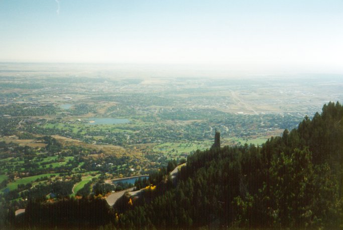 So why would I write about this non-adventure (in the context of others that I've had)? Well, It's an interesting place with lots of history. Not many people remember and almost no one but they even know of the existence of a fancy restaurant once perched high atop Cheyenne Mountain's north summit, above the Horns, long long ago. I believe (not enough research data available at this time) that it was open in the 30s, 40s, and early 50s, and the few net sources I've found (older people asking if anyone else remembers it, mostly) don't get very specific. It's demise is mostly rumor, as well. But follow along, and I'll relate what I can tell you. If you know more or know someone who does, please let me know!
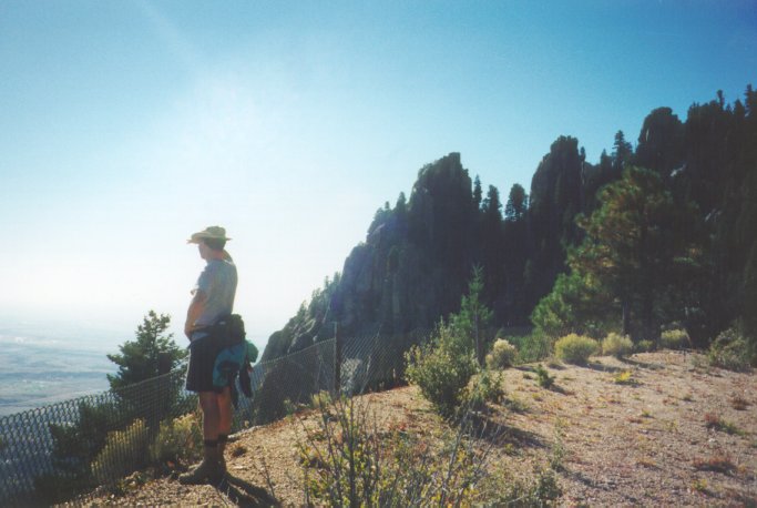 I climbed the mountain for the first time while I was in the army, looking for something interesting to treat my soldiers to for 'adventure training.' Cheyenne Mountain is right above Fort Carson and dominates the western skyline from anywhere on main post. Cheyenne Mountain Air Station (CMAS), commonly known as NORAD, is located on the lower southeastern flanks of the mountain, with the command center located 1300 feet inside. That's another complete story, since they no longer offer tours to the general public or even to the military community. If you were lucky enough to visit the hole, consider yourself in a small in-the-know minority, and congratulations. It's a pretty interesting place.
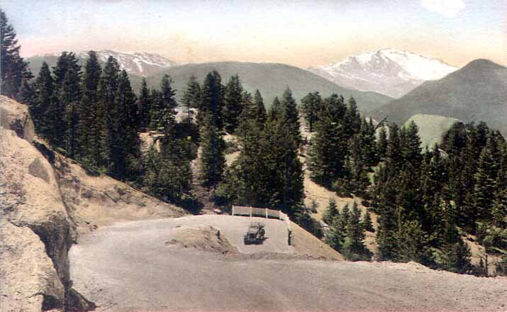
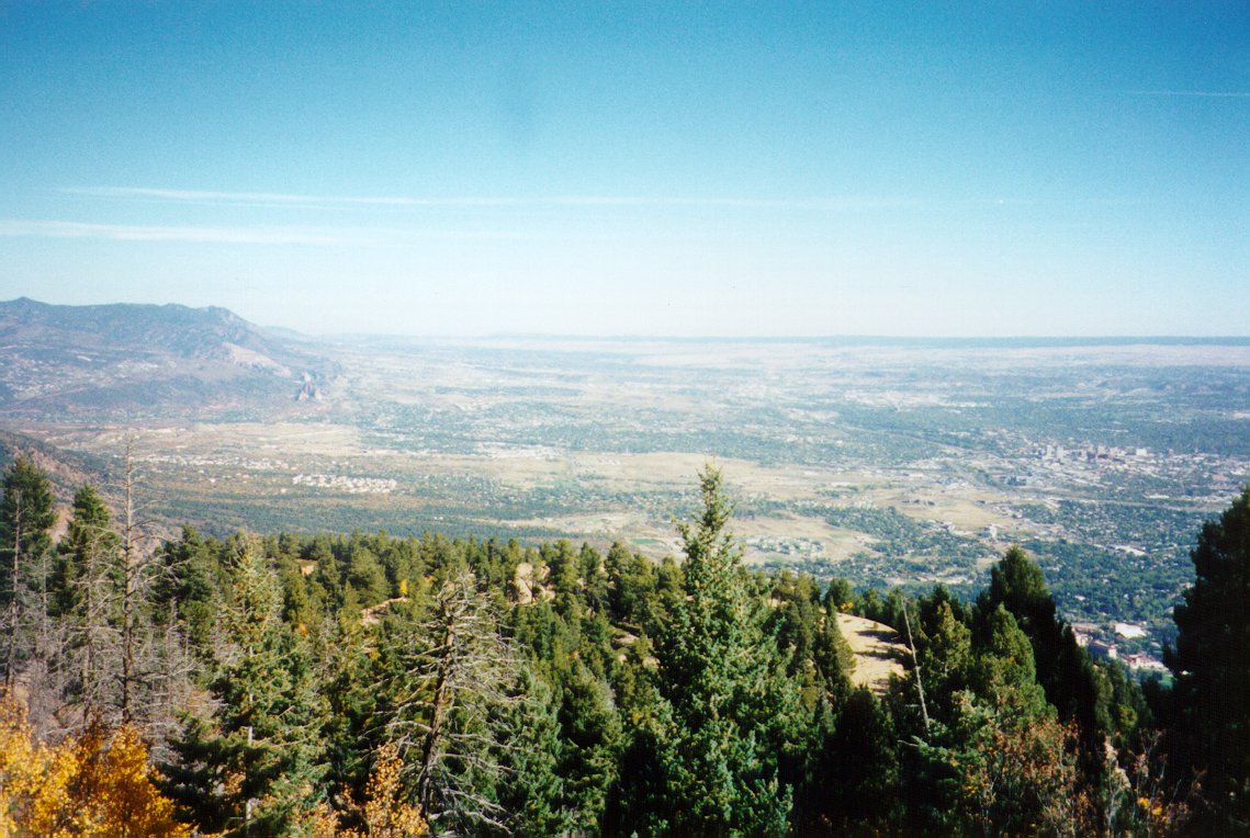 The road up is dotted with private (mostly summer) residences, and word is that they'll call the sheriff in to report trespassers. No one was there when we went hiking, about 1 in the afternoon. The road is easy and graded, and winds up and around the south side of the mountain for several miles. Eventually, you get to the gate that the owners of all the radio transmission towers have keys to, but no one else. I don't think it's technically private property beyond that point, but I'm not sure. We hopped the gate and continued walking on the road. It never gets steep, but there are lots of switchbacks before you getto the top.
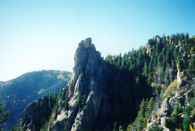 Up on top, there is a large collection of towers from different radio and television stations, plus the local amateur radio club, and a microwave relay station. The old (massive) waveguides for the microwave relay were taken down and placed at the bottom of the tower and replaced with modern smaller guides sometime back; they're interesting to see, too. Once you're at the main loop up top there are signs warning of intense radiation hazard all over, so it's not a good idea to stay really close to any towers for more than a brief walk by.
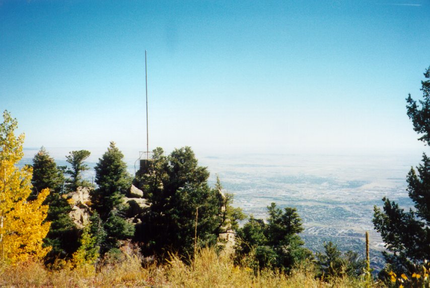 Not much to see on this summit, really. We scouted it out and determined such, although the view would have been great if it hadn't been cloudy. Our recon led us back down, looking for the drainage to Rock Creek, which would take us to our escape vehicle. Without a map, it's impossible to determine which gully down to take without hitting cliff bands. I'll get on to the escape route details later, but needless to say we took a full six hours to get up and down the nasty backcountry terrain, bushwhacking and crawling around big dropoffs.
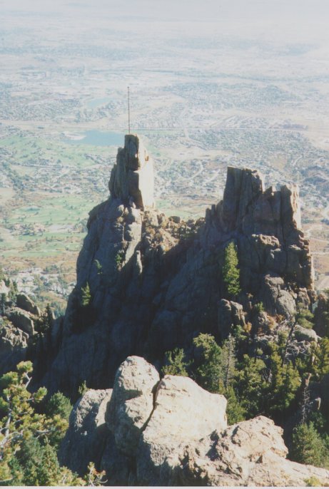
 Since we'd already gone that far, we decided to keep walking up to the top. The road is severely degraded and probably only passable on foot or mountain bike now, with several cuts having collapsed onto the roadway. Another hour of walking (it's a short distance straight-line, but with plenty of switchbacks to keep the grade down) past old picnic areas and relics, like an old ore-car bridge most likely used in the construction (I understand a cable car was used to haul up some materials, though we saw no signs of it), brought us to the parking lot for the old restaurant.
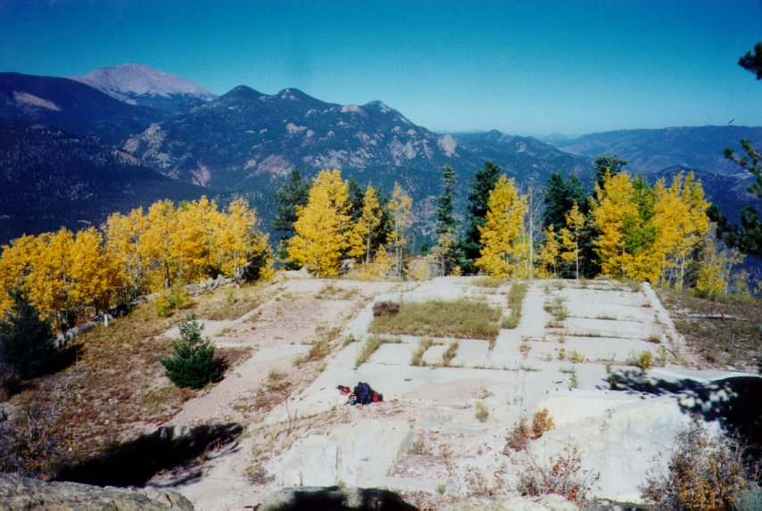
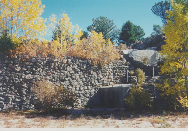 More pictures in a minute. We explored on top for a while, finding the old foundation with the remains of the restaurant, apparently pushed off the top by vandals in the 60s (and the work finished by dozers for safety), and climbed to the telegraph/signal station on the north summit in light snow. A little further south, towards the saddle, the peak drops off about 30 feet in cliffs, and we weren't about to attempt those in snow without a rope, particularly with my previous experience descending Rock Creek. So, we descended the old road, and when we could see the main gully leading due north to where Old Stage turns from pavement to dirt, went straight down. 45 minutes of bushwhacking down and another 30 minute walk on the streets back to the zoo took us to the car.
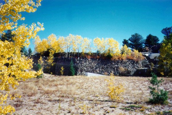 And then yet again, my last time on top (so far), with thoughts of crossing the saddle and making a complete loop; we thought of looking for the wreck of the old bomber that hit the mountain during a training flight early in WWII, but discovered from research that the wreckage had all been removed years before. I went over the top (properly prepared, with lots of food, water, clothing, and a rope) with an AF captain I knew teaching at the Academy. As with the previous time, the weather was absolutely beautiful. Drawing on previous experience, we left a car at May's and started our hike up the Old Stage transistion gully. The hike up is miserable, loose, disintegrated Pikes Peak granite, which becomes almost a sand of small (1/8th inch) gravel where the slope is too steep to support trees or grass to hold it together. After an hour, we reached the road, just below where the old trail from Old Stage comes in (this is where the water piping goes straight up the hill, maybe a mile past the transistion to dirt on the road, and now on private property with someone's cottage next to it; look hard when driving up the road and you'll see it).
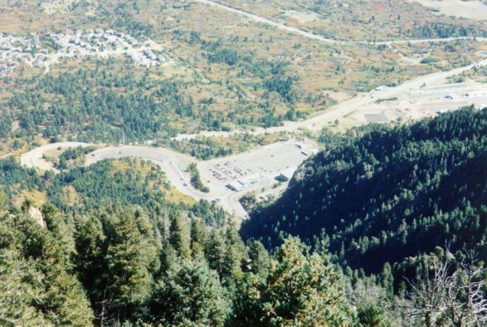 Our trip up the road was unexciting but the views were stupendous. We explored much more thoroughly the turnouts for the old plows and restaurant/road service vehicles, and the rusting wreckage left around these areas, before making it to the top. There's an old flagpole on top of the horns, and another evidently used more commonly at a main mast nest to the restaurant foundation. The foundation has several lookout areas with deteriorating stairs, and what was evidently the kitchen and pantry or a garbage area, built around it. Way up on the summit, at the terminus of the water piping and where the signal station (the only remaining structure, good for waiting in during inclement weather), are graffiti marks from other groups who've explored the summit. I don't like leaving a trace, so we took the pen with us and hopefully the place will stay like it is for a long time.
 We took our pictures and continued on, knowing how long the road ahead was. The route over the saddle to the radio towers and south summit wasn't nearly as treacherous as it had appeared two years before, in the snow, and we descended 4th class rock and traversed 60 degree forest slopes to reach the saddle. There are no trails, but going up the other side by the path of least resistance eventually led us to the meadows just north of the radio towers and microwave relay waveguides. The view from the the gully most directly above NORAD's main entrance is only instructive if you know how the facility is constructed; the photo here shows the parking lots, main administration building, and a small bus terminal (look closely and you can see the bus) just outside where the road disappears into the mountain.
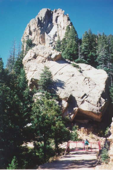 The path down Rock Creek took us another 3 hours to negotiate. You descend steep narrow gorges where runoff from rains and snowmelt have left no room to maneuver except through thickets, cross the creek in the main drainage about 30 times, usually by walking through where it seems widest and slowest, and crawl along steep dirt ridgelines where the drainage becomes vertical. There are several waterfalls
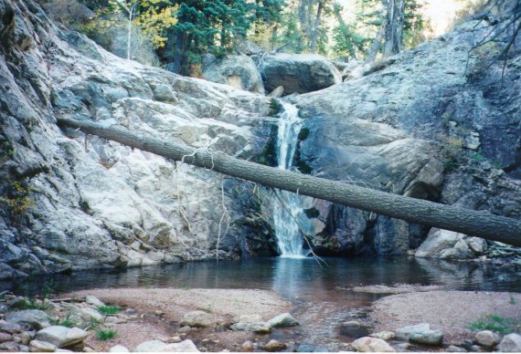 that must be bypassed on the south, and one where the stream has cut a path through a hundred foot rock dome (that one can be descended directly). Many houses are located at the end of the private road past May's, and you have to walk on the access road past them to get out. We haven't been yelled at for walking down the road yet (all of the no trespassing signs face the other way, going up), and the small gate at the bottom, usually closed, should be closed when you go through it to keep their animals and small children inside. May's did yell at us for parking in their lot, which appears to be the right-of-way, but they indicated that they wouldn't have a problem with parking there if permission was asked for.
Mountaineer Home
Aconcagua98
Resume
Ski Pikes Peak
Impact Events
4x4ing Colorado
My Thesis Online