|
|||||||||||||
The total surface area of Argentina (not including the Antarctic claim),is as the following:
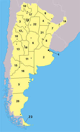
Argentina is nearly 5,121 km (about 3,182 mi) long from north to south, and 1,400 km (about 870 mi) from east to west (maximum values). It can roughly be divided into four parts: the fertile plains of the Pampas in the center of the country, the source of Argentina's agricultural wealth; the flat to rolling, oil-rich plateau of Patagonia in the southern half down to Tierra del Fuego ; the subtropical flats of the Gran Chaco in the north, and the rugged Andes mountain range along the western border with Chile . The highest point above sea level in Argentina is located in Mendoza . Cerro Aconcagua , at 6,962 meters (22,834 feet ), is the highest mountain in the Americas , the Southern , and Western Hemisphere . The lowest point is Laguna del Carbón in Santa Cruz , -105 meters (-344 ft) below sea level. This is also the lowest point on the South American continent . The geographic center of the country is located in south-central La Pampa province. The country has a territorial claim over a portion of Antarctica (unrecognized by any other country), where, from 1904, it has maintained a constant presence .
|