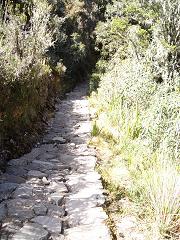
We spent the rest of the day descending on a continuation of said rugged steps to our campsite (still above the frostline). The clear night and high altitude dropped the temperature to -5 (Degrees Celcius). Neither of us noticed the cold though as we were too busy sleeping the sleep of the dead after our strenuous day. The following day included a tour of three impressive Inca Sites and a descent of over 1400 steps. The pace of our group of 17 was varied and we spent much of our time wandering through heavily treed areas alone together. It was a maginificent day and when we broke for lunch one of our guides pointed out the backside of Machu Picchu. It left us feeling a sense of awe. We were very aware of the many microsystems that make up the Inca Trail. Each time we turned a corner, it seemed as though we were in a different place in the continent. Early on in the day we were canopied by lush, jungle like vines and trees. At lunch we ate on top of an arid, hot, desert-like peak. Our final descent was like walking through a pine forest and we had to be careful not to slip on the needles that covered the ground.
When we arrived at camp that night we were told that we would be woken at 3:30 am. Our guias (guides) wanted to be first through the gates and first to explore Machu Picchu's glory. As it turns out we were second through the gate. As we were waiting for the check point to open, Shelley spotted a scorpion at her feet. Several other people in our group had encounters with Tarantulas and we had been told that snakes often found their way into tents. Needless to say, we were vigilant about checking our sleeping bags before crawling into them.
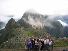
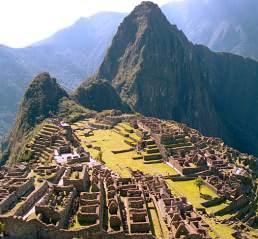
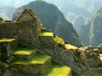
We hiked about two hours through the dark until we arrived at the Sun Gate. Usually, your first site of Machu Picchu, but on this day it was shrouded in fog. We hiked on for another hour or so and arrived at the bluff over looking Machu Picchu. It was truly amazing, much like the post cards we had seen prior to our departure, only more picturesque. We stood for several minutes, silent, breath held, eyes fixed in awe of the site before us. We spent the rest of the morning and part of the early afternoon exploring Machu Picchu. Each room was made with a purpose in mind and the windows, carvings and walls were all aligned to indicate either compass points or solar activity. We sat in a quiet corner of a well hidden room and took in our surroundings.
From Cuzco we travelled 9 hours by bus to Puno, our gateway to Lake Titikaka. Puno was familiar in an odd way. It resembled many of the economically depressed areas of Quito and was reputedly very unsafe for tourists to be walking the streets at night. While we were in Cuzco, we took a boat to the (floating) Uros Islands and Tequile Island. The several dozen floating islands that comprise Uros are made of reeds. Familes live a completely sustainable existence, growing potatoes, fishing, making reed canoes and selling handicrafts to passing tourist boats... This was a highlight for both of us and we tried to imagine how comfortable a sleep it would be to have a massive waterbed for a floor. The only problem we could see that existed on the island was a decent place to cook. The Islanders take large rocks and nestle them into the reeds. They then light a fire on said rock. The islands are stable, but there is a lot of give to them and they are completely made of organic material. Needless to say, cooking over an open flame would require patience and nerve.
After the Uros Islands, we arrived on and hiked around Tequile Island, the largest Island on the Peruvian side of Lake Titikaka. Tequile is a community that has existed for centuries and is steeped in tradition. On Tequile it is easy to discern which men are single and which men are married. The single men are eligible when they have knitted themselves a hat with a white top. The married men have knitted themselves a red hat and a back brace (using some of their wives' hair) and their wives a black shawl. Instead of asking a family for their blessing, a man wishing to marry has to present his beloved's parents with a bag of coca leaves. Hmmmm...
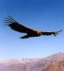
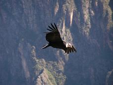
The situation in Bolivia (general strikes) would not permit anyone to cross the border (either way) and so we decided to remain in Peru. The following day we left for the Colca Canyon. The Colca Canyon is the deepest canyon in the world and has two attractions. First, are the Andean Condors. At close to 40 pounds and with a wing span of over 10 feet, the Andean Condor is (we think we heard) the largest animal capable of flight. Second are the thermal baths that are dotted throughout the Colca Valley. We drove for six hours from Puno to Chivay with a Spanish speaking guide who spoke very little other than to warn us, just before we reached it, that we would be reaching a maximum altitude of 5000 metres. It was one of the remotest places either of us had ever travelled and we saw a host of spectacular sites. Frozen waterfalls, thousands of piled rocks called wishing stones, rock corrals that were centuries old, tornadoes, and of course at every stop (no matter how remote) there were people there peddling handicrafts of all descriptions.
After spending a night in Chivay we drove into the canyon and witnessed a daily occurance. The condors' weight prohibits them from flapping their way out of their canyon home, so everyday between 9 Am and 10 Am the condors ride the warming air updrafts out of the canyon. They circle in ever increasing height until they have cleared the canyon walls. As they fly overhead, the wind pressure on their feathers causes an eery vibrating sound that fills the air. We were sad to see them vacate the canyon and disappear into the hills beyond.
Back