
Just North of Baker, California is Silver Lake, a fairly small dry lake
bed of cracked, baked mud. On the North edge of the lake bed, three sets
of power lines cross over the lake with a fairly well maintained dirt
access and maintenance road under the power lines. West of the lake lies
an archeological site: The Silver Lake Indian Rock Cairns consisting of
174 small piles of rocks contained within three fenced enclosures.
For a list of photographs of the area, check these
out however the detailed photographing of numbered rock piles has not
yet been posted to this web site.
To get there one stops in Baker, California which rests upon Highway 15,
the major highway which connects Southern California to Las Vegas,
Nevada. Behind the "Mad Greek" resturaunt you'll find Highway
127 which heads North to Shoshone. If you travel that road for 9.3 miles
you'll come to large power line towers and a large patch of open and
packed dirt on your left which followes along side of the power lines.
If you turn left to take that dirt road, you'll drive across the Northern
most tip of the dry lake bed and 4.6 miles later, you will come to the
archeological site. A small redish brown sign will mark the site and
give you a brief summation of what you're seeing.
Normally you would enter this topological drawing from the upper right
hand corner. After crossing the dry lake bed you would enter this
drawing North East of where I've marked it with the word "One."
If you continue on down toward point "Two" on this drawing
(sectors numbers 31 and 36) you'll get to the Indian rock piles. If you
turn right toward point "Three" along the better maintained
dirt road, you'll eventually get to a working mine where visitors are
usually not welcome (bring beer if you visit.) Heavy machines travel
along that road so that's why it's maintained very well. Along the power
line access road, though, vehicle traffic is very rare and most days no
vehicles at all will pass down that road while on rare days you might get
as much as two cars. From time to time a power company maintenance
vehicle will drive South of sector 31 in this drawing, do some work at
a large power facility, and then turn around and drive back toward
Highway 127.
All three sections are fenced in to keep humans and other animals out
of the site to keep them from destroying what's left of the rock cairns,
however humans do at times enter the fenced-in areas and they walk all
over the site leaving foot prints and litter. Every year my sons and I
police the site to picking up that litter and also to repair the fences
around all three sections.
To preserve the archeological site we've numbered and photographed
each of the cairns and have attempted to plot their positions within each
of the three fenced-in sections. These photographs will be
made available shortly on this web site however there was much difficulty
in getting the cairns' positions properly plotted due to the fact that
the power lines which pass right over all three sections make taking
compass headings rather inaccurate.
Sectioning off the site using a grid of numbered fishing lines to most
accurately locate each cairn would have required extensive time being
spent inside of each enclosure and so that couldn't be done given the
fragile nature of the site. (Even litter removal constitutes a measure
of risk. We find that people go in there and walk right on top of the
cairns, leaving foot prints, beer cans, tobacco filters, and even spent
ammunition cases all over the place some times. Picking up this litter
requires the wearing of special shoes which don't leave foot prints and
extreme caution to be sure not to disturb the site while cleaning it.)
Indeed, the electromagnetic emissions from the power lines even make
taking compass headings of the fences inaccurate. Getting an accurate
plot of the shape of each enclosure is difficult because getting accurate
compass headings is impossible. The electromagnetic emissions is most of
the problem however I find that the barbed wire of the fences are also
slightly magnetic which further complicates employing any compensation
plan based upon known degrees of needle deflection caused by the power
line emissions.
Any way the photographs of the first enclosure will be made available
shortly with or without plotted positions showing a diagram of where
each cairn rests.
Eventually -- once the cairns are properly and accurately plotted --
it is hoped that the position information can be cross checked against
star maps of visible stars to see if there is a reasonable match with
any known or historic constellations. That would give something of a
good idea into why these cairns were made if in fact they were intended
to represent an astrological / astronomical configuration.
That "trail" meets up with another trail and that one is very
old and dates back at least 100 years ago. It's very rarely used and
even then it's only used -- to my knowledge -- by various academics,
environmental agencies, the United States Geological Survey, and perhaps
history researchers. This road is not recommended for one or
two wheel drive vehicles! If you have a true four-wheel-drive
vehicle, you might survive taking this trail otherwise you can park along
the side of the power line access road and hike the trail.
The desert in that area retains the impression of vehicles passing over
it so you shouldn't mark up the desert anyway. If you drive along the
old trail, you can at least not add a blemish to the desert. The trail
is a better hike, anyway.
I mention this because if you plan on camping in the area over night, you
shouldn't park either on the dirt maintenance access road or on any of
the dirt spurs which give maintenance vehicles access to the towers.
Camping under the towers is tresspassing and also dangerous. The power
lines crackle, sputter and pop constantly and they radiate strong
electromagnetic fields which are powerful enough to illuminate four foot
long tube light bulbs and they're strong enough to induce currents along
human skin. While not exactly dangerous, you probably don't want to
sleep under the things for any period of time, anyway. Parking on the
dirt access road along the power lines at night could get you run over by
a power company truck.
If you explore the area immediately around the power line access and
maintenance road within a quarter of a mile of the Indian rock cairns,
you'll find that modern humans have created their own out in the desert,
often with wooden crosses to mark the burrial of pets. Awar from the
crackle and pop of the power lines, out in the endless vista of open
desert late at night, the moon shines down on an utterly silent basin
and it's a good place for the contemplation of things spiritual. The
Indians who lived in the area must surely have felt it a place of power
and modern humans seem to think so, too, and some come to intern their
pets out in the desert a short distance from where the Indians built
their rock cairns.

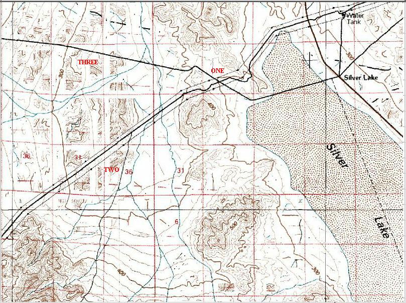
Click on the Topological Drawing to the left to
see a larger picture of the entire area. The dark line going from the
upper right hand corner of the drawing to the lower left hand corner is
the power line maintenance and access road -- a sandy dirt road in fairly
good condition -- and as you can probably see from the drawing, there are
three parallel sets of power lines running through the area. Towers are
indicated by dots which are connected by solid lines representing the
power lines. The dark line at the top of the drawing running from the
upper left hand corner to the upper right hand corner is another well
maintained dirt road. Indeed, that dirt road is very well maintained.
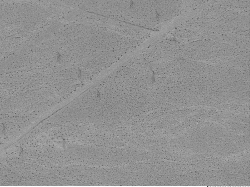
Click on the Air Photograph to the left to get
a better picture of the entire area from the air. You'll see four
towers in the center of this photograph. The tower almost right in the
very middle of the photograph is unfortunately located right in the
middle of the Indian cairns since the power company drove their road
right through the site (destroying an unknown number of rock piles while
doing so, unfortunately.) Across the dirt road from that tower is the
rest (and largest section) of the archeological site.
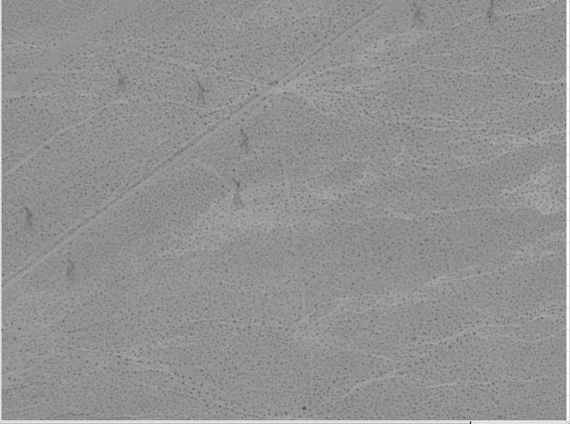
Click on the Off Road photograph to the left to
get a better picture of the road just North of the Indian rock cairn
site. You will have passed this section of the dirt road when driving in
and you may have noticed that there was a difficult to see dirt trail
leading off to your left about 200 yards North of the rock cairns. If
you take that "trail" you'll find yourself heading off into the
desert (and maybe off to your own death) toward the left of a small range
of mountains which rise perhaps 2,000 feet above the desert floor. It's
not a maintained trail or road by any means and in fact the trail will
just disappear entirely from time to time.
Back to the start of the Silver Lake Indian Rock Cairns web site