|
GILGIT
BALTISTAN
Gilgit and Baltistan are situated
in Pakistan� over which are strewn some of the world's highest
mountains-the Karakoram Range and across which pour some of the longest
glaciers outside the polar regions.At glance at the map will show that
Gilgit and Baltistan is situated in the center of� the most mountainous�
region of� the Himalayas. Nowhere in the world, probably, is there
to be found so great number of great a� number of deep valleys
and lofty mountains in so small a compass.
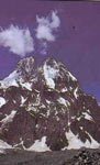
Gilgit, within a160 km radius of
Gilgit there are hundred peaks of over 18,000 feet (5,486 meters) including
which� is the world's second highest mountain. The town of gilgit
is dominated by the 25.550 foot(7,788) Rakaposhi� while Nanga par
bat, 26,660 feet (8,125 meters) high, towers over nearby juglot.Gilgit
itself stands on narrow ,fertile plain entirely ringed around by mountains,
and enjoys a generally pleasant climate except of about two months in
the summer when it becomes oppressively hot.
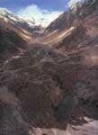
Baltistan is the north east of Pakistan.Skardu,
its capital, is the starting point for some of the best trekking and
mountaineering in the world. Like the rest of Pakistan's Northern areas,
Baltistan is the high altitude desert. It rises from 1500 meters (4920
feet) above sea level to 8616 meters (28268 feet) at the summit of K-2,
the second highest mountain in the world.The average rainfall here is
about 200 millimeters a years.�� ��
�� � �
 ���
���
�
|