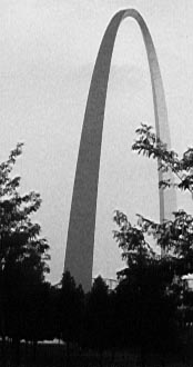
The Jefferson National Expansion Memorial, commonly known as The Arch in St. Louis.
History
St. Louis: History Of A River Town
Pierre Laclede Liguest chose this site to establish a fur trading post at a central location that would not be subject to flooding.
In November, 1763, Laclede and his band of traders from New Orleans landed at what is now the foot of Walnut Street.
Here was a high limestone bluff rising about forty feet above the Mississippi River which sloped back in two or three terraces to the west and extended approximately two miles along the riverfront. This bluff and a growth of timber extended west as far as present day Fourth Street. Beyond was a broad, rolling prairie containing stands of old growth timber, as far west to the horizon.
A small creek flowed into the river below the site, providing a good location for a mill and dam, which later formed the creation of Chouteau's Pond. Its valley marked the south end of the bluff along the riverfront.
After wintering at Fort Chartres, Laclede sent Lieutenant Auguste Chouteau and thirty men to clear the site in February, 1764. Laclede declared, "This settlement will become one of the finest cities in America."
As laid out by the French, the village contained three north-south streets, La Grande Rue (Main Street), Rue d'Eglise (Church Street) and Rue des Granges (Barn Street); now First, Second, and Third Streets. There were several narrower east-west streets including La Rue de la Tour, Rue de la Place and Rue Missouri; now Walnut, Market, and Chestnut Streets. In addition to the block for the post house, squares were set aside for a church and a public place. A fort was built on the hill overlooking the village, at what is now Fourth and Walnut Streets.
Laclede's decision to expand the post into a village was made following receipt of news that France had transferred the land east of the Mississippi to Great Britain. French settlers in the east bank villages of Cahokia and St. Philippe speedily moved to the new settlement on the west bank, causing it to expand immediately into what came to be known as Laclede's village. However, the official name of St. Louis was given to the village by its founder in honor of the Crusader King, Louis IX of France.
The decade from 1830 to 1840 was one of prosperity and growth in the booming river City. The population increased from 6,694 to 16,649. Many new Protestant churches were established, a new Catholic cathedral was erected, the City water works was begun and the public school system was started. In 1840, the cornerstone for St. Francis Xavier Church and St. Louis University was laid at Ninth and Green (Lucas) Streets. The college, opened in 1829, was the first institution of higher learning west of the Mississippi.
Between 1840 and 1850, St. Louis continued rapid growth, both in area and population. An important factor in the population increase was the influx of large numbers of immigrants, particularly from Germany and Ireland. The Germans, who fled the revolution in their homeland, settled here in such numbers that by the early fifties, the City ordinances had to be translated into German for their benefit.
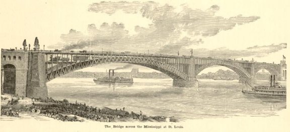
Steamboat traffic was growing rapidly with westward expansion, and this influence was manifested in St. Louis by the animated appearance of its levee and the start of local steamboat construction. The wharf was partially improved and paved after 1831 when the last vestiges of the stone bluff had disappeared. In 1840, the Mississippi River passed St. Louis in two streams of equal size divided by Bloody Island, now part of East St. Louis. This island was so named because it was the scene of numerous duels.
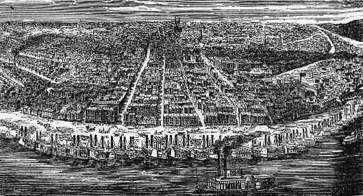
River traffic increased so rapidly that by 1850, St. Louis was the second largest port in point of tonnage in the country, being exceeded only by New York. An English visitor in 1858 was impressed by the levee which "extends along the right bank of the Mississippi for nearly six miles, about half of which length is built upon. " He reported that as many as 170 steamboats had been counted at the St. Louis levee at one time. This was the "Golden Age" of river traffic when some of the finer boats were literally "floating palaces, luxuriously appointed and decorated inside and out with Victorian carpentry.
As river traffic increased, so did St. Louis; during this period, it was the largest City in the nation west of Pittsburgh. St. Louis was a flourishing community when Chicago was only a small town of a few hundred inhabitants on the shores of Lake Michigan. During the development of river traffic, travel by land also began to develop from St. Louis. The City became a terminus for stage coach lines from the east and later was a starting point for similar routes to the west over the Santa Fe and National Trails. The discovery of gold in California in 1849 made St. Louis the outfitting point for many wagon trains heading west.
Edited text of original document by Norbury Wayman, ST. LOUIS CITY PLAN COMMISSION - 1969

![]()
This page is maintained by scubadog.geo. Please email me if you have additonal info or would like more details concerning Kunstel/ Vieth family history in the United States and Europe.