Geographic Location and Political Subdivision
 Click here to enlarge the Island of Panay
Click here to enlarge the Island of Panay
Click here to enlarge the Island of Panay
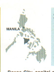
Roxas City is situated at the northeastern tip of the island of Panay within the geographical coordinates of 122 45' longitude and 11 35' latitude. Its boundaries are: Visayan Sea on the north, Municipality of Ivisan on the west, and Municipality of Panit-an on the east. It is located 250 nautical miles southeast of Manila, 136 kilometers northeast of Iloilo City, and 86 kilometers east of Kalibo, Aklan. Travel time to Manila is 50 minutes by air and 18 hours by boat.
The City, classified as the Second Class Component City belongs to the first political district of the province of Capiz along with the municipalities of Maayon, Panay, Panit-an, Pilar, Pontevedra and Pres. Roxas. It comprises forty-seven (47) barangays of which eighteen (18) are urban and twenty-nine (29) are rural.
| Total Land Area | 10,196 hectares or 101.96 sq. km. | ||||||||
| Urban Area | 1,783.1537 hectares (17.49% of the total area)
| Rural Areas
| 8,412.8444463 (82.51% of the total area)
| Major Land Use
| Agriculture - 3,602.0542 hectares | Fishpond - 2,500.9316 hectares Built- Up - 1,744.5199 hectares a. Residential - 11,213.5607 hectares b. Commercial - 221.5775 hectares c. Institutional - 136.2951 hectares d. Industrial - 101.7708 hectares e. Agro- industrial - 71.3158 hectares Soil Type
| Most alluvial in nature such as | beach sand and hydro- soil, bantog clay, San Manuel sandy loam and Luisiana clay loam Climate
| No pronounced season; | relatively wet from May to October and dry for the rset of the year |
 GovernmentHistoryPeopleSocio- Economic ProfileGeography