 |
|
|
|
|
|
|
|
|
|
|
|
|
|
|
|
|
|
|
|
|
|
|
|
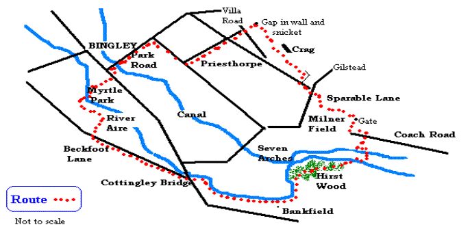
| Run/Walk5 Beckfoot/Hirst Wood/Sparable Lane |
|
|
|
six miles |
|
|
 |
|
|
|
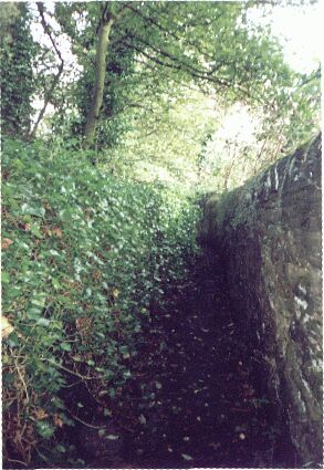
Go down Queen Street, past the Ferrands Arms named after the Ferrand family, based at St Ives, once owners of extensive estates to the west of the River Aire. Much of the estate was sold off after the First World War. Go under the curved arch whose shape echoes that of the hill beyond and down the steps to the river. Watch out for the stone carving, The Throstle Nest of old England,inlaid in the path (the quotation is often ascribed to John Wesley who visited in the 1770's, staying at Myrtle Grove with Mr Johnson Atkinson Busfeild) and head left on the riverside walk. Reaching Myrtle Park, keep right and cross the river on the tubular steel Festival of Britain bridge. Head straight on to the wooden steps leading into the wood. Keep left when the path splits and ascend diagonally to lead to a stile. Go straight ahead behind the house, Hesp Hills, and drop down into the field. Curve round to another stile that takes you into Beckfoot Lane by way of the packhorse bridge built in 1723. Look out for the lanterns on the gable ends of the former farm. The farm dates from the seventeenth century and the lanterns are said to indicate a connection to the Knights of St John. Follow Beck foot Lane with Shipley golf course on your right till you reach the main Bradford road. The Shipley Golf Club bought part of the Ferrand Estate when it was broken up. Cross over the busy main road, and find the gap in the wall on the Bradford side of Cottingley Bridge. Go down the steps and follow the path along the riverbank at the back of the gardens. The large exotic looking pinkish flowers you see all summer and autumn long on the bank are the invasive Himalayan Balsalm.The path leads to the Rugby ground of the Bradford and Bingley club. Carry on along the riverbank under the new bridge until you reach a metal gate and the ivy-blanketed walled snicket that skirts the grounds of the Bankfield Hotel. The high walls here (see left) make for an eerie enclosed atmosphere. |
|
 |
|
|
|
|
|
|
The original Bankfield built in 1848 was a private house, at one time housing a former Bradford Lord Mayor William Murgatroyd, and also, according to historian Harry Speight, when owned by Henry Mason, containing a collection of paintings including works by Turner, Constable and Burne Jones.�� |
|
|
|
�Stick to the riverbank, avoiding the turn right up to Branksome Drive, pass under the railway bridge and enter Hirst Wood. |
|
|
|
The Old English word hyrst can meanbrushwood, scrub or copse so Hirst Wood looks tautological, saying the same thing twice, but the Old English hyrst is a "wooded hill"; Cophurst on the lower Bingley-Marley footpath is next to a striking wooded hill: Cop Hirst Wood. So the variety of old names for hills,� woods� and fields indicates a subtlety of nomenclature which most of us have lost |
|
|
| We take the wide right hand path that leads uphill and goes through the wood coming out at a car park. The wood was of course once more extensive going up to the Bradford Road and becoming Nab Wood that survives only in name. Where the car park now stands there used to be a farm that sold tea, ice cream and other refreshments. Cross over the canal by the swing bridge and turn right. Go through the gap in the wall opposite the Hirst Lock sign and cross over the river by the tubular steel bridge. Bear left immediately and go under the aqueduct towards Hirst Mill weir which is impressive on a wet day. Cross Loadpit Beck on a small footbridge and turn right on the track. To the left is the rowing club. Next turn left on the track leading towards Milner Field Estate. The drive is lined with horse chestnuts, a good place to collect conkers in early October. Just before the south lodge, now a boarding kennels, turn right and soon arrive at the exotic golden-balled metal gate, recently restored to its former glory. Turn left up the partly cobbled track until you come to the sign for Sparable Lane. According to the OED, a sparable or sparrow bill is a type of nail used in boots or clogs. Follow this path down across Littlebeck and round the old Milner Fields estate until you pop out suddenly onto Primrose Lane. Go up the road for a few metres and turn left. Cross over and then turn first right into Pendle Road, then left into Rombalds Drive. Follow this to the end and take the path� which runs under the craggy rock formed by old quarrying. |
|
|
|
 |
|
|
|
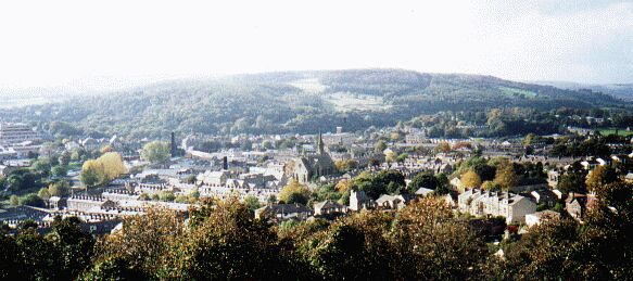
The quarries here were extensive in the nineteenth century and above them was an open area of moorland. The residential area immediately beneath is called Crow Nest, taking its name from an earlier much smaller settlement. Looking down over Bingley you can see why the name persisted. Harry Speight, the Bingley historian, lived here at the turn of the previous century.The Mornington Road church with its spire is now demolished. |
|
|
| �The small crags are excellent for novice or geriatric bouldering. Watch out for the gap in the wall on your left. This leads to a snicket that takes you down between the houses to cross Villa Road. Head down Priesthorpe Road, crossing Priesthorpe Lane and ending up at Mornington Road. Turn right and then left into Park Road (once called Toad Lane) past the fish and chip shop and the old National school, into Bingley |
|
|
 |
|
|
|
Click to return |
|
|
|
|