|
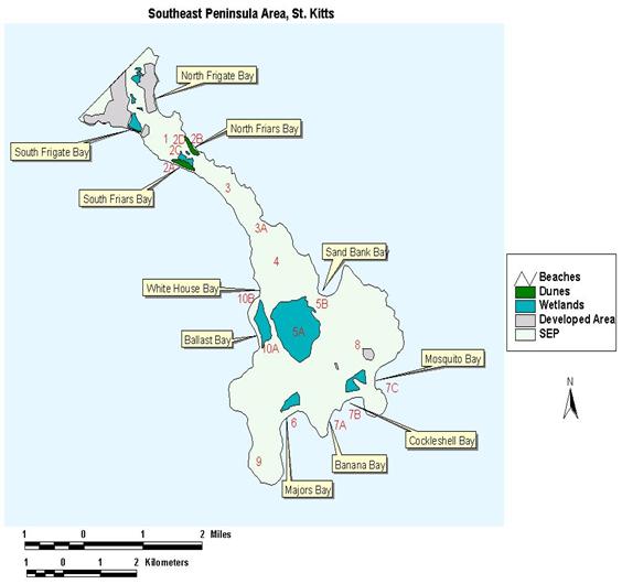
1. Sir
Timothy’s Hill - This 500 feet (183-meter)
high hill separates the SEP from the Frigate Bay
area. Steep slopes and thin soil
cover present a constraint to any major development.
2. Friar’s
Bay Area - The main features of this area
include South Friars Bay beach on the Caribbean (2A) side, North Friars Bay
on the Atlantic (2B) side, a mangrove fringed Friar’s Bay Salt pond (2C) and
a sand dune (2D) located along the North Friar’s Bay beach.
3. The
Isthmus Area - This area is a narrow strip of
land with steep slopes, which present constraints to major development. The only area along here that has any real
potential for major development would be the Canoe Bay
area (3A) with its moderate slopes.
4. Salt
Pond Hill - This hill stands 850 feet (268
meters) high with steep slopes. This
area, which is covered with thorn shrub and mature stands of forest, will
probably remain in its present form.
5. Great
Salt Pond (5A), Little Salt Pond and Sand Bank Bay (5B) - This area consists of ecological communities
including mangrove forest, Caribbean and a dry forest, major sand
dune. The area is considered to
possess the greatest potential for development on the SEP.
6.
Major’s Bay Area - This area includes the
Major’s Bay Bluff, the Majors Bay beach, the Major’s Bay Salt pond, and the
lowlands stretching to Great Salt pond between Major’s Bay Bluff and the
Nag’s Head area.
7. Banana
Bay (7A), Cockleshell Bay
(7B) and Mosquito Bay (7C) - This area consists of a complex of three bays, two
dunes and one salt pond. Both dunes
run along Cockleshell Bay and Mosquito
Bay beaches.
8. St.
Anthony’s Peak - This hill stands at 1,000
feet and dominates the southern end of the SEP. The steep slopes of this hill also represent constraints for
major development.
9. Nag’s
Head Area - This area has been identified as
a principal nesting area for many birds (mainly Brown Pelicans and Great
Frigate birds). Nag’s Head, even
though it has steep slopes, still has potential for development on the top
area which forms a plateau.
10. Little Salt Pond (10A) and White House Bay
(10B)- This area consists of two
bays (White House Bay and Ballast Bay) and one salt pond.
|