Development of a
GIS-based Beach Analysis
and Management System
(BAMS)
by
Edsel
B. Daniel, Ph.D.
([email protected]
)
GIS Overview
|
Geographic Information Systems (GIS) are computer based systems for
storing, manipulating, analyzing and displaying digital data related to
positions on the Earth's surface. The
typical GIS is used to handle various forms of digital maps, which may represent
several different layers. Each layer
holds data about a particular kind of feature. Some common features are streets, rivers, buildings,
vegetation, railway, and coastline.
See Figure 1.
|
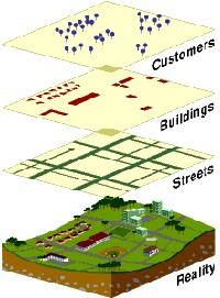
Figure 1. GIS
Layers (www.esri.com)
Under the Post-Georges Disaster Mitigation Project PGDM,
GIS layers (1:25,000 scale) were created for both St. Kitts and
Nevis. Currently, additional GIS layers are generated from aerial
photos (1:2,500 scale) for St. Kitts and satellite
images (provided by the Caribbean Planning for Climate Change (CPACC)
Project) for Nevis. These GIS
layers are becoming an integral part of the day-to-day planning and
mapping operations at the Planning Units in St.
Kitts and Nevis.
GIS… More than a mapping tool
A common misconception about GIS is that its main functions are data
and map creation. Even though GIS does
offer this essential functionality, there are other features such as system
integration and application development, which are
often under utilized. These features
are expected to become more important as end users are demanding user friendly
and customized applications that address specific problem areas.
These applications often require the integration of common desktop
applications (e.g., MS Word, MS Excel, Adobe Acrobat) and databases stored in
various formats. Most GIS packages will
not meet every user’s need but they do offer a customizable environment for
developing such applications. The
development of a prototype GIS-based Beach Analysis and Management System (BAMS)
is part of an effort to tap into and utilize these GIS customization
resources to build better decision support systems. Click here to see
BAMS user interface.
BAMS…What does it offer?
BAMS is a GIS based decision support system developed as part of a research
effort to:
a. Improve the tool available
for analyzing beach profile data collected under the UNESCO-COSALC Beach Monitoring Program and
b. Expand the results of a coastal
erosion hazard assessment that was completed as part of the Post Georges
Disaster Mitigation Project for St. Kitts and Nevis.
It was designed for planners and coastal managers to manage coastal
resources and beach erosion hazards.
The customized tools described in the following sections were based on
user requirements identified during interviews held with staff from the PPD,
Fisheries Unit and Department of Environment.
The Southeast Peninsula was chosen as a case study
area for developing and demonstrating system tools and functionality.
BAMS was developed with ESRI’s ArcView 3.2 and ArcIMS 4.0 (Internet) GIS software, and consists of three
main application components: Beach Analysis; Predict Episodic
Beach Changes; and Setback Analysis.
Beach analysis tools focus on displaying coastal
data layers (e.g., coastline, reefs, contours, bathymetry, dunes, COSALC
monitoring reference site), analyzing beach erosion data and disseminating this
information on a stand-alone system and via the Internet. Options are available to integrate beach
profile data and linking it with the corresponding COSALC reference sites. Routines are available to calculate
long-term beach change rates and sand volume changes for individual
beaches. This allows the user to
investigate various trends between different time periods, as well as identify
erosion-sensitive beaches.
System flexibility is demonstrated through the ability to integrate and
analyze data from various sources and formats, including COSALC beach profiles,
sediment rates, and marine debris. Internet GIS tools are also used to expand
system functionality so that other stakeholders (e.g. public, NGOs) can access
basic beach erosion hazard information via the Internet.
Predicting
episodic beach changes tools focus on predicting beach erosion during extreme
storm events and calculating erosion damage probabilities. Limited data prevented the use of more
advanced modelling techniques such as numerical models. However, available data supported two
models: geometric model (GM) and extreme value distribution (EVD). The GM model uses the beach profile
characteristics, extreme probability values for storm surge and significant
wave height to predict beach changes. The EVD model predicts beach erosion based on
statistical/probabilistic
analysis of the annual maximum beach
width changes (extracted from COSALC beach profile data).
These erosion prediction tools can be used by coastal managers to
better analyze and understand coastal erosion hazards. For example, the EVD model can assist with
assessing erosion damage exposure and probabilities for existing and proposed
facilities on individual beaches.
Setback
analysis tools
focus on routines and tools for calculating and evaluating individual beach setback
distances. Within BAMS, variations in
storm-induced beach erosion and long-term erosion due to sea level rise are
explicitly considered when calculating setbacks. EVD or GM model is used to estimate the storm-induced beach
erosion. Planners would be able to
design individual beach setbacks in accordance with the Planning and
Infrastructure Guidelines and Standards.
This method is an improvement of the existing method of a minimum
setback for all beaches. Additional
tools are available to evaluate cost components for different setback scenarios.
What next?
The ultimate goal is to implement BAMS in islands that collect beach
profile data under the UNESCO-COSALC program.
Coastal managers and planners would be able to use BAMS as a decision
support tool for coastal management strategies. For example, BAMS could be used to guide solutions to typical
coastal management questions such as:
· What have been
the erosion/accretion (meters per year) trends and beach sand volume change
patterns (cubic meters per year) over a specific time period for a
particular beach?
·
Where are the beaches that have displayed an erosion rate pattern above
a threshold level during a specific period? How many tropical systems passed
during that period?
This information would be useful in determining:
· A
rotational beach sand mining program where certain beaches can be mined during
periods when beach volume is expected to increase.
· Sediment
sources and sinks.
· Criteria for prioritizing beach
restoration activities or monitoring.
To increase the use of BAMS, seminars/meetings are organized with
potential users and other interest groups. These activities are designed
to:
· Confirm that user requirements are met.
· Obtain feedback on BAMS.
· Identify priorities for future
research and coordination with other research efforts at the local and regional
level, namely CPACC.
· Use BAMS to sensitize stakeholders on
Integrated Coastal Zone Management (ICZM) and related issues.
To date, seminars and meetings have been held with:
· Staff from Department of Environment
and PPD, St. Kitts.
· Staff from the Planning Unit and other Government
Departments, Nevis.
· Staff at the Fisheries Unit, St.
Kitts.
·
Dr.
Gillian Cambers, UNESCO-COSALC Coordinator, University
of Puerto Rico.
· Dr. Robin Davidson-Arnott, Professor, Geography Department, Guelph University.
· Mr. Alan Mills, GIS Officer, Planning Authority, British
Virgin Islands.
The feedback received was positive with an overall indication that user
requirements are being met. Dr. Cambers
and Mr. Mills also provided useful suggestions on how to modify BAMS for other Islands. Future collaborative work on improving beach
monitoring methods will be explored with Dr. Davidson-Arnott.
Additional technology transfer activities planned include:
a) Creation and dissemination of BAMS user manual.
b) Publish BAMS results in coastal management journals.
c) Test/evaluate BAMS prototype with potential users in the
Department of Environment, Fisheries Unit and PPD.
d) Assist the UNESCO-COSALC program with investigating the
implementation of BAMS in other islands, and improving data collection
methods.
e) Investigate the possibility of integrating BAMS with other
systems such as CPACC’s Coastal Resource Information System.
f) Investigate more advanced and robust erosion modelling
techniques.
g) Migrate BAMS from ArcView 3.2 to the new ArcView 8.2
version.
Closing Remarks
BAMS provides an excellent
start for utilizing existing coastal data and GIS
technology to develop and implement decision support systems
within an ICZM framework.
With continued effort at BAMS dissemination, coastal managers and
planners can become aware of these capabilities and apply them in their
day-to-day activities.