VIET NAM 4 DAYS 3 NIGHTS /ANGKOR 3 DAYS 2 NIGHTS
VIET NAM 4 DAYS 3 NIGHTS
SI SA KET – MUK DA HAN – SAVANA KHET - VAY – HOI AN – DA NANG
There is always a warm welcome with the memorable journey to sense the sweet touch of Laos and Viet Nam. Taking you crossing the Thai-Laos border through Mukdahan onto Savana Khet, observing and appreciating the enchanted Indochina from natural resources through rural lifestyles. Vietnamese musicians play hometown instruments on the night cruise in Vay Town, visiting Tiem Mu temple, the Palace and the Royal Tomb. The breathtaking mountain in Danang, Jarm’s Museum and Sculptors, calling upon the world heritage town ‘Hoi An’ where you will see Chinese-Japanese sculptors, touching Hoi An beach atmosphere and the memorable bridge of love (from the movie). Afterward in Mukdahan, the Indochina Market beside the Khong river, plenty of incredibly cheap gadgets and souvenirs there awaiting your call.
For more information concerning the detail itinerary please contact us.
(66)045-612-929 ,(66) 081-876-1814 [email protected]
ANGKOR 3 DAYS 2 NIGHTS
SISAKET – CHONG SA NGAM – SIEM REAP – ANGKOR WAT_ANGKOR THOM
Discover the charm of rural livelihood along the journey, an hour ride to the border and about 141 kilometers from the border pass, to one of the most brilliant wonders of the world the glorious “ Angkor”. With the highlights of the ancient site during the day, you will also, enjoy the enchanting cultural dancing at night. The colorful old market with its souvenirs and gems as well as local products is quite a fascinating site.
For more information concerning the detail itinerary please contact us.
(66)045-612-929, (66)045-620766,(66)081-876-1814 [email protected]
Top
ABOUT VIETNAM Top
It is quite strange that more than a decade after Vietnam opened the doors to the travel and tourists and investors, who want to travel to Viet Nam, the information of this country is still so poor and unsystematic.People wonder what is behind an Asian nation that had been under a thousand years of feudalism, and a century of two bigger Indochinese Wars. And above all, it's still a communist state.
What Vietnam is really like?The wars have been relegated to museums, memorials and historical vestiges. Four natural and cultural draws have been designated as World Heritages by UNESCO within 7 years. And the visitors, of which the French led the way since 1990s, have pleasantly noted warm smiles and friendly faces every corner. The time-limited tourists are happy that they can visit various kinds of landscape, vestiges and lifestyles within a reasonable time. Those who love ecotours are amazed discovering that they can get apart from the urban excitement for as long as they can and mix them up with hill tribes in remote regions. And who just returned after a few years offer excellent comments on the remarkable development of infrastructure. You assuredly need a good local friend to get you delve into these wonders.
A SHORT PROFILE Cities: Hanoi is the Capital. Ho Chi Minh City (normally called Saigon) is the largest city and more exciting industrial centre. Hue, the Capital of the last Kingdom up to 1945 is still maintaining traces of the old reigns. Main seaports are Haiphong, Danang, Saigon.
Population: 78 millions. 54 ethnics. The Kinh (or Viet) ethnic forms around 85% of population and mostly inhabit in larger towns. A larger Chinese community of less than 2 millions inhabit mainly in Hochiminh City.
Area: 332,000 km square, roughly the area of Italy or Japan
Shape: Neither boot-shaped nor gathering hundreds of islands.
A huge "S" lying half-facing the Pacific Ocean as per a proud local expression
Land Borders: North to China, upper West to Laos, lower West to Cambodia, East and South to Pacific Ocean.
Sea Borders: Northeast to East Sea or so-called South China Sea, Southwest to the Gulf of Thailand.
Climate: Tropical monsoon. 4 seasons in the North, dry and rainy seasons in the South. Conditions vary North to South with elevation changes.
Geography: 75% of the territory is Limestone Mountains, the rest are river deltas, fertile highlands, and small deserts
Language: Vietnamese. Don't ask the local people do they understand Chinese naturally. Vietnamese is a tonal language using Roman letters together with tone markers - main problems of foreign students. English is the most popular foreign language and French, Chinese, Japanese are expected to speak at service points. Literacy rate is 88%
Religion: Figures are different. Estimated 60% – 70% of population believe in Buddhist tenets with strong Confucian and Taoist influences. Catholic account for perhaps 8% – 10% of the population. Cao Dai and Hoa Hao, local sects of Buddhism, are strong in the Mekong delta.
Government: Sole-party Socialist Republic under the leadership of the Communist Party. Important persons to name are the Party's General Secretary (Mr. Nong Duc Manh), the country's president (Mr. Tran Duc Luong), the Prime Minister (Mr. Phan Van Khai). The leading offices are Politburo and National Assembly.
Economy: Market-based economy. Third world leading rice exporter and coffee exporter (wow!!). Other exported goods are rubber, tea, crude oil, coal, and electricity.
Festival: New moon and full moon days are main anniversaries at temples. Main Festival of the year is the Lunar Calendar New Year ("Tet") which often falls in mid-Feb. For 5 days to a week most of businesses closed except tourist points. Flower markets every where before the Eve. Temples and shrines are exciting with traditional anniversaries and pilgrims before and after Tet. Transportation is booked solid during this time.
Top
HOI AN Top
Hoi An town is small and peaceful, the kind of place where you may get stuck for a few days, whether it is intentional or not. Originally known as Faifo, this antique town is bordered on its southern side by the Thu Bon River, along which there's a number of small cafes. Despite the fact that it is now a tourist haven, the artistic atmosphere and local friendly people create an inviting environment. Hoi An was an important port developed in 17th century and remained so for a long time. There used to be canals parallel to the streets, so merchandise could be loaded straight from the back of houses onto the boats. Hoi An’s continuance as a port lasted right up until the early years of the 20 century, when the river became silted up forcing the cargo ships to call at Da Nang instead.
In the past Hoi An has been used by the Japanese, Portuguese, Dutch, French and the large remaining Chinese community where all sorts of produce and wares were traded. Remnants of these past traders’ influences can still be seen lining the streets of Hoi An. There are nine different types of historical sites in Hoi An with an average age of 200 years. They include private houses, family chapels, community halls, communal houses, temples, pagodas, bridges, wells and tombs. Many of these buildings have been maintained close to their original form, allowing you imagination to recreate a prosperous trading town. The houses are small and colorful with wooden doors and two round "wooden house's eyes" above, window shutters and ornamental furniture. A pleasant change from the iron bars and metal grates of other towns. Hoi An is full of shops selling artwork, from lifelike memorial family portraits, to stylized images of Hoi An houses and streets. Next door to the art shops are places selling souvenir statues, ceramic plates, and ‘antique’ bowls. At the market place beside the river, you can pick up almost anything you want. Tourists are often being lured into the markets to buy silk and to have quality garments tailor made. You can have anything from dresses and trousers to shirts and hats made for a cheap price.
Another noticeable quality of Hoi An is its relative silence. There are few cars and people do not feel the urge to use their horns every two seconds. The streets are filled with the hum of voices, motorbikes and the shuffling of thongs along the ground. Hoi An is small enough to get around on foot, and you will need a set of wheels if you are going to Cue Dai(cudai) Beach, or on a day trip to the Marble Mountains or Da Nang. A relaxing activity around sunset is to hire a boat from the waterside by the market place. Many of the locals will wait on the river and offer you this service throughout the day and night
Top
DA NANG
Da nang was the landing point of both the French and the Americans during their stints in Vietnam. When the French established a garrison in Da Nang (then called Tourane), more soldiers died from disease than the associated fighting in establishing the garrison. There is now a small cemetery dedicated to them.During the Vietnam War, Da Nang was the home to one fifth of all US servicemen based in Vietnam. This made Da Nang on of the heaviest defended cities in South Vietnam, yet it eventually fell to the North Vietnamese in 1975 with hardly a bullet fired. Da Nang marks the halfway point between Hanoi and Ho Chi Minh City and was the first place to organize its own local communist party committee. The city is fairly featureless, and if you are coming from the tranquil setting of Lang Co, Hoi An, or anywhere for that matter, Da Nang is an extreme disappointment. It is a busy, dusty, colorless city, the fourth largest in Vietnam, and one of the largest business centers. Unless you are in Da Nang for business, chances are you will pass straight through. Da Nang does have a fascinating Cham Museum that contains an excellent collection of Cham art. However, the main reason for staying in Da Nang is in the surrounding region. China Beach, the Marble Mountains, Hoi An and My Son are all within striking distance of Da mange, though it is more pleasant to stay in Hoi An and visit these sights.
Top
ABOUT LAOS
Laos is the least developed and most enigmatic of the three former French Indochinese states. A ruinous sequence of colonial domination, internecine conflict and dogmatic socialism finally brought the country to its knees in the 1970s, and almost ten per cent of the population left. Now, after decades of isolation from the outside world, this landlocked, sparsely populated country is enjoying peace, stabilizing its political and economic structures and admitting foreign visitors - albeit in limited numbers due to a general lack of infrastructure.The lack of foreign influence offers travelers an unparalleled glimpse of traditional South-East Asian life. From the fertile lowlands of the Mekong River valley to the rugged Annamite highlands, travelers who have made it to Laos tend to agree that this country is the highlight of South-East Asia.
A BRIEF PROFILE Country: LANGXIANG ( millions of elephants )
Cities: The Capital is Vientiane municipality ( Vientiane province is another provincial administration). Luang Prabang, the Ancient Capital of last Kingdom is still maintaining traces of the old reigns. Other major cities are Savannakhet ( with 766,000 people ) and Champassaks ( with 572,000 people )
Population: It was estimated that, the population of Laos was 5.2 million and is growing at an annual 2.4%. The average population density is 21 per square kilometers, giving Lao the lowest population density in Asia. Around 85% of the population are farmers and live in rural areas. Over 70% (2,220,547) are engaged in productive work, and 936,870 are unemployed, a classification which includes students (69.4%), domestic workers (12.6%), the aged (14.6%). There are 576,758 people at work in towns, and 2,580,659 work in the countryside. There are 3 main ethnic categories: Lao Loum (low landers), Lao Thueng (lower mountain dwellers), and Lao Soong (high landers). The great majority of Lao are Buddhist.
Area: Approximately 70% of its total area (236,800 square kilometers) comprises of mountain and plateaux areas. Roughly the area of Italy or Japan
Land Borders: North to China, North West to Myanmar ( Burma ), West to Thailand, South to Cambodia, East to Vietnam.
Sea Borders: Laos, one of the few countries in the world doesn't have sea border.
Climate: Laos has a warm and tropical climate with two seasons: the rainy season from the beginning of May to the end of September and the dry season from October to April. The average temperature is 29 degree centigrade. Maximum temperature can reach up to 40 degree centigrade. Temperatures can drop to as low as 15 degrees or even lower in mountains. In Vientiane minimum temperatures of 19 C are to be expected in January. In mountainous areas, however, temperatures drop to 14-15 C during the winter months, and in cold nights easily reach the freezing point.The average precipitation is highest in southern Laos, where the Annamite Mountains receive over 3000 mm annually. In Vientiane rainfall is about 1500-2000 mm, and in the Northern provinces only 1000-1500 mm.Generally, tourists are recommended to visit Laos during the months of November to March because these are cool months and rainfall is lower than other periods.
Geography: With over half of this landlocked country's 236,800sq. Km densely forested, and 70% of it mountainous, it is hardly surprising that a profusion of rare flora and over 1,200 species of wildlife finds a home beneath its tropical canopy. Approximately 70% of its total area (236,800 square kilometers) comprises of mountain and plateaux areas.The mighty Mekong in the west and the Annamite Mountains in the east offer natural borders to Thailand and Vietnam respectively. Almost all of the rivers and streams in Laos eventually end up feeding into the Mekong through one of its 15 tributaries, making a total of 2,400km of waterways and feeding the Mekong with more than half of its overall water flow.Though averaging rainfalls of between 1360mm, in Luang Prabang, to 3700mm on the Boloven Plateaux during the June to October monsoon season, Laos regularly suffers from water shortages in the low-lying Mekong Delta plains. This can adversely affect the rice crops that account for almost 80% of the country's agricultural land. The country's highest peak, at 2,820m, can be found in the mountainous ranges of northeastern Laos, in the province Xiang Khouang, However, nearly equally as impressive are the mountains at the southern end of the Annamite range which reach heights of 2,600m. The Khammouanne and Bolaven plateaux dominate the central region of the Annamites.
Language: The official language used in Laos is Lao language. However, the usage of the language can differ from north and south. English, French and Russian are spoken in business or by some senior government officials. Many shopkeepers can understand basic English and French.
Religion: Buddhism first appeared in Laos during the eighth century A.D. as shown by both the Buddha image and the stone inscription found at Ban Talat near Vientiane, now exhibited at the Museum of Ho Prakeo. After the foundation of the unified Kingdom of Lane Xang, King FaNgum (14th century) declared Buddhism as the state religion and urged the people to abandon animism or other beliefs such as the cult of spirits. His policy meant to develop the Lao culture based on a common faith: the Theravada Buddhism. Today Theravada Buddhism is the professed religion of about 90% of Lao people. Buddhism is an inherent feature of daily life and casts a strong influence on Lao society. Lao woman can be seen each morning giving alms to monks, earning merit to lessen the number of their rebirth. Lao men are expected to become a monk for at least a short time in their lives. Traditionally they spent three months during the rainy season in a Wat, a Buddhist temple. But nowadays most men curtail their stay to one or two weeks.
Government: The highest position in the Lao government is the President (Mr. H.E. Khamtay Siphandone), who is elected every five years by the National Assembly. This head of state also acts as the Commander in Chief of the country's armed forces. The highest executive organ in the Lao government is the Council of Ministers, this is headed by a Chairman, who also acts as Prime Minister (Mr. H.E. Bounnyang Vorachit), , with Vice Chairman ( Mr. H.E. Somsavath Lengsava ) overseeing the work of government ministers.The country's 16 provinces (khoueng) are further divided into districts (muang) and villages (baan). Vientiane contains its own municipality - or kampheng nakhon - and the special zone of Xaisomboun, in the northeast of the province, was established in June 1994. A further special zone was set up in mid-1992 with the integration of two districts of Xaignabouri.
Economy: The economic structure of the Lao PDR consists of many sectors under different forms of ownership and economic organizational system, but these sectors are equal before law and operate under the management of the state with the view to freely cooperate and compete in their business activities. Were it not for the persistent problems of regional flooding, drought and insect infestation, Laos would be permanently self-sufficient in food. 80% of the country's workforce is involved in subsistence agriculture, which makes up about half of the GDP, with glutinous rice the country's main agricultural produce. Also grown for local use are maize, cassava, pulses, groundnuts, fruits, sugar cane, and tobacco, while main exports include timber and wood products, garments, coffee, and tin, mainly to France, Germany, Thailand and Vietnam. Laos also has, largely untapped, reserves of tin, lead and zinc, as well as iron ore, coal and timber. A member of both the Asian Development Bank and the Colombo Plan, which promotes economic and social development in Asia and the Pacific, Laos, still struggles with a very basic infrastructure. Many roads are impassable during the monsoon and there are no railways. Only large urban areas have access to regular power supplies, while telecommunications are still very basic.In Laos, working days are from Monday to Saturday, from 8 a.m. to 12 a.m. and form 2 p.m. till 5 p.m. A variety of festivals and religious ceremonies are observed throughout the whole year.
Top
ABOUT SAVANNA KHET
Savannakhet town is situated on the banks of the Mekong River opposite Mukdahan in Thailand. The province bridges the country between Thailand and Vietnam and the town is a very active junction for trade between the two countries. The town itself can be easily explored by foot and has a number of interesting temples, including Vietnamese temple and school and a large Catholic church. Much of the town's architecture is French Colonial. Numerous examples of French architecture tell of the town's importance during the colonial era.
Getting there
You can reach Savannakhet by boat from the north ( Vientiane, Tha Khek) or the south (Pakse), although these services change regularly. Buses run several times a day from Vientiane, Tha Kek and Pakse. The journey takes up to nine hours from Vientiane.From Thailand: Savannakhet is a designated international border checkpoint, although visas are not available on entry. You will need a visa in advance or you will have to make arrangements with a tour company. The ferry from Mukdahan, in Thailand runs all day between 0830 and 1700 on weekdays, with some restrictions at weekends.From Vietnam: The Vietnamese border town of Lao Bao can be reached 180km west of Savannakhet on Route 9. Tourists can freely pass between Laos and Vietnam, but note that visas are required in advance by both countries.
Top
The Ho Chi Minh Trail
During the Vietnam war, the North Vietnamese Army (NVA) used a network of trails, caves and gravel roads to move ordnance, tanks, trucks, men and provisions to South Vietnam. The trail became known as the Ho Chi Minh Trail and its existence at the time was denied by the NVA. The USA, on the other hand, denied saturation bombing the Trail, within Laos - with 900 sorties per day and over one million tones of explosive.All of the jungle area of the Trail, previously destroyed with defoliants and herbicides has grown back. It is possible to visit parts of the trail - but this must be done with a guide, since there remain tones of unexploded ordnance (UXO) in the area. Venturing off by yourself is not recommended!
Other places Khanthebouly's main attractions are its noteworthy temples such as the beautiful Wat Saya Phoum and That Inghang.That Inghang Stupa is one of the national stupa, which is the holiest edifice in southern Laos, housing a hollow chamber with a distinguished collection of Buddha images. It was built by King Sikhotabong and located about 15 km east from the provincial capital of Khamthabouly.
That Phon stupa is one of the significant stupa since it was contracted between the year of 557 to 700. The contraction was taken quite a long time. Festival rite is annually organized in the full moon of the first month of lunar calendar to play respect to Phra Shiva and other Lords of Hinduism.
Heuanehine or Stone House, the rocky house designed by Kham people is also one of the most interesting sites in this province. Not as old as these prehistoric relicts, but of no less significance, is the northernmost example of Khmer art at Heuan Hin (stone house). The building was constructed between 553 AD and 700AD. Today little more than unrestored ruins remain.
Near Muang Phin, on the route to Vietnam, dinosaur remains are on display. A French scientist discovered them in the 1930s.Dinosaur Exhibition Hall is situated in Khanthabouly, the capital city of the province. Daily opened from 8.00 to12.00, and afternoon from 13.00 to 16.00, starting from Monday to Friday.
Hortai (Wat Nonglamchan village) is the old wooden building where the Buddha's words have been kept.One of the tourist attractions in Savannakhet is the beautiful waterfall.
Top
ABOUT CAMBODIA
The Four Horsemen of the Apocalypse - Conquest, War, Famine, and Death - have ridden roughshod over Cambodia. During the 1970s this country used to suffer from the twin horrors of war and famine – which made the Vietnamese neighbor call it “a land of blood and tears, hell on earth”.So it’s really a wonder meeting with the friendliest people of Indochina who have the widest smiles here nowadays. Their willingness to start anew speaks volumes for the resilience of the human spirit. Here’s a country starting from scratch, rebuilding its traditions, culture, laws, government and economy. The gruesome past is still around – after Khmer Rouge time, thousands people have still been maimed by landmines.
As a symbol of reconstruction, the country flies the world’s only flag with a building on it – the triple towers visible from the causeway at Angkor Wat. All political factions, including the Khmer Rouge, have depicted Angkor Wat on their Cambodia flag. The Cambodian government officially claims all the foreigners’ use of “ Angkor” as their product brand names as an “illegal and unfriendly act”. The Foreign Affairs ministry argued that Angkor Wat is the symbol of Khmer national identity.
And so it is : Angkor is the cornerstone or Khmer culture, symbol of national pride and past greatness, and inspiration for painting, sculpture, and woodcarving. Angkor is also a symbol for hope, because it is Angkor that draws tourists, and foreign exchange generated from tourism can help rebuild the economy. Angkor casts its spell over all who visit. Despite the risks of travel - or perhaps because of them, Cambodia is an extraordinary adventure.
A BRIEF PROFILE
Country: Nearly untouched by tourists, except for Angkor
Cities: Phnompenh, the capital city, and Siem Reap, 7km from the wonder of Angkor, are the two largest political, cultural and economic centres.
Population: Estimated at 12 million. The Khmer constitute 90% of the population. The remainder is composed of hill tribe groups, Cham, Vietnamese (1%), Chinese (4%), and Thais. The biggest population concentrates in Phnom Penh, with more than one million people.
Area: 181,035 square km, roughly a half of Italy or Vietnam.
Land Borders: North borders Laos, the entire East to Vietnam, and shares a long part of North and Northwest borders with the land of Thailand.
Sea Borders: Southwest, to the Gulf of Thailand.
Climate: The average precipitation is highest in southern Laos, where the Anna mite Mountains receive over 3000 mm annually. In Vientiane rainfall is about 1500-2000 mm, and in the Northern provinces only 1000-1500 mm.Tropical monsoon, with two periods of rainfall. The sequence of the seasons is hot, very hot, light rain, and heavy rain. High humidity is throughout and sometime up to 90%. April, then March and May are the hottest months. Early June to early October has heavy rains and humidity due to the southwest monsoon arises over the Indian Ocean. The wettest months are August and September. November to March is cool and dry, the best time for your visits.
Language: Khmer, the official language, is a non-tonal language of the Mon – Khmer family, enriched by Pa li and Sanskrit. English is the second major language, closely followed by French, Vietnamese, Chinese, and Russian are also spoken in Cambodia. Literacy rate is 60%, a legacy of the Pol Pot years.
Religion: Religious people accounts for 95% of the population. Theravada Buddhism was almost annihilated under the 1975 – 1979 reign of terror of the Khmer Rouge, but it has since been reinstated as the national religion of Cambodia. Minority groups adhere to other religion such as Catholicism (mainly Vietnamese) and Sunni Muslim (Cham). Government: Constitutional Monarchy. UN-supervised elections in 1993 resulted in a coalition government composed of FUNCINPEC (United Front of an Independent, Neutral, Peaceful, and Cooperative Cambodia) and CPP (Cambodian People Party). The Prime Minister is Hun Sen. King Norodom Sihanouk is the Head of the State.
Economy: Agriculture employs about 75% of the workforce. Top exports are timber, rubber, cane furniture and garments.
Festival and official Holidays: The biggest festival is Cambodian New Year in mid-April, similar to Laos and Thai celebrations. In November there are boat races to celebrate the reversing current of the Tonle Sap River.
Top
ABOUT SIEM REAP
Siem Reap is the small gateway town to ruins of Angkor, located 250 northwest of Phnom Penh and 15 km north of Tonle Sap. Running through the centre of town is the polluted Siem Reap river. Traces of French presence have survived in a small quarter of colonial buildings to the southwest side the rest of Siem Reap was badly damaged by bombing and civil war. In the early 1979-0, during the Pol Pot era, people were fed to the crocodiles in Siem Reap. There is a “killing fields” memorial to victims of Khmer Rouge to the northwest of the town. In 1979 the province was the scene of heavy fighting between the Khmer Rouge and the Vietnamese Army. Since 1990 the Khmer Rouge has staged sporadic attacks on the civilian population and Cambodian troops around Seam Reap. In 1993 they massacred Vietnamese fishing families at Lake Tonle Sap, precipitating an exodus of the Vietnamese to the Mekong Delta.
To safeguard Angkor, the government has stationed troops, ringing the entire zone of ruins.Peace has not been easy to come to Siem Reap, but there is normal life around Angkor: farmers transporting goods in oxcarts, village women clad in sarongs cycling to market, Buddhist monks in the flowing orange robe out morning strolls, kids lolling about on the backs of water buffalo in green fields. For tourists this is a chance to see rural life.
For local, tourist itself, however small in scale, is seen as return to normalcy after years of savage war and upheaval. A number of new hotels, guesthouses and restaurants have appeared in Seam Reap in the 1990s, catering first to visiting UNTAC troops and later to the Angkor bound tourists who arrived in the wake.
ABOUT ANGKOR Top
ANGKOR CONSERVANCY
ANGKOR IN DETAILS
ANGKORIAN ARCHITECTURE
WHAT SURVIVED?
ANGKOR HIGHLIGHTS
ANGKOR ROUTE STRATEGIES
The story of finding Angkor is a long sequence. With a retinue of bearers, eccentric French naturalist Henri Mouhot hacked his way through the Cambodian jungle in January 1860, in search of beetles and butterflies. Though his interest lay more in insects than antiquities, he spent three weeks exploring the ruins of Angkor. He arrived by way of Lake Tonle Sap, where, he noted, fish were so abundant that they impeded the progress of his boat. As a collector, Mouhot was entranced by butterflies with the size of soup plates lazing on the stones. He was also intrigued by the stones themselves. In his diaries he claimed Angkor’s ruins were grander than those of ancient Greece or Rome. He raved about a monument equal to the temple of Solomon, erected by some ancient Michelangelo. The sight of the ruins, he wrote in his diary, made the traveler “forget all the fatigues of the journey, filling him with admiration and delight, such as would be experienced in finding a verdant oasis in the sandy desert. Suddenly, and as if by enchantment, he seems to be transported from barbarism to civilization, from profound darkness into light. Mouhot was not the first European to visit Angkor. A long line of traders, missionaries, and travelers had passed this way before him in the 17th, 18th, and 19th centuries. In fact, Mouhot’s visit was inspired by the travels of French missionary Charle - Emile Bouillevaux, who visited in 1854. For some reasons, the reports of others had gone unnoticed by the West. Mouhot, traveling under the auspices of England’s Royal Geographical Society, was the most publicity conscious of the visitors. He died in Laos in 1861 from a malarial fever; his diaries and tale correspondence was published posthumously 1863 in magazine called “Le tour du Mond”, triggering European interest.
More writings, focusing as much on natural wonders as on archaeology, appeared in a book “Voyage in Siam” in 1868. Englishman John Thomson took the first photographs of Angkor in 1886, and the ruins exercised a powerful hold on the 19th century European imagination. The image of ruined temples emerging from thick jungle vegetation became part of colonial romanticism the lost city rediscover.It was not until after World War II, when archaeologist Bernard Groslier made aerial surveys of the area, that the full extent of Angkor was realized.
Angkor comprises 70 monuments scattered over an area of 200 square Km. The complex tombs, temple, palaces, moats reservoirs, and causeway was built over a period of 400 years; only Egypt’s Nile Valley can compare to this array of monuments.There’s nothing like Angkor in Southeast Asia. Only two monument complexes come close: 9th-century Borobodur in Indonesia, and 11th century Pagan in Burma. The French could not imagine that the Khmer kings were responsible for such monumental work.
The theories as to who constructed Angkor’s monument ranged from the ancient Romans to Alexander the Great. Indeed, the structures echo styles from other monumental ruins. Angkor Wat is built in classical Indian style, with elements of the Java ziggurat of Borobodur, and yet the numerous bas-reliefs have a strangely Egyptian character. The columns and arches at Preach Khan Temple, evoke those of the Greeks and Romans, while the Pyramid of Phimeanakas resembles those of the Maya at Tikal, Guatemala.The inspiration for Angkor architecture came from a unique mix of Hinduism and Buddhism. The early rules of Angkor promoted various Hindu sects, mainly dedicated to Shiva and Vishnu. Shiva was initially the most favored deity, but by the 12th century, Vishnu had replaced him. At the same time the king encouraged Buddhist scholarship; Jayavaman VII introduced Mahayana Buddhism as the court religion by the end of the 12th century. Layered onto these concepts was the tradition of deification of kings in sculptural form. This mix resulted in Angkorian structures that have no parallel, such as the fantastic South Gate of Angkor Thom and the bizarre Bayon.
Back to About Angkor / Top
ANGKOR CONSERVANCY
Anything moveable at Angkor has disappeared. Even the heads of the larger stone statues have been hacked off by treasure hunters. To guard against art theft, virtually all smaller Angkor statuary, wood items, and artifacts have been removed to museums, particularly to the National Museum in Phnom Penh. Thousands of pieces rest at the Angkor Conservancy, located several km to the north of Siem Reap, and you will need special permission from the Ministry of Culture in Phnom Penh to visit. The Angkor Wat Conservancy was established by French in 1907 when Siem Reap province was restored to Cambodia by the Thais. From 1953 to 1970 the Angkor Conservancy was jointly operated by the French and Cambodian governments. With the exception of period during WW II, the French at Angkor worked steadily, at times directing more than a thousand employees. In 1972 the civil war forced the French to leave.Angkor Conservancy is a warehouse for some 7,000 sculpture fragments and artifacts from the Angkor region. Fresh concrete heads are stocked here, destined to replace ones removed from the Angkor area by bandits or Khmer Rouge. Museum staffs also removed heads before bandits can get to them. There are two floors of statuary at Angkor Conservancy. On the ground floor are the larger Buddhas, Vishnus, and lintels; the upper floor houses smaller Buddhas, hand fragments, stone animals and large wooden Buddhas. Unfortunately, the pieces are not safe even here the place has been broken into several times.
Back to About Angkor / Top
Angkor in details
TIME OUT IN SIEM REAP If you spend a week or so in Angkor, it’s best to pace yourself: one day at the ruins, one day off. Otherwise you’ll suffer from cultural overload and become “temple out”. Siem Reap presents a great opportunity to get out into the Cambodian countryside. You can witness facets of rural life unchanged from those depicted on the temple walls at the Angkor Wat 800 years ago. Roads are rough in these areas, some time just dirt tracks. Taking a tour guide along is highly recommended; he can show you around the villages and show you how palm sugar and palm wine are brewed.
THE WEST BARAY To reach the West Barray, head northwest from Siem Reap along Route 6. Pass the airport road and take the next turnoff to the right; this leads to a parking area at a dam at the south side of the West Barray. The West Barray reservoir was part of the elaborate Angkorian irrigation system, although researchers are not sure of its exact function. Originally, the West Barray and East Barray were two gargantuan artificial lakes. The West Barray is a two by eight km rectangle enclosed by an earth dike. Though it may have been used for irrigation, recent evidence indicates it was more likely a mooring place for royal barges, a fish-breeding site, or simply a place for bathing.The East Barray is now dry. The West Barray, first constructed in the 11th century, was partially restored in the 1950s with foreign-aid funds. Today is about two-thirds full. The West Barray is fed by the Tonle Sap River; a small dam has enlarged the rice-growing potential of the area with water carried through a network of irrigation canal. The West Barray is also used for fish breeding. You can go for a swim along southern section. Situated in the West Barray is a small island you can hire a boat and row out to a sanctuary called the West Mebon. Much of the stonework has collapsed, though several towers on the east entrance to the temple have survived. It was here that a large bronze statue of Vishnu was discovered in 1936. It now sits in the National Museum in Phnom Penh.
ROLOUS GROUP The ruins of Rolous are 13 km east of Siem Reap along Route 6. The ruins are of mild interest compared with the splendors of central Angkor, but the trip to Rolous gives you a chance to experience village life. Stop at the central market, a short distance east of Siem Reap, on the way out or back. The market is always engrossing, a great place for watching people. Cambodian women are partial to sarongs with blinding colors and patterns, which makes the place quite right. This is the most likely a reaction to the Pol Pot years, when everyone was forced to wear black. Upcountry a common form of transportation is the cycle-hauled wooden chariot. This workhorse can carry several passengers, a few hands of bananas, a score of chickens, or a mountain of vegetables-sometime all at once.The Rolous ruins are among the oldest Khmer monuments in the Angkor area, dating to 9th century reign of Indra varman I. Two key temple sites remain, Bakong and Preah Ko. The latter consists of six bricks towers or Prasats, arranged in two rows; the site is bounded by walls, with sandstone lintel decoration. Bakong is a five-step brick pyramid with a sandstone doorway. At the corners of the first three levels stand elephants hewn from single blocks of stone. Next to the ruin is an active Buddhist monastery. From here, you can continue south to the village of Rolous, which lent its name to the ruins.
LAKE TONLE SAP Head south on Route 29, following the river by motor or rent bicycle. Just south of the town on the left is a crocodile farm. About 12km from Siem Reap is Phrom Krom, a hill with an 11th century temple. From the ruins are expensive views over Lake Tonle Sap, the Great Lake. A glance with the map will show how it came by this name - it’s an enormous fresh water sea. Lake Tonle Sap fills with water during the monsoon season, but by February it shrinks to a fraction of its former size, becoming one of the richest fishing grounds in the world, yielding as much as 10 tons of fish per square km. The main fishing season is February to May. When the water recedes, fish are preventing from escaping with nets and bamboo traps. Some are caught in the branches of trees, or in the mud, and simply picked up. Fishing families live in temporary huts that can be dismantled and moved forward as the water recedes. When the fishing season is over, fishing families return to their villages.The flooding of the Tonle Sap covers the area with a rich mud ideal for growing rice. Farmers have developed unique deepwater rice strains, the grow with the rising lake to keep the grain above the water. Under Pol Pot, large parts of the flooded forest around Tonle Sap were sacrificed to expand the area for rice fields. During the war much of the rice seed stock was lost, and deepwater rice cultivation declined.Coming from Siem Reap you reach a boat deck on the shores of Lake Tonle Sap. It’s a scummy area, with boats loading and unloading goods, fish drying in the sun, and assorted video cafes. The lake itself is peaceful and uneventful, but hidden dramas abound, if you hire a boat for an hour, or row out yourself, you can reach a floating house suspended overhung bamboo-fishing holding pens. Families have fattened up the fish in the pens; some houses are rigged with trapdoors that open so feed can be dropped. A fish pens may be three meters deep and hold thousands of fish. You don’t realized how many fish there are until feeding time when you see them thrashing around in the water. This kind of “fish farming” is also practiced in Vietnam’s Mekong delta.Because the lake keeps shrinking and expanding, a species of fish has evolved here that can survive several hours out of water, flopping overland in search of deeper pools. This species, known as hock yue, or elephant fish, is considered a delicacy in Asia. Another highly prized delicacy is the sand goby, or soon hock, a greenish-gray trout-like specimen. One company ships the fish live to Phnom Penh, where they held in tanks. For transportation to restaurants in Singapore and Kuala Lumpur, the first are placed in tanks filled with ice and mild sedative. In a semi-inert state they’re air freighted in plastic bas pumped with oxygen. They must reach their destination within 16 hours. In Singapore restaurant, a single sand goby, cooked with ginger, chili, tomato, and mushrooms, is worth $40 - $60, depending on its size.
Back to About Angkor / Top
ANGKORIAN ARCHITECTURE
How were the colossal works constructed? The caste system of the Khmers was similar to the hierarchy extant in ancient Egypt and Mexico when the Pharaohs and Maya erected their Pyramids. There was a line of kings, a class of priests and merchants, and a caste of thousands of slaves (captives of war), laborers, masons, sculptors, and decorators. Artisans, including architects, belonged to the lower echelons of society. They remain anonymous-nothing is known of the stone masons and sculptors who worked for the Angkorian kings.Wooden buildings in Angkor area have not survived. The use of brick or stone was reserved for sacred temples and monuments. Architects possibly have worked with priests on the design of such buildings: a number of temple-mountains representing the paradise of Mount Meru, center of the universe in Hindu-Buddhist commonly. Rigidly geometric and symmetric pattern radiating in concentric circles compose the ground of plans of a number of Angkor buildings. The effect is similar to a Mandala or sacred diagram of the cosmos, with Mount Meru at the centre. To translate these concepts into three-dimensional form, Angkor’s architects probably worked from wax models. East Angkor buildings were made of large bricks, with mortar of vegetable–based adhesive. From the 10th century on sandstone foundations were laid, and laterite was used in walls. Laterite is a red, porous material that is actually a kind of iron-bearing soil. It is easily quarried up, cut into large blocks, then left to harden upon exposure to the air. Angkor Wat and Angkor Thom rest on laterite foundations; the temples were mostly fashioned from sandstone quarried at Phnom Kulen, 45 km northeast of Angkor. The sandstone exhibits a wide range of coloration, from gray to pinkish, yellowish buff to greenish. The sandstone was floated down the Siem Reap River and dragged to the building site using ropes, roller, and winches. A bas-relief in the west inner gallery of the Bayon depicts the hauling and polishing of sandstone. The roughly dressed blocks were perfectly fitted, smoothed off, and the surfaces decorated with bas-reliefs. Some stones were held in place with bronze clamps, others relied entirely on gravity.
Top
WHAT SURVIVED?
The name of “ Angkor” surfaced in the 16th century - the place was called Anjog, Onco, Anckoor, Ongcor, Angcor, and Vat Nokor by Western explores. Angkor is believed to be a corruption of the Khmer Nokor (nakhon in Thai, and nagara in Sanskrit), meaning the Royal City of the Khmer Empire. It was built between the 9th and 14th centuries as the administrative and religious center of the powerful Khmer Empire. Bas-reliefs like those at the Bayon and Angkor Wat provide clues about life at Angkor.This capital of the Khmer Empire, was undoubtedly as splendid as many European cities. But much is missing today. No wooden buildings have survived, and all the residential compounds have disappeared. In 1431 the conquering Siamese killed, looted, and destroyed, carrying off thousands of slaves, tripping the palaces and temples of their statuary and ornaments encrusted with precious stones, and removing the gold coatings from towers and rooftops. Gone are the wooden palaces and dwellings with their terracotta roof tiles; Gone are the sumptuous carpets and furnishings, Chinese pottery and ceramics, bronze weapons and cult objects, jewelry and utensils, silk beds and parasols. What remains are the huge sandstone blocks that could not be carted away. Some artifacts-statuary, jewelry, ritual objects-are on display at the National Museum in Phnom Penh. The rest-the vast kingdom peopled by priests, celestial dancers, astronomers, ministers, and generals, and the court of Angkor with its banquets, music, dancing, rich tapestries and paintings, merchants coming and going-is left for you to conjure. In the haunting contrast between past grandeur and present decay lies the perverse pleasure of ruins.
Back to About Angkor / Top
ANGKOR HIGHLIGHTS
You could spend an entire week in Angkor, sunup to sundown, and still not see it all. Siem Reap itself is slow-paced and relaxing, with reasonable restaurants and lots of countryside. It’s a good place to sit on the front porch, swap tales with other travelers, and watch the geckos climb the walls. Angkor and Siem Reap are the kind of places you have to tear yourself away from. If your time is short, concentrate on the two main complexes, Angkor Wat and Angkor Thom. Options vary on the rest; everybody seems to have a personal favorite.The soundest advice on touring Angkor is, in a word, variety. Avoid concentrations on a series of temples in the same style, as your may become blasé and won’t be able to remember one from the other later. Angkor Wat is very different in style from Angkor Thom, and the jungle-locked ruins of Ta Prohm and Preah Khan are worlds away again. For a different perspective, hike up to a viewpoint, or visit an artificial lake like Neak Pean. With more time you can spend a day at the ruins, and then take a day to visit the rural areas around Siem Reap.
Following are the star sites :
Angkor Wat : Large and classical, this awesome site is the world’s largest temple, with the world’s longest bas-relief panels. On the second terrace are friezes of celestial dancers. Expect to spend at least half a day here, or make several visits.
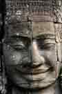
Angkor Thom : This cluster of sites is another must-see, and will again easily consume at least half a day. The spectacular South Gate is the best-preserved entry to Angkor Thom. The central temple, the Bayon, is small in scale, but bizarre, mysterious, and imaginative-the favorite of many visitors. North of the Bayon are fine friezes at the Leper King terrace.
Aerial Views : A hike up Phnom Bakheng affords fine sunset views of Angkor Wat. North of the Bayon is a hike to a hilltop behind Baphuon temple. Both hilltops give you a sense of jungle and forest vegetation.
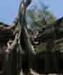
Jungle-locked Ruins : Preah Khan and Ta Prohm are romantic and spooky sites, covered by centuries of vegetation. The French left Ta Prohm untouched to give an impression of how Angkor looked in the 19th century, with tree roots and foliage winding through the stonework.
Artificial Lakes : To get an idea of the waterworks in the Angkor region, visit the ceremonial bathing sites of Neak Pean and Sra Srang or journey to the West Baray for boating or swimming.
Rural Living : Take a road in any direction from Siem Reap and you’re in the countryside. Best excursions are 13 km east to Rolous, where you can view village life, or 15 km south to Lake Tonle Sap to see floating houses waving over fish-holding pens.
Back to About Angkor / Top
ANGKOR ROUTE STRATEGIES
Angkor Archaeological Park consists of 70 ruins in an area of 200 square km, although the key ruins are clustered in a zone of some 60 square km. The French engineered routes of hard-packed earth around the Angkor area in the 1920s to facilitate visits by car. Several roads were later paved, and dubbed Le Petit Circuit (The Little Circuit) and Le Grand Circuit (the Grand Circuit), but there are really no set patterns. You can mix and match, or come up with your own routes.Start early. The heat of the day can get to you even by 09.00. Fortunately there are well-shaded sections, especially around the Bayon, and if you move along by bicycle or motorcycle you get some breeze. It’s a good idea to take a siesta in a cool spot : find a food stall selling noodles (the biggest collection of food stalls is opposite the main gates to Angkor) from 1100-1400, or just go back to town and rest. Dawn and dusk add special magic to Angkor. Angkor Wat at the break of dawn is awesome. A little later, at the Bayon, it’s misty and mysterious, with the sun filtering through the forest canopy, illuminating enigmatic smiling faces; the chirping of birds breaks the silence. The last glows of the setting sun over Angkor Wat are dramatic, viewed from either the causeway or the viewpoint of Phnom Bakheng. Then sound the frogs and cicadas, the birds and the bats. Angkor Wat is overwhelming. The mind cannot take it in at one visit. Neither will your camera-attempts to fit Angkor into a standard lens viewfinder are frustrating. Angkor can monopolize your time, consuming half a day or more. You’re better off making several visits to Angkor Wat. Drop in and walk down the causeway to get acquainted, then take off to smaller ruins up north like the Bayon, and maybe return to Angkor Wat in the late afternoon to take in a bit more.Limiting factors on routes are available time, hot spells, transportation, and road conditions. The best road conditions are found going north from Angkor Wat to Preah Khan on the northern axis, and east from Baphuon to Ta Prohm on the eastern axis. Other roads are in bad shape and potholed, slowing progress. Some ideas for routes follow, but you can chop, change, or add destinations to suit.In a car you can cover the Little Circuit in an hour of actual travel time; by bicycle, you’ll need 2.5 hours for the same route.
From the Grand Hotel to the west entrance of Angkor Wat is seven km.
For the following routes, the start and finish point in Siem Reap is the Grand Hotel.
Northern Axis : Siem Reap (Grand Hotel), Angkor Thom (South gate, Bayon, Baphuon, Leper King Terrace), Preah Khan, back south to Angkor Wat west entrance, Phnom Bakheng (sunset), Siem Reap. Distance : 29 km.
Little Circuit : Siem Reap, Angkor Wat west gate, Bayon, Victory Gate, Takeo, Ta Prohm, Sra Srang, Angkor Wat east entrance, Siem Reap. Distance : 30 km.
North and East Axis : Siem Reap, Angkor Wat west entrance, Bayon, Preah Khan, back to Leper King Terrace, Victory Gate, Chau Say Tevoda, Takeo, Ta Prohm, retrace route to Elephant Terrace, Angkor Wat again, Siem Reap. This erratic route is designed to take advantage of the best road conditions, especially if cycling. Distance : 38 km; if Preah Khan is eliminated, 32 km.
Grand Circuit : Siem Reap, Angkor Wat, Angkor Thom (South Gate, Bayon, Baphuon, Leper King Terrace), Preah Khan, Neak Pean, Sra Srang, Angkor Wat east entrance, Siem Reap. Distance : 40 km.Combination Circuit : Siem Reap, Angkor Thom (South gate, Bayon, Leper King Terrace), Preah Khan, Neak Pean, Sra Srang, Ta Prohm, Victory Gate, Elephant Terrace, Angkor Wat west entrance, Siem Reap. Distance : 45 km.
Back to About Angkor / Top
|


