To next page
Al Kharaqi 1138 (from Marw in Khorasan)
Mountaha i-idrak fi taqasim al-aflah
(The extreme knowledge about the division of the spheres)
-----------------------------------------------------------
Taken from: Youssouf KamaltomIIIfasc3
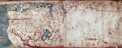
Close to the land of Habacha there is a Gulf stretching up to the Barbar it is called the gulf of Barbari. It is 500 miles long while it is 100 miles wide on one side�..among the islands in this sea are the islands of Zabadj, the islands of al-Dibadajad and Qoumr, and also the island Koulla from which lead is exported�..
It is said that the equator starts south of the lands of China, in the sea; passes by the islands of Zabag in which the land is with gold; then passes by the place that is situated between the island of Kalah; this is a port situated halfway between Oman and China- and Sribuza; it is a big island situated in the green sea, in the east. It passes then all along the southern part of Sirandib and the islands of Dibajat, north of the Zanj, in the islands, the sawahil, in the Sofala of the Zanj; north of the mountains of Komr up to when it reaches the encircling sea.