To next page
Marino Sanudo : Liber Secretorum fidelium crucis. (Book of Secrets for true Crusaders) (1320) from Italy
--------------------------------
Taken from: www.wollamshram.ca
dsal.uchicago.edu
Thomas Suarez : Early mapping of South-
east Asia
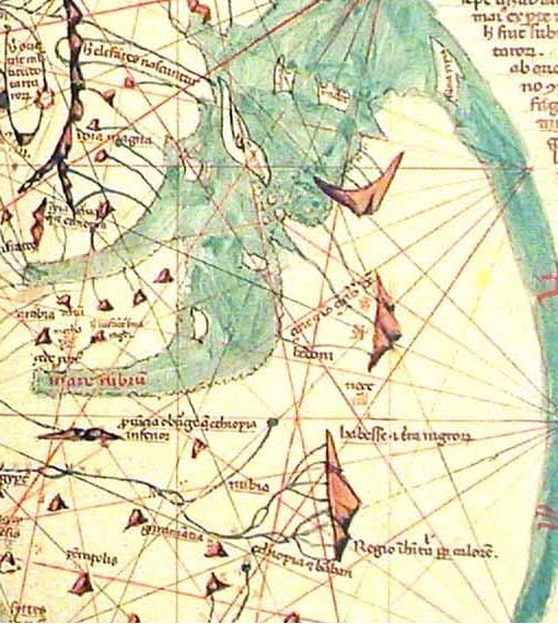
Left and under; two copies of the many extant maps of Pietro Vesconte
The world-map found in this book is clearly based on Arabic sources ; it depicts Africa in a wide truncated fashion typical of Arabic influenced maps, with a passage into the Indian Ocean of roughly 1500 km wide. There are more then 30 copies extant of this manuscript. The inscriptions for East-Africa on this map differ from one copy to the other; I will give a short overview:
ON the East African coast can be found ginger (zinziber) and nutmeg (no�a) : He connects Ginger (Zingiber) with Zinj. This is a wrong connection as the Ginger tree is from India. It never grew in East Africa. Some 16th century Portuguese however, said it grew in Madagascar and the Comoros (?).On another copy is mentioned : axiba (ariba on this copy) for Zanzibar. The Paris copy of the map has as inscriptions for Africa that do not occur on most other copies: Locaccessim; regio inhabitabilis propter calorem (This region is uninhabited because of extreme heat.) ; Habesse terra nigrorum; Nesc; Chus; Haden; Bedoni; Zinc et imo Zinziber dictur. And these last names stand in front of two towns drawn on the foot of a mountain. Never of his maps is Zanzibar an island, in fact in all cases the two towns and the inscriptions are inland.
Several of the copies of his maps have to the north of Zanzibar on the mainland an area- name called : Bedona. Easily recognizable as Idris too has a town called Bedouna north of Zanzibar.
Further north again there is a city on the coast called Haderi (not on the copy shown here) and inland indications of some other cities and Nubia placed north of the Mountains of the Moon and Habashi south.
The Red Sea is called Mare Rubrum ; a name not taken from Arab sources but from classical works. Some copies of his map show a big island at the mouth of the Persian Gulf called Kis (not on this copy) this is the island-town that took over the trade from Siraf in Persia. The crown-like island south of Zanzibar is called Nebio, a name also on Fra Mauro's map (as Nabilah) and is the Arabic word for Beautiful. One island has a forest of pepper trees, an other is inhabited by pirates, and a third is called island of Linga, dicitur Kamar. Among the islands in the Indian Ocean is one called Esfacie according to some authors this is close enough to Anfoudja of the Comoros.
If one compares his map of East Africa with the one I constructed from the coordinates given by Abulfeda one can not avoid thinking that they must have used similar sources.
On Abulfeda's map we have the Al-Kerany mountain, this mountain is also present on one version of Marino Sanido's map.
The Nile on Marino Sanudo's map is constructed in the old Ptolemian way, the branch coming from the mountains, closest to the sea is called Nile, the one furthest inland is on one copy of the map mistakenly called (on some copies) flumen Jordan (river Jordan).