To next page
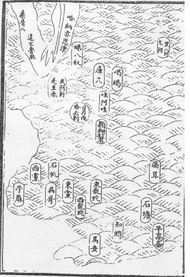
Chu Ssu-Pen (1320) (Kuang Yu T'u) (the Mongol atlas)
-----------------
Taken from: Philip Snow; The Star Raft
Neville Chittick; East Africa and the Orient
Fuchs Walter; The Mongol Atlas....
Also called Zhu Siben.
Ha-na-i-ssu-chin, which translates as ; ford of Hanais. Which might be the Arab Al-Nil-Azrak, The Blue Nile (in Abyssinian called Abai). On the west side of the continent is San-pa nu (the source of the Zanzibar slaves) and on other copies this is Sang-ku-pa this means Zanguebar (wrongly put on the west coast). Beneath this is written Zhebuluma or Che-pu-lu-ma (in the beginning of which we recognize from Arabic Djebel, mountain). In the middle of the map is written twice Sang-ku or Sanggu (from Arab Zangue or black people). Also on the east coast is an island called Ti-pa-nu (Island slaves) ( Ti-pa from diva and nu meaning slaves) and Shih-a-la t'u-li-ch'ih meaning Siela-diba being Ceylon. A small island to the south east of Africa is rendered as Ha-pi-la (Kerguelen island?)
Note: the coast of South Africa is rounded, slightly indented in the middle.
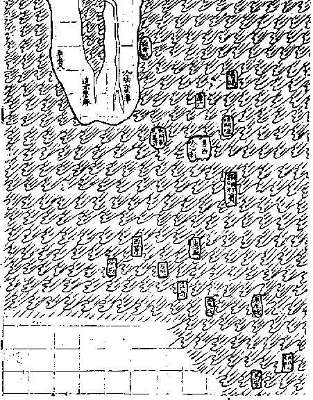
A map based on the work of two other Chinese cartographers which appeared in Korea (Ch'uan Chin and Li Hui) in 1402 even adds a stream emerging on the continent's south west coast in the approximate position of the orange river. Both maps place the southern part of Africa immediately opposite the Indonesian islands, with a string of smaller islands in between, and the tip of India tucked far away to the north. This could suggest that whoever supplied the data on Southern Africa did not get there from the Persian Gulf, by the established Muslim sailing route. But crossed from Sumatra and followed the chain of southerly islands, Maldives, Chagos and Mascarene, which stretch across the western Indian ocean at conveniently short intervals all the way to Madagascar.
There is really a good chance that this information came from Malay sailors going to their settlements in Madagascar and Africa.