 |
|||||||||
|
|
|||||||||
 |
Residential History of Portuguese Bend
|
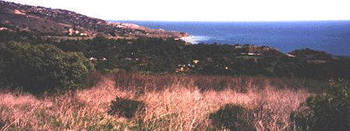
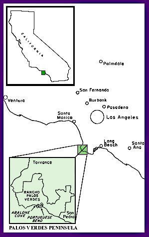 On the southwestern coast of Palos Verdes Peninsula there is an area of rolling hills, secluded coves, and particularly benign climate that has always been attractive to
those who were fortunate enough to discover it. It was apparently heavily populated by the
On the southwestern coast of Palos Verdes Peninsula there is an area of rolling hills, secluded coves, and particularly benign climate that has always been attractive to
those who were fortunate enough to discover it. It was apparently heavily populated by the
|
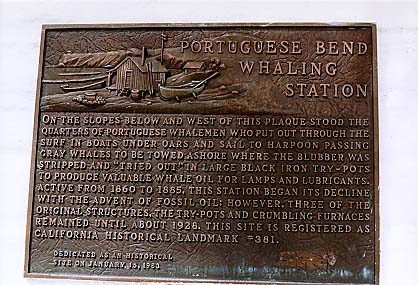
Then come the era that gave the beautiful land its name; Portuguese Bend. A group of Portuguese whalers from the Azores intrigued with offshore whaling possibilities, brought a prefabricated cabin around the horn, and settled in the cove beneath Portuguese Point. They would bring the whales caught in the channel onto the beach, where they were butchered and flayed, processing the blubber into oil in huge iron cauldrons. The stench produced by this activity hung in the air for miles, discouraging casual visitors, much less prospective residents.
Between 1874 and 1877, 2,166 barrels of oil were tried, and then the station was abandoned for lack of fuel for the rendering fires.
Around 1900, after the whalers deported, a Scandinavian fisherman by the name of Charles Lundquist moved into the cabin. Using what many believed to be the original iron rending pots, he built a flourishing business by preparing tasty 25 cent dinners for weekend patrons, consisting of fisherman, cruising yachtsmen and excursion boats from Long Beach that charged $1.50 for the round trip, including Charlie's famous fish dinner. These parties brought their own water, as Charlie' s water supply consisted of 3 huge casks that collected winter rain and served his needs all summer, developing a healthy supply of wigglers by June. Charlie's cabin, furniture and pots remained in the cove until World War II, at which time they were scrapped for salvage.
In 1905 , a yachtsman, Hugh Angleman, soiled into Portuguese Bend with his bride, to show her an area he felt was unmatched for its wild beauty and was otherwise inaccessible except by a 7-mile trail from Point Fermin. She never forgot the experience, and returned years later to make it her home.
In 1913
, Frank Vanderlip, representing a group of fifty millionaires, bought the Palos Verdes peninsula sight unseen, although he
was fully aware of its strategic location and potential for development. The plans of the
 group for the Palos Verdes project were nothing short of munificent. Mr. Vanderlip employed Dr. Ford
carpenter, a U.S. weather bureau meteorologist, to make an exhaustive study of weather conditions at various points of the peninsula. The results showed "the climate at Portuguese Bend to
be exceptionally free from extremes of either heat or cold; it is characterized by warm, balmy winters andrelatively cool summers". Based on these studies, not only did Mr. Vanderlip
decide to select this area for the location of his home, but the group made plans as well. A magnificent country club was to be erected on the bluffs above Portuguese bend, comprising 150
guest rooms, numerous dining rooms, as well as card rooms, reading rooms and locker rooms. The plans provided for a swimming
pool 60x120 foot, golf course, tennis courts, polo grounds, and a yacht club with a concrete pier.
group for the Palos Verdes project were nothing short of munificent. Mr. Vanderlip employed Dr. Ford
carpenter, a U.S. weather bureau meteorologist, to make an exhaustive study of weather conditions at various points of the peninsula. The results showed "the climate at Portuguese Bend to
be exceptionally free from extremes of either heat or cold; it is characterized by warm, balmy winters andrelatively cool summers". Based on these studies, not only did Mr. Vanderlip
decide to select this area for the location of his home, but the group made plans as well. A magnificent country club was to be erected on the bluffs above Portuguese bend, comprising 150
guest rooms, numerous dining rooms, as well as card rooms, reading rooms and locker rooms. The plans provided for a swimming
pool 60x120 foot, golf course, tennis courts, polo grounds, and a yacht club with a concrete pier.
Sketches for the main building, which was known as "Los Palos Verdes Country Club", showed an enormous rambling structure of mission design, with a multitude of towers, gables and arcades.
The dramatic dreams of Mr. Vanderlip and his friends were not destined for immediate fulfillment. By 1915 Mr. Vanderlip had demonstrated his devotion to the beauty of the peninsula by constructing a summer home on the slope above Portuguese Bend with great difficulty; as all materials and furnishings had to be transported by a narrow rutted road from San Pedro. For 7 years the "cottage", as it is still called, was the only visible fruition of the Palos Verdes project.
With the onset World War I, men's minds were occupied of with matters other than developing elaborate country estates, and by the armistice, the original members of the project had lost interest.
In a series of complicated transactions, a new syndicate was established that was to own the mass of the peninsula, and the Palos Verdes project was once more under way. With Mr. Vanderlip reserving Portuguese Bend for his own use.
During the 1920's Mr. Vanderlip developed his personal plan for a beautiful estate to center around an Italian Villa high on a knoll overlooking the sea. Thousands of trees and shrubs were planted, and the utilitarian portion of the complex was completed. A Tuscany farmhouse of the renaissance period, with stables, servants' quarters and garages, was built surrounding a courtyard. The 'farmstead', as it was named, still stands adjoining the more familiar PV stables.
In 1924 the guest house, now known as "Villa Narcissa was built and at the rear of this home, a flight of 268 stone steps bordered by Italian cypress soared to a lookout point, Where a marble temple was erected. By 1926, the road then known as Granvia La Costa was opened from Lunada Bay to Western in Miraleste.
Shortly thereafter, Mr. Harry Benedict, Frank Vanderlip' s friend and business associate, built the small elegant Villa Francesca as his part-time home just above Portuguese Point, which now stands just inside the peppertree gate. At the same time, Edward Harden, who was married to Mrs. Vanderlip's sister, constructed the lodge and gatehouse that was to lead to his elegant estate, commanding an endless vista of the sea on Portuguese Point. The Hardens also completed an expansive garage complex capable of housing is cars, and laid out walks and gardens over the 1/4 mile between Portuguese Point and Inspiration Point. The Vanderlips completed the horseshoe-shaped road with its 2 entrances on Palos Verdes Drive South, which connected all the existing buildings.
But this was as far as these palatial estates ever progressed. The Villa, which was to crown the hillside, and the estate overlooking the sea, fell victim to the depression of 1929.
With the death of Frank Vanderlip in 1937, control of the PV Corp. passed to his son Frank, and then to Harry Benedict in 1943. During this period Portuguese Bend remained open country, noted and celebrated for its rugged beauty, but uninhabited except for visits from the 3 families who built there in the 30s.
In 1945 , Kevin Vanderlip took over the Corporation, and with his wife Elin, took up residence in Villa Narcissa and resumed the development.
In 1947 5000 acres of Portuguese Bend homes were opened to the public for the first time. Roads were built, home sites were offered, and an elaborate private club was built on the site of the old whaler' s cabin. Upper" Portuguese Bend homes were to be located on the original horseshoe shaped road and would have the potential of equestrian facilities in the original
|
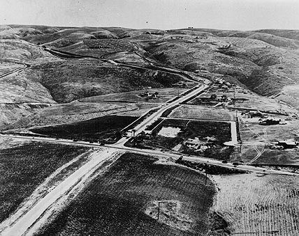 Aerial shot of the entrance to Rolling Hills
 Lest we think this precipitated an immediate increase in the density of the community, a quote from Mrs. Greg Fisher, who with her husband was leasing the harden gatehouse in 1948, said, "It is very isolated here. About 5 cars pass in a day, and after the lights go out in Malaga Cove about 10 p.m., it is totally dark."
But the community did grow quickly, and by 1950 there were 123 homes built or under construction, and the Portuguese Bend Club was the most exclusive and elegant facility of its kind for miles up and down the coast. Newspaper accounts show that parties, tournaments and organized affairs of all kinds were constant. It comprised 105 acres of land, with a 50-foot pool and 485-foot pier. Performing seals were featured in the pool at a 1950 labor day party, as well as a complete luau done by a chef brought from Hawaii.
On July 4, 1952, 25,000 to 35,000 people gathered on the slopes to see the fireworks display, which was part or a 4-day celebration; including boat races, swimming meets, firemens ball and aquacade. In late 1952 a glassed-in bar open to the sky and an ocean-water pool with its own sand beach were added. (pre-1956 photo)
It was to this community that disaster came in 1956 . The ancient landslide, which under-laid most of the area, struck without warning. On August 29th a water line ruptured. Then, within a matter of days, houses began to shift. When told to evacuate, residents couldn't or wouldn't believe it. Gaping cracks opened in living areas and sections of ceiling fell. Many residents had to be evacuated in the middle of the night; those who were determined to stick it out lost everything. About 100 homes and the club were destroyed. The ancient landslide area encompassing Portuguese Bend has been documented to show an average of 10 to 30 feet of movement per year. During this short period in 1956 the land displacement measured 68 feet.
After this tragic episode, controls have been enacted to limit the possibilities of further damage. New building is limited, land movement is constantly monitored, adjustments are continually made to roads and land, and elaborate plans for land stabilization continue to be developed and carried out because the people want to stay and to live in this wonderful small world of hills and coves and beaches, and are willing to put up with the un-certainty. "Time has altered only the surface of the terraced land. Still the proud headland thrusts out to sea. Still its incomparable vistas enthrall the hearts and minds of man. Millions of years in the making, the shape of beauty stands, separated by its towering ridge from tile hectic hurly burly of modern city life. For tens of thousands of families, it has been the promise of paradise fulfilled. And it will be for tens of thousands more. "*
Augusta Fink, Time and the Terraced Land
BIBLIOGRAPHY
· Palos Verdes Bulletin
o Vol. I #13, December, 1925
o Vol. II #4, April, 1926
o Vol. II #8, August, 1926
o Vol. V #4
· Palos Verdes Peninsula News 1922-1956
· Flexibility Study, by California State Park System on Portuguese Bend, 1971
· California1s Gabrielino Indians, Southwest Museum, Los Angeles, California
· The Palos Verdes Story - Delane Morgan
· Time and the Terraced Land Augusta Fink
· Guide of the California Hall at the Los Angeles County Museum
· San Pedro: A Pictorial History, by San Pedro Bay Historical Society
|
[Home] [History] [Directions] [Photo's] [Plot Map] [Links] Sign Guestbook View Guestbook
|
