 |
| C R O A T I A |
|
 |
 |
 |
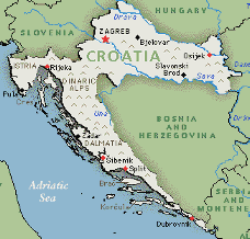
| Country's Description Croatia resembles an arc, with a long Adriatic coastline forming the western leg, and the land between the rivers Drava and Sava forming the northern leg. The capital, Zagreb, sits on the intersection of the northern and western legs of the arc. The Adriatic coastline has as many as 1,185 islands, while the 1,500-meter high Dinaric Alps run the length of the country. The Styrian Alps run north to southeast down the northern leg of Croatia, descending to the Hungarian plain in the extreme east at Osijek; much of this land is lower lying than the rest of Croatia and includes areas of marshlands. The Dalmatian coast and islands are important to future economy. The rivers in western Croatia tend to be small mountain streams. The Danube forms the eastern border with Yugoslavia (Serbia) while the other two large rivers, the Sava and Drava, form the southern and northern borders with Bosnia-Herzegovian and Hungary respectively. The land area between the rivers is dissected by many other smaller tributaries. The Adriatic coastline is the most prominent feature of Croatia. It runs the entire length of the western border, from the 430-km Istrian peninsula in the north to Dubrovnik in the south. The coast is highly indented with rocky cliffs and many small inlets. |
| Location: Europe; Southeastern Europe, bordering the Adriatic Sea, between Bosnia and Herzegovina and Slovenia Geographic coordinates: 45o 10' N, 15o 30' E Area: -total area: 56,538 sq km (21,829 sq miles) -land area: 56,410 sq km -comparative area: slightly smaller than West Virginia Land boundaries: -total: 2,073 km -border countries: Bosnia and Herzegovina 932 km, Hungary 329 km, Serbia and Montenegro 266 km (241 km with Serbia; 25 km with Montenego), Slovenia 546 km Coastline: 5,790 km (mainland 1,778 km, islands 4,012 km) Maritime claims: -continental shelf: 200-m depth or to the depth of exploitation Climate: Mediterranean and continental; continental climate predominant with hot summers and cold winters; mild winters, dry summers along coast Terrain: geographically diverse; flat plains along Hungarian border, low mountains and highlands near Adriatic coast, coastline, and islands -lowest point: Adriatic Sea 0 m -highest point: Dinara 1,830 m |
| Natural resources: oil, some coal, bauxite, low-grade iron ore, calcium, natural asphalt, silica, mica, clays, salt Environment: -current issues: air pollution (from metallurgical plants) and resulting acid rain is damaging the forests; coastal pollution from industrial and domestic waste; widespread casualties and destruction of infrastructure in border areas affected by civil strife -natural hazards: frequent and destructive earthquakes -international agreements: party to - Air Pollution, Hazardous Wastes, Marine Dumping, Nuclear Test Ban, Ozone Layer Protection, Ship Pollution, Wetlands; signed, but not ratified - Air Pollution, Biodiversity, Climate Change, Desertification, Law of the Sea Geographic note: controls most land routes from Western Europe to Aegean Sea and Turkish Straits Land use: -arable land: 32% -permanent crops: 20% -meadows and pastures: 18% -forest and woodland: 15% -other: 15% |
 |