Purpose
Students, you will collect data to make generalizations and conjectures about the location of the earth's tectonic plates while exploring the nature of earth's dynamic crust. The access to current data and instant maps in a collaborative learning environment places will place you in a simulated scientific research setting.
Description
You will access current information on earthquakes
that have recently taken place around the world. Data is collected
over a period of time (4 weeks) that, when graphed and mapped, will crudely
show the boundaries between the earth's tectonic plates. You will work in
collaborative groups, exploring various geological formations around the
world, monitoring earthquake and volcanic activity. The collection
of this information will produce generalizations and conclusions about the
changing nature of the earth.
Activities
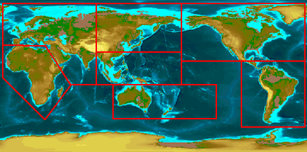
1. Groups will be assigned
with 5-7 members. Each group will be assigned a region of the world
based on tectonic boundaries. You will access the USGS Web site and
look at recent earthquake activity for your region.
2. Plot the longitude and latitude of your
region on a physiographic map.
3. Map both active and inactive volcanoes in your assigned region using the same process as in number two.
http://volcano.und.nodak.edu/volcanoes.html3. Map both active and inactive volcanoes in your assigned region using the same process as in number two.
4. What is the relationship between active
volcanoes and locations of the tectonic plates?
5. What is the relationship to earthquakes?
5. What is the relationship to earthquakes?
6. Check the sites weekly for recent data.
Compare the locations of the earthquakes with the location of the plate
tectonic boundaries.
7. Collect weekly information about your
area and study the background and effects of earthquakes. Use an Internet
search to find more information about earthquakes and volcanoes.
Look at great earthquakes of the past. When and where have they occurred? How does this information relate to tectonic activity in those areas?
page 3 go toLook at great earthquakes of the past. When and where have they occurred? How does this information relate to tectonic activity in those areas?
back to page one