9:15am
9:20am

| Geology 202 | |||||||||||||||||||||||||||||||||||||||||||||||||||||||||||||||||||||||||||||||||||||||||||||||||||||||||||||||||||||||||||||||||||||||||||||
| Road Log | |||||||||||||||||||||||||||||||||||||||||||||||||||||||||||||||||||||||||||||||||||||||||||||||||||||||||||||||||||||||||||||||||||||||||||||
| February 23, 2003 | |||||||||||||||||||||||||||||||||||||||||||||||||||||||||||||||||||||||||||||||||||||||||||||||||||||||||||||||||||||||||||||||||||||||||||||
| Mile 0 Sylvania Parking Lot 9:15am |
|||||||||||||||||||||||||||||||||||||||||||||||||||||||||||||||||||||||||||||||||||||||||||||||||||||||||||||||||||||||||||||||||||||||||||||
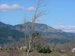
| The Sylvania campus of Portland Community College is named after Mt. Sylvania, which is a Boring Lava Vent. | |||||||||||||||||||||||||||||||||||||||||||||||||||||||||||||||||||||||||||||||||||||||||||||||||||||||||||||||||||||||||||||||||||||||||||||
| We left Sylvania taking a left on 49th Ave, which turns into Capitol Highway. The road is sloping downhill, steeper at the beginning becoming more gradual the closer we are getting to Barbur Blvd. We took a right onto Barbur Blvd the downhill slope continues to be gradual. | |||||||||||||||||||||||||||||||||||||||||||||||||||||||||||||||||||||||||||||||||||||||||||||||||||||||||||||||||||||||||||||||||||||||||||||
| Mile 2.7 7850 SW Barbur Blvd 9:20am |
|||||||||||||||||||||||||||||||||||||||||||||||||||||||||||||||||||||||||||||||||||||||||||||||||||||||||||||||||||||||||||||||||||||||||||||
| Terwilliger Parkway | |||||||||||||||||||||||||||||||||||||||||||||||||||||||||||||||||||||||||||||||||||||||||||||||||||||||||||||||||||||||||||||||||||||||||||||
| 1996 flooding created a landslide that crossed Barbur Blvd. In order to protect the houses that are built at the top of the landslide area, a concrete retaining wall was built. Steel rods have been set back approximately 50 feet to be lodged into rocks, in order to create a stable retaining wall, which will hold back the Portland Hill Silt in another flooding episode. | |||||||||||||||||||||||||||||||||||||||||||||||||||||||||||||||||||||||||||||||||||||||||||||||||||||||||||||||||||||||||||||||||||||||||||||
|
|||||||||||||||||||||||||||||||||||||||||||||||||||||||||||||||||||||||||||||||||||||||||||||||||||||||||||||||||||||||||||||||||||||||||||||
| Retaining wall showing Apartment Building | |||||||||||||||||||||||||||||||||||||||||||||||||||||||||||||||||||||||||||||||||||||||||||||||||||||||||||||||||||||||||||||||||||||||||||||
| High quantities of rainfall are not the only contributing factors to this landslide. The steeping of the slope in order to create a level surface to build Barbur Blvd weakened the resisting forces within the hillside. City of Portland government has been encouraging business and residents to disconnect their downspouts in order to lessen the impact of rainwater in the city's storm water drains, which are connected to the city's sewer system. This causes raw sewage to overflow into the Willamette River during high rainfall systems. Disconnecting the downspouts would have added to the water runoff within the hillside. | |||||||||||||||||||||||||||||||||||||||||||||||||||||||||||||||||||||||||||||||||||||||||||||||||||||||||||||||||||||||||||||||||||||||||||||
|
|||||||||||||||||||||||||||||||||||||||||||||||||||||||||||||||||||||||||||||||||||||||||||||||||||||||||||||||||||||||||||||||||||||||||||||
| Drainage system created within the retaining wall | |||||||||||||||||||||||||||||||||||||||||||||||||||||||||||||||||||||||||||||||||||||||||||||||||||||||||||||||||||||||||||||||||||||||||||||
| Water is one of the main contributing factors in landslide. Small amounts of water create an initial cohesiveness of loose material but excessive water promotes slope failure by reducing friction. "Excessive water... can promote slope failure by reducing friction... between surface materials and underlying rocks, between adjacent grains of unconsolidated sediment..., or even between adjacent rock masses that are separated by a plane of weakness." (Chernicoff:222) | |||||||||||||||||||||||||||||||||||||||||||||||||||||||||||||||||||||||||||||||||||||||||||||||||||||||||||||||||||||||||||||||||||||||||||||
| We continued along Barbur Blvd taking a left onto Terwilliger Blvd. Terwilliger is a very meandering road. The roads gradient increases as we travel downhill. Trees of all different types line either side of the roadway with intermittent breaks between younger and mature vegetation. | |||||||||||||||||||||||||||||||||||||||||||||||||||||||||||||||||||||||||||||||||||||||||||||||||||||||||||||||||||||||||||||||||||||||||||||
| George Himes Park | |||||||||||||||||||||||||||||||||||||||||||||||||||||||||||||||||||||||||||||||||||||||||||||||||||||||||||||||||||||||||||||||||||||||||||||
| The Willamette River is a meandering stream. Ross Island, Hardtack Island and East Island are all channel bars, which were created through sediment deposited within a river channel. The swifter currents and a narrower river channel carried these sediments downstream. After the Willamette passes under the Sellwood Bridge the river channel widens and the stream velocity drops. The city has armored the banks of the Willamette River by building concrete sea walls and by rip rapping the edges of the river channel. | |||||||||||||||||||||||||||||||||||||||||||||||||||||||||||||||||||||||||||||||||||||||||||||||||||||||||||||||||||||||||||||||||||||||||||||
| Willamette River watershed/drainage basin covers 11,000 sq. mi. from the Cascade Mountains to the Pacific coast range. The Willamette River drainage basin drains in to the Columbia River. The Willamette River is made up of several different sub-basins that all flow directly into the Willamette. | |||||||||||||||||||||||||||||||||||||||||||||||||||||||||||||||||||||||||||||||||||||||||||||||||||||||||||||||||||||||||||||||||||||||||||||
|
|||||||||||||||||||||||||||||||||||||||||||||||||||||||||||||||||||||||||||||||||||||||||||||||||||||||||||||||||||||||||||||||||||||||||||||
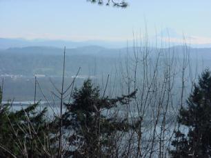
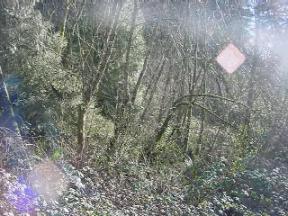
| Willamette River seen through the trees | |||||||||||||||||||||||||||||||||||||||||||||||||||||||||||||||||||||||||||||||||||||||||||||||||||||||||||||||||||||||||||||||||||||||||||||
|
|||||||||||||||||||||||||||||||||||||||||||||||||||||||||||||||||||||||||||||||||||||||||||||||||||||||||||||||||||||||||||||||||||||||||||||
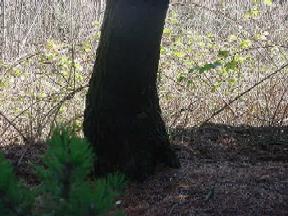
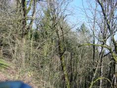
| Pistol Butt Tree | |||||||||||||||||||||||||||||||||||||||||||||||||||||||||||||||||||||||||||||||||||||||||||||||||||||||||||||||||||||||||||||||||||||||||||||
| Pistol Butt trees indicate that the hillside they are growing in has moved. Evergreen trees are the best indicators because they always try to grow upwards. Red Alder, Cottonwood trees grow towards the sun, therefore, they will not be indicative of a moving hillside. | |||||||||||||||||||||||||||||||||||||||||||||||||||||||||||||||||||||||||||||||||||||||||||||||||||||||||||||||||||||||||||||||||||||||||||||
| George Himes Park | |||||||||||||||||||||||||||||||||||||||||||||||||||||||||||||||||||||||||||||||||||||||||||||||||||||||||||||||||||||||||||||||||||||||||||||
| The hillside is steeper than 1:1 gradient with an approximate 48� angle. The absence of mature Evergreen trees could be indicative of landslide activity. In the 1920s - 1930s, the City of Portland built ten to fifteen adits to drain rain runoff from the hillside. These adits are built using wood timbers to frame horizontal drains that are approximately 4' X 5'. | |||||||||||||||||||||||||||||||||||||||||||||||||||||||||||||||||||||||||||||||||||||||||||||||||||||||||||||||||||||||||||||||||||||||||||||
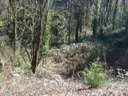
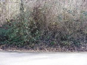
| Areas of sparse vegetation surrounded by areas of vast vegetation are indicative of past land movement. Plants such as berry bushes have root systems that do not infiltrate the soil deep enough to create a more stable surface. | |||||||||||||||||||||||||||||||||||||||||||||||||||||||||||||||||||||||||||||||||||||||||||||||||||||||||||||||||||||||||||||||||||||||||||||
|
|||||||||||||||||||||||||||||||||||||||||||||||||||||||||||||||||||||||||||||||||||||||||||||||||||||||||||||||||||||||||||||||||||||||||||||
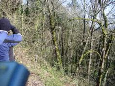
| Terwilliger Blvd Landslide | |||||||||||||||||||||||||||||||||||||||||||||||||||||||||||||||||||||||||||||||||||||||||||||||||||||||||||||||||||||||||||||||||||||||||||||
| Alder trees grow towards the sun so they are not a good indicator of land movement, but the Alder tree pictured below has shifted with the movement and does indicate a history of land movement. | |||||||||||||||||||||||||||||||||||||||||||||||||||||||||||||||||||||||||||||||||||||||||||||||||||||||||||||||||||||||||||||||||||||||||||||
|
|||||||||||||||||||||||||||||||||||||||||||||||||||||||||||||||||||||||||||||||||||||||||||||||||||||||||||||||||||||||||||||||||||||||||||||
|
|||||||||||||||||||||||||||||||||||||||||||||||||||||||||||||||||||||||||||||||||||||||||||||||||||||||||||||||||||||||||||||||||||||||||||||
| Shifted Alder Tree | |||||||||||||||||||||||||||||||||||||||||||||||||||||||||||||||||||||||||||||||||||||||||||||||||||||||||||||||||||||||||||||||||||||||||||||
| George Himes Park | |||||||||||||||||||||||||||||||||||||||||||||||||||||||||||||||||||||||||||||||||||||||||||||||||||||||||||||||||||||||||||||||||||||||||||||
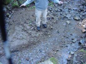
| This stream has a 10:1 gradient. This stream is a part of the Willamette Drainage Basin. This stream, while it was low in the stream bank will rise with the rainwater runoff. A culvert has been created to allow the stream to drain under Terwilliger Blvd. During times of high water runoff, the culvert will not be able to handle all the water and the stream will overflow its banks.; At this point Terwilliger Blvd will act as a dam and hold back the water. If Terwilliger fails, not only could the road wash out but also it could be carried downhill in a landslide. | |||||||||||||||||||||||||||||||||||||||||||||||||||||||||||||||||||||||||||||||||||||||||||||||||||||||||||||||||||||||||||||||||||||||||||||
|
|||||||||||||||||||||||||||||||||||||||||||||||||||||||||||||||||||||||||||||||||||||||||||||||||||||||||||||||||||||||||||||||||||||||||||||
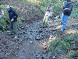
| First Order Stream | |||||||||||||||||||||||||||||||||||||||||||||||||||||||||||||||||||||||||||||||||||||||||||||||||||||||||||||||||||||||||||||||||||||||||||||
|
|||||||||||||||||||||||||||||||||||||||||||||||||||||||||||||||||||||||||||||||||||||||||||||||||||||||||||||||||||||||||||||||||||||||||||||
|
|||||||||||||||||||||||||||||||||||||||||||||||||||||||||||||||||||||||||||||||||||||||||||||||||||||||||||||||||||||||||||||||||||||||||||||
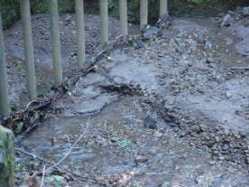
| This shows a point bar Undercutting of the Point Bar | |||||||||||||||||||||||||||||||||||||||||||||||||||||||||||||||||||||||||||||||||||||||||||||||||||||||||||||||||||||||||||||||||||||||||||||
| This stream is a braided stream that was created through the depositing of sediment. Water flows through the path of least resistance. When sediment builds up it forms a dam that the water finds a way to flow around, this creates separate water flows within the same stream. | |||||||||||||||||||||||||||||||||||||||||||||||||||||||||||||||||||||||||||||||||||||||||||||||||||||||||||||||||||||||||||||||||||||||||||||
| We are now leaving George Hines Park. We traveled through downtown Portland until we reached Burnside Blvd. After climbing in altitude, we turned right onto Skyline Blvd. On this drive, we passed a hillside that showed scarring from a rockslide. The hillside has had some mesh draped on it in order to prevent any rocks from falling into the roadway. | |||||||||||||||||||||||||||||||||||||||||||||||||||||||||||||||||||||||||||||||||||||||||||||||||||||||||||||||||||||||||||||||||||||||||||||
| This landslide is a rotational slump. The Alder trees are growing in several different directions. There is a huge Alder tree at the toe of the slump. This landslide happened in 1996 along with quite a few others in Oregon. That winter had above average snow pack in both the Pacific Coastal Mountain Range and the Cascade Mountain Range. In early February 1996 warm, wet weather infiltrated the region causing part of the snow pack to melt. The combination of heavy rains and runoff from melting snow destabilized many hillsides. | |||||||||||||||||||||||||||||||||||||||||||||||||||||||||||||||||||||||||||||||||||||||||||||||||||||||||||||||||||||||||||||||||||||||||||||
|
|||||||||||||||||||||||||||||||||||||||||||||||||||||||||||||||||||||||||||||||||||||||||||||||||||||||||||||||||||||||||||||||||||||||||||||
|
|||||||||||||||||||||||||||||||||||||||||||||||||||||||||||||||||||||||||||||||||||||||||||||||||||||||||||||||||||||||||||||||||||||||||||||
| Alder Tree Growth Alder Tree Growth | |||||||||||||||||||||||||||||||||||||||||||||||||||||||||||||||||||||||||||||||||||||||||||||||||||||||||||||||||||||||||||||||||||||||||||||
| We left the city of Portland and traveled east on Intestate 84 for 35 miles.Interstate 84 follows the banks of the Columbia River. Over time, the Columbia River has eroded its path by down cutting through Columbia River Basalt flows (13 to 15 mya) and Andesite (2 to 5 mya). | |||||||||||||||||||||||||||||||||||||||||||||||||||||||||||||||||||||||||||||||||||||||||||||||||||||||||||||||||||||||||||||||||||||||||||||
| We stopped at the western lobe of the Dodson Debris Flow. The flow has four different lobes.The debris flow happened on February 8, 1996. The debris flowed at an estimated 30 miles per hour on the eastern edge but at a slow pace of about 5 miles per hour on the western edge. The debris buried the first floor of the Carol and Hersh Royse house. The debris crossed over Interstate 84 and the railroad tracks closing the highway for three weeks | |||||||||||||||||||||||||||||||||||||||||||||||||||||||||||||||||||||||||||||||||||||||||||||||||||||||||||||||||||||||||||||||||||||||||||||
| One of the Dodson residents reported that the Tumult Creek stopped flowing before the debris flow. This stoppage was probably created by debris blocking the flow upstream which created a dam that was breached on February 8.The estimated volume of debris deposits ranges from 1 million to 2.5 million cubic yards. | |||||||||||||||||||||||||||||||||||||||||||||||||||||||||||||||||||||||||||||||||||||||||||||||||||||||||||||||||||||||||||||||||||||||||||||
| This debris flow is not the first in this area. Previous flows have happened in 1918 (about as big as 1996), 1964, 1972 and 1975. A small debris flow happened in January 1997, but it stayed with in the channel. This area has now been labeled a geologic hazard zone and the Royse's are not allowed to rebuild their house. | |||||||||||||||||||||||||||||||||||||||||||||||||||||||||||||||||||||||||||||||||||||||||||||||||||||||||||||||||||||||||||||||||||||||||||||
|
|
||||||||||||||||||||||||||||||||||||||||||||||||||||||||||||||||||||||||||||||||||||||||||||||||||||||||||||||||||||||||||||||||||||||||||||
| Possible Sources for the Dobson Debris Flow | |||||||||||||||||||||||||||||||||||||||||||||||||||||||||||||||||||||||||||||||||||||||||||||||||||||||||||||||||||||||||||||||||||||||||||||
|
|||||||||||||||||||||||||||||||||||||||||||||||||||||||||||||||||||||||||||||||||||||||||||||||||||||||||||||||||||||||||||||||||||||||||||||
| This is for a reference for the upper two pictures | |||||||||||||||||||||||||||||||||||||||||||||||||||||||||||||||||||||||||||||||||||||||||||||||||||||||||||||||||||||||||||||||||||||||||||||
| In this debris flow, as well as with most debris flows, the debris consists of poorly sorted materials. The flow gathers up different size particles and deposits them together. The Missoula Floods that created the Columbia River Gorge approximately 12,700 years ago originally deposited some of this debris. | |||||||||||||||||||||||||||||||||||||||||||||||||||||||||||||||||||||||||||||||||||||||||||||||||||||||||||||||||||||||||||||||||||||||||||||
|
|
||||||||||||||||||||||||||||||||||||||||||||||||||||||||||||||||||||||||||||||||||||||||||||||||||||||||||||||||||||||||||||||||||||||||||||
| This is the debris flow deposit. This shows the different particle sizes. | |||||||||||||||||||||||||||||||||||||||||||||||||||||||||||||||||||||||||||||||||||||||||||||||||||||||||||||||||||||||||||||||||||||||||||||
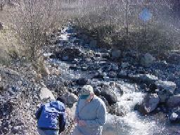
| This stream was formed because of the Dodson debris flow. In this poorly sorted streambed, we were able to find samples of different rocks. Sample 1 is Diktytaxitic, a basalt flow rock. Sample 2 is Cascade Andesite. Sample 3 is Columbia River Basalt. | |||||||||||||||||||||||||||||||||||||||||||||||||||||||||||||||||||||||||||||||||||||||||||||||||||||||||||||||||||||||||||||||||||||||||||||
|
|||||||||||||||||||||||||||||||||||||||||||||||||||||||||||||||||||||||||||||||||||||||||||||||||||||||||||||||||||||||||||||||||||||||||||||
| Dodson Stream | |||||||||||||||||||||||||||||||||||||||||||||||||||||||||||||||||||||||||||||||||||||||||||||||||||||||||||||||||||||||||||||||||||||||||||||
| The Columbia River has a low gradient. It rarely has overflowed its channel; therefore, it does not have a lot of flood plain along its banks. In the past few decades, several dams have been built on the river. The riverbanks have been shored up by mean of armoring with concrete and rip rap. | |||||||||||||||||||||||||||||||||||||||||||||||||||||||||||||||||||||||||||||||||||||||||||||||||||||||||||||||||||||||||||||||||||||||||||||
|
|||||||||||||||||||||||||||||||||||||||||||||||||||||||||||||||||||||||||||||||||||||||||||||||||||||||||||||||||||||||||||||||||||||||||||||
|
|||||||||||||||||||||||||||||||||||||||||||||||||||||||||||||||||||||||||||||||||||||||||||||||||||||||||||||||||||||||||||||||||||||||||||||
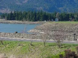
| Rip Rap in the Columbia River Concrete Wall at Bonneville Dam | |||||||||||||||||||||||||||||||||||||||||||||||||||||||||||||||||||||||||||||||||||||||||||||||||||||||||||||||||||||||||||||||||||||||||||||
| When the Bonneville dam was built the well for the fish hatchery had to be re-sited. It took several tries to find another spot that could deliver water that was suitable for the hatchery fish. | |||||||||||||||||||||||||||||||||||||||||||||||||||||||||||||||||||||||||||||||||||||||||||||||||||||||||||||||||||||||||||||||||||||||||||||
|
|||||||||||||||||||||||||||||||||||||||||||||||||||||||||||||||||||||||||||||||||||||||||||||||||||||||||||||||||||||||||||||||||||||||||||||
|
|||||||||||||||||||||||||||||||||||||||||||||||||||||||||||||||||||||||||||||||||||||||||||||||||||||||||||||||||||||||||||||||||||||||||||||
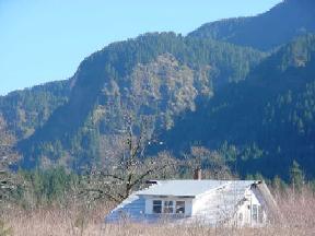
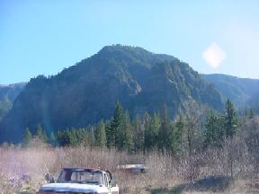
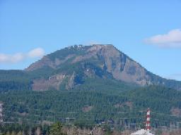
| Wind Mountain is where the Bonneville slide started. The scars are still present | |||||||||||||||||||||||||||||||||||||||||||||||||||||||||||||||||||||||||||||||||||||||||||||||||||||||||||||||||||||||||||||||||||||||||||||
| The Bonneville landslide covered more than 5 1/2 sq. miles. It started on the southern side of the Columbia River Gorge on Wind Mountain. It flowed south across the Columbia River and up the southern side of the gorge. The initiating event is not known but an earthquake or a rock failure could have triggered it. | |||||||||||||||||||||||||||||||||||||||||||||||||||||||||||||||||||||||||||||||||||||||||||||||||||||||||||||||||||||||||||||||||||||||||||||
| Scientists are still trying to figure out when the Bonneville slide happened. It is thought that the landslide might have coincided with a tsunami that happened across the Pacific Ocean about 700 years ago, but using radiocarbon dating is pointing to a more recent time period. | |||||||||||||||||||||||||||||||||||||||||||||||||||||||||||||||||||||||||||||||||||||||||||||||||||||||||||||||||||||||||||||||||||||||||||||
| http://sarvis.dogami.state.or.us/Landslide/O0205.pdf | |||||||||||||||||||||||||||||||||||||||||||||||||||||||||||||||||||||||||||||||||||||||||||||||||||||||||||||||||||||||||||||||||||||||||||||
| http://www.geol.pdx.edu/people/kmc/projects/dodson/photogallery-deposit.html | |||||||||||||||||||||||||||||||||||||||||||||||||||||||||||||||||||||||||||||||||||||||||||||||||||||||||||||||||||||||||||||||||||||||||||||
| http://www.geol.pdx.edu/people/kmc/projects/dodson/flowmaps.html | |||||||||||||||||||||||||||||||||||||||||||||||||||||||||||||||||||||||||||||||||||||||||||||||||||||||||||||||||||||||||||||||||||||||||||||
| http://www.geol.pdx.edu/people/kmc/projects/dodson/2001_flow/default.html | |||||||||||||||||||||||||||||||||||||||||||||||||||||||||||||||||||||||||||||||||||||||||||||||||||||||||||||||||||||||||||||||||||||||||||||
| http://www.geol.pdx.edu/people/kmc/projects/dodson/photogallery-source.html | |||||||||||||||||||||||||||||||||||||||||||||||||||||||||||||||||||||||||||||||||||||||||||||||||||||||||||||||||||||||||||||||||||||||||||||
| http://spot.pcc.edu/~mhutson/gorge/main.html | |||||||||||||||||||||||||||||||||||||||||||||||||||||||||||||||||||||||||||||||||||||||||||||||||||||||||||||||||||||||||||||||||||||||||||||
| Return to School Page | |||||||||||||||||||||||||||||||||||||||||||||||||||||||||||||||||||||||||||||||||||||||||||||||||||||||||||||||||||||||||||||||||||||||||||||
| Return to Home Page | |||||||||||||||||||||||||||||||||||||||||||||||||||||||||||||||||||||||||||||||||||||||||||||||||||||||||||||||||||||||||||||||||||||||||||||