| Antarctica - Nuggies On Ice |
| [ Home > Other Pages > Radio Repeaters ] |
| Antarctica New Zealand
provides a VHF radio network for the use of field research personnel. They also maintain HF transmit and
receive facilities for field researchers outside VHF coverage. Because of the extreme cold during the winter
down here, the radio equipment is installed and recovered each season. At the beginning of October, the
equipment is installed and at the beginning of February, when the field personnel no longer need the
service, it is all recovered. This involves a lot of helicopter hours and covers at least 3 days work at
each end of the summer science season. The VHF radio repeaters are installed at Hoopers Shoulder, (which is just over halfway up the western slope of Mt.Erebus), Mt.Newall, (near the eastern end of the Asgard Range between the Wright and Taylor Valleys), Mt.J.J.Thompson, (near the western end of the same range), Mt.Cerberus, (near the middle of the Olympus Range between the Wright and Victoria Valleys) and Crater Hill, (immediately north of Scott Base). There is an HF receiver station near Scallop Hill on the eastern end of Black Island, (40 kilometres south of Scott Base). Sites were chosen because they were relatively snow-free, so that any snow build-up caused by the installations is kept to a minimum. This in turn allows for ease of access. At each site the power supply is provided by gel-cell batteries that are charged by solar panels through a voltage regulator. Solar panels are mounted on the sides and rooves of the repeater huts or boxes. They are placed to maximise available sunlight. Each of the batteries weighs approximately 35 kilograms and they become extremely hard to carry at the altitude of the repeater sites. The major sites at Hoopers Shoulder and Black Island involve about 400 kilograms of equipment and often take hours to install or recover. |
| Hoopers Shoulder VHF Repeater |
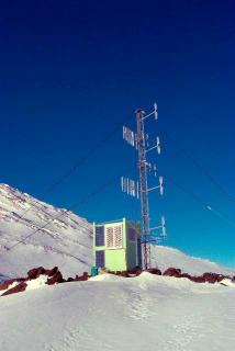
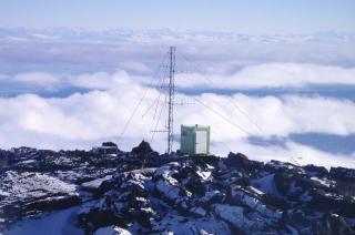
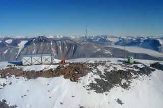
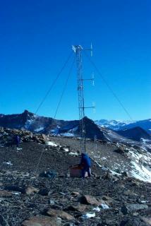
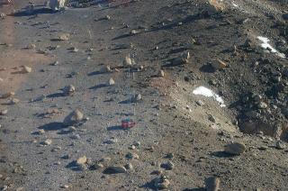
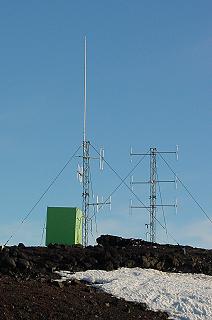
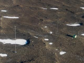
| Each season, the first repeater to be installed and the last to be removed is at Hoopers Shoulder. The repeater site is on a small lava flow at an altitude of approximately 2000 metres. Why such a site would have a name I do not know, as it looks very much like every other lava flow in the vicinity. The repeater site can just be seen in the picture, (below right). This repeater is very important because, as well as providing a radio channel for use in the McMurdo Sound area, it provides the UHF radio links between Scott Base and repeaters in the Dry Valleys. It also provides VHF telephone links to the Italian base at Terranova Bay, 300 kilometres further north. This enables the Italians to make and receive calls through the Ross Island Telephone System provided by Telecom New Zealand. |
| On a good day, Hoopers Shoulder is a pretty nice place to work. At the beginning of the season, the sun does not climb over the ridge to the north until about 10.30am. Until then, it is quite cold at the repeater site. Normally the first few hours at the site are taken up with moving the equipment from the helicopter landing site to the repeater hut. With no wind blowing, conditions are reasonably pleasant, |
| but if the wind starts blowing it becomes bitterly cold. If that happens a lot of time is spent trying to stay warm and the job seems to go on for ever. |
| At the beginning of one summer season, we arrived at Hoopers Shoulder. The weather was fine, but with a temperature of -35 degrees Celsius. That itself would have been |
| tolerable, but we had work to do up the antenna tower. Within a few hours the wind was blowing over 30 knots and this provided a wind chill of -65 degrees Celsius. At that sort of temperature work was impossible and we had to be brought off the mountain without completing the work. The next day we were back, but with the same result. Finally, on the third day, we completed the work. |
| When working at Hoopers
Shoulder, it is wise to keep an eye on approaching cloud. On my first visit there, in 1996, cloud blanketed
the whole Ross Island area between sea level and Hoopers Shoulder. This meant that the helicopter could not
pick us up from the mountain. We ended up spending the night at the repeater site. If nothing else it taught
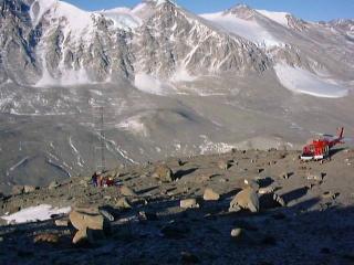
me to watch the weather. It also taught me that the sun in Antarctica is quite warm at 11.30pm. At the other end of the season the problem becomes more critical. The helicopters need to be winterised and stored in the hangar at McMurdo. Because of this there is more urgency to get off the mountain. The picture, (above left), shows cloud over McMurdo Sound at the end of the 2003-2004 season. We had just enough time to get the equipment into the helicopter before cloud rolled over the site. We took off to the north and found a hole through the cloud that allowed us to descend towards sea level and then back to Scott Base. However, on my many trips to the repeaters in the Dry Valleys, I have never encountered bad weather. There has sometimes been wind and sometimes high cloud, but we have always been able to complete our work in short time frames. This makes for a very pleasant working day. |
 |
 |
 |
 |
| Mt.Newall VHF Repeater |
| The Mt.Newall repeater provides coverage the length of the Wright Valley and out into parts of McMurdo Sound, as far as Cape Bird, on the northern tip of Ross Island, and Bratina Island to the south, at the tip of the Brown Peninsula. This repeater is the next to be installed, following Hoopers Shoulder. The main reason for this being that the Wright Valley and the hut at Cape Bird are often the first locations our scientists visit during the season. |
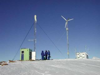
| Situated at an altitude of approximately 1800 metres on a long, narrow ridge to the west of the peak of Mt.Newall, our tiny green repeater hut is relatively easy to find. As can be seen in the pictures on the left, this is mainly because of the large steel building alongside. This houses the American repeater equipment and the United States Geological Survey radio equipment linking the seismic monitoring station at Bull Pass to McMurdo Station. With a large wind- powered generator and diesel back-up, their facility operates year round. |
| Because this site is about 100 kilometres from Scott Base and the helicopter has been carrying about 300 kilograms of equipment as well as us, we are normally left here to complete our work. Meanwhile the helicopter travels to the Marble Point refuelling depot to take on enough fuel to complete the rest of our installations, before returning to pick us up. |
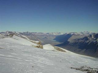
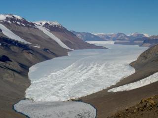
| Like all our repeater
sites, the views are quite spectacular. As well as good views of McMurdo Sound and Ross Island, the whole of
the upper Wright Valley can be seen with the East Antarctic ice sheet beyond. The picture, on the right
above, shows the view of the valley. In the centre of this view is Lake Vanda, where Antarctica New Zealand
once manned a year-round station, but now have only a group of emergency huts. There is a certain amount of security in having the large American building alongside. If we ever had to be left at Mt.Newall because of bad weather, there is quite a large survival cache in the building and it is very warm inside. Anybody left at this site would be well protected until they could be picked up. |
 |
 |
 |
| Mt.Cerberus VHF Repeater |
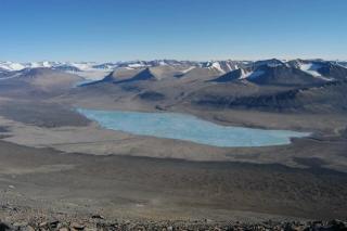
| Situated approximately 1500 metres up the northern slope of Mt.Cerberus is the repeater that covers the Victoria Valley, the McKelvey Valley and parts of McMurdo Sound. Overlooking Lake Vida, the whole of the Victoria Valley is visible from this site. Seen in the picture, below left, Lake Vida is the deepest of the lakes in the Dry Valleys and is over 380 metres deep. While frozen at the surface, the lake is liquid below a thick ice cover. |
| At this site the radio equipment is housed in a multi-ply plywood box. Two solar panels are mounted on the removable lid of the box to catch sun for most of the 24 hours. The box is held in place by heavy duty cargo strops placed around the box and the adjacent antenna tower. The antenna tower is the same construction as those installed at Hoopers Shoulder and Mt.Newall. It is anchored at three locations spaced around the tower. |
| For all the techos out there; on the 9-metre tall, steel lattice tower is a phased array of four, folded-dipole antennas, (for the VHF repeater), and one multi-element yagi aimed at Hoopers Shoulder, (for the UHF linking network). Using this repeater, or any of the |
| others in the Dry Valleys, triggers all Dry Valleys repeaters to form a very large coverage area of approximately 11250 square kilometres. More than half of the summer science programmes utilise the radio channel operating in the Dry Valleys during the summer season, so it gets quite a bit of use. |
 |
 |
| Mt.J.J.Thompson VHF Repeater |
| Normally the last of the Dry Valleys repeaters to be installed, (because it is on the way back to Scott Base), the repeater at Mt.J.J.Thompson is quite often in the shade from the mountain when we get there. Providing there is no wind, this is not a problem, but the lack of direct sun makes it difficult to check that the solar panel regulator is actually working. Because of this shadow for most of the afternoon, an extra solar panel is installed here. |
| Overlooking Lake Bonney, the repeater covers the Taylor Valley and, due to gaps in the Kukri Hills on the south side of the valley, coverage extends to Table Mountain. Like the repeater at Mt.Cerberus, this repeater is situated on a narrow ledge approximately 1500 metres above the valley floor. The picture on the right shows just how hard it is to see the repeater installation from the helicopter. To give an idea of scale, the antenna tower is again 9 metres tall and the large rock to the left of the installation is about 2 metres tall. |
| Of all the repeater sites, this one is the most difficult for helicopter landings, since the whole ledge is covered with large boulders that make picking a safe landing spot very hard. Wind speed and direction become very important indeed. The rest of the ledge is covered in loose gravel, so these boulders come in useful as anchor points for the antenna tower |
| The picture, above
left, is a view looking towards the repeater site sitting on the edge of a very steep drop to the valley
floor. The scenery in the Taylor Valley looks a lot more rugged than the other valleys. The terrain in the
valley also means that coverage does not extend to all areas as it does at the other repeater
sites. Below the repeater is Lake Bonney, one of the shallower lakes in the Dry Valleys. The main source for the lake is the meltwater from the Taylor Glacier that runs during summer. In the picture, above right, can be seen a small part of Lake Bonney and the Taylor Glacier. The East Antarctic polar plateau is less than 30 kilometres away, up the valley. To the right of the glacier face is Blood Falls, a peculiar iron oxide deposit picked up by the glacier. |
 |
 |
 |
| Crater Hill VHF Repeater |
| Crater Hill repeater is located, strangely enough, on Crater Hill, a small volcanic cone about a kilometre north of Scott Base. This repeater site is used for the VHF channel covering the local Scott Base area. It is also used for other channels, such as paging, aviation and American channel access. The third use is to house the equipment used to trigger the Hoopers Shoulder repeater and, (in an emergency), the Dry Valleys repeaters. |
| The picture on the left
shows the repeater site. There are two antenna towers here, to accommodate the extra antennas required for
all of the extra services provided. The main VHF channel provided is connected to the large, white, vertical
antenna on the top of the left-hand tower, thereby providing 360 degree coverage. Unfortunately, because of natural obstacles and the requirement for VHF communications to be line-of-sight, the actual coverage is not as good, but includes a lot of McMurdo Sound, the Ross Ice Shelf and parts of Ross Island beyond the immediate Scott Base area. |
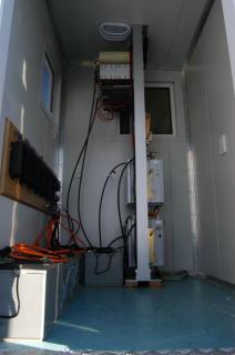
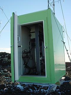
| It is the only one of our repeaters that is left in service year round. The reason for this is its close proximity to Scott Base. We are able to use the generator mains supply from Scott Base to power the site. The power supply on site is still a regulated 12-volt supply, but using mains-powered rectifiers to float the batteries, instead of the solar panels used at other sites. The mains power also allows a small amount of heating to be provided in winter to keep the temperature inside the hut above freezing. One downside to the installation on Crater Hill is that the hut is rather full, as can be seen in the picture, (top right). This does not leave much room to work inside the hut, especially in winter when wearing cold weather clothing. |
| The repeaters and
triggers are connected by copper cable to Scott Base. The copper cable also allows us to provide VHF radio
telephone circuits, if needed, and there is a certain amount of comfort in having a standard telephone
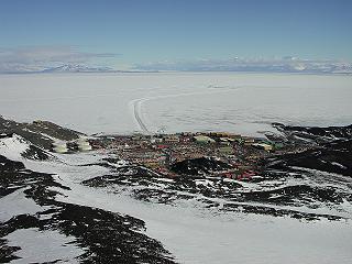
equipped in the hut, for emergencies. Being close to Scott Base and within easy walking distance means that Crater Hill is easily accessible. While the peak is only 330 metres above sea level, the views from the top are quite stunning. The picture, (lower right), shows the view towards the south-west. In the foreground is McMurdo Station, in the middle distance is the airfield on the sea ice and in the distance are the end of the Brown Peninsula, (on the left), and the Royal Society Range, (part of the Trans-Antarctic Mountains, on the right). |
 |
 |
 |
| Black Island HF Receiver Station |
| Because HF radio does not rely on line-of-sight transmission, the HF receiver site on Black Island is at sea level in a spot sheltered from most of the strong southerly winds. Once again a snow-free area was chosen, not that the snow stays long on the ground because of the wind. An HF receiver remote from Scott Base is necessary because of the often weak signals involved and the large amount of radio noise near Scott Base. |
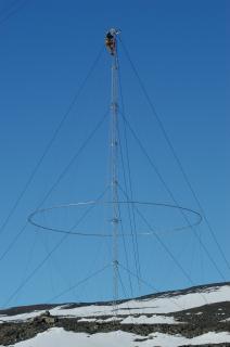
| The picture on the left shows the site viewed from an approaching helicopter. The two large antenna masts for HF can be seen on the left and middle right. The equipment hut and the UHF antenna mast, (for relaying the received signals to Scott Base and receiving control signals), can be seen on the right. The left-hand HF mast is for a conical monopole antenna and the right-hand one is for a delta antenna. Both of the large towers are 25 metres high. On the right is a view of work being done on the conical monopole antenna. Due to the |
| fact that there are very strong winds whenever there is a blizzard, constant checks have to be made on the rigging supporting the towers and also the elements of the antenna. |
| In 2003 the whole antenna had to be lowered to enable replacement of hardware that had failed due to the harsh conditions. Refurbishment of the antenna took two days to complete and hopefully will last for a few more years. |
| The delta antenna does not seem to suffer any damage at all and normally only requires a check to confirm this. |
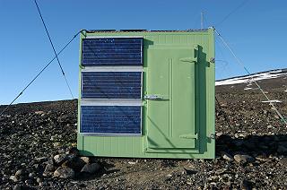
| The hut at the site is larger than any of the others, mainly due to the site being at sea level and therefore allowing more weight to be carried by helicopter. Like all the huts, it is anchored to the ground with wire cables on all four corners. At the moment there are nine solar panels mounted on the hut - the three seen on the north-facing wall and six more on the roof. |
| Strong winds coupled
with the volcanic rubble on the ground means that this hut does take a beating from time to time. This is
one of the reasons why no solar panels are fixed on the south walls of any of our repeaters, (since that is
the direction the strongest winds come from). At the end of the 2004 winter it was found that a stone had
fractured the protecting glass cover on one of the solar panels fixed to the roof, so this had to be
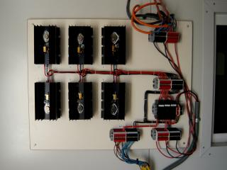
replaced. At this site we have used an experimental solar regulator. Instead of the usual series regulator used normally, we have constructed a parallel regulator. The main advantages of this are that we can derive more charging current for the supply batteries and also, if any component should fail, it would not cause the shutdown of the whole power supply. The picture, above right, shows the parallel regulator. |
 |
 |
 |
 |