Links
to donate
About Disasters
About Diseases
Contact us/ Feedback |
|
I've information on following disasters
Tsunamis
Tsunamis are ocean waves produced by earthquakes or
underwatelandslides.
The word is Japanese and means 'harbor wave,' because of the devastating
effects these waves have had on low-lying Japanese coastal communities.
Tsunamis are often incorrectly referred to as tidal waves, but a tsunami
is actually a series of waves that can travel at speeds averaging 450 (and
up to 600) miles per hour in the open ocean. In the open ocean, tsunamis
would not be felt by ships because the wavelength would be hundreds of
miles long, with an amplitude of only a few feet. This would also make
them unnoticeable from the air. As the waves approach the coast, their
speed decreases and their amplitude increases. Unusual wave heights have
been known to be over 100 feet high. However, waves that are 10 to 20 feet
high can be very destructive and cause many deaths or injuries.
Tsunamis are most often generated by earthquake-induced movement of the
ocean floor. Landslides, volcanic eruptions, and even meteorites can also
generate a tsunami. If a major earthquake is felt, a tsunami could reach
the beach in a few minutes, even before a warning is issued. Areas at
greatest risk are less than 25 feet above sea level and within one mile of
the shoreline. Most deaths caused by a tsunami are because of drowning.
Associated risks include flooding, contamination of drinking water, fires
from ruptured tanks or gas lines, and the loss of vital community
infrastructure (police, fire, and medical facilities).
From an initial tsunami generating source area, waves travel outward in
all directions much like the ripples caused by throwing a rock into a
pond. As these waves approach coastal areas, the time between successive
wave crests varies from 5 to 90 minutes. The first wave is usually not the
largest in the series of waves, nor is it the most significant.
Furthermore, one coastal community may experience no damaging waves while
another, not that far away, may experience destructive deadly waves.
Depending on a number of factors, some low-lying areas could experience
severe inland inundation of water and debris of more than 1,000 feet.
Tsunami are a threat to people and property in coastal and low-lying
estuarine areas. The waves travel quickly, rapidly flooding and damaging
coastal communities, picking up debris as they go. A fast moving wave over
10 metres high can quickly destroy homes and communities. Tsunami also
create seiching in harbours and confined estuaries.
Tsunami waves can travel inland along river beds as continuous single
standing waves. This puts smaller inland communities at risk and
contaminates rivers with saltwater.
A tsunami can threaten 'lifeline' services such as water, power,
telecommunication and transportation networks. Find out more about
managing Lifelines to deal with unexpected emergencies or natural hazards.
How To Prepare for a Tsunami if You Live in a Tsunami Risk Area
Learn whether tsunamis have occurred in your area or could occur in your
area by contacting your local emergency management office, state
geological survey, National Weather Service (NWS) office, or American Red
Cross chapter. Find out your area’s flooding elevation.
If you are in an area at risk from tsunamis, you should:
Find out if your home, school, workplace, or other frequently visited
locations are in tsunami hazard areas.
Know the height of your street above sea level and the distance of your
street from the coast or other high-risk waters. Evacuation orders may be
based on these numbers. Also find out the height above sea level and the
distance from the coast of outbuildings that house animals, as well as
pastures or corrals.
Plan evacuation routes from your home, school, workplace, or any other
place you could be where tsunamis present a risk.
If possible, pick areas 100 feet (30 meters) above sea level or go as far
as two miles (3 kilometers) inland, away from the coastline. If you cannot
get this high or far, go as high or far as you can. Every foot inland or
upward may make a difference. You should be able to reach your safe
location on foot within 15 minutes. After a disaster, roads may become
impassable or blocked. Be prepared to evacuate by foot if necessary.
Footpaths normally lead uphill and inland, while many roads parallel
coastlines. Follow posted tsunami evacuation routes; these will lead to
safety. Local emergency management officials can advise you on the best
route to safety and likely shelter locations.
If your children’s school is in an identified inundation zone, find out
what the school evacuation plan is. Find out if the plan requires you to
pick your children up from school or from another location. Telephone
lines during a tsunami watch or warning may be overloaded and routes to
and from schools may be jammed.
Practice your evacuation routes. Familiarity may save your life. Be able
to follow your escape route at night and during inclement weather.
Practicing your plan makes the appropriate response more of a reaction,
requiring less thinking during an actual emergency situation.
Use a NOAA Weather Radio or stay tuned to a local radio or television
station to keep informed of local watches and warnings.
Talk to your insurance agent. Homeowners' policies do not cover flooding
from a tsunami. Ask about the National Flood Insurance Program (NFIP).
NFIP covers tsunami damage, but your community must participate in the
program.
Discuss tsunamis with your family. Everyone should know what to do in a
tsunami situation. Discussing tsunamis ahead of time will help reduce fear
and save precious time in an emergency. Review flood safety and
preparedness measures with your family.
If you are visiting an area at risk from tsunamis, check with the hotel,
motel, or campground operators for tsunami evacuation information and find
out what the warning system is for tsunamis. It is important to know
designated escape routes before a warning is issued.
Earthquakes
What is the Definition of an Earthquake?
An earthquake is the sudden, sometimes violent movement of the earth's
surface from the release of energy in the earth's crust.
The word earthquake is also widely used to indicate the source region itself.
Earthquakes occur where the stress resulting from the differential motion of these plates exceeds the strength of the crust.
The highest stress (and possible weakest zones) are most often found at the boundaries of the tectonic plates and hence these locations are where the majority of earthquakes occur. Events located at plate boundaries are called interplate earthquakes; the less frequent events that occur in the interior of the lithospheric plates are called intraplate earthquakes. Earthquakes also occur in volcanic regions and as the result of a number of anthropogenic sources, such as reservoir induced seismicity, mining and the removal or injection of fluids into the crust. Seismic waves including some strong enough to be felt by humans can also be caused by explosions (chemical or nuclear), landslides, and collapse of old mine shafts, though these sources are not strictly earthquakes.
What Causes Most Earthquakes?
The crust of the earth when it is subject to tectonic forces, bends
slightly. But, because the crust is rigid, when the stress or pressure
exceeds the strength of the rocks, the crust breaks and snaps into a new
position. Vibrations called seismic waves are generated and travel both
through the earth and along its surface. These seismic waves cause the
movement we call earthquakes.
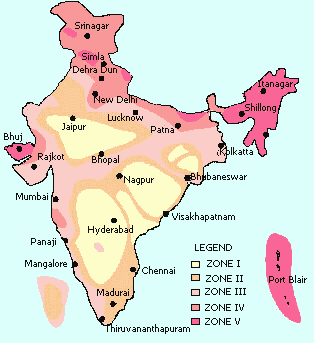
Earthquake Prone Zones in India
Damages caused by earthquake
The effects of an earthquake are strongest in a broad zone surrounding the
epicenter. Surface ground cracking associated with faults that reach the
surface often occurs, with horizontal and vertical displacements of
several yards common. Such movement does not have to occur during a major
earthquake; slight periodic movements called fault creep can be
accompanied by microearthquakes too small to be felt. The extent of
earthquake vibration and subsequent damage to a region is partly dependent
on characteristics of the ground. For example, earthquake vibrations last
longer and are of greater wave amplitudes in unconsolidated surface
material, such as poorly compacted fill or river deposits; bedrock areas
receive fewer effects. The worst damage occurs in densely populated urban
areas where structures are not built to withstand intense shaking. There,
L waves can produce destructive vibrations in buildings and break water
and gas lines, starting uncontrollable fires.
Damage and loss of life sustained during an earthquake result from falling
structures and flying glass and objects. Flexible structures built on
bedrock are generally more resistant to earthquake damage than rigid
structures built on loose soil. In certain areas, an earthquake can
trigger mudslides, which slip down mountain slopes and can bury
habitations below. A submarine earthquake can cause a tsunami, a series of
damaging waves that ripple outward from the earthquake epicenter and
inundate coastal cities.
Safety rules to be followed during an earthquake
Prepare a Home Earthquake Plan
Choose a safe place in every room--under a sturdy table or desk or against
an inside wall where nothing can fall on you.
Practice DROP, COVER, AND HOLD ON at least twice a year. Drop under a
sturdy desk or table, hold on, and protect your eyes by pressing your face
against your arm. If there's no table or desk nearby, sit on the floor
against an interior wall away from windows, bookcases, or tall furniture
that could fall on you. Teach children to DROP, COVER, AND HOLD ON!
Choose an out-of-town family contact.
Consult a professional to find out additional ways you can protect your
home, such as bolting the house to its foundation and other structural
mitigation techniques.
Take a first aid class from your local Red Cross chapter. Keep your
training current.
Get training in how to use a fire extinguisher from your local fire
department.
Inform babysitters and caregivers of your plan.
Eliminate Hazards, Including--
Bolting bookcases, china cabinets, and other tall furniture to wall studs.
Installing strong latches on cupboards.
Strapping the water heater to wall studs.
Prepare a Disaster Supplies Kit For Home and Car, Including--
First aid kit and essential medications.
Canned food and can opener.
At least three gallons of water per person.
Protective clothing, rainwear, and bedding or sleeping bags.
Battery-powered radio, flashlight, and extra batteries.
Special items for infant, elderly, or disabled family members.
Written instructions for how to turn off gas, electricity, and water if
authorities advise you to do so. (Remember, you'll need a professional to
turn natural gas service back on.)
Keeping essentials, such as a flashlight and sturdy shoes, by your
bedside.
Know What to Do When the Shaking Begins
DROP, COVER, AND HOLD ON! Move only a few steps to a nearby safe place.
Stay indoors until the shaking stops and you're sure it's safe to exit.
Stay away from windows. In a high-rise building, expect the fire alarms
and sprinklers to go off during a quake.
If you are in bed, hold on and stay there, protecting your head with a
pillow.
If you are outdoors, find a clear spot away from buildings, trees, and
power lines. Drop to the ground.
If you are in a car, slow down and drive to a clear place (as described
above). Stay in the car until the shaking stops.
Identify What to Do After the Shaking Stops
Check yourself for injuries. Protect yourself from further danger by
putting on long pants, a long-sleeved shirt, sturdy shoes, and work
gloves.
Check others for injuries. Give first aid for serious injuries.
Look for and extinguish small fires. Eliminate fire hazards. Turn off the
gas if you smell gas or think it's leaking. (Remember, only a professional
should turn it back on.)
Listen to the radio for instructions.
Expect aftershocks. Each time you feel one, DROP, COVER, AND HOLD ON!
Inspect your home for damage. Get everyone out if your home is unsafe.
Use the telephone only to report life-threatening emergencies.
Steps to prevent earthquake hazadr from becoming a disaster
Earthquake resistant building
Reinforced Hollow Concrete Block Masonry (RHCBM) elements are designed
both as load bearing walls for gravity loads and also as shear walls for
lateral seismic loads, to safely with stand earthquakes. This structural
system of construction is known as shear wall – diaphragm concept, which
gives three-dimensional structural integrity for the buildings.
[img]
Structural Features:
Each masonry element is vertically reinforced with steel bars and
concrete/grout fill, at regular intervals, through the continuous vertical
cavities of hollow blocks.
Similarly, each masonry element is horizontally reinforced with steel bars
and concrete/grout fill at plinth, sill, lintel and roof levels, as
continuous RC bands, using U-shaped concrete blocks in the masonry course,
at respective levels.
Grid of reinforcement can be built into each masonry element without the
requirement of any extra shuttering and it reduces the scope for corrosion
of reinforcement.
As the reinforcement bars in both vertical and horizontal directions can
be continued into the roof slab, and the lateral walls respectively, the
structural integrity in all the three dimensions is achieved.
[img]
Training
Training should be given to students and teachers on how to react during
an earthquake. These training camps should be organised in between public
places so that they can attract public's attraction.
Case Study
The 31 Dec 1881 Mw=7.9 Car Nicobar earthquake
This earthquake caused minor damage in the Andaman Island Penal colony and
generated a tsunami that was observed throughout the Bay of Bengal but not
along the Burmese coast. The tsunami did no damage around the Bay of
Bengal where tide gauges recorded a maximum amplitude of 0.8 m (Oldham,
1884). An analysis of five tide gauge records reveals that the earthquake
was Mw=7.9±0.2 and occurred on an east-dipping thrust fault below and to
the west of Car Nicobar, an island at 9¡N midway between the Andaman and
Nicobar islands (Ortiz and Bilham, 2003). GPS measurements at Port Blair
indicate oblique convergence of the plate boundary (Paul et al. 2001). The
earthquake is believed to have occurred on the interface between the
Indian and Andaman Plates and the inferred mechanism of westward slip of
the hanging wall slip is consistent with slip partitioning between the
dipping subduction zone, and the strike-slip West Andaman fault east of
Car Nicobar.
A feature of this earthquake is the inferred presence of a region of minor
slip NE of the main rupture zone. This may have been a secondary
earthquake triggered by the mainshock. Its timing would have to have
occurred within a few minutes of the mainshock for it to have produced the
sea wave observed at Port Blair. Local populations were concentrated in
only two islands and therefore there is no corroboration of this inferred
northern region of submarine faulting which occurred between them. It is
probable that offshore corals may be of use in reconstructing an extended
history of earthquakes in the Andaman-Nicobar islands. The island of Car
Nicobar is believed to have been raised and tilted during the 1881 event.
Deformation models that do not include this uplift result in an
inappropriate estimate of the observed tsunami run-up on the island (Ortiz
and Bilham, 2003).
I'll be adding more information soon.
|