Mount Reinier, USA 10.August - 18.August 2001
[In Finnish] [In English]
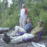
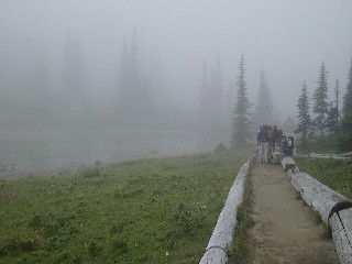
Photo. From left Val, Charles, Rich, Kevin ja Miikka.
Introduction
Summer 2001 was a real beckbacking summer, when I spent half of my vacation on trails. Earlier in the spring, my friends Val and Charles asked me to join their backpacking trip to Washington State in the northwestern States. Well, it was an easy choise, espeacially, when I had also a business trip at same time to the other side of Atlantic. After the desiccion just thinking how to get all my equipments to the other side of the ocean. After some problems with flight tickets, hotels and some other things, I was on August 10 early in the morning in Helsinki airport waiting for the flights to Seattle. What a terrible day in the planes: all together 21 hours, when I left my home at 7:30 am and arrived to my hotel in
Seattle at 7:30 pm, means next morning 4:30 am in Finnish time. Everything worked perfectly: no problems with flight schedules, in spite of my fear I got all my baggages and even no problems in the US customs in Seattle although my XXL-size bags. There is not too much to tell about 21 hours in the planes: booring! Well, one great moment: first time I flought over Greenland so that I could see the ground. A real beautiful view. And of course, just before landing in Seattle, I saw Mount Reinier first time. The huge volcano stands high over everything else!
On Saturday, I was hanging around in Seattle and waiting for the others. They had a flight from Chicago on Saturday and then, in the afternoon also Val, Charles, Kevin and Rich arrived Seattle. With those we sent the afternoon in Seattle and made the last shopping in the REI hiking "mall", which is a real paradise for backpackers who need something to buy. Next morning we had a brunch in the famous Space Needle tower. The view over whole Seattle was great. Pity, that it was foggy and we couldn’t see Mount Reinier. The brunch was expensive but the view and the food was really worth of it. And the prices in States are high anyway for a Finn, due to high exchange rate of USD.
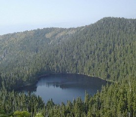
From Seattle we took a ferry to Bremerhaven, and further with a rental car to the coast of Hood Canal, which is actually a bay of the Pacific Ocean. Next two days we stayed in Alderbrook Resorts. In first afternoon we tried to find a store to buy some food, we also made a short walking near the resort and in the evening we played horseshoe for a couple of hours. And we even swam in the Hood Canal: water was cold and very salty! Next morning we wanted to see the Pacific Ocean. I had seen it already in Japan, but now we were in the other side of the ocean. The morning was chilly and foggy, and when we came after two hours driving to the coast, in spite of the sandy beatch thre was not too much to see. We didn’t spend too much time in the beach, but decided to drive back to Alderbrook. Another option was to drive round the whole Olympic national park, but the weather was not nice and the way to drive too long. When we got back to Alderbrook we decided to make an afternoon hiking. From the resort they told us to go to the ranger station about half an hour away. From there we were guided to the southestern corner of the Olympic national park. There we found some nice a couple of kilometers long trails. The area was real nice: forest, big trees, hills, a lake and interesting river. Something what was supposed to be seen in next days. In the evening I fell asleep fast, although was excited, because in the next day the real backpacking will be started.
1st Day Tuesday 8/14/01 Alderbrook-Tacoma-Mowich Lake-Spray Park-Mowich Lake
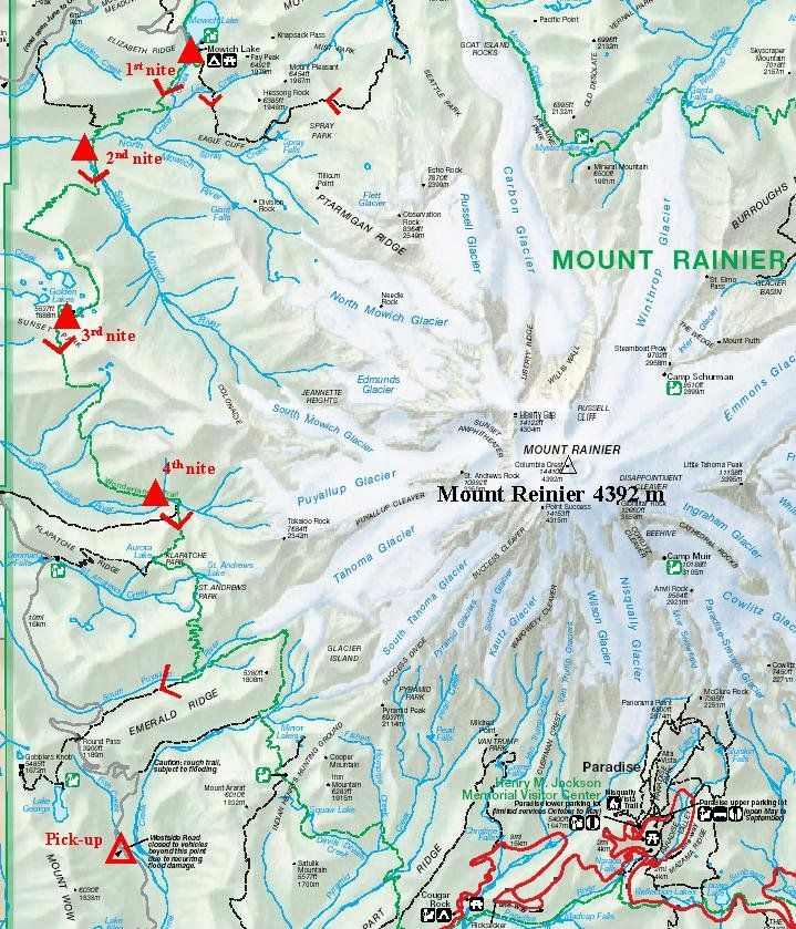
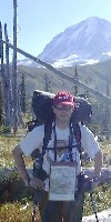
We woke up really eraly in the morning. We had to be in Tacoma at 8 am. In Tacome we were going to return our rental car, and there also the shuttle service would pick us up and take us to the Mount Reinier national park. Just before 8 am we found the hotel to return the rental car. The shuttle also found us and picked us with huge amount of baggages. It took nearly two hours driving to get to the national park. Our friedly chauffeuse told us about the park, where to visit and a lot of useful information. We stopped at a ranger station to pick up our permits for backpacking. For me as a Finn, these permits sound strange. In Scandinavia, we have so called "all men’s rights", value of those we even don’t fully understand. The permit is needed both for backpacking and for tent sites. We were in the park in the best hiking season, so Val had problems to get permits. We couldn’t get the permits to our original route, but after a lot of work, Val managed to get a nice permit and tent sites. After getting the permit, our way continued on a very small and curvy way up to the Mowich Lake, which would be also our first night site. Finally we reached the parking lot and took our bags with us, except Val’s poles that left in the shuttle, small mistake. Then some tens of meters to the old parking lot, that was a present tent site. We stand our tents up into the corner of the lot. Then we ate lunch, in American style, subs. We also saw our home marmot, which had his home just 5 meters from our tents.
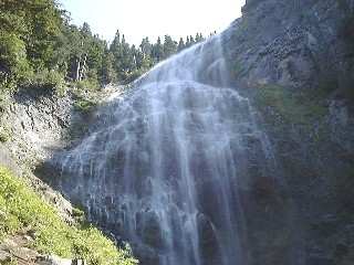
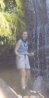
Because we stayed next night in Mowich Lake, we had to have something to do in the afternoon. We heard that Spray Park 5 kilometers away would be worth of visiting. So, some water with us and to the trails. My first steps in the American trails were easy. The trail was in perfect condition, wide and easy to walk, especially, downhill. We walked on a side of a ridge under high pine trees. Outside the trail the ridge was quite steep, but the trail was quite easy. We walked down, and soon we started to hear the sound of water fall and also temperature dropped. From the main trail there was a smaller trail to Spray Falls. We walked there and it was really worth of that. We climbed up on side of the river as long as we were just under the fall. Water came down as 50 meter wide fall and dropped 20 meters stright down. Water was ice cold, but the view was excellent.
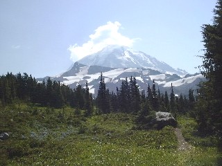
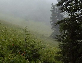
From the falls we continued uphill towards the Spray Park. With the dictionary I understood, that meadow means same as the German word "Alm", but in practise in Mount Reinier area meadow means more like a moor. Spray Park was gorgeous! All flowers were blooming, and you could smell them everywhere. The sun was shining and temperature was about 30 Centigrades. The of course, the great Mount Rainier with it’s glaciers on the top. We walked further in the Park. There were quite many hikers on the trail. Some dayhikers, like us, but also backpackers with their huge bags. Here we saw also a lot of seniors who were going to stay longer time in the park at least they had huge bags with them. We found also some snow, which meant of course snowball war. Due to high temperature we had to drink quite a lot, so some of our group took risk and filled their bottles with snow. From the snow we turned back to Mowich Lake. Although we had the same trail back to the camp, there were still nice views to see.
In Mowich Lake it was time to swim. Water in the lake was cold, but so refreshing. As a dinner we cooked beef Stroganoff, or actually added boiling water to freeze dryed food bag. Nothing gourmet, but it worked, although the portion was quite small. Val made also cheese cake mix as a dessert. Later in the evening we though some football, found a small water fall just near the camp, made a small night walk on the lake coast. Then came time to go to bed, first time in the tent in this trip.
2nd Day Wednesday 8/15/01 Mowich Lake - South Mowich River
We woke up at 7 am, but we were almost last ones in the camp site. I waited excited for the breakfast, I have some besd experiences about the American breakfast. But the breakfast was familiar for me, the same oatmeal, that we always eat in our European backpacking. Then all staff to the bags and last tunings. And to the road! First day was quite easy, at least on the map: about 6 km and all way downhill, downwards about 800 meters.
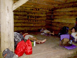
We walked in the same kind of forest as yesterday, of course we were mostly on the same ridge. The trail was really easy to walk, but outside the trail the hill was steep. So, it means switchbacks. A lot of switchbacks. In Norway we usually walk first day uphills, so we can say that's why it's a hardest day, but now the downhill was absolutely tough enough. It was hot already in the morning, so drinking was important. I had Finnish yogurtpineapples as a snack, and also my friends liked those. Finally we reached the lush river valley. We walked on a bridge over North Mowich River and it was just some hundred meters from river to the camp site. We took a shelter for Rich's sleeping place and others backpacks' shelter. The lunch sounded quite exotic for me: warm pita breads filled with salami and cheese. Heavy to carry, but really tasty. The first day made us tired and Kovach brothers decided to take nap. Other three just made something. I filter water first time in my life, while we have had clean water in Finland and in Norway in my earlier backpackings. Another new thing for me was a bear pole to hang all food to avoid unneeded guests.
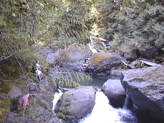
We had heard that there was no bridge over South Mowich River next morning. The river crossing was not far a way from our site, so we walked there to find out the crossing. The river was fast and gray of sand, coming from glacier. We choose poles to train the crossing. The water was running on the knee level and even higher and the fast water caused problems. We found some easier places to cross and finally we even played a little bit in the ice cold river. Then it was time for dinner. The menu was some kind of chicken, but I have to say that I missed Harri's food (a friend of mine has a possibility to freeze dry our foods by himself). Some other hikers came also to South Mowich camp site and soon all the sites were full. We talked quite a bit with an older guy about backpacking areas and everything possible. There were quite many people walking alone in the Reinier area. A couple of other hikers were more like a Finnish type, they hardly said hello. For me this was quite strange, when I'm used to Austrian and Norwegian way to talk with everybody in mountains. In the evening we still made small walking and then it's was time to collect some power for next day, first in the morning the river crossing and then 800 meters steep uphill to the next camp site.
3rd Day Thursday 8/16/01 South Mowich River - Golden Lakes
Up again at 7 am. Well, the breakfast was more American style today: hash browns. Well, that was some kind of energy anyway. Everything to backs and on the road again. We were last ones again. An older guy forgot his knife, hopefully he had a spare one with him.
First job was the river crossing. We had heard that the water level would be lower in the mornings, but we were really suprised when we came to the river. The wild river of yesterday was just a small stream, which could be crossed with taking shoes off. Of course this was not any bad thing, we just changed our sandals for river crossing back to the boots and continued the trail. Then the switchbacks started. Left and right, left and right and up and up... A couple caming down told that they had passed 14 switchbacks and we had counted 22 up. After all we counted 37 switchbacks and 800 meters up, quite hard job! After the switchbacks we came to an open meadow, where the burning sun took the rest of the power. Fortunatelly, our camp sites were not too far away. The sites were great. There were a lot of small lakes in the area and the sites are between those lakes under tall threes. We went down to a lake to filter some water, and then we had a gorgeous view to Mount Reinier! Then it was time for lunch: chicken soup, just like in Finland, hardly any chicken... If the lunch was not a top point of the day, the next one was. After a sweaty day, swimming in a small like was great, although water was quite cold. There was a small island in the lake, and that was a nice place to swim and wash ourselves. The only bad thing in the perfect moment were horseflies which tried to eat us always when we were up from water.
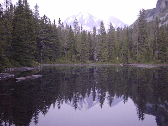
Golden Lakes were very popular camp site, even so popular that there were not enough sites for everybody but we helped each other and some "extra" sites were found. Also in our site had a extra alone hiker, who had just a small back with him. Not even a tent he had, but just a sleeping bag and a tarp. Golden Lakes was also a international site, from Europe there were me and two German girls and also many Canadians. We spent time on the lake to wonder Mount Reinier. We asked also other people came down there to see the great view and everybody were surprised about the great view, because any guide book tell about the view from the other side of the lake behind the patrol cabin. Another great view down to the river valley was between camp sites 4 and 5. Time ran fast watching views, drinking Everclean and talking to other people. Some of us were teased by mosquitos, but I as a Finn didn't even notice those. Just before the sunset we walked down to the lake once again. The view was absolutely the most gorgeous on the trip: Mount Rainier in the setting sun and the reflection of the mountain on the lake.
4th Day Friday 8/17/01 Golden Lakes - North Puyallup River
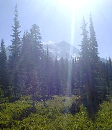
Yesterday was tough enough, so that I slept first time until my watch alarmed. And I was even the first one after the guy slept in our site. Also the others woke up, and we started to make breakfast and pack again. This day would be easy, short trail and downhill. Well, in the beginning there was some uphill from the lakes, but then the trail turned to downhill. First watching some last lakes, and then forest and to the old forest fire area. From the open area we had the best view to Mount Reinier in our trip. And also the view down to valley was not too bad! Time to take some photos, especially when the hot sun was shining from the clear sky.
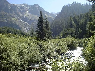
The trail ran further, and we came to our tent site just before the noon. We would have liked to go even further, but we couldn’t get the permit. We decided to obey our permit, and stay in North Puyallup site, although we could have walked further. A good decission, because later in the evening a ranger lady came to our site and checked our permit. We put up our tents, ate lunch and went down to the bridge of North Puyallup to have great views to glaciers and the rapids which could have seen far in the mountain. We also made a small walk on the old road with a lot of big plants nowadays. We saw also bear scratchs and rasberry bushes all berries eaten at bear level. Rest of day was just laying and throwing foorball. We also watched map to make a decission for the trail of the last day. Seeing the bear scratchs helped our route decission. Our site was silent when only the group site and one normal site were grounded. We spent also the evening near the bridge. We tasted Finnish crackers and Americans seemed to like it, maybe they were just polite. Later in the evening the clouds started to fall down, and it looked like to start raining, but it didn’t start anyway. The weather look so bad, that Rich who normally slept under open sky made a plastic shelter to cover him. The last day was the longest day, over 10 miles, so we went early to bed, and also turned our watches to alarm earlier than normally.
5th Day Saturday 8/18/01 North Puyallup - Klapatche Ridge - South Puyallup - Westside Road
Probably I was a little bit excited about the last day, because I woke up every now and then during the night. I was not alone, because also the other ones started to wake up at six o’clock, although we had discussed about half past. The morning was also different. We were inside a cloud, and temperature had dropped to 10C. The packing took shorter time than earlier and also we had fast breakfast: Finnish plum apple oat meal. Rich and Kevin told that they are not as fast as we young, and they left a little bit earlier. Well, the difference was just fifteen minutes.
We walked on the familiar bridge over North Puyallup and then started switchbacks. There was 700 meters uphill. This time the trail was very steep, and we had to work quite a bit. I liked this more than two days ago, when the altitude was bout the same, but switchbacks were not so steep, but they were longer. The switchbacks were in two sections. First long and steep section, then easier one and in the end again short switchbacks. We walked quite fast and just before the second switchback section we reached Rich and Kevin. The view might have been gorgeous, but we could see just some tens of meters in clouds and fog. Temperature was so low, that first time we had to put more clothes on when we stopped to have a break. In the top of the bridge there were nice meadow views again, or would have been if we hadn’t have so mych fog. We reached Klapatche Park on the top of the ridge within two hours, so we were ahead of our schedule. We needed the schedule, because we would have been picked up from West Side Road at 4 pm.
From Klapatche Ridge we started to go down through Klapatche Park and St. Adrews Park meadows to South Puyallup River. In Klapatche Park Rich and Kevin were walking twenty meters ahead of us, they suddenly stopped and said the magic word "bear". Really, there was a bear we have waited and been a little bit scared. Some other hikers were talking, that they have seen bears and last day we saw scratches near our camp site. The bear was about hundred meters from us and 50 meters below us. It was probably one of the yearlings they have warned in North Puyallup and Klapatche sites. It was observing us and we were observing it. After a short break to see bear and take some photos we were continuing our ways to different directions. We tried to be noisier than normally to ensure that we wouldn’t meet any other bears. From St. Andrews Park it was quite steep downhill. The trail was brushy and some of small bridges were in bad condition. At last we started to hear South Puyallup River and we came to the camp sites. Time for a lunch break. The sites were in a storm area, and there were a lot of fallen trees. The sites were in a good condition anyway. We had a cold lunch, means sandwitch and what ever you had leftovers.
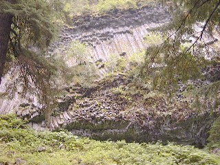
After the lunch we get off from the Wonderland Trail, and turned towards Westside Road. Just after the camp site, there was an exciting view. A steep was formed of volcanic stones like square pillars. The trail get into the forest and the road came closer and closer. Just before the Westside Road we decided to make a shortcut through Round Pass Trail. This was not such a good idea, because suprisingly it was mostly uphill, last one on this trip. After the shortcut we reached Westside Road, of which we still had about 5 kilometers to walk. Before this road "march" we visit the monument of the airplane crushed in 1946 near the top of Mt. Reinier. The weather was so clear that we could even see the glacier where the plane was crushed. Then on the road. The hard road was not so nice to walk with tired legs. We also noticed why they couldn’t drive on the road: flood had taken part of the road. Just before we get our pickup point we saw Mount Wow. We easily understood the name: the mountain was dropping almost one kilometer steep down. We were quite tired when we get the end point. But we were half an hour before the schedule. The shuttle was already waiting for us, they told that they just arrived.
The shuttle took us first to Ashford village, there we could buy what we have waited for: icecream, coke, beer. Then we drove further to our motel in Tukwila near Seattle Airport. We ate our final dinner in Rainforest Café, and the desert was called for some reason "Volcano".
Summa Summarum
For me who had made backpacking in Finland, Norway and Austria, backpacking on the side of the Atlantic was partly similar but partly different. I decided not to have any attitude before the trip. Of course, I know standard Americans who can hardly walk 10 meter from their cars. On the other hand I had the map of the area, which showed also some difficult parts on the trail.
Technically there were no differences between backpackin in Europe and in the States. The altitude differences and steepness were about the same as in Norway just a couple of weeks before. The trails were in perfect condition that made walking easier in Mount Reinier. My equipment were exactly same as in Norway or in Finland. The warm and nice weather made everything easier. The Finnish trail food is quite similar as in the States. Of course we could see the fastfood culture also on the trail, but I got also some new ideas. Hanging the food and filtering water sound worse than they actually are.
The views were partly the same as in Europe, but there were also some differences. I don’t believe that we have in Europe anything like great Mount Reinier volcano. Besides, forests were just like in southern Finland, if you didn’t notice the altitude differences. Mount Reinier area is quite varying, when we could see in the small area everything from glaciers and rivers to meadows and groves.
Absolutely a great tour! I won’t get a possibility to make this kind of trips many times in my life. Maybe there will be a day to fly back to Mount Reinier. Or then to Olympics that seemed even more interesting.
Kuulostiko kiinnostavalta? Lisää tietoakin annetaan haluttaessa!
If you want to know more, just email me!
Leider ist unseres Mount Reinier Story nur im Finnish, aber wenn Sie mehr wissen wollen, schicken Sie mir E-mail, bitte!
[email protected] tai/or/oder [email protected]