Glacier National Park, Montana, USA
July 30 - August 11 2002
[In Finnish] [In English]
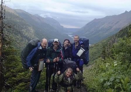
Photo.
Front Tina, back from left Miikka, Kevin, Valerie and Charles.Prologue
My alarm watch is waking me up at 4:50 am. For a short period I’m wondering why, I’m on my vacation. Oh yes, I’m going to fly to Montana to US near Canadian border and then all together 12 days backpacking on Rocky Mountains. Clothes on and to the airport. It takes a while before Finnair officer finds a place called Kalispell in her computer. But it doesn’t help too much. In my ticket bunch she can only get a flight ticket from Helsinki to Amsterdam, my luggage she can check even to New York. Just a short flight to Amsterdam and then to a transit desk to the end of long line. The transfer time is getting shorter and shorter and the officers are already asking if there are still some New York passengers on the line. After a tight verbal security check-in I’m almost a last one in the plane. Then booring 8 hours on the plane, but soon we are landing at JFK in New York. The passport control is surprisingly easy at non-citizen desks. In stead of this, the US citizens are standing on the cattle line, like I’m used to. After the customs, there is a little mess, when I have flight tickets to Salt Lake City, but my luggage are just checked to New York. Well, at last they understood the problem and I got new tacks to my luggage. And then waiting for the next step to Salt Lake City. At JFK I drank the most expensive beer I’ve drunk outside Japan, $6! After waiting a five hour flight to SLC. When I arrived there, I was really happy, that I decided to stay at SLC over a night and continue to my final destination next day. After 24 hours travelling sleeping at the airport hotel was feeling great. In the morning breakfast at the hotel and back to the airport and less than two hours flight to my final destination Kalispell in Montana. After landing at Kalispell I walked to wait my luggeges coming, and then somebody was knocking my shoulder. "Hi Miikka", Charles and the rest of our group was there already waiting for me.
I was already concerned when my luggage was not on the belt. A bigger concern was that Charles and Kevin told Val had hurt her angle and was not sure if she could hike with the angle. At last the luggage came on the belt and everything I needed was with me. Then we walked to their cars, and Tina and Val were already waiting for us. Everybody into cars and then we had one hour drive to Glacier National Park. First we drove to West Glacier and into the park and towards Polebridge. In Polebridge we had reserved a cabin for two next nights. When driving to Polebridge we passed a large forest fire are. It was almost scary to drive miles and miles in a forest with only burned trees. Later we heard that the area had burned year 2001, so any new vegetation hadn’t grown yet. We arrived at Polebrigde, which means a grocery store, a saloon, a camping area and a few other houses. We also found North Fork Hostel, where we were going to go. Cindy friendly guided us Square Peg Ranch, where our cabin was. The guidance was very friendly: "Go and look. If you need anything else just come back here". And we didn’t need anything else, a large cabin, certainly enough room for five, a nice fireplace and a fridge. There was not drinking water and the toilet was outdoors, but this was not any hotel anyway.
We went back to the hostel and just hang around for a while talking with different people. Then we visited Polebridge Mercantile store, that was a really nice grocery store with a bakery. We found everything we needed. It’s was already late afternoon and we were hungry. We decided to visit Norther Light Saloon. Our first visit was quite peaceful, or at least compered to our next visit after our backpacking. Together with excellent food we found interesting notes of Polebridge history in paper tablemats. After dinner we drove back to our cabin and made some firewood for the night and next morning.
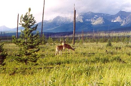
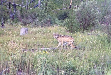
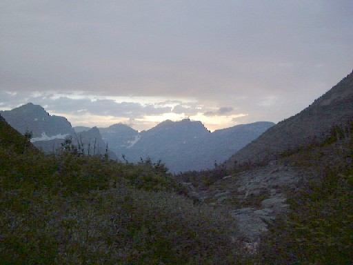
It was not too late to do something else. We decided to drive some 15 miles to Lake Kintla to view sceneries. The road was rough and we were funny to see the speed limits, according of which we should have driven faster in curves and our car was even a truck. We drove through nice meadows seeing nice mountains back there. At last we reached Kintla campgound. We watched the mountain view, took some photos and made a small walk. It was getting darker, so we decided to start driving back. The views were gorgeous, and backpacking fever started to raise when watching to mountains and thinking that two nights we’ll be. The drive got slower when we saw some dears on the side of the road. We stopped to take photos and they didn’t care us at all. We drove further and then something jumped over the road just ahead of us. Charles stopped the car and we noticed what the animal was. A wolf! It stopped about 20 feet from us and watched us and we watched even more it. A nice animal, when I saw a wolf first time in nature. After a while we drove back to our cabin, lighted a fire and just had fun. Going to the toilet was little bit exciting because we were told that Dakota bear with her cubs lived just behind the cabin. Soon we got tired and went to our nice, soft beds.
Thursday 8/1/02 Going-to-the-Sun Road
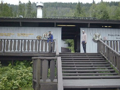
The wake up in the morning was cool, and the reason clear when the car windows were frozen. Fire to the fireplace and soon the cabin was warmer. We ate breakfast and went to the hostel to take shower. The hostel had almost only public shower in the neighbourhood with warm water. Well, they had also public internet but we were not so hooked. The next step was Polebridge Ranger Station to get our backpacking permit for next morning. We got our permit easily. We had to watch a safety video. It was somehow useful but also funny. It was shown how to act if a bear or a mountain lion attacks. They showed also some common backpacking safety, that I was already very familiar with after hiking back home. We went back to the cabin with our permit ready for the adventure of the day. Practically, I don’t support car travelling, so I was not too sure about our plan to drive through the Going-to-the-Sun view road.
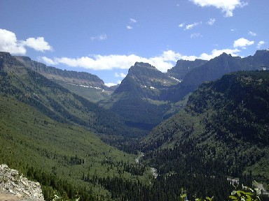
First, we drove to Apgar. The village was a real tourist place. We visited the Park visitor center, bough T-shirts and other souveniers from the tourist shops in the village. Charles called to work, and Val and I were really disappointed. Well, I talked also something with Vili. After lunch we were ready to go on. First GTTS road drive on the side of Lake McDonald and then it followed McDonald Creek. And the view got better and better. And we drove higher and higher. And the view got better and better. Every now and then we stopped our car and took photos. The road was quite crowded and there were really many touristists. I can understand the reason. The views were gorgeous! Also the building of the road is a great engineering work, because the road was really steep (you can see road down by the creek). The highest point of the road is Logan Pass at 7500 feet, when our starting point Lake McDonald is at 3000 feet. At Logan Pass there is a visitor center, but on our first trial the parking place was full and we decided to drive on to downhill. After the visitor center we saw some big horns just close to the road. After driving for a while we turned back and decided to try to get a parking place at the visitor center. This timer we were lucky and got a parking place.
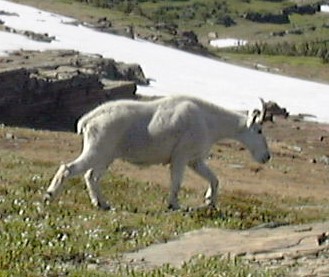
We checked the visitor center, and noticed that they had a one-mile trail to Hidden Lake. We needed a small walk after sitting in the car. Partly the trail was like a highway, partly steps and partly a real trail. The trail went over snow patches that were perfect for snow war in hot weather. We were so close to the tree level that the view was partly low trees and partly open alpine meadow. Together with people on the trail walked mountain goats, and they didn’t pay any attention to the crow. In the final end of the trail there was a gorgeous view point down to the turquoise colored lake. After a nice walk we started to drive back. The view was still great and narrow, steep road was still scary towards downhill. We drove West Glacier to make last shopping before our backpacking tomorrow. It was getting dark when we got back to Polebridge. We packed our backpacks to be ready early tomorrow morning. Valerie’s angle was better, so anybody else was not afraid if she could come with us. She by herself hadn’t been afraid at any moment. At least I was feeling excited when going to bed. At least, today’s drive was gorgeous.
1st Day Friday 8/2/02 Bowman Lake Foot - Bowman Lake Head (11.4 km, no elevation gain up or down. Remark. According to Glacier National Park)
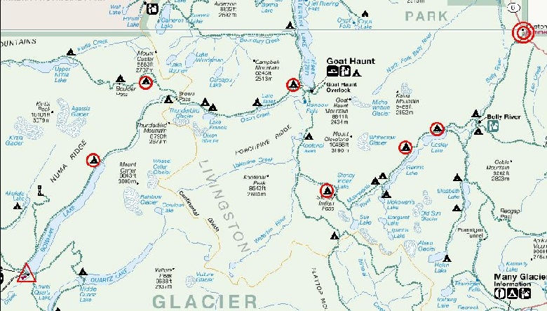
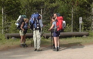
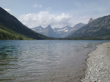
It was still dark when we woke up and ate a fast breakfast. We packed all our bags to our cars and cleaned the cabin for the next visitors. Well, we'll be back after the 7-days backpacking. We drove Kevin's car to the hostel and left it there over the backpacking. Then we all fitted into Charles' truck and we drove to the direction of Bowman Lake. It would be the starting point for the hiking. The road was gently said rough, and with a normal car it would have been impossible to drive. After 6 miles and half an hour we came to Bowman Lake, and it was time to put backpacks on and start walking. Our first day was at least in principal easy, 10 km on the coast of the lake from head to foot.
Easy. In principal. No elevation gain up or down. The first day is always the first day, and the bags are full and heavy, and not packed very well. So, there was enough hiking on the spruce forest. Every now and then we could see the ridge on the other side of the lake. It was nice and something that we gonna see during the next days. But the way was long enough. The lake seemed to continue and continue. We tried to check the map, that we are almost there in our camp site, but then we noticed that we are just there, not any further. We didn't see a lot of other people. One couple, but nobody else. We started really early but still we were suprised not to see other hikers.
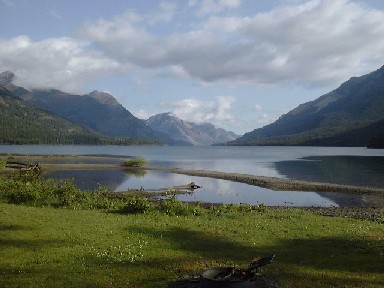
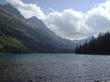
Finally, we reached the lake head. We were the first ones on the camp site, so we hit our small target to choose the best sites. We found two excellent sites separated from other sites by a small creek. We put up our tents and then ate a late lunch. After lunch we checked our gear, hang food to the cable, filtered water etc. Kevin took his fishing pole and tried his fishing luck. The wind got harder and dropped the temperature. When watching the lake, we noticed a small black point there coming closer. First we thought it was a canoe, but then we noticed it to be a small motor boat. The boat came closer and closer, even to the camp site. Unfair to use a boat for the same trip we've walked earlier this morning! In the boat there was a nice couple we talked that evening and even next day a lot. Later in the afternoon, a group of three young men came to the site, but nobody else, even though all the sites should have been booked. So, only four of six sites was crowded. Before the dinner we made a small walk. The north head of Bowman Lake and Bowman Creek were eagle nesting area, and it was allowed to walk only on the trails. After the dinner we made a fire and talked with the couple until the dark.
2nd Day Saturday 8/3/02 Bowman Lake Head - Hole-in-the-Wall (13.8 km, elevation up 800 m down 80 m)
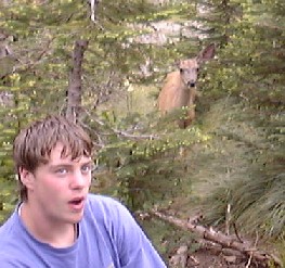
We were supposed to wake up at 6 am in the morning, but either of our tents (Val, Charles and I) didn't hear our alarm watches. After half past six we anyway got out from our tents and noticed, that Tina and Kevin were already having breakfast. After the morning things we were ready to go. The breakfast area was quite busy, when a deer also wanted to have some.
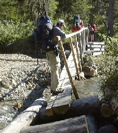
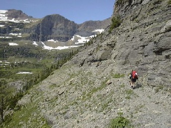
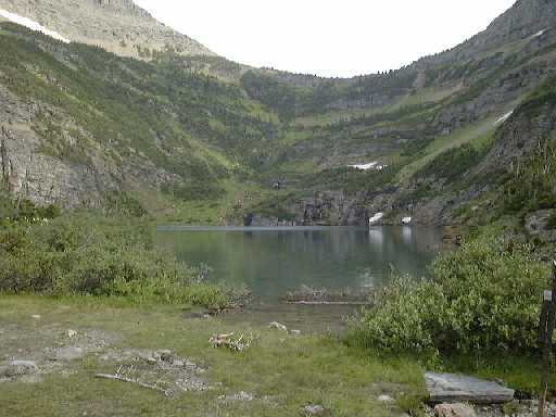
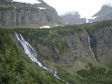
In the beginning the trail was following Bowman Creek and ran through the spurce forest and also we passed damp areas. For some reason I was feeling very weak in the beginning, but after we had a pause and ate somethin sweet I got better. We had a pause just by the bridge going over Bowman Creek. Going over needed some acrobatics, especially with a backpack. After passing the creek, the trail started to go uphills. Simultaneously a great view opened to the valleys. We could even see the final destination today. Hole-in-the-Wall was a valley on a high ridge and spectacular water falls came down from the plate. There was enough uphill certainly. Sometimes there was switchbacks and sometimes just steep uphill. The trail itself was in perfect condition, but it was quite bushy and sometimes we had to use our hiking poles like mecetes, when leaves were as high as our feet. We reached an old avelance area, because there were no trees in a steep area. We decided to have a lunch break. It was feeling great when we could take our bags off. It was pretty windy and needed more cloths from the bag. After the lunch we continued to even steeper uphill. We also noticed the couple seen last evening few hundred feet lower than us. Thay have decided to make a dayhike to Hole-in-the-Wall, but they were going to go back to Bowman Lake for the night. Although they were just under us, it took a while before they reached us. Finally, the steepest uphill ended and we passed Brown Pass campsite. There were also some snowpatches on the alpine meadow and we even missed the trail for a while, but easily we found the trail again. Someone were also conscious that we had already passed the junction where we should turn another way. We found the juction without problems, we just had to walk further. There also the couple reached us and we talked some time. There were still two miles to our campsite. Kevin and Charles speeded up, the girls and I took it a little bit easier. The trail was getting like a real alpine trail in Austria, when we were were walking around a cliff, 1000 feet wall under us and vertical wall above us. The trail was just three feet wide. At the same time we could see our campsite valley. It was like a cup, there the waterfalls first dropped to the cup and then down to the valley we had came up. We didn't wondered anymore why they said this place one of the most beautiful campsites in the US. The trail went down to the valley and our long seven hour hike was over.
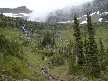
Tents up and watching the place. I have to say that the view from the pittoilet was the best toilet view I have had. After a sweat day we really needed washing, and when it was possible, I did it just under a two-meters high waterfall. Water was freezing, when it came straigh from snow. We also counted water walls round Hole-in-the-Wall and there were 24 water falls around us, absolutely gorgeous view. The only campsite I could even think to be about same level has been in Blåtjörnholen valley in Joptunheimen in Norway in summer 2000, when the sunset made a huge glacier shining in blue color.
It was getting later and clouds were trying to come down to our valley, but ridges kept those away for sometime. When having dinner it was also getting cooler and we put almost all the posiible clothes on against coolness and wind. We were quite suprised, that there were nobody else on the site except us. The couple met in Bowman Lake told that also the Hole-in-the-Wall was fullbooked, because the wanted to stey there, but couldn't get a permit. After the lunch Val, Charles and I decided to make an expedition in the cliff were the waterfalls dropped down. Tina and Kevin were so tired that they went to their tent to have some rest. First we explored some snowpatches and found some snowcaves that were big enough to go in those. Then we tried to find to route to the cliff. There was no trail, so we just followed some low ridges. The down hill got steeper and steeper. In one place we decided not to any further. The view was absolutely spectacular and we needed our photos. Finding the way back was also challencing, when the ridges were not looking like when coming here. There was not any danger to get lost, but how to manage without getting our sandals wet and without going to any dead ends with three meter cliffs. When we got back to our tents Tina and Kevin were sleeping steeply, so we decided to do exqactly the same thing.
3rd Day Sunday 8/4/02 Hole-in-the-Wall - Waterton River (16.4 km, elevation up 80 m down 520 m)
It had rained a little bit during the night. So our tents were just a bit wet, but only outside. And otherwise the morning was pretty cool. Kevin and Tina had slept 11 hours, so they were really fresh. Instead of that, when I was getting up, I heard from the tent next door just "let us sleep one more hour". Last night we discussed so that Tina and Kevin will start hiking up from the valley earlier and we'll follow them later and catch them later during the day. Slowly we packed our bags and started hiking back the same trail we came yesterday. The trail was as scary as yesterday. It was cloudy and we couldn't see too far away.
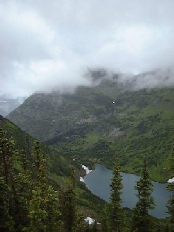
From the Brown Pass junction we turned to a new trail and started going steeply downhill to Olson Creek valley. The weather was getting better and we could see wonderful Thunderbird Mountain and Waterfalls. A couple of groups were coming uphill. We very quite happy to go down. Again there was a lot of leaves on the trail. And they made our pants very wet under our knees. That was not so nice, when also your socks got wet and even your boots got wet inside from the socks. We could even see Kevin and Tina under us, but they had also a nice speed, so we couldn't catch them yet. Charles and I were pretty hungry, so we decided to have alunch break. During the break it started to rain. We had to wear our rain gear and cover our backpacks. Them we started hiking again. Actually, it's not so bad to walk when it's raining, if you just have a good gear. We passed some nice nature monuments, like a rock field (a devil's field as we say in Finland) and some avelance areas, where they were still cutting trees. Quite soon we could already see Waterton Lake in the bottom of the valley. We were still quite high above the lake. When going down we also catched Tina and Kevin, when there was less than a mile to our campsite. Anyway, we all had walked really fast, because it took only a little bit more than 5 hours to get to our campsite. Nothing new, when getting to the campsite. Tents up and hopefully tents were also drying after the rain last night. There were a lot of mosquitos in the Waterton campsite and even I had to use some bug spray.
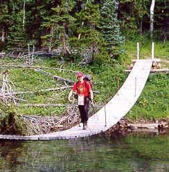
We were hanging a round and spending some time. We were a little bit worried to see the river crossing close to the campsite. Later, a single bagpacker came to the same sties and told us that there is a bridge about a half mile upstream, if we wouldn't like to cross the river in water. We walked up to check the bridge and also visit Waterton Ranger Station. A route to the bridge was about 3/4 miles, but anyway that was easier than cross the river with heavy packs. The trail on the other side of the river was a real highway, because the Ranger Station was so close. And then we were back in the civilisation. They had even electricity in the Ranger Station. The rangers thought we were hurring to the boat when we got there. The lake is halfly on the Canadian side and they have boat trips from the Canadian side to the US. People are making day hikes in the US side and then taking a boat back to Canada. We were not going to Canada, just checking the Ranger Station. Boats were leaving just outside the station, and when we were walking to the pierce, a ranger asked us first that if we missed the boat. No, we didn't. So she understood: "you are probably going to use the water closet. Yes, we were. We were disappointed because it was so cloudy and we couldn't see almost any mountains. Officially, I was probably in the illegal area, because when coming back, we saw a sign, only US citizens are allowed to come further. September 11th effected life also here in the woods, at least theoretically. When going back to the site, we also visited Rainbow Falls. The most impressing thing there was to see bear scratch on fallen trees.
We made a dinner and also a fire when it was allowed here. We talked also with a single hiker. Actually he had his 30 year anniversary, because 30 years ago he made his first hike in the Glacier National Park. Just when we were going to dry our boots, it started to rain. First even sub-freezed water and then it started to rain cats and dogs. We couldn't dry anything but ran back to our tents not to get wet.
4th Day Monday 8/5/02 Waterton River - Stoney Indian Lake (12.9 km, elevation up 650 m down 0 m)
I woke up at 3 am, somehow I can hear Val and Charles talking in the tent next to me. Then I notice the light. I'm wondering why they are using they flash lights in the middle of the night. Soon I notice that it is a little bit bigger flash light. There is a thunder storm in the valley. In the morning I notice that my tent is also wet inside, that is not so nice for the rest of the week. Also everybody else are worried about the wet gear and also if there will be a new storm next night when we are supposed to be in the mountains at 6000 feet, when we are now in the forest at 4000 feet. We decided to ask the rangers the weather forecast and if it's possible to stay somewhere else if the weather seems to be bad.
Tina and Kevin started hiking first. After a few hundred feet we can see them coming back, like we saw in the bear safety video before coming to the park. It's not a bear, but at least as terrible bird attacking towards us. First we thought it's a owl, but then it found out to be a ptarmigan. It attcks further and further, eventhough Tina tries to prevent it with her pole and we are really noisy and we are whistling. Then the bird notice that we are not dangerous or we are too big for her. We walked to the ranger station and had a break there. A ranger came also there and we asked him what would be the best way to do with a possible storm. He said, that it's not possible to change the site, but he thought that the weather would be fine and we could even dry our gear at Stonet Indian Lake camp site. We could also help the ranger, because in his radio somebody asked the current situation at Hole-in-the-Wall, especially about the snow. "Everything is fine there, and the view is gorgeous", we told him, and in that way also to the new backpackers behind us.
From Waterton Lake we followed in the modern way a new pipe digging way. Earlier the electricity has been produced from propane, but now they are changing to the water power. We were walking in Waterton Valley to Kootenai Lakes. The camp site is about half a mile from the trail, but we decided go there, because we were told to see moose there. And my friends really wanted to see moose. For our disappointment there were not any moose. The guys stayed overnight there told us, that earlier there were a couple of moose, but now they were hidden somewhere. A huge track was the only evidence about the animals. We continued to follow a river. The wather was clear and we had to take off some clothes, when it was even too hot at least in more open areas. We came to the trail junction there we should turn to left up to Stoney Indian Pass. There was a nice place for a lunch break. During the lunch we noticed that there was much more people in the east side of the park. One female single hiker joined us for her lunch and a 6-person group with quite young backpackers passed us also.
After the lunch the uphill started. Up and up. Steep uphill with switchbacks or then without. There was less trees up here and it turned to fresh and wet bushes. And there was uphill and uphill. We needed quite many breaks to breath. One was near a snow btach and a animal jumped to the batch and rapidly back to the bushes. Could it be a mountain lion, that the ranger told to be seen in the Stoney Indian Lake area by some backpackers? We walked still to uphill and lately we came to the camp site. The site was gorgeous like Hole-in-the-Wall. The lake was like a pot under the pass. A bad side was that the food area was quite far away from tents with steep 10-feet down and uphill. The weather was sunny and perfect for drying our wet gear after last night. Low bushes were also perfect for drying surface.
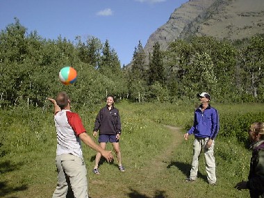
Normal camp work, water filtering and washing cloths were next program. It was so warm that we needed some washing also for ourselves. We decided to be courageous and jump to the lake, even there were still some snow batches. At least the swimming made us feeling more fresh. It was sunny and slightly windy, so our wet gear dryed soon and nicely. At the dinner we got more company, even more than two backpackers, when a dear came to beg some food. We didn't give anything, but the dear was walking around us just few feet from us. In this site there was a pole, not a cable like in the other sites to hand the food. During the night we played some football and were wondering the view and a nicwe sunset behind the great mountains. We couldn't see the mountain lion, even we were trying to find it. The football came a little bit dangerous, when the Kovach brothers were throwing the ball over the river so that the distance in lengthwise was 100 feet and in heigthwise some 30 feet. They didn't loose the ball anyway, even it was a couple of times in the waterfall. A though uphill in the afternoon worked and soon we heard our sleeping backs calling us loudly.
5th Day Tuesday 8/6/02 Stoney Indian Lake - Glenns Lake Foot (14.0 km, elevation up 310 m down 750 m)
The morning was really fresh. This time we woke already at six am. The sky was cloudless. What a great morning! To make breakfast in the food area. We were almost ready with making the breakfast, when black clouds appeared. And the first drops. And then we were busy. We had to stop the breakfast and ran to tents to save everything we could. I was lucky when I had packed most of my gear. The tent was only one to get really wet. After waiting for a while the rain didn't stop. So, the only possibility was to pack the gear when the rain got lighter. The tent was really wet and heavy, when I was packing it. We decided to go to the train in the rain. We would have a nice morning exercise 1000 feet up to the pass.
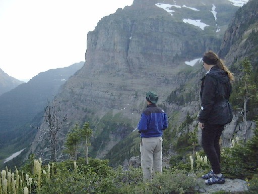
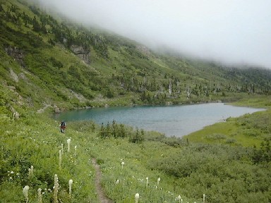
The uphill early in the morning was not so bad and after 40 minutes we were up in the pass. The weather was still grey, but the view to the Stoney Indian Lake was great. We took many photos before started steep downhill. It was many waterfalls also here and the trail went round Atsina Falls and we took a lot of nice photos especially with a great view to Glenns Lake Valley. We could hear some whistling and we saw a couple coming uphill. We were thinging them having seen a bear, but they told us just to be carerful, when they were coming first in the morning up in the bushes. They were really happy to meet us coming down the same trail. They also took our official group photo above in the beginning of this story, to be sure with three different cameras. Quite many people were coming uphill, and we were happy to walk downhill. We were walking quite fast. Even too fast when Val twisted her angle again and couldn't walk very well any more. We walked on and in Mokowanis Junction camp site Tina, Kevin and I had a small break. But Val and Charles walked on, when Val was feeling better not rest her angle.Soon they also got some company when a dear started to follow them. Again we followed a lake and there was still enough walking. Was it the rain in this morning and steep uphill right in the beginning, because we were feeling very tired? We were walking and walking and not got to the site. Of course then we got there. Quite nice place, on a field just by the lake and the site were just a couple of feet from the lake. Nothing to complain when the sun was shining and there was enough wind to dry again our gear.
Tired we were having our lunch. But soon we were busy again when noticed black clouds coming to the valley. The gear was mostly dry, so we were busy to cover tham again. All the time the rain was coming closer and closer, but we were lucky and it never got to our camp site. Mostly we were just resting and spending the time. We were also wondering why it was so tough day today. Val had a beach ball with her. And when it was shining we were playing with the ball. We also met two guys from Alabama. Also two couples at age of 20 to 25 years came to the site. The girls didn't join the trip too much, at least they were complaining all the time. "Why are we here, when it's so cold, it's raining all the time, we can't get real food, we don't have nice beds"? Something to think for all of us... Well, I think they had some sense of humor when asked if they will come back next year, they told "we think so". Latrer in the evening we had dinner of course and played again so football. We decided to go bed early, even we could sleep longer next morning, because there was just 1.5 miles to the next site to the next lake.
6th Day Wednesday 8/7/02 Glenns Lake Foot - Cosley Lake (2.4 km, no elevation up or down)
This will be an easy day. The wake-upp call was at 8 am, because we wanted to be late enough in the next camp site so that the backpackers stayed last night there would have left the site. But the last day was quite hard, so we were not frustrated to sleep longer and walk just some one mile.
After the breakfast on a trail again. And just when we were getting warmed we got to the next camp site. The site was quite much diferent even we were just on the next lake. The beach was like small stones here and it was calling us to take some morning sun. We were lying on the beach anmd resting the morning. We also noticed that in this site there were toilets for women and men separately. Very interesting.In the site there was a group of four guys, that we have actually seen last day when they were making a day hike to Stoney Indian Pass. They have had quite hard day and I don't wonder why. Then we had a lunch and started to prepare for our day hike.
Lake Elisabeth was our destination this afternoon. We have heard many backpackers tolding that Lake Elisabeth is the best place for fishing, and Kevin wanted to try his luck. We estimated the distance first to be about three miles, then with a better map about 4 miles and the truth was probably some five miles. We just took something to drink with us and Kevin's fishing pole. We wete just three guys, because Tina and Val decided to stay in the camp site. In the beginning the trail went through a meadow and we saw a big buck just close to us. Then we found a lot of raw blueberries. And then a fresh brear boo, it was clear what the bear has eaten, blueberreies. There was two trail and we took the one going to Lake Elisabeth. In the head of Cosley Lake we got some troubles: river crossing with a cable. Kevin had sandals so it was easy for him. Charles and I took off our boots and walked over the ice cold river. At the same time a family was coming from other direction. On the other side of the river we were drying our feet and talking with the famile, when suddenly Kevin saw a huge black bear on the other side of small backwater. We estimated the bear weight even 300 lbs. The bear hardly noticed us, drank some water and walked back to the woods. Well, we got some new excitement when the bear was walking to the same direction as we did too. But we couldn't see the bear anymore. On our way to Lake Elisabeth we visited Dawn Mist Fall. Very nice falls there water was dropping vertically some 60 feet. We also noticed why the are called Mist falls, because there was mist all the time under the falls. After a short break, we walked on. When we got closer to Elisabeth Lake mosquitos got really angry. There was a clearly difference between areas, when there was some mosquitos on Cosley Lake, but they were not even close this angry. Finally we reached Elisabeth Lake and Kevin started fishing. Charles and I were waiting on the beach and having cold. The temperature was much lower here. We decided to start hiking early enough so we would be back in Cosley Lake at dinner time. Because the distance was longetr than we thought Kevin didn't have too much time for fishing, but enogh to get some anyway. Then almost running back. Finally we were back there after close to 10 miles and four hours. Quite a day-hike!
Later we swam in Cosley Lake and ate the last camp dinner. We were hanging around and drank Val's everckean bottle empty. Finally it got dark and we couldn't play anymore beach ball so we had to go to the bed.
7th Day Thursday 8/8/02 Cosley Lake - Chief Mountain Customs (14.2 km, elevation up 230 m down 80 m)
The last morning. We were really quik this morning, but we had made some plans last night how to be as quik as possible. The night had been rainless and windy, so our tents could be packed pretty dry. Every leftovers for the breakfast and then to the trail.
The purpose of the last day is to get to the finishing point, isn't it. So, we didn't spent too much time for the views etc. Although the view was gorgeous. The mountains in the east side of the park were quite different compered to the west side, we could see the different rock layers especially on the side of separated Chief Mountain. We were walking again in an old forest fire area, because all the trees were exactly at the same size. After an hour walk we got down to the Belly River Valley, there a ranger station could be seen in the middle of the meadow. We crossed the river with a nice bridge and then the trail turned to follow the river towards Canadian border and to our final destination at Chief Mountain Customs. We were walking on the meadows and there was enough bugs again. The sun was burning us from the cloudless sky. But the trail was going on and on. A 1:100 000 map was not detailed enough to follow where we were going. At least it differed from the real life quite much. In the end of the trail there was a 500 feet uphill to the pass with switchbacks. The contrast between first-day hikers just starting their trip and seventh-day totally exhausted backpackers was huge, when we were climbing the uphill with the last streght of ours. "Only half a mile", "well, NOW it's just half a mile", "a quarter of mile left, or just a little bit more". Finally we could see a parking lot, and last a couple of hundred of feet was mentally so much easier.
We were really much too early on the parking lot. Of course we had targeted to be like two hours too early there before our shuittle service. But we had walked about an hour faster than we thought. And it was just over the noon, when our pick-up time was 4 pm. On the lot there was a shuttle from our company, so we decided to ask him. And we were really happy when the driver told that he came to pick up us! And best of all he had some ice cold beer for us. We changed some cloths and drank beer for a perfect backpacking. The we packed the shuttle and started driving to Polebridge. The direct distance was about 50 miles, but the Going-to-the-Sun Road was the only road going through the park and our shuttle was too wide and long for the GTTS. So we had to drive around the whole park and it would take 4 to 5 hours. We stopped at Saint Mary to have a luch. Oh so nice were the sandwitches and fatty fries! Then we drove further and our driver Gary was telling us almost everything about the park. Every now and then we stopped to walk a little bit and also buying some food for the evening and next morning. After four and half hours we were back in Polebridge. Tina, Kevin and I stayed at hostel and Val and Charles picked up their truck at Bowman Lake. The maybe most waited shower was waiting for us at the hostel and we could at least flush some of dust on our skins. Soon also Val and Charles joined us.
Epilogue
The shower was really refreshing. Tina and Kevin drove to the cabin. When Val and Charles were also ready, we drove to Mercantile to buy something more for the breakfast and ice also. We noticed that in the next door in the Northern Light Saloon was really booked. There was at least 50 people and kids, mostly outside the saloon because inside there was some 20 seats. The kitchen was only open until nine and it was already 8 pm. We were going to have a dinner there, so Charles stayed there trying to get table and Val and I drove to the cabin to left our bags and pick-up Tina and Kevin. Charles was lucky to get a table and to make an order. The local beer was called Moose Drool and it was tasting interesting and heavy like Guinness. Everybody had enough to eat and they also had some dessert although they said something else in the beginning. It was quite wild in the saloon, when inside and outside the saloon there was some much local people and tourists. There was not any other places close to Polebridge, means within tens of miles. So everybody is coming to the same place and the speed like that. Like in Wild West. If the people would have dressed like in 18th century we could have been in some of thos gold rush movies.
After the dinner we drove back to our cabin. We organized our gear and sat on the fire until we got tired enough to go bed. We would have an early wake up, when my friends wanted to start driving as early as possible. They would have some 2000 miles to drive back home. A fast-breakfast and we were on the road at the same time with sunrise. I would stay in Kalispell to wait for my flight back to Europe next morning. We were at my hotel already at 8 am. I was extremely lucky to get a room right away, when the official check-in time was at 4 pm. I slept for a couple of hours, that I really needed. Then I was walking in the mall and Kalispell downtown. I also bought some souveniers and basicaly just spent some time and rested after the backpacking. I went to bed early enough so that I'll be ready for the shuttle to the airport at 4:40 am and my plane would take off just after six am.
In the airport they of course took me to the special security control. In a small town a foreigner is always something strange. All my luggage was emptyed when they had no x-ray machines there. The face of the guard was something when he was going to open my bag with dirty cloths. "I'll check this just outside". The officer was really friendly any way and there was not any problems. Then the long way back home. First to Salt Lake City, then to Atlanta and three hours waiting for the Brussels plane. Eight hours flight to Brussels and after landing it took one hour on Sunday morning to find what I should do there and where to go. The guidance was really bad at the airport. Well, I had enough time, because it took 7 hours before my plane to Helsinki would take off. The just a short (three hours) flight to Helsinki and when everything went fine and also my luggage got to Finland, I was back in home in Lauttasaari 29 hours after left hotel in Kalispell. I was totally tired, but happy after extremely gorgeous backpacking tour. Next morning the alarm woke me up at six am and back to the normal work. But there was something to bre remembered in the dark winter nights.
Kuulostiko kiinnostavalta? Lisää tietoakin annetaan haluttaessa!
If you want to know more, just email me!
Leider ist unseres Glacier National Park nur im Finnish, aber wenn Sie mehr wissen wollen, schicken Sie mir E-mail, bitte!
[email protected] tai/or/oder [email protected]